
This is a short update. Information here can go outdated quickly and without warning. I am sorry for the Google Adsense popup ads. They turned them on without telling me and I can’t turn it off. I never run this type of ads because this is just annoying pop-up and I don’t allow that on my website. Google Adsense ads are going to be gone by the end of this month anyway (regardless of anything else).
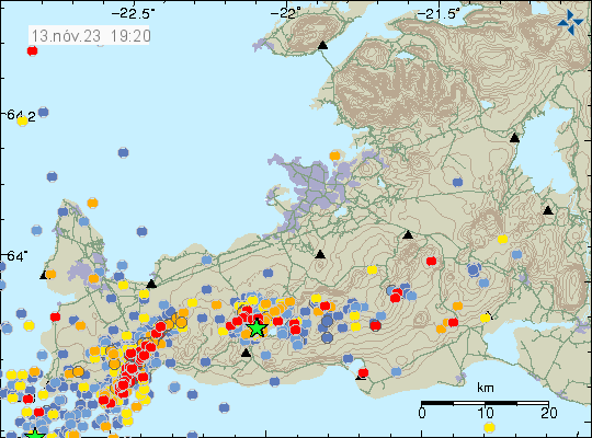
The situation is similar to yesterday. Earthquake activity continues to drop for now. But that might be a short quiet because the dyke and the rift valley continues to grow. Inflow of the magma continues, at slightly slower rate than on Friday 10. November 2023.
- The inflow of magma on Friday 10. November 2023 was 1000 cubic meters per second according to Icelandic Met Office and experts.
- The rift zone that is lowering is on the western side of the Grindavík town. The east side is rising up to almost the same amount. Parts of Grindavík have lowered around 1 to 2 meters. Some of the cracks in the grounds are up to 20 meters deep or deeper.
- There is a lot of damage in Grindavík to many houses. If not from earthquakes, then from the formation of the rift valley.
- Eruption risk remains high and the dyke seems to holds its length at 15 km. This can change without warning.
- The rift valley is now around 2 km wide according to the news. The rift valley continues to get wider according to measurements.
- There has not been any drop in harmonic tremor on SIL stations next to the dyke, even if earthquake activity has lowered. This is because of the ongoing inflow of magma into the dyke.
It is not possible to know what happens next. It is my view that an eruption is going to start in this area. This is a start of a activity that is going to last for a while until it quiets down.
This dyke activity might also upset the volcanoes Fagradalsfjall and Reykjanes and what is happening in them. Anything can happen in them without warning. If not eruption, then earthquake activity.
I’ll post update when I have some new information about this situation.
Just wanted to say thanks for your updates; I have been linking to and referring to them on my blog (Flight to Wonder).
I tried Google Adsense and others, got no results, and had a terrible time getting out of the program. One has to already be big to get any benefit from Internet ads — they just farm us small-timers for a steady income, I think.
On to the main thing: on today’s elevation imagery of the rift near and through Grindavik, I noticed that there is no western “rift wall” elevated, as there is to the east; in fact, the depression, although slight, extends west of the hills that include Thorbjorn and Sylingafell.
While deformation continues here, and it is certainly possible there will be an eruption in this rifted zone, I am also impressed by the amount of deformation to the east of the whole area shown on the InSAR image released today (this would be north of the recent dike).
It looks to this layperson as though ridges to the east are blocking magma extension in that direction, thus far successfully.
Southward directed force would result, and apparently an old crack was available for dike formation — but not enough force was available for the dike to completely reach the surface.
I hope for the Grindvikings sake it never does, but it could; if not, and if that eastward expansion of the main body continues to be blocked, then perhaps other old cracks west of the hills could open.
Or something might give way somewhere else. It’s fascinating but horrible for all the people involved.
Sorry for this length — a question: are there any public-facing sources of volcanic gas measurements available? I’m curious why no SO2 effects have been reported with magma so close to the surface and the presence of people from time to time in Grindavik.
Thanks. This I fear is just start of the trouble that Grindavík town is in. What is going to happen in the future is something I do not know.
Do you have links to the tremors charts? Can’t find them on iceland met office page anymore.
Hi Einar, for med the charts cannot be viewed in Google Chrome any longer. Try another browser: http://hraun.vedur.is/ja/englishweb/tremor.html
The tremor plots can be found here. But you need Firefox to view them since Google Chrome does not work any more.
http://hraun.vedur.is/ja/oroi/allarsort.html
http://hraun.vedur.is/ja/oroi/index.html
I just wanted to thank you for the regular updates. I’m a keen learner of geology and volcanology and you provide a constant supply of reliable, up to date information, which I’m very grateful for.
I was just reading that SO2 has now been detected in the area which would mean magma is very close to the surface