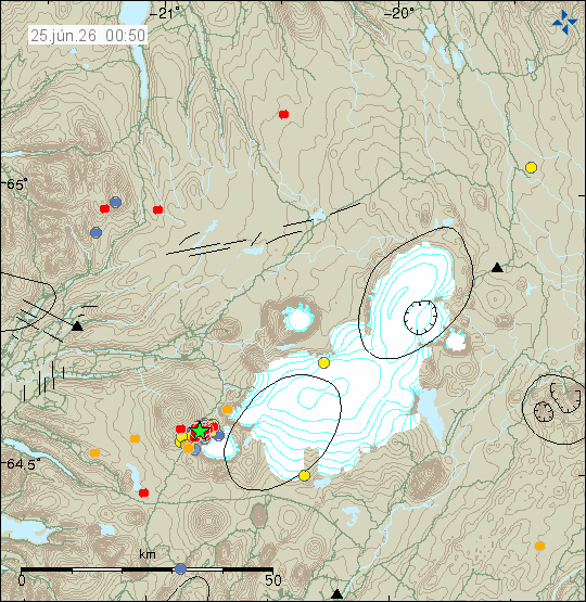
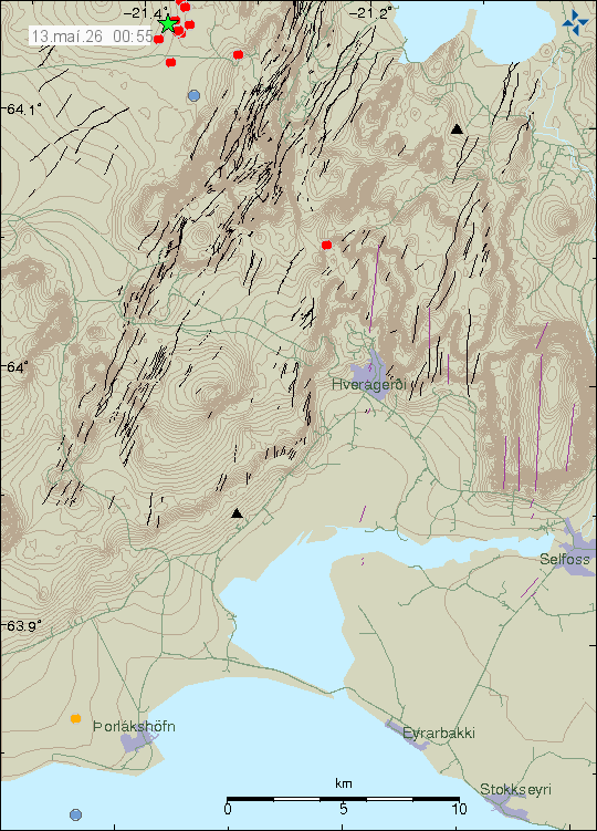
Yesterday (24-June 2026) an earthquake with magnitude of Mw3,3 took place just south of Presthnúar volcano. This earthquake was part of an ongoing earthquake swarm in this area.
Earthquake activity south west of Presthnúkar volcano in Langjökull glacier. Copyright of this image belongs to Icelandic Met Office.
Based on earthquake data. I believe this earthquake activity is because of magma movement in the crust. I don’t think this is going to result in a eruption in this area. At the moment, the earthquake activity is too small for that too happen. This type of earthquake activity can go on for months and sometimes years before it stops.
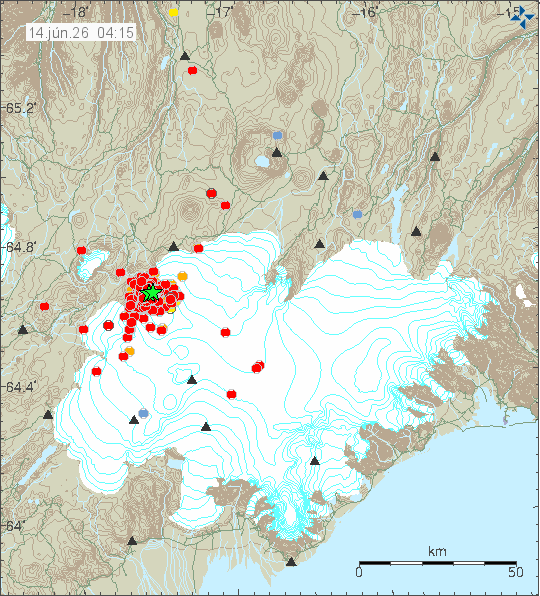
Yesterday (13. June 2026) at 20:14 UTC an earthquake with a magnitude Mw4,8 took place in Bárðarbunga volcano. This earthquake started an earthquake swarm in Bárðarbunga volcano that lasted until around 05:00 UTC before it did quiet down. Around 400 earthquakes where recorded in this earthquake swarm before it stopped. Total of six earthquakes with magnitude over Mw3,0 took place in this earthquake swarm.
Earthquake activity in Bárðarbunga volcano during the night. Copyright of this image belongs to Icelandic Met Office.
The source of this earthquake swarm is movement of magma in Bárðarbunga volcano. This time, it did stop and not result in a eruption. An earthquake swarm of similar nature took place in Bárðarbunga volcano last year. Its is a possibility that this earthquake activity is not over, even if nothing has happened for more than 12 hours at the writing of this article. The source of this is magma and it is impossible to know what happens next. Bárðarbunga volcano has been inflating since end of the eruption in 2015. After it collapsed in that same eruption, during a caldera collapse event and lowered about 60 meters. Last inflation number suggested that it has inflated about 30 meters from lowest point.
If anything more happens. I am going to write a new article about what happens.
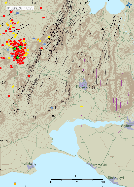
Since Sunday, 31-May 2026 there has been a earthquake swarm in Brennisteinsfjöll volcano. This earthquake swarm is ongoing at the writing of this article. Largest earthquake so far has had the magnitude of Mw4,5 today (1-June 2026) and was felt over a wide area. A second Mw3,8 earthquake also happened today. A magnitude Mw3,5 earthquake took place on 31-May 2026. All of the largest earthquakes have been felt.
The earthquake swarm in Brennisteinsfjöll volcano. Copyright of this image belongs to Icelandic Met Office.
This earthquake activity does not seem to have its origin in magma movement. This rather seems to be because of a rift zone valley movement in this area. That can result in magma movement at later stage, at the moment however, that does not seem to be the case. If anything more happens. I am going to write a new article with updated information.
Article update on 3-June 2026 at 23:02 UTC. New information shows that this earthquake swarm is happening in Brennisteinsfjöll volcano and not in Hengill volcano that is nearby, just slightly east of the earthquake swarm.
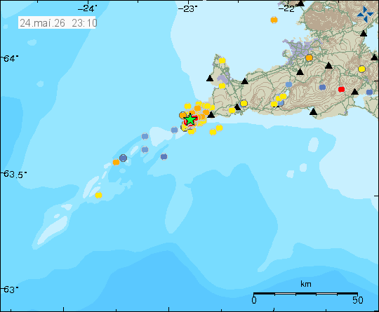
Since Saturday, 23rd of May 2026 an earthquake swarm has been taking place in Reykjanes volcano. This earthquake swarm does not signal a start of an eruption, but it might be a long term signal in that direction. Largest earthquake in this earthquake swarm at the writing of this article had a magnitude of Mw3,5. Second largest earthquake had a magnitude of Mw2,9.
Earthquake activity in the Reykjanes volcano. Copyright of this image belongs to Icelandic Met Office.
At the writing of this article, the earthquake swarm is ongoing, but in a much slower phase. It is possible that this earthquake swarm is already ending or might end in next few hours. It is also common for earthquake swarms to increase suddenly again in this area. Currently, this is a wait and see situation.
After a long period of very quiet time in Iceland. A earthquake with magnitude of Mw3,6 took place in Hengill volcano, close to an area called Eiturhóll. This area has frequent earthquake activity related to tectonic movement.
Earthquake swarm in Hengill volcano. Copyright of this image belongs to Icelandic Met Office.
The largest earthquake started a small earthquake swarm that is currently ongoing at the writing of this article. I am not expecting more earthquake activity then has already happened at the writing of this article.
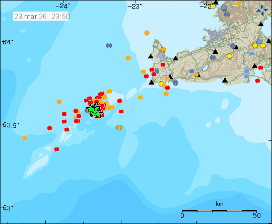
Today (23-March 2026) at 12:08 UTC an earthquake swarm that had been going on since at least Friday (20-March 2026) increased in activity. Largest earthquake at the writing of this article had a magnitude of Mw4,4 and was felt in Reykjavík and other populated areas on Reykjanes peninsula.
The earthquake swarm at Geirfugladrangur island. Copyright of this image belongs to Icelandic Met Office.
This earthquake activity happens in waves. That means a lot of activity for up to four hours at the time or longer, with low activity for one to three hours at the time. This changes every few hours. I am reading this as there is magma that is causing this earthquake activity. It might not result in a eruption at the moment. If there is a very sharp increase in earthquake activity, that might be a sign that magma is breaking a path to the surface. What is happening now, is at possible dyke intrusion into the crust at Geirfugladrangur island. However, distance from land, this being under the ocean makes it real difficult to monitoring what is going on and to be sure what is going on.
If anything more happens. I’ll update with a new article soon as possible.
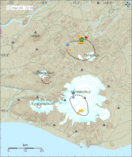
This morning (12-March 2026) at 11:47 UTC an earthquake with magnitude of Mw3,7 took place in Torfajökull volcano.
Earthquake activity in Torfajökull volcano. Copyright of this image belongs to Icelandic Met Office.
A small earthquake swarm followed the main earthquake. There are no signs of magma movement in the area. But this area doesn’t erupt basalt lava, so it might be difficult to tell or know if there is lava on the move. Magma erupted in this area most of the time is Rhyolite. Just detecting this type of magma movement might be difficult. There has been some minor inflation in Torfajökull volcano, but it might have stopped few years ago.
I am sorry about being late with this. I got a cold again with its usual problems.
On Sunday 8th February 2026 an earthquake started in Reykjanes volcano, in the area of Eldey island. Around 1000 earthquakes where recorded. Largest earthquakes had a magnitude around Mw3,4. Other earthquakes where smaller in magnitude.
The earthquake activity on Reykjanes ridge, close to Eldey island. Copyright of this image belongs to Icelandic Met Office.
This earthquake swarm is possibly connected to the inflation that is happening in Svartsengi volcano, as that inflation changes stress in faults along the Reykjanes peninsula and Reykjanes ridge. How well that stress results in earthquakes in unknown. It is unclear if magma was also active in this earthquake swarm. It should not be ruled out. No eruption did happen in this earthquake swarm. More earthquake swarms in this area of Reykjanes ridge and Reykjanes peninsula should not be ruled out.
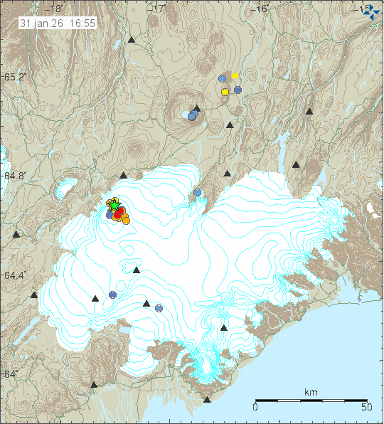
Today (31-January 2026) at 11:54 UTC an earthquake with the magnitude of Mw5,3 took place in Bárðarbunga volcano. This earthquake was not felt in populated areas. This earthquake is part of the inflation process in Bárðarbunga volcano. This process has been going on since the eruption in Bárðarbunga volcano ended on 28-February 2015.
Earthquake activity in Bárðarbunga volcano. Copyright of this image belongs to Icelandic Met Office.
This strong earthquake activity in Bárðarbunga volcano is going to continue until maximum inflation is reached or until next eruption start. Whatever comes first. Then this cycle is going to restart in some form once a eruption has happened. If maximum inflation is reached, then this type of earthquake activity is going to stop. Based on current data, it is going to take several decades until that happens.
Yesterday (24-January 2026) from 10:27 UTC and until 12:02 UTC an earthquake swarm took place in Þórðarhyrna volcano. This earthquake swarm looks like a dyke intrusion in that volcano. Largest earthquake had a magnitude of Mw2,8 and other earthquakes where smaller in magnitude.
Earthquake activity in Þórðarhyrna volcano. Just south-west of Grímsfjall volcano. Copyright of this image belongs to Icelandic Met Office.
This earthquake activity is showing a increase in activity in this volcano over the recent years. There has not been a eruption in Þórðarhyrna volcano since 1830 to 1903 (year is uncertain). This volcano is inside Grímsfjall volcano fissure swarm. There are no clear signs that eruption is going to happen any time soon. This increase in earthquake activity might continue for next 10 to 20 years before an eruption happens in Þórðarhyrna volcano. There are more information about Þórðarhyrna volcano on Icelandic Volcanoes website.