Update on Grindavík 17. November 2023

This is a short update on the situation in Grindavík on 17. November 2023. Information here can go outdated quickly and without warning.

Daily updates

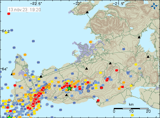
  • Grindavík town continues to sink as the rift valley continues to move. The speed of sinking has slowed a little according to the news today.
  • Earthquake activity has slowed down in last few hours (this is written around 22:51 UTC). What that means is unclear.
  • Some houses in Grindavík town have been completely destroyed. Iceland has a natural disaster fund for this type of situation and that is going to cover the owners loss according to the news.

General update

It took me a week. But it seems that this dyke intrusion under Grindavík town is because of the magma sill (dyke) under Svartsengi. That area has inflated around 110mm in a week. That is a inflation of 15mm/day based on my best calculations. That is a lot of inflation, since before 10. November the inflow of magma into Svartsengi was at most 8m3/sec according to measurements of Icelandic Met Office.

The sill in Svartsengi created a lateral dyke in Sundhnúkar and nearby areas. When the pressure in the sill is high enough again it is going to push the magma into the dyke at Sundhnúkar again with the same force as it did before. How long that takes I don’t know. Last time this was from 25. October to 10. November. That’s seventeen days, but there was a lot of deeper sills in Svartsengi and its impossible to know much, if anything flowed form them into the dyke. This is my personal view, it might be wrong. But this is what I am reading from the data.

Risk of the eruption remains high because there’s a ongoing inflation at Svartsengi. When a eruption starts is impossible to know.

If anything happens. I’ll post update soon as I can.

Update on Grindavík 15. November 2023

This is a short update on what is happening in Grindavík on 15. November 2023. Information here might go outdated quickly.

In general, not much has changed since yesterday (14. November 2023).

  • There’s no change in earthquake activity. Strong wind in the Reykjanes peninsula might be masking some of the smaller earthquakes.
  • Part of the harbour area has started to sink according to news. I am not sure how much, but I think it might be considerable sink.
  • Speed of the sink in some areas of areas inside Grindavík has increased from 7 cm for each 24 hours to 12 cm for each 24 hours since yesterday. Some areas inside Grindavík have lowered as much as 2 meters or more.
  • Inflow of magma into the dyke continues to be at 75 m3/second according to news reports today. This is a lot of magma inflow into the dyke. The eruption in Holuhraun in 2014 and 2015 had an flow of 90 m3/sec when it was the most.
  • It is reported on mbl.is that it is now considered that magma might be flowing directly from the main magma chamber at 20 km to 40 km depth under this location in Reykjanes peninsula. That news is in Icelandic here.
  • Parts of Grindavík town has lost power, hot and cold water because of sinking of the ground and movements. Emergency repair is going to be attempted tomorrow if it is safe.
  • Eruption might happen at Sundhnúkar and Hagafell, where the highest flow of magma is happening according to Icelandic Met Office and the news.
  • Eruption at many craters at the same time is what is going happen here. Based on what I am seeing. That means more lava covering larger area quicker than the small eruptions in Geldingadalir, Meradalir and at Litli-Hrútur. Where it was just one crater and a small eruption.
  • Something is holding back the magma from reaching the surface. What that is unclear. But magma is at shallow 500 meters or less according to measurements done by Icelandic Met Office. This shallow depth means that magma can start erupting without much warning or notice in the dyke.

There is a chance that parts of Grindavík town might sink under the ocean because of the ground sinking. When eruption starts, what goes under lava depends on where the eruption is going to start and where the lava is going to flow. Both are random events that is impossible to know anything about.

If anything happens. I’ll post update soon as I can. If anything happens tomorrow I’ll write about it. Otherwise I plan on publishing next article on Friday 17. November 2023. Since changes at the moment are not that big changes between days currently.

Update on the situation in Grindavík on 13. November 2023

This is a short update. Information here can go outdated quickly and without warning. I am sorry for the Google Adsense popup ads. They turned them on without telling me and I can’t turn it off. I never run this type of ads because this is just annoying pop-up and I don’t allow that on my website. Google Adsense ads are going to be gone by the end of this month anyway (regardless of anything else).

The situation is similar to yesterday. Earthquake activity continues to drop for now. But that might be a short quiet because the dyke and the rift valley continues to grow. Inflow of the magma continues, at slightly slower rate than on Friday 10. November 2023.

  • The inflow of magma on Friday 10. November 2023 was 1000 cubic meters per second according to Icelandic Met Office and experts.
  • The rift zone that is lowering is on the western side of the Grindavík town. The east side is rising up to almost the same amount. Parts of Grindavík have lowered around 1 to 2 meters. Some of the cracks in the grounds are up to 20 meters deep or deeper.
  • There is a lot of damage in Grindavík to many houses. If not from earthquakes, then from the formation of the rift valley.
  • Eruption risk remains high and the dyke seems to holds its length at 15 km. This can change without warning.
  • The rift valley is now around 2 km wide according to the news. The rift valley continues to get wider according to measurements.
  • There has not been any drop in harmonic tremor on SIL stations next to the dyke, even if earthquake activity has lowered. This is because of the ongoing inflow of magma into the dyke.
A line of red dots shows the dyke formation that goes under Grindavík town and goes north-east of the town.
The earthquake activity in the dyke appears clearly. Copyright of this image belongs to Icelandic Met Office.

It is not possible to know what happens next. It is my view that an eruption is going to start in this area. This is a start of a activity that is going to last for a while until it quiets down.

This dyke activity might also upset the volcanoes Fagradalsfjall and Reykjanes and what is happening in them. Anything can happen in them without warning. If not eruption, then earthquake activity.

I’ll post update when I have some new information about this situation.

Update on Fagradalsfjall mountain eruption on 9-July-2021

This is a short update on the eruption in Fagradalsfjall mountain that is part of Krýsuvík-Trölladyngja volcano system (currently, this might change in the future).

  • Since 23:00 UTC on 5-July-2021 the eruption has been on the low side and no lava has been seen leaving the crater when the fog is less dense in the eruption area. This is the longest break in the eruption activity since it started in 19-March-2021.
  • Small amounts of lava has been seen in the crater and it is speculated that it might be flowing from the crater in tubes in the lava field. This remains unconfirmed at the writing of this article.
  • Currently the eruption is not over. It is ongoing as is.

The following is a speculation on my part.

This lack of activity and amount of lava in the crater suggests that the deep system that has been feeding the eruption is for now close to being empty or is completely empty. That system of magma chambers needs time to fill up. This lack of activity is also common for this type of volcano and magma system. Since eruptions go trough a cycles of high and low activity. This might result in the eruption starting in a new fissure in next few weeks to months along with continuing in the current crater. There is also a equal chance of the eruption just continuing in the current crater once the eruption starts at full energy again. But that might be weeks until that happens.

End of speculations

Summer is fog season in Iceland when there is no strong wind and this has been a problem for monitoring the eruption on Reykjanes peninsula in recent days. This is going to continue until September or October depending on the weather pattern.

Donations

Please remember to support my work with donations. It helps me to keep my self running and to do normal day to day stuff with minor income from this work here. Thanks for the support. 🙂

Bárðarbunga volcano update for 30-January-2015

Since last update nothing major has changed in Holuhraun. There have been some changes in Bárðarbunga volcano it self and I am going to cover that later in this article. The magma flow from the craters in Holuhraun remains high at the moment, with latest flow measurements saying that flow of lava is now 100m³/sec. There seems to be uncertain or maybe changes in the flow of lava out of the crater. The volume is now ~1,4 km³. The lava-field has been getting thicker over the past weeks and closest to the craters it is now around 40 meters thick. New estimate of when the eruption might end are now 4 to 15 months.

150130_2050
Earthquake activity in Bárðarbunga volcano for the last 48 hours. Copyright of this image belongs to Icelandic Met Office.

Earthquake activity remains high, but it continues to drop at steady rate between weeks. Earthquake activity now also drops between peaks in activity. I still don’t know if a small eruption took place in Bárðarbunga volcano. Nothing has yet been confirmed and it might remain unconfirmed for a long time. I am also seeing small spikes in the harmonic tremor data due to hydrothermal activity in Bárðarbunga volcano (far as I can tell).

If anything major happens I am going to post update about it soon as I can.

Donations: Please remember to donate to support my work or support my work by shopping through Amazon links that I have here. Thanks for the support.

Bárðarbunga volcano update Monday 10-November-2014

No major change took place in the eruption in Holuhraun during the weekend. The lava field is now around 70 square kilometres wide and it keeps growing each day. I don’t know the total volume so far, since that depends on the thickness of the lava. Last calculations that I know of estimated it to be around 1,0 km³, it is save to assume that volume is now greater since the last estimate that I know of is at least one month old by now.

141110_2055
The earthquake activity in Bárðarbunga volcano. Copyright of this image belongs to Icelandic Met Office.

Largest earthquake this weekend had the magnitude of 5,2. Other earthquakes where smaller, but many magnitude 3,0 and larger earthquakes did happen as usual in Bárðarbunga volcano. The crust in Bárðarbunga volcano is now heavily fractured, this allows heat from the volcano easier way to the surface. This also means new hot springs are going to open up and older ones are going get more active. There is no major change in Bárðarbunga volcano eruption at the moment, as has been the case for most part of past two months.

Article on what is happening in Bárðarbunga volcano

I am working on a article (in my head at the moment) on what is happening inside Bárðarbunga volcano. It is not ready yet, I do hope to have it ready tomorrow if I can process all the data for the article, in order to properly figure out my self what is going on in Bárðarbunga volcano.

My geophone network

I run a geophone network of just two geophones in Iceland at the moment. Once I get an apartment the total number of working geophones is going to be three. I have decided that once I move from Iceland to Azores Islands[1] it is not going to be workable to keep the network running due the technical problems doing so. I am not going to stop recording earthquakes, I am just going to do so in Azores Islands. At the moment I also have four year backlog of earthquakes that I have to properly add time and location data to. That is a lot of earthquakes over this period, since large events have happened and Bárðarbunga alone added up to 2000 earthquakes to my earthquake database in August and now I add around 10 – 20 earthquakes from Bárðarbunga volcano each day (this is just average). The geophone network as it now stands is going to be running for the next 5 – 10 years while I live in Iceland, after that I am going to relocate it to Flores Island when I move there[2]. At the moment I don’t know for sure when that is going to happen, all I know now is that it is going to happen.

1: I am currently living in Denmark. I move next month to Iceland.
2: I plan up to ten years ahead so that I know what I need to do and know before I do it.

Bárðarbunga volcano update for Wednesday 05-November-2014

This is current status in Bárðarbunga volcano for Wednesday 05-November-2014.

There has not been any major change in the eruption in Holuhraun since Monday 03-November-2014. The eruption continues around the same phase as before. Earthquake activity continues to be strong as it has been for the past two months. With several magnitude 3 – 4,9 earthquakes happening every day, the amount of earthquakes is different between days.

141105_2105
Earthquake activity in Bárðarbunga volcano for the past 48 hours. Copyright of this image belongs to Icelandic Met Office.

It continues to be extremely dangerous going to the eruption site as two police men found out yesterday. They hit a pocket of dangerous gases that had removed most of the oxygen in the area where they had located them self, at the edge of the lava field and where some two to three kilometres away from main erupting crater. They almost passed out due to lack of oxygen and they where using gas masks according to the news on Rúv about this insistent.

Drop of the caldera in Bárðarbunga volcano continues at the same rate as before, the most drop is now around 44 meters in the caldera. Cauldrons in the glacier above Bárðarbunga volcano continue to getting deeper, the depth has increased around 5 – 8 meters in the past 11 days according to recent measurements. The amount of melt according to calculations is around 2 cubic meters per second (m³/sec). This is equal to energy release for few hundreds megawatts according to University of Iceland. It is now difficult getting to the eruption site due to winter in the area, travel by car is now at minimum seven hours the other way in best conditions.

Other than this I don’t think there is anything else new about Bárðarbunga volcano eruption at the moment.

Icelandic News

Færð gerir vísindamönnum erfitt fyrir (Rúv.is)
Lögreglumenn urðu fyrir súrefnisskorti (Rúv.is)

Bárðarbunga volcano update for Friday 31-October-2014

This is the update for Bárðarbunga volcano on Friday 31-October-2014.

Not much has changed since Wednesday (29-October-2014) update in Bárðarbunga volcano. Earthquake activity continues as it has been doing for the past two months. No major change has been taking place in according to GPS data. No major change has happened in eruption vents in Holuhraun, the lava field is now around 65 square kilometres in size.

141031_2105
Earthquake activity in Bárðarbunga volcano for the past 48 hours. Copyright of this image belongs to Icelandic Met Office.

Strongest earthquakes for the past 24 hours have the magnitude of 5,3 and 5,2. Other earthquakes have been smaller. There is no change in earthquake activity in Bárðarbunga volcano and the caldera continues to drop around 40cm/day at the moment. Current SO2 output levels are around 20,000 to 40,000 tons/daily of SO2 from the eruption in Holuhraun. Bad weather has blocked proper earthquake detection and monitoring of the eruption in Holuhraun and of Bárðarbunga volcano. The weather is going to be extremely bad in Iceland for the next 6 – 10 hours. Other than this I don’t have any more news of Bárðarbunga volcano eruption.

Article updated 01-November-2014 at 00:30 UTC.

Bárðarbunga volcano update for 27-October-2014

During the weekend activity in Bárðarbunga volcano was in the same manner as it has been for the past two months. Largest earthquakes during the weekend had the magnitude of 5,2 and 5,3. Pollution was a big problem south of the eruption in Holuhraun and new record was set for SO2 pollution in populated areas in Iceland. The pollution levels did go up to 21.000 μg/m3 when they where the highest during the weekend. A emergency was declared for Höfn in Hornafirði when the worst pollution did go over the area. Currently there is a little bit less pollution, but air quality is poor in parts of south Iceland at the moment.

141027_2325
Earthquake activity in Bárðarbunga volcano for the last 48 hours. Copyright of this image belongs to Icelandic Met Office.

Largest earthquake on 27-October-2014 had the magnitude of 5,3 and happened in the south-east part of the caldera. Since it has been quiet in terms of earthquake activity. According to Icelandic Met Office this is normal and has happened before. Subsidence of the caldera happens without any earthquake activity most of the time. According to Icelandic Met Office and others (pdf file here), the caldera has now dropped some 40 meters. New cauldrons have been forming along the caldera rim and older ones (that I did not know about until today) have been getting deeper according to measurements from Friday (24-October-2014). The new and older cauldrons appear clearly on images that can be found here (text is in Icelandic). GPS data is showing minor inflation in the dyke that is currently erupting, suggesting that more magma is flowing into it then is erupting from it.

If any melt is happening in the caldera it is not appearing on the glacier yet. As for the water, it just goes down. Rock inside volcanoes leaks, a lot, so it is easy for the water to go into the crust. It doesn’t have to go anywhere else in small amounts that might be melting if the crust has warmed up enough to do so. Currently there are no evidence for that taking place, but with 850 meters of glacier on top of it is difficult to be sure. There are no other news about the eruption that I know of at the moment.

Donations: Please remember to donate or support my work if you buy from Amazon to due so trough the banners I have here. Thanks for the support.

Bárðarbunga volcano daily update for 23-October-2014

Currently earthquake activity is increasing in Bárðarbunga volcano. For the past 48 hours 53 (when this article is written) earthquake with magnitude above 3,0 have happened. It is unclear what is going now in Bárðarbunga volcano, at the moment most of the earthquake activity is located in north-east of the caldera rim. I am unsure why earthquake activity is increasing the way it is currently doing.

141023_2020
Earthquake activity in Bárðarbunga volcano for the past 48 hours. Green stars show earthquakes with magnitude above 3,0. Copyright of this image belongs to Icelandic Met Office.

I am not sure if there have been any harmonic tremor this time around in Bárðarbunga volcano. That might well be without me noticing them. Even if the eruption in Holuhraun stops it is clear that Bárðarbunga is far from being a stable or in dormant state. A new eruption vent is more likely to open up then not. That might happen under a glacier and that is going to mean glacier flood and volcano ash eruption while water gets into the crater. This has not yet happened on large scale in Bárðarbunga. There is also no eruption taking place in the caldera at the moment and the glacier is getting thicker this time of the year due to fresh snowfall on top of it and making it heavier at the same time. Far as I know the eruption in Holuhraun is at the same pace as it was yesterday. I didn’t see anything on the web-cameras due to weather when I checked them earlier.

If anything major happens I am going to post update here soon as possible.