Update on the eruption in Sundhnúkagígar in Svartsengi volcano at 17th July 2025 at 00:43 UTC

This is a summary update with best information I have at the moment. Some information might be out of date without me knowing about it.

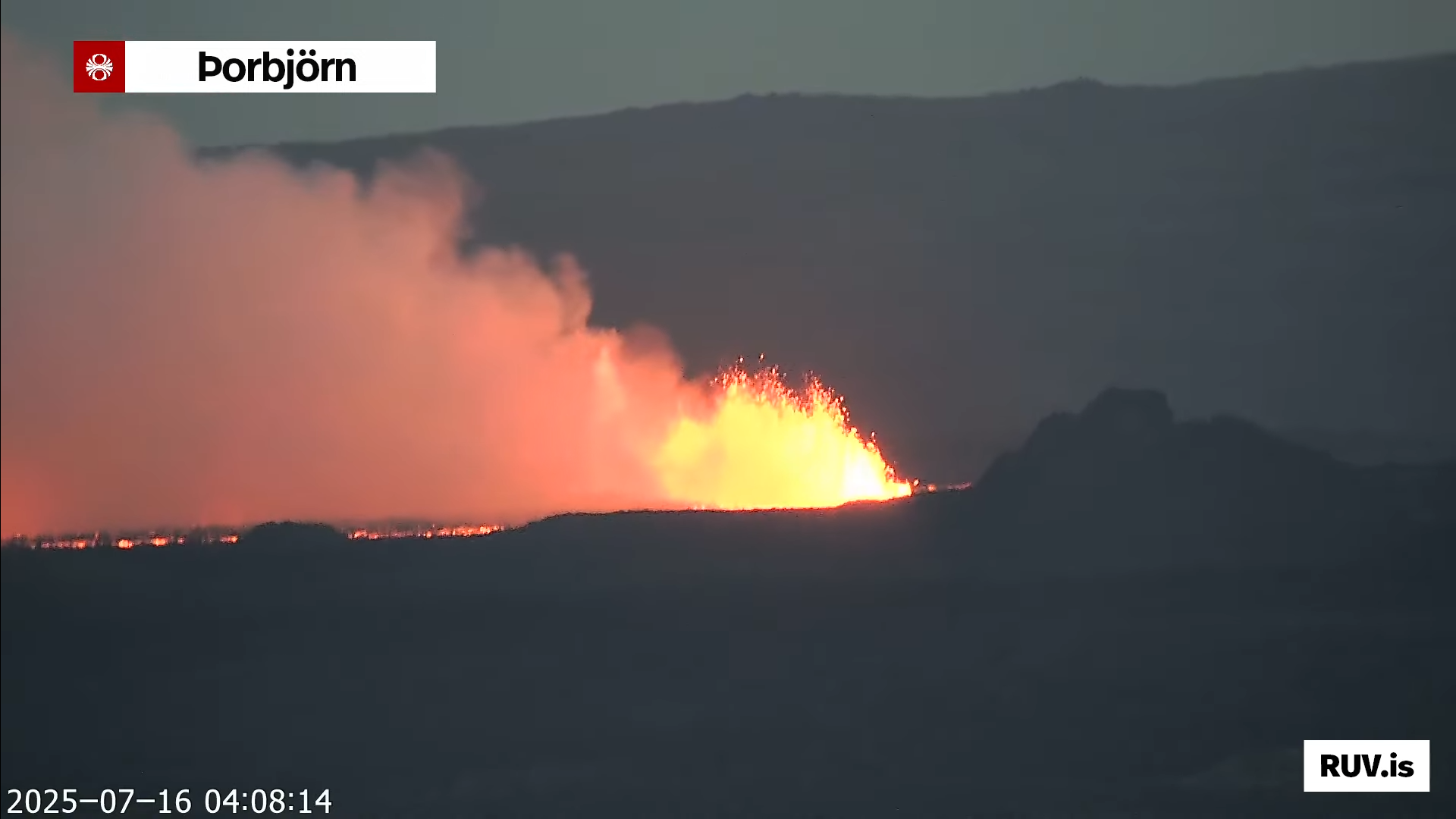
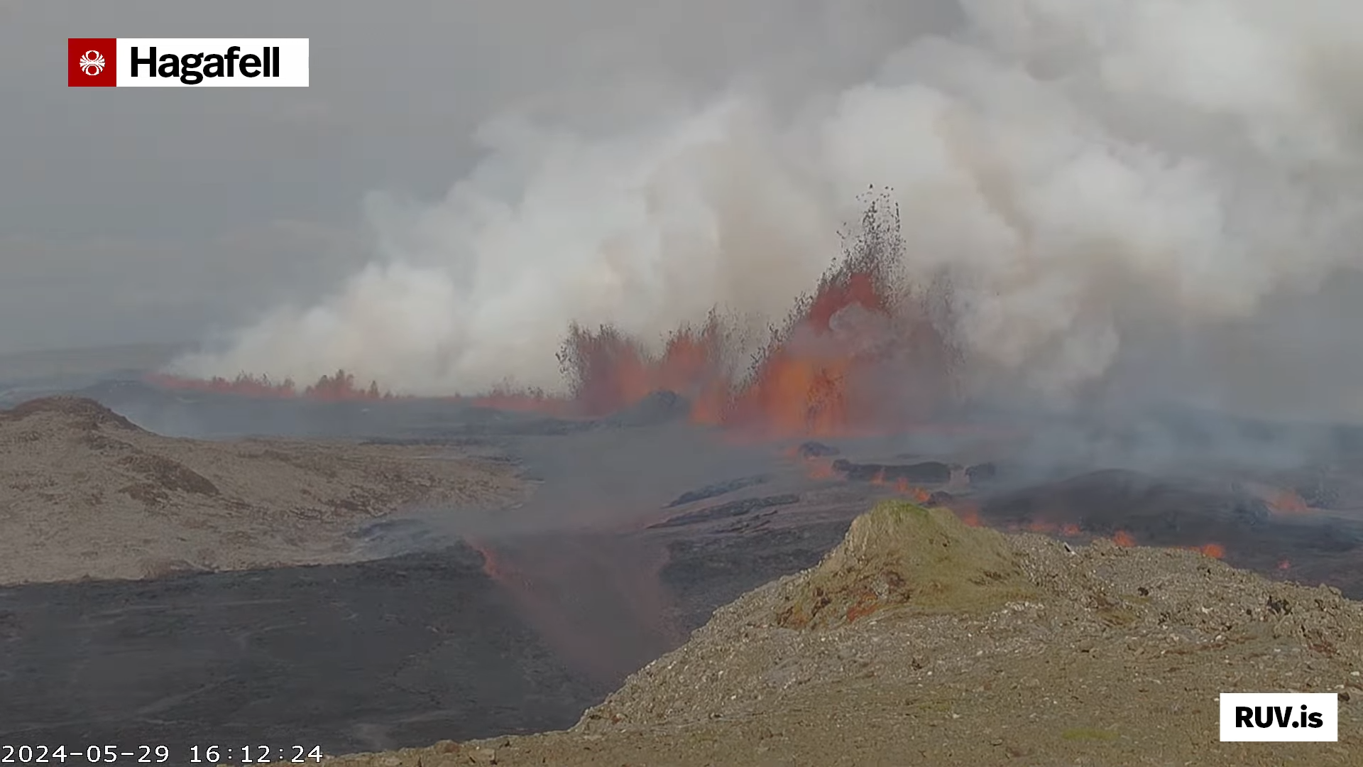
  • The eruption fissure reached 2,5 km when it was at the longest length. It has started to get smaller as the eruption has dropped in intensity over the last few hours.
  • This is the most northern eruption in Svartsengi volcano so far.
  • The lava flow is towards Fagradalsfjall volcano and into Fagradals valley and is now filling up, if it has not done so already.
  • Harmonic tremor looks stable at the writing of this article. This can change quickly and without warning.
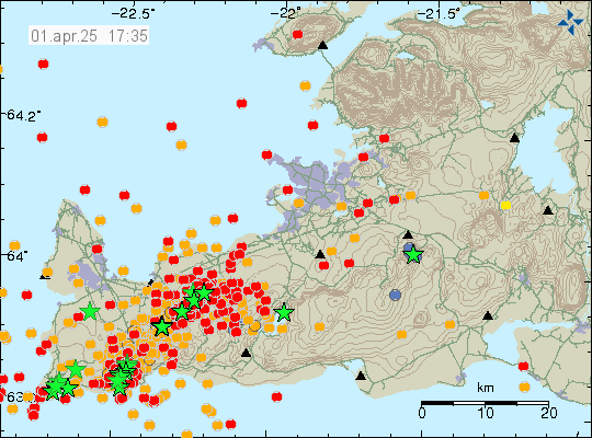
  • Early GPS data suggest that deflation of Svartsengi volcano is around 100mm for the last 12 hours where it is most. Depending on the GPS station location in the volcano system.
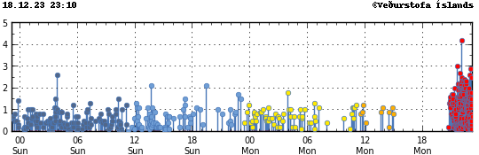
  • Earthquake activity has stopped or almost stopped in the area.
  • I don’t expect this eruption to last more than few days. However eruptions in this area sometimes continue in one crater at very low volume for a several weeks. At current time its impossible to know if that happens.
  • Fog is currently blocking all view of the eruption. So its impossible for me to know what is happening visually.
  • Gas pollution has been a problem in this eruption and wind direction. This might not improve until the eruption ends.

If there is anything more to report. I’ll post update here about it. I don’t expect there is going to be any need for any future update at the writing of this article.

Updated at 00:59 UTC on 17th of July with missing information.

Eruption has started in Sundhnúkagígaröðinni in Svartsengi volcano

Today (16-July 2025) at 03:53:31 UTC an eruption started in Svartsengi volcano in Sundhnúkagígaröðinni crater row. This is the most northern part of the eruption area. Far from anything important. The eruption fissure doesn’t look large based on what can be seen on web cameras.

The eruption as seen on the web camera Þorbjörn. The lava strokes are clearly visible and are orange red in colour.
The eruption in Sundhnúkagígaröðinni in Svartsengi volcano. Screenshot from Rúv web camera on YouTube.

It is impossible to know how long this eruption is going to last. It might be few hours and up to few days. If needed. I’ll post updates about the eruption. Normally in this type of eruption that is not required.

Strong earthquakes in Reykjanes volcano

Around 17:00 UTC today (01-April 2025) an earthquake with magnitude of Mw5,3 took place in Reykjanes volcano. This might not be earthquakes because of tension changes in the crust in this area. It is a possibility, but at the moment what is going on is unclear.

A lot of green stars showing large earthquakes in Reykjanes volcano along with all earthquake activity in Svartengi volcano.
Earthquake activity in Reykjanes volcano. Copyright of this image belongs to Icelandic Met Office.

If the earthquake activity in the Reykjanes volcano are not tension earthquakes an eruption might stat out in the ocean. That would be explosive eruption. It is too early to know if that is the case. But next few hours should show if that is the case or not. Earthquake activity is ongoing and the this situation can change quickly and without warning.

Update on the eruption in Sundhnúkagígar on 30. May 2024 at 00:49 UTC

This is a short update on the eruption in Sundhnúkagígar on 30. May 2024 at 00:49 UTC. This might be the only update on this eruption, since normally, eruptions in Sundhnúkagígar only last one to three days normally. If that happens now remains to be seen.

Yesterday (29. May 2024) at 12:46 UTC an eruption started in Sundhnúkagígar, close to a small mountain called Sýlingafell and other nearby mountains. This is also the same area that has had eruptions in recent months. This eruption was large and peaked at 2000m3/sec. Since then it has slowed down and is maybe only around 200m3/sec to 600m3/sec for now. The flow from the eruption is going to change without warning and quickly. The eruption fissure today was at the longest around 4 km long. Currently, at the writing of this article, the eruption fissure is around 1 to 2,5 km long. How long the fissure is going to change without warning.

The eruption fissure seen from Þorbjörn mountain today at 12:58:01. A large gas cloud is coming from the eruption in a day that is slight cloudy but with sun at that moment.
The eruption just as it had started. Picture from Rúv web camera.
The eruption at 12:47:48 UTC as it was starting. The lava fountains are reaching up to 70 meters up in the air and the gas cloud keeps growing.
The eruption as it was starting. The picture is from Rúv web camera.
The eruption as it was at 12:51:24. The peak lava fountains are reaching slightly more than 70 meters up in the air and the fissure is expanding to the south and north. Gas cloud is growing and drifting to the east.
The eruption at the start. Screenshot from Rúv web camera.
The eruption as it was at 16:12:24 UTC and reaching peak of its activity. I am not sure what the peak is on this image, but based on the lava flow that is going over a small hill. It was high and a strong lava flow was happening.
The most active hour in the eruption. Screenshot from Rúv web camera.

Eruption started close to Hagafell mountain (Update for Grindavík on 18. December 2023 at 23:17 UTC)

This is a short update. Information here is going to get outdated quickly.

An earthquake swarm started at 21:05 UTC in the dyke area that formed on 10. November 2023. This earthquake swarm is ongoing and seems to be connected to when the eruption fissure expands south towards Grindavík town. The eruption started at 22:17 UTC. There’s a lot of dangerous gas pollution from this eruption. Do not get close to this eruption. This is not a small tourist friendly eruption.

A lot of red dots showing the earthquake activity in the dyke and Svartsengi just before the eruption.
The earthquake activity in the dyke. Copyright of this image belongs to Icelandic Met Office.

I’ll post new article when I know more in next few hours.

Update for Grindavík on 8. December 2023

This is a short article about the situation in Grindavík. Information here might go outdated quickly without warning.

Sorry for the late update. I was updating my computer and its been more of a problem than I expected. Since I build my own computers, rather than buying already assembled computer.

Overview of the situation in Grindavík

Inflow into the dyke seems to have stopped one to two days ago. This means that it has started to cool down, since no inflow of fresh magma means it starts to form into rock. This is going to take years and in some areas decades cool all the way through. This also means that the rift valley is no longer moving as much as it was doing and in some areas has stopped completely. There is a crust instability in and around Grindavík town because of the rift valley, but this instability is now lower compared to first few days after 10. November. This might continue for years, even after all eruption activity stops few hundred years into the future.

Inflation has now reached almost the same level as 10. November, with only 50mm to go until the same level is reached. This inflation seems to be creating cracks in the ground around Svartsengi power plant. But the news was not clear on exact area of the formation of those cracks in the ground. Svartsengi, Grindavík and the area around the dyke continues to be a danger zone as defined by Icelandic Met Office.

This image shows the four danger zones around Grindavík. With zone 1 being in Svartsengi, Zone two to be north of Grindavík and zone three to be south east of Svartsengi and north of Grindavík. Zone four is Grindavík. Zone three is the most dangerous one.
The danger zones in Grindavík. Copyright of this image belongs to Icelandic Met Office.

The original image can be found here on Icelandic Met Office website.

This is not over and it is impossible to know when next sequence of events starts in Svartsengi and there is going to be little to no warning when it starts next. Icelandic Met Office has sad that at most there is going to be a two hour warning before an eruption starts, but it might even be shorter time. Making staying in Grindavík and nearby area all hours of the day a dangerous thing to do.

This is the last update until something happens in Grindavík.

Update on Grindavík for 4. December 2023

This is a short update and information here can go outdated quickly and without warning.

There has not a lot been happening in last few days. Here is a overview for the last few days.

  • Inflation continues in Svartsengi. Over the 90 day GPS data period. The inflation has reached the zero line. That means the inflation is now at the same level as it was before 25. October 2023. It still has about 100mm to go before it reaches 10. November levels and the sill broke and the magma dyke happened. But it is important that the GPS data from 2020 shows that Svartsengi lowered to 140mm below the January 2020 starting point with the GPS data.
  • The GPS data from January 2020 for Svartsengi show that total inflation in the area is around 230 to 250mm. This information can be viewed here (this is a none https link, so it might require an exception in Google Chrome or just use Mozilla Firefox). There’s a lot of GPS data on this site. Some of it show short term GPS data that are from last 12 hours daily update. Looking for the correct data image might take some time.
  • Inflation might need to reach 10. November levels before anything happens again. The dyke even on 10. November seems to have changed how things happen in Svartsengi so it is impossible to be sure what happens next.
  • While the magma collecting phase is ongoing. Things are going to be quiet with the earthquake activity in this area.
  • The rift valley, best I can see, continues to change and sink and rise. Resulting in ongoing damage to Grindavík town.
  • There’s less news about this at currently. That gives me less information on what is going on.

Next update should be by Friday 8. December, unless something happens.

Update on Grindavík for 30. November 2023

Information here might go outdated quickly and without warning. This article is written on 30. November 2023 at 23:44 UTC.

There isn’t much change happening at the moment. People are now allowed to be in Grindavík between 07:00 to 19:00 I think the time frame is. Earthquake activity is at minimum currently.

Daily update

  • Deepest hole that has been discovered so far is 25,7 meters deep. It is deeper, but at 25 meters the ground water level starts and hides the actual depth of this crack. Rúv news about this found here with pictures and videos in Icelandic.
  • New cracks and the ground continues to sink and move in most of areas of Grindavík. This is resulting in more damage to houses and streets in Grindavík town.
  • The harbour area in Grindavík has lowered 30 cm to 40 cm. That was the news two days ago. I think the harbour area continues to sink. This might be a signs of future problems if the ocean manages to flow into this area.
  • Svartsengi volcano continues to inflate at the rate from 10mm to 40mm a day. The last 24 hour inflation was around 40mm. Earlier the inflation had just been 10mm a day. Suggesting a increased flow of magma into Svartsengi volcano.

Something might start to happen around or after 9. December when the sill in Svartsengi is expected to reach the same pressure it was on 10. November when it broke the first time and emptied and created the dyke that formed under Grindavík and the nearby area.

Update on Grindavík for 28. November 2023

This is a short update for Grindavík and nearby area on 28. November 2023. This article is written at 23:22 UTC. This is a short update and information here can go outdated quickly and without warning.

Last few days have been quiet with little or few earthquakes. There have been earthquake swarm activity at times, suggesting that magma is trying to push at faster rate into the crust at Sundhnúkagígar and Sundhnúkar mountain. I don’t know what the current rate of magma inflow is.

Daily information

  • Magma continues to flow into the dyke. I don’t know how fast that rate is.
  • The dyke is wider than originally thought. This means it cools down more slowly. The dyke is widest around Sundhnúkar and Sundhnúkargígar area.
  • Eruption can start without warning in Sundhnúkar or Sundhnúkargígar and that area.
  • New cracks continue to form in Grindavík, along with sink holes and other issues that is creating.
  • Inflation at Svartsengi is around 10mm/day and up to 40mm/day. Currently, the inflation has slowed down to 10mm/day. This can change without warning.
  • Top of Keilir mountain has moved according to the news. I don’t know how much. But this is a displacement.
  • Rocks with the size of mobile homes have moved and rolled down from mountains.
  • Cracks are forming in a wide area around the dyke according to the news. Making it dangerous to travel in the area around Grindavík because of this new cracks in the ground.

The event in Grindavík and nearby area is not over. It is ongoing, this is just a quiet time period that is currently happening. This quiet time period is going to happen frequently in the Reykjanes volcano system. I don’t know why that is the case, this is the reality of what is going on.

Article updated at 23:56. I forgot to add few things.

Update on Grindavík 24. November 2023

This is a short update on the situation in Grindavík and nearby area on 24. November 2023. This article is written at 18:47 UTC.
Information in this article can go outdated without warning and quickly if something happens.

This activity has slowed down for now. This means I am going to be posting update less here, unless something changes and that can happen without warning.

Daily update

  • There is movements on cracks and new holes and cracks are opening up or appearing as the ground collapses and exposes the fissure.
  • Earthquake activity has reached a low point. This might be just for a short period of time.
  • The inflation in Svartsengi is today around 140 to 160mm from 10. November 2023. The inflation each day is around 30 to 40mm.
  • The area that is inflating in Svartsengi is larger now compared to the area that inflated before 10. November 2023. This has created a uncertainty in the GPS data as I understand the situation. The rift valley is also creating issues in the GPS data as parts of him continue to sink and are going to continue to sink and lower nearby area with it. How much that is difficult to know.
  • The event that happened on 10. November 2023 was the quickest event to happen in recorded history of Icelandic Met Office. According to their report and the news.

It is my view that the current low is just going to last for few more days, at most few weeks because of the ongoing inflation in Svartsengi. It is my view that it is going to take around 30 days until next dyke activity happens, that is around 10. December when that might happen. But the situation is changing quickly and impossible to know for sure how it develops in next few days to weeks.

If anything happens. I’ll post update soon as I can do so.