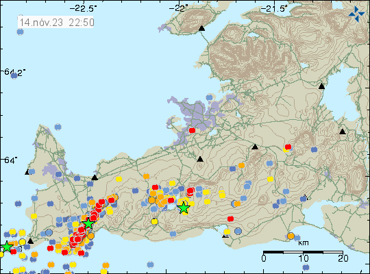
This is a short update on the situation in Grindavík and nearby area. Information here can go outdated quickly and without warning.
For the press media. Please contact Icelandic Met Office or Department of Civil Protection and Emergency Management for any important information or interviews. I already write everything I know here on this website as needed. Thanks.
- The magma is at 400 meters depth, where it is at its most shallow. I am not sure on location, but I think it is just north-east of Grindavík town.
- There is strong wind on Reykjanes peninsula. That normally hides some of the smaller earthquakes happening. Icelandic Met Office continues to record 700 to 3000 earthquakes each day. Most of them are along the dyke and most of them are in the magnitude range of Mw0,0 to Mw3,1. With the stronger ones happening least often.
- Inflow of the magma into the dyke is at the writing of this article around 73 m3/s to 75 m3/s. On Friday 10. November that inflow was 1000 m3/s.
- Sulfur dioxide was detected today north of Grindavík. That suggests that magma might be at shallow depth in the dyke area.
- News reports today did say that the area in Grindavík and nearby continues to sink around 7 cm over 24 hour time period. This might be uneven process depending on the area.
- Lakes south of Grindavík have been seen growing, as the area continues to sink and get lower. It is a question of parts of this area is going to get flooded by the ocean soon. This is reported on Facebook by Eldfjalla- og náttúruvárhópur Suðurlands.
- The GPS station just north of Grindavík has lowered by 1400mm since Friday 10. November 2023. The stations on the east are going up, some much as 1 meter. While the GPS stations on the west side are lowering.

This situation changes quickly and often from hour to hour. I’ll post new updates if something major happens, quickly as I can.
Article updated on 15. November 2023 at 00:21 UTC. – Removed information that might not be correct.

Takk fyrir þetta, Jón Frímann. Do you by chance know where we can source SO2 measurements in Grindavík? Loftgæði isn’t listing it (yet).
Also, any idea where the predictive models of lava flow could be viewed? I understand they’re circulating in information meetings but I haven’t yet spotted an online source.
I don’t know for sure. Location was not mentioned in the news. Images posted of the sensors location suggest it might be somewhere north-east of Grindavík, based on wind direction and other such factors.
Hi Jón, fine work. According to your cited Facebook page (translated into English), “[GPS] Stations east of the corridor pushed to the southeast, while west of the corridor stations moved to the northwest.” There’s a corresponding picture (with arrows showing the movement) by geophysicist Halldór Geirsson. Such lateral movement (plus affected land dropping where magma isn’t raising it) is very consistent with a tectonic tension rift spreading/splitting open (my thesis from other posts).