Update on the eruption in Sundhnúkagígar on 22. March 2024 at 03:42 UTC

This is a short update on the eruption in Sundhnúkagígar in Svartsengi volcano.

  • The eruption is now the longest eruption in Svartsengi volcano since this eruption cycle started on 18. December 2023.
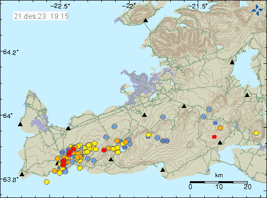
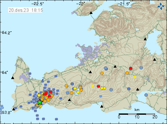
  • There are five to seven craters erupting at the writing of this article. Bad weather has blocked the view to the eruption site for most of yesterday and today (22. March 2024).
  • The outflow of lava, based on my own estimate (that might be wrong) is that the flow is around 20m3/sec. Its not a lot at the moment and that means the lava flow goes shorter distances.
  • Large lava ponds have formed and those empty regularly, resulting in a fast moving flow of lava going down to any area downhill from the eruption.
  • One person working at the be Blue Lagoon got sick from SO2 poisoning on 20. March 2024. That person did go to a hospital and is now recovering fine, according to the news.
  • A gravel mine got filled with lava yesterday (21. March 2024) when the lava pond broke and emptied it self.
  • Bad weather makes it difficult to monitor the eruption. Next good weather won’t be until Saturday (23. March 2024).
  • Early GPS data however suggest that there is not much of a deflation or inflation happening in Svartsengi volcano. That means the magma is flowing directly to the eruption and making minimal stop on the way to the surface.

This is all for now. Next update is going to be when something new happens. If this eruption is going to last for a long time. I’ll post regular updates on it. But for now, this eruption is just going to continue as is now doing.

Update on Sundhnúkagígar activity on 21. December 2023 at 18:47 UTC

This is a short article, written on 21. December 2023 at 18:47 UTC. Information here might go outdated quickly and without warning.

The eruption that started on 18. December 2023 at 22:17 UTC is over, best I can see. This was large eruption, but a short one. Total lava flow covered an area of 3,7 km2 (square kilometre). Most of the eruption happened in the first 24 – 48 hours of the eruption. There are early indicators that inflation has resumed in Svartsengi volcano, if it inflates at the same rate as before this eruption it is only going to take 8 to 10 days until next eruption. This is a big question since there’s a lot of magma in Svartsengi volcano and that magma can move towards the surface, even if the inflation doesn’t happen and can result in a larger eruption. If that happens is a wait and see situation.

Videos from the eruption areas show a lot of degaussing in the eruption fissure. This is interesting and I am not sure why that is. There’s a chance a lot of magma is in the dyke that is just releasing gas into the air without having the energy to erupt. There’s a small chance that a new eruption might happen in the same location. If that happens is impossible to know.

Red dots and yellow dots in the rift zone valley where the eruption just ended. Time on image is 21. Des. 2023 at 19:15 UTC.
Earthquake activity along the rift valley. Copyright of this image belongs to Icelandic Met Office.

This earthquake activity is interesting, it started yesterday (20. December 2023). This follows the same pattern as the earthquake activity before the start of the eruption on 18. December. If that is what is happening remains a wait and see situation for now.

This is the last update unless something happens in this area. Based on current information, that is what is going to happen, the question is just when.

Update for Sundhnúkagígar eruption on 20. December 2023 at 18:29 UTC

This is a short update and information here might go outdated quickly and without warning.

This eruption is a short one and that’s how eruptions in Iceland are normally. This eruption might end by Friday to Monday, depending on what happens.

  • The flow from the craters that are erupting is around 10m3/sec. This is low compared to the start of the eruption on Monday 18. December 2023 and suggest that this eruption is going to end soon.
  • GPS data shows that Svartsengi volcano has only lowered around 80mm since Monday. This means there’s a lot of lava in Svartsengi for new eruptions to happen without much warning.
  • Earthquake activity along the fault valley has resumed, after stopping soon after the main eruption took place. This is interesting and I am unclear what this means at the writing of this article.
  • Icelandic Met Office is reporting that the eruption, even is small, is stable at the writing of this article. This can change without warning.
  • The lava field is now, according to best measurements around 3,7 km2 (square kilometres).
  • According to University of Iceland Earth science department, the chemical makeup of the lava shows that its more evolved in part than the lava in Fagradalsfjall volcano. This can be read here (new link, now in English). This means that this magma stopped on its way to the surface and cooled a little and changed chemical makeup before erupting.
  • This new lava is different than the lava that erupted 2400 years ago at the same location. Why that is I don’t know. It is going to take few years to maybe get an answer to this question when the experts have done their research and published their science papers.
Earthquake activity along the rift valley in Svartsengi volcano shown by a green stars, red and orange dots showing smaller earthquakes.
Earthquake activity along the rift valley. Copyright of this image belongs to Icelandic Met Office.

It is interesting to see that Þorbjörn mountain continues to get lower, based on GPS data from today (20. December 2023). Icelandic Met Office has released new danger map and that can be found here in English on Icelandic Met Office website.

This is all the information I know of today (20. December 2023). Next article should be tomorrow (21. December), unless something happens then I’ll try and write article soon as I can.

Update on the eruption in Sundhnúkagígar on 19. December 2023 at 21:46 UTC

This is a short update and information here might go outdated quickly. This article is written on 19. December 2023 at 21:46 UTC.

I am trying to collect and read all the information I can find. I don’t have access to everything my self, so I am depended on news and reports from Icelandic Met Office and others on what is happening in this eruptions. This is not unusual and has always been like this.

  • The eruption is now in 2 to 4 vents. I am little unclear at the writing of this article now many are erupting.
  • The new dyke seems to go into the dyke from 10. November. This can result in reactivation of the dyke from 10. November and result in an eruption along it, all 15 km at random location.
  • Current flow seems be around 50m3/sec at the writing of this article. I’ve been hearing that highest flow yesterday (18. December) was around 800m3/sec, but that number is for me unconfirmed. It dropped to 100 – 500m3/sec soon after the eruption started.
  • Early GPS data from today seems to suggest that Svartsengi volcano has lowered about 50mm since the start of the eruption. I am waiting for new GPS data on Icelandic Met Office website. That data hopefully shows up tomorrow (20. December).

There’s a lot of uncertain things that can happen with this eruption at the moment. Since there’s a lot of lava in Svartsengi volcano that has not erupted so far. New inflow of lava from the deep mantle is also a possibility and those can happen without warning as the pressure drops in Svartsengi volcano sill (or magma chamber).

I’ll post next update tomorrow (20. December 2023) or sooner if anything happens.

Update on the eruption at Sundhnúkagíga on 19. December 2023 at 16:10 UTC

This article is short and is written at 16:10 UTC on 19. December 2023. Information here can go outdated quickly and without warning.

There has been a reduction in the eruption since it started at 22:17 UTC on 18. December 2023. This was to be expected. Since the eruption seems to be coming from a small sill in Svartsengi volcano, rather than a large magma chamber.

  • The eruption is now limited to three to four eruption vents. The largest one is where the eruption started. Crater building is ongoing.
  • The lava is flowing towards Fagradalsfjall volcano (mountain) at the writing of this article. This area is empty, outside of the the parking lots south of Fagradalsfjall. They are not at risk for now.
  • The problem with eruptions of this type is that they can grow again in size if different sill breaks and starts flowing into the established flow channels that magma is now flowing and creating the eruption. If that happens is impossible to know. This can also result in a eruption that goes on for a long time. If that happens, an lava might end up reaching far away areas.
  • It is going to take few days for GPS data to show what sill is deflating in Svartsengi volcano and what is going on in the crust in Svartsengi volcano.
  • Weather might be a problem for next few days on Reykjanes peninsula.
  • This area is not to hike around on. Its dangerous and the weather makes difficult walk extremely difficult.  Just watch the online web cameras.
  • The lava field is large and it creates its own strong wind as the lava warms up the air around it. That can be difficult to deal with in the snow for anyone close the the eruption.

The dyke is longer than the part that erupted according to the news and measurements. The dyke is more south and it ends just 1,5 km north of Grindavík town. That area can erupt without warning if pressure starts to build up in that part of the dyke. That same goes for the north part of the dyke, how far more north the dyke is I don’t know.

I’ll post next update when I have more information what is going on or sooner if anything happens.

Update on Grindavík for Wednesday 22. November 2023

This is a short update. Information there might go outdated quickly and without warning. This article is written on Wednesday 22. November 2023 at 21:32 UTC.

There’s little news to report at this moment. Mostly because of bad weather. The progress of the dyke has also stalled from earlier, or this might be it for now. It is difficult be sure currently.

Risk map of Grindavík and the total of 15 km in both directions. The red zone, danger zone b has been withdrawn to north of Grindavík and now its just a small line north of the town and up north along the dyke. The most dangerous risk zone is north of the town.
The risk zone around Grindavík. Copyright of this image belongs to Icelandic Met Office.

The inflation at Svartsengi (upwards movement) stopped in the last 24 hours. This either means this series of events is stopping for now or something major is about to happen. I am not sure. Risk of this being a error are small, but this might be interference from weather (rain, snow).

The air code for Reykjanes volcano has been downgraded to yellow.

Aviation colour code for volcanoes in Iceland. All are green except Reykjanes volcano that is now yellow.
The aviation colour code of volcanoes in Iceland. Copyright of this image belongs to Icelandic Met Office.

The situation in Grindavík and in Sundhnúkagígar and the nearby area can still change without much warning. Since the ground is very fractured there and is not going to be much resistance to any magma movements in the near future.

If anything more happens. I’ll update soon as I can.

Update for Grindavík on Monday, 20. November 2023

This is a short update on the situation in Grindavík. This article is written on 20. November 2023 at 22:22 UTC.

Storm warning

There’s a storm in Iceland until 23. November 2023. When the wind is going to start die down again. This means that Icelandic Met Office is going to record fewer earthquakes because strong ocean waves and wind.

Daily update

  • There has not been much change since yesterday. This is normal.
  • Inflation in Svartsengi is up to 30mm/day and this is a increase, since inflation used to be around 15mm/day.
  • Since Friday 10. November 2023 the inflation in Svartsengi has been around 150mm over the last 11 day time period.
  • It took 17 days from start on October 25 of the magma inflow into the Svartsengi dyke until it broke on 10. November and the created the Sundhnúkar to Grindavík dyke.
  • It is a question what happens when next 17 days come up. Because whatever the hold is for the magma in the dyke in Svartsengi is going to break it is going to start the process as happened on 10. November 2023 and possibly into the current dyke, or possibly create a new dyke next to the current one (its a possibility, not a large one, but it is there).

Other updates

There has not been a lot of information released today and I don’t see a lot on seismometers and other instruments around Grindavík town currently.

This is a image of the danger zone around Grindavík and north of it. Its divided into three zones. With the colours orange, red, purple.
The current danger zone map from Icelandic Met Office. Zone A (orange) is the least dangerous area. Zone B (Red) is a dangerous zone, risk of fissures opening up, erupting crates, lava flows and gas pollution. Zone C (purple) is the most dangerous zone, Its close to same as zone b, but increased risk of dangerous volcano gases and entering it requires wearing a gas mask, have a gas and have gas measurement tool when going into the zone. Red dotted line is the estimated location of the dyke. This map also shows fissures in this area and the rift valley. Copyright of this image belongs to Icelandic Met Office.

This type of quiet period before an eruption are common. Why is not well understood. Eruption might not happen, but it is not likely that nothing is going to happen in this. Both is magma too close too the surface and there’s too much inflow of magma into the dyke at Svartsengi. This is how I see the current situation.

If anything happens. I’ll post update soon as I can.

Update on Grindavík on 19. November 2023

This is a short update on the activity in Grindavík on 19. November 2023. Information here might go out of date without warning. This article is written at 22:28 UTC.

Krýsuvík earthquake

This morning an earthquake with magnitude of Mw3,7 took place in Krýsuvík-Trölladyngja volcano. This earthquake was felt in Reykjavík area. This earthquake happens because of all the displacement that is now happening next to Grindavík town.

Green star west of Kleifarvatn lake. The dyke appears as a red line with a lot of smaller earthquakes.
The earthquake activity in Krýsuvík-Trölladynga volcano. Copyright of this image belongs to Icelandic Met Office.

Daily update

This is also an update for 18. November 2023. I was trying to get a little time off from writing.

  • Little has changed in last two days. Parts of Grindavík town continue to sink or rise depending on location. Most measured movements is around 25 cm last I did see. If that is correct today I am not sure.
  • Inflation in Svartsengi is around 130mm since Friday 10. November 2023 according to GPS measurements and satellite measurements.
  • Inflow of magma into Svartsengi is estimated to be around 50m3/sec when this article is written according to the news. Inflow of magma into the dyke was 75m3/sec or more few days ago. That has possibly changed to a lower number in last few days.
  • Earthquake activity remains about the same in the dyke. Around 800 to 2000 earthquakes a day along the 15 km long dyke.
Image that shows inflation in Svartsengi area on Reykjanes peninsula. This is a red area that has been lifting up 30mm/day. The image shows also colour blue and green. With blue showing area lowering and green and yellow area uplifting.
Inflation on the Reykjanes peninsula. Copyright of this image belongs to Icelandic Met Office.

It is impossible to know when this area is going to erupt. It can take up to three to four weeks to happen. It might be a shorter time period, it is impossible to know what happens when it comes to volcanoes and dyke activity.

If anything happens. I’ll post an update quickly as I can.

Update on Grindavík 17. November 2023

This is a short update on the situation in Grindavík on 17. November 2023. Information here can go outdated quickly and without warning.

Daily updates

  • Grindavík town continues to sink as the rift valley continues to move. The speed of sinking has slowed a little according to the news today.
  • Earthquake activity has slowed down in last few hours (this is written around 22:51 UTC). What that means is unclear.
  • Some houses in Grindavík town have been completely destroyed. Iceland has a natural disaster fund for this type of situation and that is going to cover the owners loss according to the news.

General update

It took me a week. But it seems that this dyke intrusion under Grindavík town is because of the magma sill (dyke) under Svartsengi. That area has inflated around 110mm in a week. That is a inflation of 15mm/day based on my best calculations. That is a lot of inflation, since before 10. November the inflow of magma into Svartsengi was at most 8m3/sec according to measurements of Icelandic Met Office.

The sill in Svartsengi created a lateral dyke in Sundhnúkar and nearby areas. When the pressure in the sill is high enough again it is going to push the magma into the dyke at Sundhnúkar again with the same force as it did before. How long that takes I don’t know. Last time this was from 25. October to 10. November. That’s seventeen days, but there was a lot of deeper sills in Svartsengi and its impossible to know much, if anything flowed form them into the dyke. This is my personal view, it might be wrong. But this is what I am reading from the data.

Risk of the eruption remains high because there’s a ongoing inflation at Svartsengi. When a eruption starts is impossible to know.

If anything happens. I’ll post update soon as I can.

Update on Grindavík on 16. November 2023

This is a short update on what is happening in Grindavík on 16. November 2023. Information here can go outdated quickly and without warning.

The situation is mostly the same as yesterday (15. November 2023), but few things have happened and that is enough for me to publish this article.

  • Sulfur dioxide has been detected in a drilling hole in Svartsengi. This drilling hole is such that it end point is close to Hagafell mountain  east to Svartsengi power plant. I think this might be a cold water hole. It has a depth of 2,5 km. This means that magma is at or close to that depth. Ground water in this area doesn’t go deeper than 1,9 to 3 km I think (I am not sure on how the fresh water ground level works in this area).
  • Eruption is expected from hours to day based on most recent measurements from Icelandic Met Office.
  • Grindavík town continues to sink according to news today (16. November 2023). Difference between days can be as much as 25 cm.
  • Mbl.is (Morgunblaðið) has a video of the damage done by this sinking on their website here. Its in Icelandic.

The situation for now is quiet, but that might only last for few hours to days longer before an eruption starts. Since earthquake activity strongly suggests that magma is looking for a way to the surface. While some magma is at shallow depth of 400 to 500 meters. There’s not enough of it to start an eruption. That can change without any warning at any time in this situation.

I’ll write updates if anything more happens here as quickly as I can.