This is a short update since there has not been a lot of change in the last twenty four hours.
The eruption is stable at the writing of this article. This might change without warning.
Harmonic tremor has been stable in the last 24 hours. With almost no fluctuation.
GPS stations around Svartsengi volcano show a deflation around 200 to 300mm at the writing of this article. There’s uncertainty in this data because of bad weather in Iceland.
The lava from this eruption has reached 5,85 km2 according to Icelandic Met Office.
There is little to no earthquake activity in this area, but measurements might be blocked by bad weather.
Crater build up continues in this eruption.
The lava is around 350 meters from Suðurstrandarvegi and around 700 meters from reaching out in the ocean.
If there is a change in the eruption. I’ll write about it quickly as I can. Next article should be by 21. March 2024 if the eruption is still ongoing by that date.
I am sorry for slow updates. All this activity and eruptions keeps me busy with many things. I also needed a little break from writing articles.
According to Icelandic Met Office and what I’ve been seeing on GPS data from around Svartsengi volcano an eruption is expected possibly next week, it might happen earlier or later, there’s no way to be sure on this. But the inflation has reached the same level just before the eruption on 8. February 2024. What is going to happen in next eruption is impossible to know, until the eruption starts. There is ongoing risk that next eruption is going to happen closer to Grindavík town and not in Sundahnúkagígar area as the eruption on 8. February 2024 took place.
At the current rate, there’s going to be an eruption in Sundhnúkagígar area every 30 or so days until something changes. When that happens is impossible to know. This 30 day eruption cycle might go on for a long time, even many years.
This is a short update on the eruption at Sundhnúkagígar.
Four hour GPS data shows that inflation has already started in Svartsengi volcano, that is currently erupting. This inflation seems to have started soon as the eruption started to get lower around 13:00 UTC.
The lava flow damaged the hot water pipe from Svartsengi power plant and now around 26.000 people on the Reykjanes peninsula are without hot water. There is also some damage to the power infrastructure, but that is minimal and that power has been restored on the power lines that are next to the lava flow. The situation on the cold water is unclear, but it was at risk of damage.
This eruption was larger compared to the eruptions on 18. December 2023 and on 14. January 2024.
Small ash cloud formed today and the reason for that, according to experts in the news. Was that the eruption in part of the fissured ended so suddenly with a pressure drop that the fissure walls collapsed, allow ground to get in touch with lava and then ground water started to flow on the lava. Resulting in two clouds, one dark and a steam cloud. This was large for an about hour or two. Steam cloud was ongoing at writing of this article, but darkness prevents me from seeing if this has stopped. It is likely though.
The eruption is ongoing in two to three craters at the writing of this article.
It is expected, based on current rate of how much the eruption is slowing down that it is going to end tomorrow, 9. February or on 10. February.
Next eruption is going to be in March around 6th to 18th March if current pattern holds for Svartsengi volcano. There’s nothing to rule out that a new eruption might happen sooner. It is impossible to know what happens next in Svartsengi volcano eruptions.
If anything more happens. I’ll post update soon as I can.
This update is going to be short. Information here might go outdated quickly and without warning. This article is written at 20:51 UTC on 2. January 2024.
Inflation in Svartsengi volcano has reached its maximum according to GPS stations compared to 18. December 2023. This inflation is not even among the GPS stations on top of Svartsengi volcano. Why that is unclear, but most likely reason is that the sills that are in Svartsengi volcano are not evenly filled this time around. Why that is I don’t know, something must have changed in the internal flow of this volcano when it comes to the sills.
It is difficult to know when next eruption happens, at the writing of this article I am looking at around seven day window at the moment. That an eruption should happen around 9. January 2024. It might happen sooner or it might happen later. It is difficult to know for sure. Where eruption is going to happen is impossible to know. It is expected that an eruption might happen again close to the last eruption took place or at the same location.
If anything happens. I’ll post update soon as possible. Next update for Sundhnúkagíga is going to be when something happens.
Donations
I no longer have Google Adsense, because it was no longer economic to use them. Because of new requirements and lower advertising income, that has been going down for a while (this is also happening on YouTube for people that create content there, they have videos on this). If people want to support my work, they can do so with a bank transfer, both inside and outside of Europe. That is the most safe option. The second option is to use PayPal, with all its problems and issue that might happen. Thanks for the support. 🙂
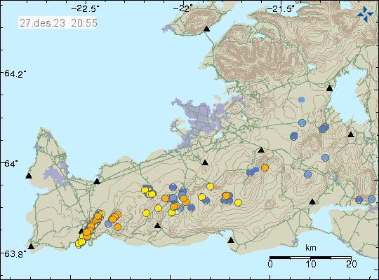
This is a short update on the situation in Sundhnúkagíga on 27. December 2023 at 20:40 UTC. Information here can go outdated without warning and quickly.
There’s inflation taking place in Svartsengi volcano. At current rate this inflation is around 10mm a day. This means that earliest an eruption might happen is around 30. December 2023 in my view. But it might happen as late as 10. January 2024. This inflation is really quick, but since last eruption only lowered Svartsengi volcano only around 80mm, the inflow of magma has less space to fill up before a critical point is reached in the crust in Sundhnúkagígaröðin area. This also means it takes shorter time for this to happen.
Earthquake activity along the dyke that was created on 10. November 2023 and in Fagradalsfjall volcano. Copyright of this image belongs to Icelandic Met Office.
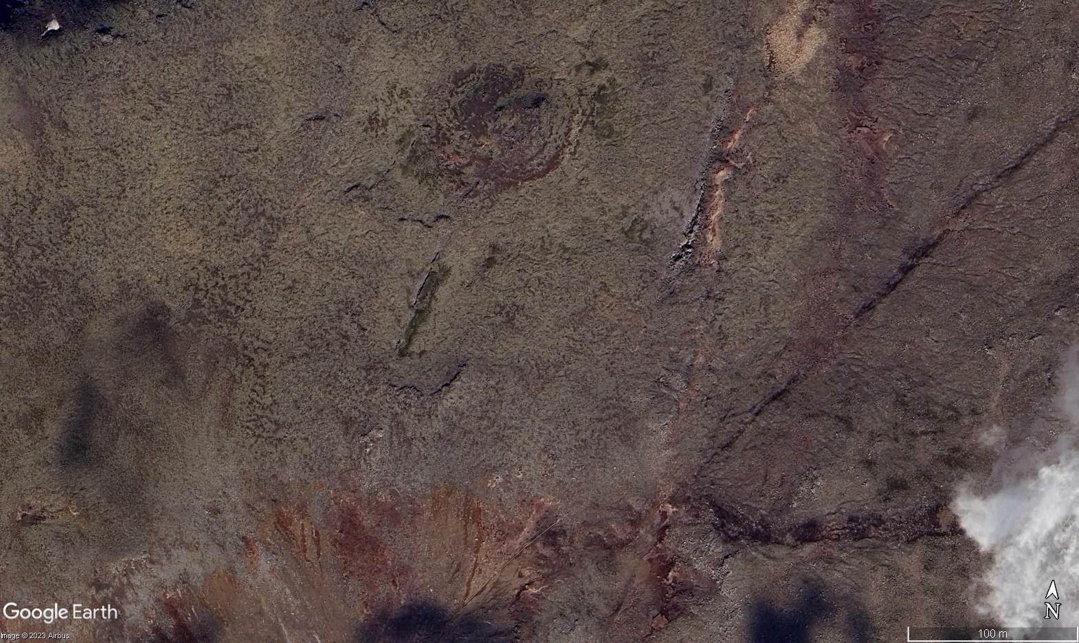
There’s also activity in Fagradalsfjall volcano. This is along a fault line that I don’t think has been active like this before. Why is unclear, but this might be an early sign that this fault in Fagradalsfjall volcano might erupt in the future. Since Fagradalsfjall volcano is on around ten month eruption cycle, this fault might erupt sometimes between May to September 2024. I am sure that this is going to get more clear as the time goes on if anything is going to happen in Fagradalsfjall volcano. Satellite images from Google Earth do show a clear fault in along the earthquake active area. This is possibly a known fault, but I do not have any information about that as is.
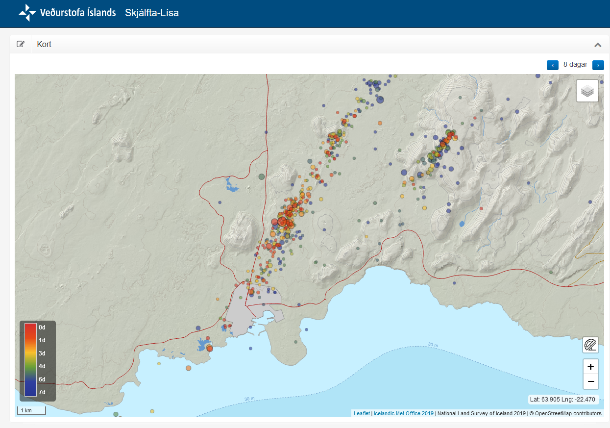
Earthquake activity for the last 8 days in Sundhnúkagígaröðin and in Fagradalsfjalli. Image from Skjálfta-Lísa. Copyright of image belongs to Icelandic Met Office.Crack in the ground on Google Earth image of Fagradalsfjall volcano. Copyright of this image belongs to Alphabet/Google Earth.
It is impossible to know what happens in Fagradalsfjall volcano and in Svartsengi volcano. This situation can change quickly and without warning. It can change so quickly that I might not be able to update about it quickly enough if this happens at a time when I am outside doing something else.
If anything happens. I’ll update soon as I can do so. Next update should be on 2. January 2024 if this remains quiet.
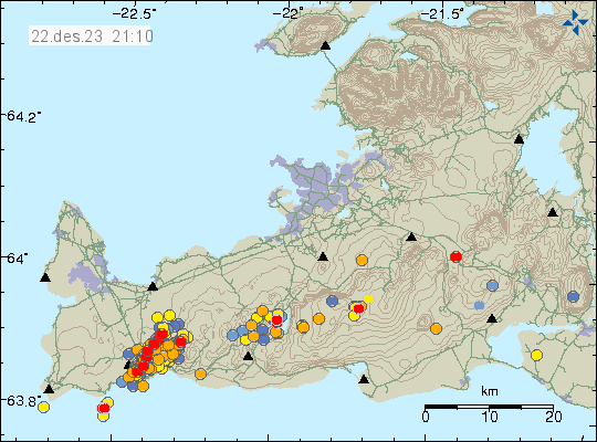
This is a short update and information here might go outdated quickly and without warning. This update is written on 22. December 2023 at 20:50 UTC.
Inflation has resumed in Svartsengi volcano. It also seems that inflation started again just before the eruption ended in Sundhnúkagaígar. At the writing of this article, the inflation is only around 5mm to 8mm a day. That is fast, by any standard, but still lower than before the eruption when inflation was around 10mm a day. There seems to be a slowdown of inflation before an eruption happens and a new dyke creations. Not all dyke that are going to happen are going to end in a eruption, maybe, since the magma has only limited space to expand into in the rift valley, because of the dyke that was created on 10. November 2023.
Earthquake activity along the rift valley today. This is a lot of earthquake activity. Copyright of this image belongs to Icelandic Met Office.
Earthquake activity along the rift valley increased quickly as the eruption that started on 18. December 2023 started to slow down. That means the magma in Svartsengi volcano is trying to find a way out and erupt all at once, or close to that in my personal view. The 4,1 km long fissure that erupted last time doesn’t seems to have been a enough for the pressure that is in the volcano at the writing of this article. That is interesting but might also be a clue that things are about to get really dangerous in this area. I also don’t know if this is going to happen, because clues are one thing and reality is a different thing.
If anything happens. I am going to write an article soon as I can.
This is a short update and information here might go outdated quickly and without warning.
This eruption is a short one and that’s how eruptions in Iceland are normally. This eruption might end by Friday to Monday, depending on what happens.
The flow from the craters that are erupting is around 10m3/sec. This is low compared to the start of the eruption on Monday 18. December 2023 and suggest that this eruption is going to end soon.
GPS data shows that Svartsengi volcano has only lowered around 80mm since Monday. This means there’s a lot of lava in Svartsengi for new eruptions to happen without much warning.
Earthquake activity along the fault valley has resumed, after stopping soon after the main eruption took place. This is interesting and I am unclear what this means at the writing of this article.
Icelandic Met Office is reporting that the eruption, even is small, is stable at the writing of this article. This can change without warning.
The lava field is now, according to best measurements around 3,7 km2 (square kilometres).
According to University of Iceland Earth science department, the chemical makeup of the lava shows that its more evolved in part than the lava in Fagradalsfjall volcano. This can be read here (new link, now in English). This means that this magma stopped on its way to the surface and cooled a little and changed chemical makeup before erupting.
This new lava is different than the lava that erupted 2400 years ago at the same location. Why that is I don’t know. It is going to take few years to maybe get an answer to this question when the experts have done their research and published their science papers.
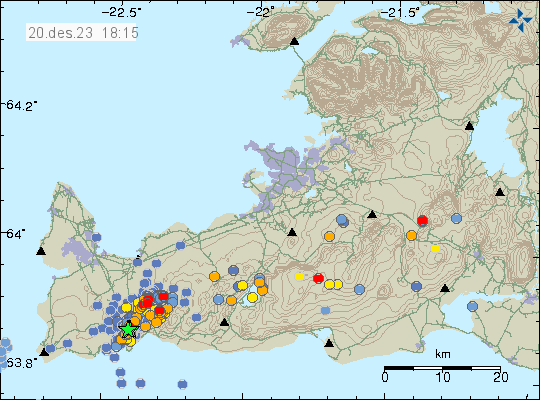
Earthquake activity along the rift valley. Copyright of this image belongs to Icelandic Met Office.
It is interesting to see that Þorbjörn mountain continues to get lower, based on GPS data from today (20. December 2023). Icelandic Met Office has released new danger map and that can be found here in English on Icelandic Met Office website.
This is all the information I know of today (20. December 2023). Next article should be tomorrow (21. December), unless something happens then I’ll try and write article soon as I can.
This information is unclear, but this is the best information I have at the writing of this article.
It seems that Svartsengi volcano has reached close or the same level as 10. November levels. There has been a slight shift where the inflation has been happening. It seems to have moved slight closer towards Þorbjörn mountain, that also means the main inflation is happening closer to Sundhnúkar and Sundhnúkargígar and Sýrlingafell mountain. This strongly suggest that magma is building up in this area because of the ongoing weakness in the crust in this area. This also strongly suggests that when the magma in this sill goes next on the move, it is going to go up towards Sundhnúkar and Sundhnúkagígar area and into the dyke that formed on 10. November 2023. That dyke has filled up all available space created by the rift valley, next dyke is more likely to start an eruption than the dyke created on 10. November.
There’s no earthquake activity in Svartsengi volcano at the moment, until that happen, the volcano is quiet at the writing of this article. It is more than likely that an strong earthquake swarm is going to start in Svartsengi volcano and close to Sundhnúkar and Sundhnúkagígar once the magma gets moving again. Inflation in a volcano does not always result in increased earthquake activity, since this depends slightly on what has been happening and how the crust is in that volcano at that time when activity is ongoing. It is impossible to know when next activity starts in Svartsengi volcano, but there is a chance that the magma that has flowed into the sill needs a time to change before it moves again. That can take time, how long is difficult to know, but this might be from six months and up to two years at most. This depends on the magma flowing in, gas content and such, so it can happen both slower and faster than earlier inflow of magma into the sill in Svartsengi volcano.
At the writing of this article. Everything is quiet in Svartsengi volcano.
This is a short article about the situation in Grindavík. Information here might go outdated quickly without warning.
Sorry for the late update. I was updating my computer and its been more of a problem than I expected. Since I build my own computers, rather than buying already assembled computer.
Overview of the situation in Grindavík
Inflow into the dyke seems to have stopped one to two days ago. This means that it has started to cool down, since no inflow of fresh magma means it starts to form into rock. This is going to take years and in some areas decades cool all the way through. This also means that the rift valley is no longer moving as much as it was doing and in some areas has stopped completely. There is a crust instability in and around Grindavík town because of the rift valley, but this instability is now lower compared to first few days after 10. November. This might continue for years, even after all eruption activity stops few hundred years into the future.
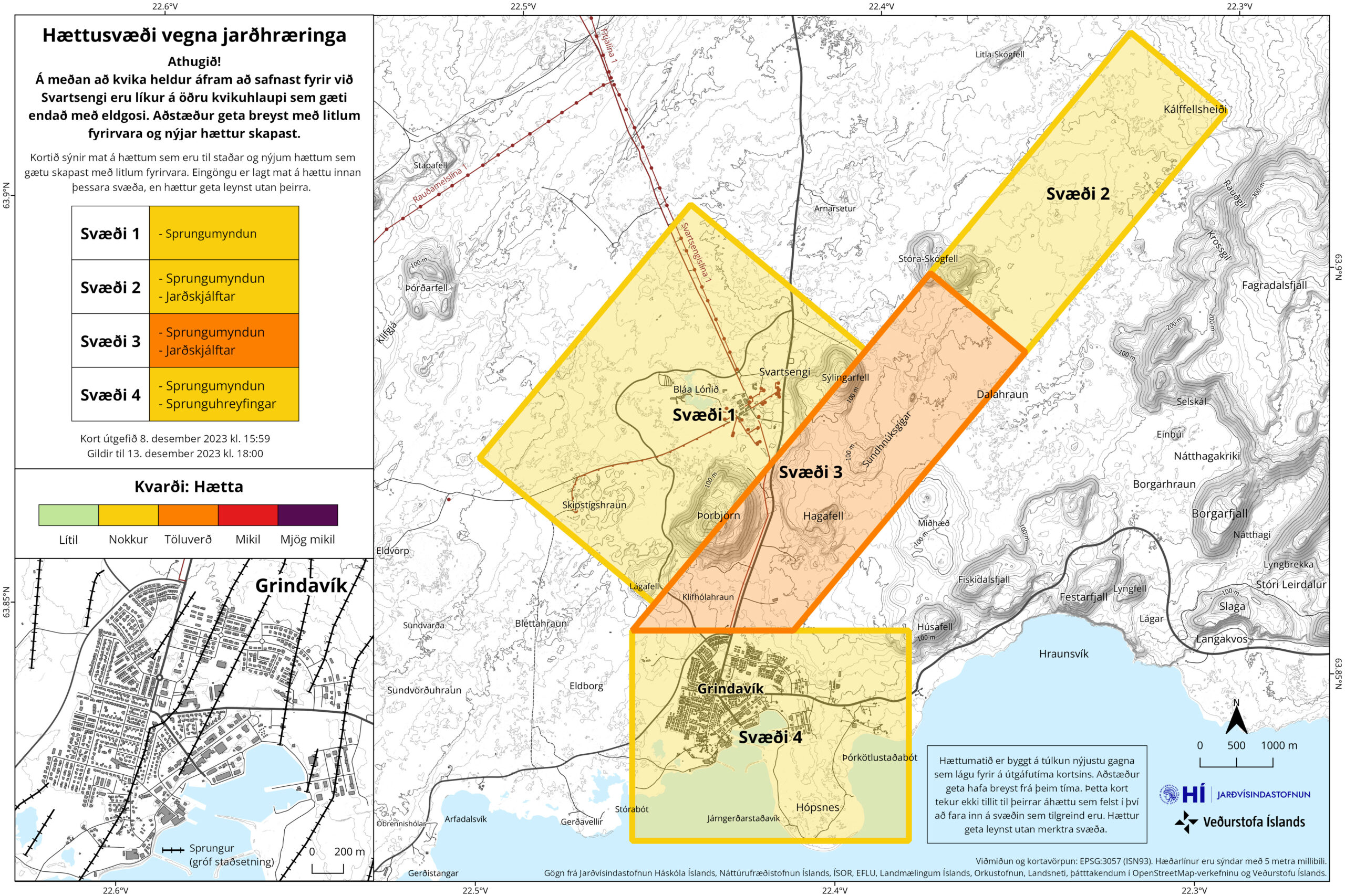
Inflation has now reached almost the same level as 10. November, with only 50mm to go until the same level is reached. This inflation seems to be creating cracks in the ground around Svartsengi power plant. But the news was not clear on exact area of the formation of those cracks in the ground. Svartsengi, Grindavík and the area around the dyke continues to be a danger zone as defined by Icelandic Met Office.
The danger zones in Grindavík. Copyright of this image belongs to Icelandic Met Office.
The original image can be found here on Icelandic Met Office website.
This is not over and it is impossible to know when next sequence of events starts in Svartsengi and there is going to be little to no warning when it starts next. Icelandic Met Office has sad that at most there is going to be a two hour warning before an eruption starts, but it might even be shorter time. Making staying in Grindavík and nearby area all hours of the day a dangerous thing to do.
This is the last update until something happens in Grindavík.
This is a short update and information here can go outdated quickly and without warning.
There has not a lot been happening in last few days. Here is a overview for the last few days.
Inflation continues in Svartsengi. Over the 90 day GPS data period. The inflation has reached the zero line. That means the inflation is now at the same level as it was before 25. October 2023. It still has about 100mm to go before it reaches 10. November levels and the sill broke and the magma dyke happened. But it is important that the GPS data from 2020 shows that Svartsengi lowered to 140mm below the January 2020 starting point with the GPS data.
The GPS data from January 2020 for Svartsengi show that total inflation in the area is around 230 to 250mm. This information can be viewed here (this is a none https link, so it might require an exception in Google Chrome or just use Mozilla Firefox). There’s a lot of GPS data on this site. Some of it show short term GPS data that are from last 12 hours daily update. Looking for the correct data image might take some time.
Inflation might need to reach 10. November levels before anything happens again. The dyke even on 10. November seems to have changed how things happen in Svartsengi so it is impossible to be sure what happens next.
While the magma collecting phase is ongoing. Things are going to be quiet with the earthquake activity in this area.
The rift valley, best I can see, continues to change and sink and rise. Resulting in ongoing damage to Grindavík town.
There’s less news about this at currently. That gives me less information on what is going on.
Next update should be by Friday 8. December, unless something happens.