
This is a short update, since the situation is changing quickly and without much warning. This just looks like it is quiet, it is not.
- Grindavík town is sinking and parts of the town have lowered by as much 1 meter when this article is written. This is a large area, large enough to be called rift valley. This was reported by mbl.is here in Icelandic. This was just discovered today when some measurements where taken.
- Magma might be as shallow as few dozen meters under the surface where it is the most shallow. This has been reported by mbl.is here in Icelandic. This is a live link and the news item in question might be removed or gone in few hours.
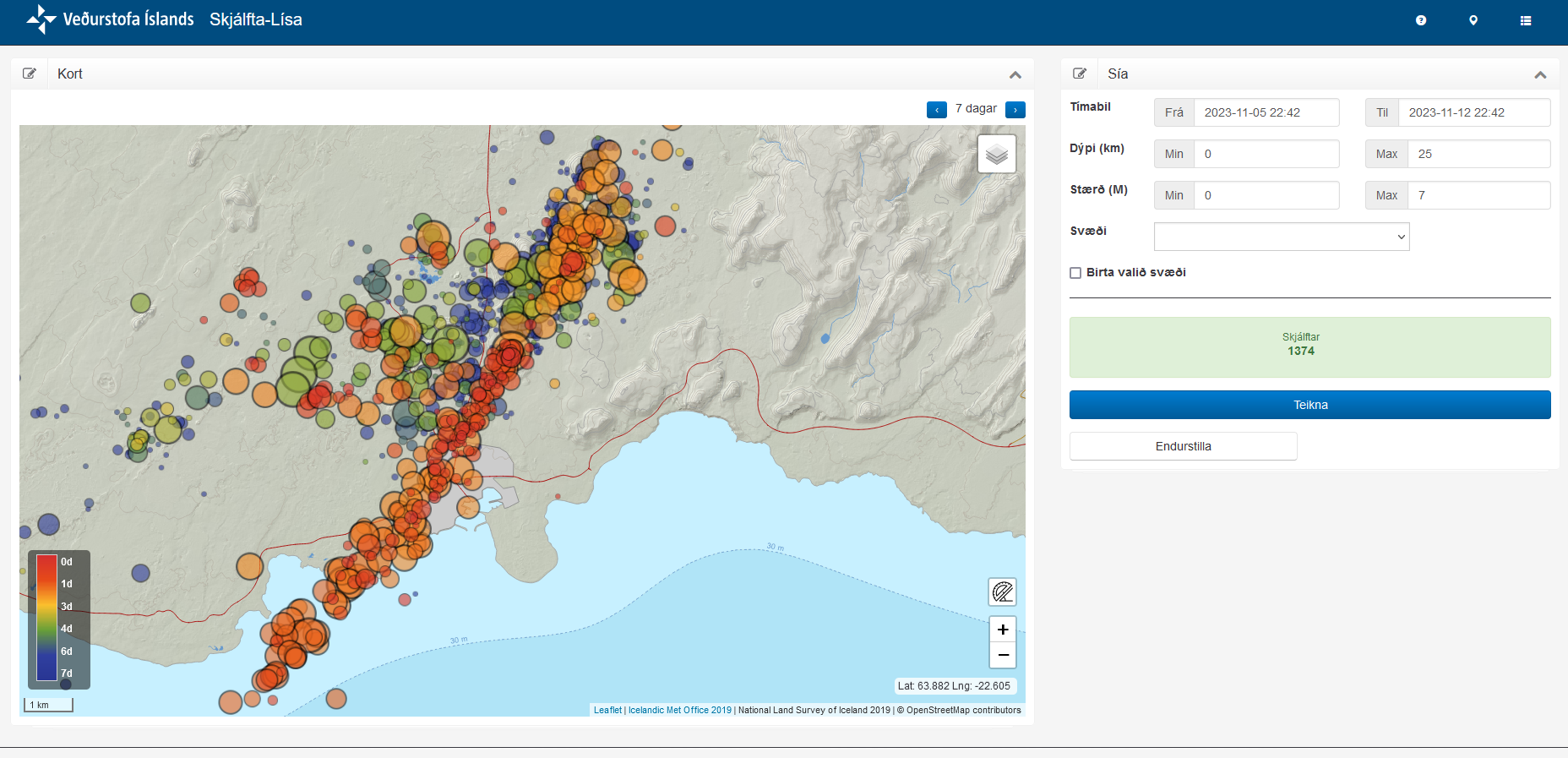
- This is a event that was not expected. Most of the inflation until Friday 10. November 2023 had happened in Svartsengi (Reykjanes volcano) and in Fagradalsfjall volcano. There had nothing been happening at Sundhnúksgígar to the north-east of Grindavík. Until Friday 10. November at around 08:00 when a earthquake swarm started in that location. Originally it was though those where just tension related earthquakes, but that view (according to reports) changed early in the morning at Icelandic Met Office. Everything did go crazy in earthquakes between 16:00 until 19:00 on Friday. This earthquake swarm was really dense and many earthquakes with magnitude Mw4,0 took place inside Grindavík town.
- There is damage in Grindavík, both roads and houses because of the displacement. Damages to pipes, electricity wires and other infrastructure.
- The dyke seems to be few dozen meters wide and up to 1 meters deep. It might be different wide and deep at its 15 km length. I have not found any useful information about this. Just information on its length that was last time I checked, 15 km long.
This is not a small volcano event. What I don’t know and this doesn’t seems to be known. What volcano is causing this. This might be Fagradalsfjall volcano or this might be Reykjanes volcano.
I’ll post more information about this when I know more or if anything more happens if I can.
“What volcano is causing this?” you ask. Possibly none; Iceland is a scab-like volcanic formation caused by seafloor spreading (therefore some areas may sink). The volcanoes are a symptom, not the primary cause. Can any geo-physicists confirm? Also, this sort of rift is essentially a tear; it might spread Southwest and/or East (and yes, it can affect existing volcanoes by increasing magma flow/pressure).
That is a possibility. But that is one large eruption that is going to happen to be not connected to any volcano.
Point taken. There may be shared magma paths. The magma will take the path of least resistance. A psychic I know talked about this eruption a couple of years ago; he said there was a (deep) rock plug (in an existing channel?) that would melt-through, but didn’t know if this was literal or purely symbolic. The eruption was pretty big; he saw some boulder-sized ejecta flying into the the ocean and airline flights disrupted.
Correction: The boulder-sized ejecta *might* have been (seemingly) flying up out of the water (!!) near the shore — consistent with an underwater explosion. I didn’t pay much attention at the time since it seemed rather outlandish.
The Holohraun eruption was preceded by a rift also so I will go out on a limb and predict that the actual eruption will occur at the Sundhnúksgígar crater row.
@Mudpot: Interesting — in the case of the Holohraun eruption it seems clear that magma was simultaneously following and propagating a tension rift until it reached the surface. The earthquake swarm started at Bárðarbunga and moved 45 km further northeast over a period of two weeks. So it was likely fueled by Bárðarbunga magma (Jon should approve), which had coincident caldera subsidence (because of pressure relief?). FYI, the tension faults run SW/NE in Iceland; many ridges and narrow lakes have a similar orientation.
My prediction is based on the idea that dikes and eruptions follow previous paths. The Holuhraun eruption was essentially a flank eruption of Bárðarbunga, but it followed a previous rift, or seemed to since the Holuhraun craters were there already and they erupted again. The current dike doesn’t seem to be on the flank of any known volcano but the Sundhnúksgígar crater row exists so I presume a prior rift existed there too.
That seems very reasonable and wise. I don’t see a mechanism for the magma to keep a rift open/molten for years, so I’m guessing the rift re-opens every so often due to increasing (tension) “strain” (tectonic plate movement), and it’s enough for fresh magma to start propagating. As the rock melts, the rift weakens (becoming wider/longer/deeper) so more magma flows and the feedback loop results in an earthquake swarm and eventually in an eruption.
In mechanical engineering lingo, “strain” is displacement, and “stress” is force. They’re related but not the same thing. If something is ripping apart strain can increase under constant stress.
Correction: Lava tubes could keep a rift partially open (thus accelerating re-melt in a future cycle) — even if partially collapsed.
Sorry about the Google adsense popup ad. Google Adsense turned this on without telling me and I can’t turn it off.