
Donations: Please remember to support my work with donations or by using Amazon store to shop. Thanks for the support.
This is going to be a short update for Bárðarbunga volcano.
There are changes taking place in harmonic tremor on the SIL stations closest to the eruption in Holuhraun. I don’t know what this means exactly, the best idea at the moment is that the eruption is either ending or getting less in power. It is hard to know for sure at this moment due to the bad weather in Iceland. This might also just be part of normal fluctuation of the eruption.
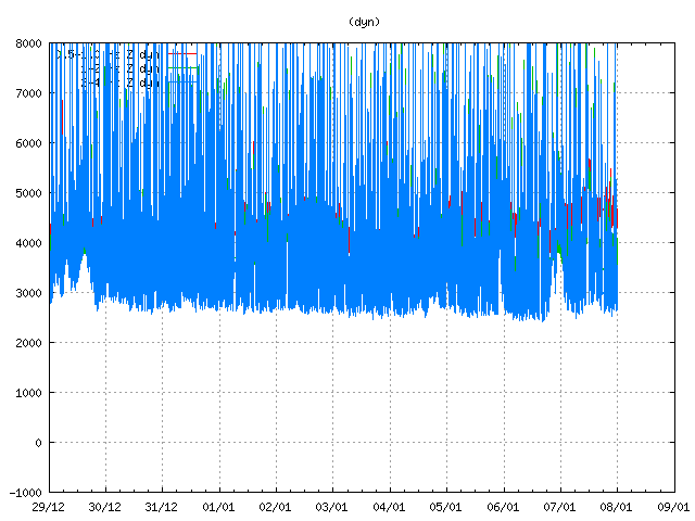
Harmonic tremor from the eruption in Holuhraun. Changes can be seen at the end of the trace. Copyright of this image belongs to Icelandic Met Office.
Earthquake activity in Bárðarbunga volcano is the same now as it has been for the past few days.
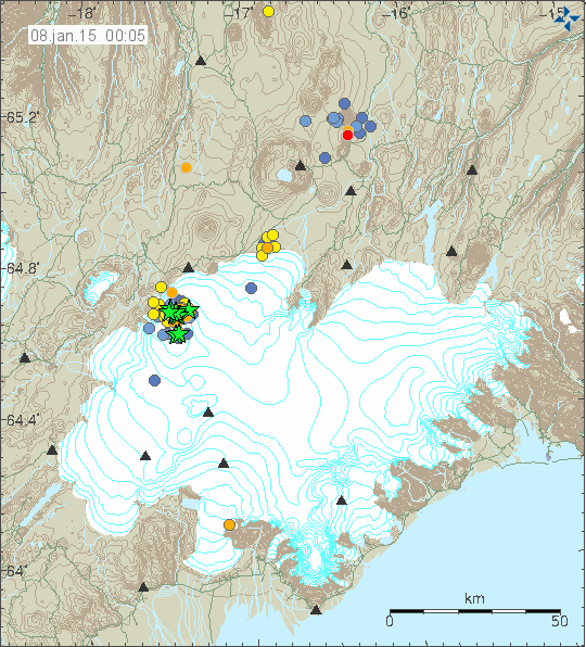
Earthquake activity in Bárðarbunga volcano for the last 48 hours. Copyright of this image belongs to Icelandic Met Office.
Currently there are only 11 earthquakes larger then magnitude 3,0 in Bárðarbunga volcano for the past 48 hours. That is among the lowest number of earthquakes since this activity started in August-2014. Total of 117 earthquakes are on this map, that is now considered as “few” earthquakes compared to what was happening from August-2014. Holuhraun lava field is now 1,15 km³ in size, it also covers ~83,11 km². It is about the same size as Þingvallavatn lake. It is only going to take few more days until it is larger then largest lake in Iceland.
Storm warning
Please note that there is going to be bad weather in Iceland until Friday to Sunday. I am not sure when there is going to be break in the bad weather. Observations of what is happening in Bárðarbunga volcano are going to be difficult at best during this stormy days.
So far . . . it looks like . . . in spite of the changes . . .
that the lava flows on and on and on.
Will be interesting to see what the landscape looks like come spring.
I hope, Jon, that you are in a warm dwelling! Winter storms in Iceland don’t sound very warm, at all.
Dyn tremor reading has been very erratic recently. Could this cause the change in the chart?
Yes Jon, this storm has been building under the jet stream, where a very large system is centred over Iceland and Greenland. We are in for another storm in Scotland although I’m not giving in to the hype as the confidence level is just 75% at the moment.
I’m not going to jump to conclusions over the tremor graphs as eq’s are still feeding through to the borehole strain gauges at burfell and Hekla, along with considerable fluctuations. The gps shifts have not ceased, as long as considerable movement is ongoing there will be a risk. Imho
Binni says:
January 8, 2015 at 00:58
New video https://www.youtube.com/watch?v=I6FJP5bZ6G4
I have copied Binni’s post to the newest article, because it’s one of the best BB videos I have seen so far
Yes, great video. Plenty of surface flow.
There is a car on the Mila webcam!
I hope they do something for better quality 🙂
Yesterday, the Dutch tv-program “De Kennis van Nu” (The knowledge of now, this moment) had a nice issue. http://www.npo.nl/de-kennis-van-nu/07-01-2015/VPWON_1236014
The had a sample analyzed by Dr. Manfred van Bergen, Dutch volcano expert from the University of Utecht, who concluded that the magna sample rose from a depth of 40Km in about a week before coming to the surface and that this depth was twice as deep as they had expected. Furthermore, the program several times noticed that a large explosive eruption was very likely to happen in the future.
“Furthermore, the program several times noticed that a large explosive eruption was very likely to happen in the future.”
Based on what?
What I understood from what Dr. Manfred van Bergen concluded, based on the depth that magna was coming from, is that the eruption of Holuhraun was not going to stop soon.
The program did not state its sources, but I understand that the expedition to get the sample was endourced by the Iceland government. They also visited the Icelandic Met Office. The segment about this visit is in English with Dutch subtitles, so you can listen to it for yourself.
I was only making this notice because some serious attentions is being payed to the dangers of a possible eruption in the Dutch media. Another issue about this can be found here: http://www.npowetenschap.nl/nieuws/artikelen/2015/Januari/bardarbunga.html
They just said possibly, if the caldera starts erupting and because of all the ice on top, just like IMO. This program is absolutely not sensationalist. They really try and give you a scientifically sound picture of what’s going on. of course they could have asked a sample of magma straight from imo but that wouldn’t make a nice program.
Yes, but is that the future as in later on in 2015, or the future as in 2174?
The media, from any country, only publish when they can sensationalise events. In Britain they have been ignoring Icelandic events. Thankfully the uni’s in the UK have been assisting the IMO.
What they are all missing is the impact on the climate of the current eruption. It is easy to overlook this as it doesn’t look dramatic to the untrained eye, but the emissions of co2 and so2 have been very significant.
I have no doubt at all we are seeing influence from this now, with the higher than normal temperatures. I believe it will lead to dramatic swings and very large systems affecting the jet stream.
@ Scots john…saying ‘higher then normal’ temperatures is a bit dramatic…..0.2degrees c worldwide…..and the eruption only happened 3/4 of the way into the year
@acidohm
Here in the UK 2014 was the warmest year for a long time.
So far January is following suit. The depression in the jetstream centred over Iceland/Greenland will bring a change to the surface weather over the next week. This has been a noticeable warmth in Scotland that is unusual, winter will come.
The slight average global rise you speak of is far more important that you realise as it is a global average. It is not a temperate zone figure, nor specific to particular areas. An example of this is the extreme cold in some US states.
When you see an average rise combined with extremes in different areas, then you are going to get violent weather systems.
Now, I said I believe the emissions from holuhraun are having an effect, over recent months you will be aware the area has had its own microclimate visible from time to time, but that is not what I am referring to. I am referring to the solubility of these gases in the atmospheric water vapour in the northern hemisphere.
These have several effects including magnification of solar energy, creating denser cloud cover which then has the opposite effect. There are so many variables. I am not trying to convince you, just saying you will see it for yourself.
I agree Scots John, it would be very interesting to see an effect in the temperature record from this event such as we saw from pinatabo for example.
However as temperatures globally have been at a sort of plateau or ‘pause’ for 18 years, it only stands to reason that warmer years will edge over some others, I think these things can only be seen as significant after many years, we simply don’t know where things are going short to medium term.
They just say that IF the caldera would collapse, there would be a explosive eruption. Basically what IMO states in their updates as option 3 since the start of the eruption. They don’t link this with the observations made by Manfred van Bergen.
M v B has a state of the art high resolution microscope especially designed for magma research. He concluded from lava samples from holuhraun that it must have come from 40 km in depth to the surface within a week. He concluded that from immature crystal size and shape.
There could though be a connection.
If the magma is really now from 40 km depth, it would mean that the composition of the magma would have changed during the eruption.
It would mean that it is now a more primitive magma erupting at Holuhraun, which comes directly from the mantle (the mantle is thought to be at a depth of around 30-40 km beneath this part of Iceland). This could mean that there is no magma / or not a lot magma anymore from the main volcano feeding the lava field at Holuhraun. And that it would have a really different and perhaps even more or less inexcaustible source. And then this eruption (at Holuhraun) could only stop by congestion/blockage of the feeder dyke.
And on the other hand, a still unruly Bárðarbunga (the earthquakes) – not connected (any more?) – to the lava field, could really mean an upheating volcano, with a heightened possibility of an explosive eruption.
Magnitude 4.6
Region ICELAND
Date time 2015-01-08 15:43:09.9 UTC
Location 64.61 N ; 17.49 W
Depth 10 km
http://m.emsc.eu/earthquake/earthquake.php?evid=421260
USGS:
5.1 123km S of Akureyri, Iceland 2015-01-08 19:47:12 UTC+01:00 4.9 km
Thursday
08.01.2015 18:53:57 64.720 -17.320 2.6 km 3.6 50.5 8.6 km SW of Kistufell
Thursday
08.01.2015 18:47:10 64.652 -17.493 3.0 km 4.9 99.0 2.1 km NE of Bárðarbunga
Thursday
08.01.2015 18:47:10 64.652 -17.493 3.0 km 5.1 99.0 2.1 km NE of Bárðarbunga
yea! 5. big. something big is going on and I think this rifting is just the start to what is really going to happen.
What a Quake, what a Quake, what a very Big Quake.
40km, that’s some interesting data and it makes all sense.
But I am still skeptical by such data coming from a dutch tv show.
Nevertheless I believe on it. If that is so, this eruption could last for years. I often said that, that this was, is and will be a shield volcano type of eruption. Time will show it.
By the way, I was sleeping a nap but around 18:50 heard a thunder like noise coming from outdoors, and yup, it was just another felt quake from Bardarbunga. From my own experience, it needs to be at least a M5 event to be felt and heard here at south Iceland.
well! could I just add this one thing.
The magma looks too fluid. Meaning it seems to be flowing like water (from video’s I have seen).
So it could be coming from greater then 40Km, Maybe From The Core…………………………………………………….
🙂
Interesting if correct, that 40km figure. Sounds to this total amateur as if the eruption may continue a while yet, and next summer’s visitors may have a new attraction on the tourist trail.
By the way, I can’t see your Amazon links any more on my Firefox 12 browser.
Then you have adblock active in your browser.
Maybe this is a deep sourced magma surge under the caldera, which is a a tightly sealed system, like a jar with a strong lid but there is a leak in the side of the jar.The shallow depths of the caldera undergoing secondary magma induced heating at the same time that the fissure eruption is occurring. These two events related but not connected, in that they both have the same feeder source, but the fissure has more of a direct relationship with the primitive magma source and the caldera an indirect relationship.A dual personality event, the more evolved caldera being thermally reawakened by the tremendous influx of rift sourced basalt?
JB (and all others):
This is the way I view it. The magma was under pressure and was pushing, and probing for the path of least resistance, heading from the Bardarbunga caldera towards Grimsvotn. But something intevened, the major rifting event, and so the magma took a sudden turn to the NE. Everyone watched as it kept climbing and seeking a path of escape until it surfaced in the Holuhraun area.
I expect future eruptions to continue to follow this path of least resistance, and more lava to surface in future eruptions in the Holuhraun location. Perhaps a shield volcano will emerge, as some have suggested.
Just an opinion, but it is fun to watch all the events play out. ( but my heart goes out to all the Icelanders who had to put up with the SO2 smog, that is no fun at all)
Randall
Ahem, I think it is obvious that, even looking at a map of Iceland and the area surrounding it showing ocean depths, something over long geologic periods of time seems to “move” the island north. Well, looking at the current geologic volcanic events, the eruption at Bardardunga from lava moving, collecting, and creating a new shield volcano flowing lava out and north, is putting more Iceland north, and moving the eruption away from its formerly active southern caldera. Along with slow disintegration of land to the south sinking slowly into the ocean, and added land to the north, it seems to merely be a continuation of normal geologic evolution, and this is just one phase of an extremely long and old process shaping the island and continually “moving” it north.
To my knowledge Iceland, and the tectonic plate system, is moving to north-west by approximately 1,8cm /year. The hot-spot, located under the Vatnajökull area is stationary and moves relatively to the position of Iceland to the -south-east.
Iceland is not being moved north by tectonic/volcanic movements. And its southern areas are not sinking or shrinking.
There was a lot of lava production in the south during the Holocene – we have to think in geologic time spans here – , incl. one of the most important lava flows known to geology (the Þjórsárhraun, 8.000 years ago, about 20 (!) km3, curtsey to our Bárðarbunga). The latest really big effusive (lava) eruptions were all to the south, Veiðivötn, Vatnaöldur (both again produced by the Bárðarbunga volcanic system) and Laki, in 1783-84 (Grímsvötn volcanic system).
The land is also not only eroded by the sea, but this is more than compensated by the jökulhlaup, which transport lots and lots of sediment to the sea shore, so that in some regions, the land surface instead has grown (again in the south of the country, ie. on the Skeiðarársandur (not far from Höfn) and on the Mýrdalssandur near Vík, another plain produced and widened by jökulhlaup from the Katla volcano resp. the Mýrdalsjökull glacier.
And last but not least, the land to the south is not sinking, quite the contrary. Due to isostatic rebound, because the weight of the retreating glaciers is lifted from the land, there has been constant and considerable uplift. And esp. in the south at Höfn, there have been measured around 4 m of uplift within some of the last years.
Yes, Ingi is right. Where did you get this idea Wendy?
Iceland is not sinking, in contrary, it is pushed upwards from the seabed by rising magma.
ALso Iceland is rising by isostatic relief, because of the former ice age.
And Iceland is also growing and rising by erupting lava and sometimes by glacial floods which extend the coast lines further out into the sea.
Sinking? Only very locally in calderas, when lava comes out somewhere else, like between Bardarbunga and Holuhraun. Or when rifting occurs, and land sinks as a graben because lava doesn’t fit the void quickly enough (like Thingvellir or the new rift valley north of Dyngjujokull)
But overall Iceland is growing.
Perhaps you mean both American and Eurasian plates are moving respectively NW and NE, so there is yes a bit of northwards direction, depending on your reference point. And because the American plate moves faster, the “stationary” mantle plume, seems to move southeastwards. But the shaping form of Iceland is a complex of many factors. There are to start with, two active riftiung regions, at the moments, lava can flow over millenia in many directions, and glacial floods too. Like Ingi said, southwards is also a main direction. ANd then isostatis relief makes the southern lowlands rise faster than the sealevel variations, so land seems to grow towards the ocean.
Iceland is sinking, but only on the edges and not that fast. Over the course of next 2 million years the Westfjord and eastern part of Iceland are going to sink into the ocean.
This happens due to two things. Drift of the crust and cooling that is contracting that same crust. This is most visible when you view deep sea map of Iceland like this one.
http://en.wikipedia.org/wiki/Outline_of_Iceland#mediaviewer/File:Icelandic_ocean.svg
In the whole, there is an uplift in Iceland, due to the glacier mass balance, ie. the receeding glaciers. The prediction (by geologist Freysteinn Sigmundsson from University of Iceland) is of up to 4 m until 2100, if the developments continue as during the last years: http://onlinelibrary.wiley.com/doi/10.1029/2006JB004421/full
The weight of the glaciers is lifted, and as the lithosphere is in a way elastic, the land surface is adjusting to this. There was also considerable uplift at the end of the last glaciation around 10.000 years ago.
The induced higher rate of volcanism, would be a consequence of this uplift, not the other way round. This is called production of decompression melt – higher magma production due to reduced compression. http://rsta.royalsocietypublishing.org/content/368/1919/2535.full There is though a lot of work still to be done, to know more about the possible risks of this development.
http://www.npowetenschap.nl/nieuws/artikelen/2015/Januari/bardarbunga.html
An article about the lava sample researched by manfred bergen in dutch. Only without the conclusion about depth, just sulphur content. It does pretty good in gigle translate.
To be honest I simply check the IMO site each day to see the new stuff, together with this site for more background info / thoughts and so on. but a Dutch expert on volcanos ?? , we only have one volcano in the Netherlands the ” Zuidwal vulkaan”
anyway this one is already pretty old, http://en.wikipedia.org/wiki/Zuidwal_volcano
so if it comes to experts in the Dutch please ask us about water, dykes and protection against the see, and so on
It does not matter from which country you are coming from. It just matters which subject you choose for studying and to become a professional in. I’m sorry, but you expose quite primitive thinking about where good volcanologists should come from…???!!!
sorry was more meant as a joke, you are right
I would say, let’s ask the Hollanders about new volcanos AND when we need a better dijk. Obviously they have some expertise on both. :p
Dijk, dike, what’s the difference 😉
I would like to post comment regarding global temperatures, this past year in 2014, in terms of looking at the percentage of all time records that are all time Hot records for particular weather station locations based on all available historical data from those stations:
Based on around the globe weather station reports and historical records, in terms of all time Hot and Cold records set: 74 New all time high temperature records were set this past year (NOAA global records summary) and 19 New all time cold temperature records were set this past year. So we have set 79.6% Hot records vs. Cold records. Based on the binomial distribution for percentages, assuming a 50% underlying probability (the null hypothesis of no global warming) the expected range for 50% based on N=93 is 34.4% to 65.6%. I.e., expect by chance over 99% of the time for actual percentage to be between 34.4% to 65.6%. But for 2014 the actual percentage of Hot records set out of total records set is 79.6%, which is considerably above the P-chart ‘upper control limit’ of 65.6%. We see the data gives us an objective conclusion that it is NOT 50%. There must be a special cause.
so when you say “all time records” are you speaking to the satellite era? if by long term records “ground stations”, then station location change, i.e. 100 years ago the station was in a field and over time the surrounding area was built up has to be figured into these records.
http://www.ncdc.noaa.gov/cdo-web/
Climate Data Online (CDO) provides free access to NCDC’s archive of global historical weather and climate data in addition to station history information. These data include quality controlled daily, monthly, seasonal, and yearly measurements of temperature, precipitation, wind, and degree days as well as radar data and 30-year Climate Normals.
and yes you have a point: http://www.c3headlines.com/global-warming-urban-heat-island-bias/
Yep….it’s called natural variability. …
Pretty cool compared to 1000 years ago, Romans had grapevines in North England, vikings had farms in Greenland.
Acidohm, temperature in Iceland and Greenland was about the same 1000 years ago as it is now. Not warmer, neither colder. Just about the same, at least judged by glacier advance. I know the data.
In Skaftafell national park in Iceland, you can see the data for yourself. 1000 years ago, climate was just about the same.
Regarding 1000 years ago “farms”, the vikings were growing grains (barley) like we do it nowadays, but during the little ice age, and for many centuries, grain growing was impossible in Iceland, up until this last century. Wheat (which is less cold-tolerant than barley) was never grown during the viking time, but it is nowadays. The situation in Greenland was identical to Iceland.
Please dont just say things you read somewhere, things which are not fully incorrect.
In the Alps (at least in Austria) however the situation is different. The climate was still colder 1000 years ago than nowadays (or at least glaciers were more advanced than nowadays), but some 4000 years ago the climate was, yes, significantly warmer, with trees growing where now is melting glacier.
Let’s stick to the facts acidohm.
@ irpsit, hats off, can’t argue with your knowledge and we’ll put ☺
The climate in Iceland was a bit warmer during time of settlement (from the 9th to around the mid 13th century, when Little Ice Age set in).
See eg. http://en.ni.is/botany/vegetation/changes-in-vegetation/
resp. http://www.nabohome.org/meetings/glthec/materials/keller/ArcticAnthro401-02-2.pdf , esp. p. 14
See further to climate changes in Iceland: http://lup.lub.lu.se/luur/download?func=downloadFile&recordOId=626150&fileOId=626499 and http://onlinelibrary.wiley.com/doi/10.1002/j.1477-8696.2000.tb04028.x/pdf , esp. p.10 There was esp. a reduced occurrence of sea ice at the time of settlement in Iceland and Greenland which should in itself indicate a warmer climate. Also in the sagas, which are used in Iceland partially as historical sources they say that climate was rather favorable for voyage and settlement at the time. It has though to be said, that these sources are also discussed re. their reliability.
BTW: The Roman Empire perished around the year 500 AD whereas the vikings started their Greenland settlement around the year 1000 AD.
Further to what Inge says, if my memory is correct, traces of an old farm have been found adjacent to Frostastaðavatn, which is quite a bit further into the Highlands than anywhere that is currently settled.
It’s reckoned that it was abandoned ca. 1400s, I think.
Andrew, that made me rather convinced. I couldn’t think of a farmer living nowadays at Frostadavatn. The climate, and especially the winter must have been warmer, milder, with much more rain alternating with snow there, because nowadays that spot gets meters of accumulated snow. Perhaps climate was yes milder. At least I think this initially.
But data from the glaciers in Vatnajokull do not show a significant difference from nowadays. Now, we must explain why such farm would be there. First, the viking that settled there could have been extremely crazy and brave (I mean outlaws survived in the highlands even during the little ice age, so that is one possibility). Second is the farmer settled during the onset of the middle ice age, climate was colder but drier, so he could have relied in less accumulated snow.
Anyways we get another hint of a slightly warmer climate then. In the Alps 1000 years ago, it was apparently colder than now, but some 4000 years it was significantly warmer.
Jon, For whatever it’s worth . . . and that not much . . . for my amusement, I’ve continued to follow the DETTIFOSS on that shipping map . . . it really gets around the North Sea! Thanks for that website.
Has anybody seen the new directions some bigger than magn. 3 earthquakes took recently http://en.vedur.is/earthquakes-and-volcanism/earthquakes/vatnajokull/ ? New intrusions in SE and S direction? Could the very shallow depth – mean that they are lateral ones, but then they would come from a shallow magma source within the volcano …
08.01.2015 19:18:46 64.599 -17.539 1.5 km 3.8 99.0 4.6 km S of Bárðarbunga
Thursday
08.01.2015 04:51:33 64.607 -17.397 2.3 km 4.2 99.0 7.2 km ESE of Bárðarbunga
Also interesting is the comparably important distance from the caldera center in the case of the 2nd quake.
Is it likely that any possible shallow magma body has a lower temperature and gas content in the south of the caldera as compared to the north , as well as less voluminous? Is it the case that heat transfer in highly vesiculated magma is considerably less than magma in a more solid state?
I think this paper could give an answer re. the conductivity of highly vesiculated magma. http://epub.ub.uni-muenchen.de/6040/2/Dingwell_Donald_6040.pdf As far as I understand this, if magma has developed a foam layer the rest of the magma chamber / pocket is sort of isolated re. heat transfer. And even the convection within the chamber might be suppressed.
And could not very different magma pockets be “working” at different locations under the ice at Bárðarbunga?
It is more than likely that it is not a uniform reservoir of magma , so interaction with the surrounding geology are not going to be different depending on the location?
It’s the unrest of the volcanos arrownd Bardarbunga that we talk some time ago…
Inge this was the direction of the first subglacial unconfirmed eruption, in the south edge of Bardarbunga caldera, around the last two weeks of August. It seems like normal behavior, perhaps a new lava dike towards that direction.
As long as it does not goes southwest, I am fine with it.
I know that one of the first subglacial eruptions took place in this direction, question is: will there be another one at this location. – Definition of “normal behaviour” in volcanoes = ? – Building of new dikes always is of interest in such a situation, one / some of them could become a feeder /feeders and initiate a subglacial eruption which could mean different consequences – depending on ice thickness above the location at which the dike reaches the surface and the force of the eruption (not all of them stay under cover, as we know). BTW: Some dikes have been known to even enter ice covers (anyway for short distances).
But what I find interesting is how Grimsvotn, so close to all these events, has managed to keep quiet.
I reckon next events, if they happen, will be east or northeast of Askja, north of Tungnafellsjokull or at Kverfjoll. This based in earthquake tensions, and Kverfjoll is just a personal guess.
Hello Inge,
I noticed the 2 green stars clearly south of the caldera too and wandered if the fresh magma (that a few of the commenters and Jón too here allready mentioned: quite a few deep quakes lately, which suggests the entering of fresh magma at depth) now has the tendency to go south (maybe a path of less resistance?)
It’s remains very interested what happens next!
Kind regards,
Henk Weijerstrass
Holland
This is just what I meant. 🙂
Just need to know if adding one molecule of co2 in 10000 molecules of atmosphere is that special cause bearing in mind a molecule will not just absorb IR but also emit IR. Sorry. Gone off topic. BB eqs continue albeit with reduced frequency and hardly no plug sliding movement. What is the focal mechanism of thee eqs. What is the process ?
In my opinion, the mechanism is thermal to kinetic,large magmatic heat source transferring energy into cooler rock as earthquakes and this effect is intensfied by the thick ice pack(heat engine),but that’s probably not even scientific lol
The evidence in this case seems to support more and more your first theory here …
Could it not also be that the central volcano was more involved in the beginning and the activity is now changing and developing into two more or less independent cases?
But could you perhaps explain what you mean with the ice pack as a heat engine? Can ice function as an insulator?
The ice pack increases the temperature difference between the geothermal source and the rock, so if the incoming heat is large enough the system gets out of balance and the excess energy has to be expended as earthquakes, as I said this idea may not be scientific? http://logherscience10.blogspot.ca/2014/09/energy-transfers-all-around-us.html
New article about Bárðarbunga volcano is up. 🙂
I am really enjoying reading your well written articles. I think you spend numerous effort and time updating your blog. I have bookmarked it.thanks for share it with us.