
This is a short update about the eruption in Bárðarbunga volcano.
Not much has changed since the update on Wednesday 7-Januar-2015. If there was an drop in the eruption, it was temporary and the eruption in Holuhraun has not resumed at earlier levels. At least no change has been observed from Míla web cameras today.
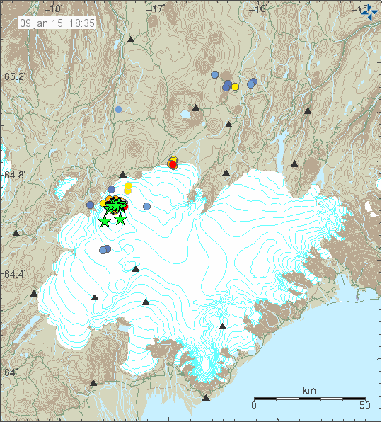
Earthquake activity in Bárðarbunga volcano for the past 48 hours. Copyright of this image belongs to Icelandic Met Office.
Largest earthquake in past 24 hours had the magnitude of 5,1. That earthquake took place in North-east part of the caldera in Bárðarbunga volcano. Smaller earthquakes have been taking place in that same area and have been doing so for the past four months. Small swarm of earthquakes have been taking place in the dyke close to the edge of the glacier. I don’t know for sure what that means at the moment, but I do not think it is a good sign. Since there is a high risk of eruption along the dyke, even if there is eruption taking place at just one location at the moment. The dyke is ~46 km long and most of it is under Vatnajökull glacier.
This time of the year glaciers in Iceland area adding weight to them due to snowfall. The chances are this is having effects on Bárðarbunga volcano. Since snowfall on Vatnajökull glacier is around 10 to 20 meters during the winter (this depends on the year). Pressure from the glacier is currently increasing on Bárðarbunga volcano, I don’t know for sure what effects that is having, but it is my best guess that it is slowing down what is happening in Bárðarbunga volcano. Glaciers start to get lighter in June to September each year when the summer melt starts again.
Article updated at 22:25 UTC.
I’m not a geologist and am trying not to get in the way, but I am a bit intrigued by the idea of a substantial and prolonged flow of hot lava through a cooler and partially-solid two-D layer. I guess the current tubes are on the order of 3-10 km long? Do they develop kink instabilities? How quickly do they expand and contract in response to changed flow? The material flowing through them is a mixture of gas and liquid rock. Is ten kilometers enough for the different materials to sort themselves out, perhaps resulting in surges at the terminus?
I don’t need a long reply. A link to a paper would be appreciated.
What I found on lava tubes: http://www.higp.hawaii.edu/~scott/Workshop_reading/Greeley_1987.pdf This is though a bit old.
Thank you!! Just what I needed.
Dear Jón,
I don’t think that 10 or 20 meters of additional snow on the Vatnajökull is going to have any influence on what is happening in Bardy; the pressure inside Bardy is enormous! In other words, I don’t think it’s going to slow down this beast of a volcano!
It took Gjálp in 1996 only 24 hours to melt it’s way through 600 meters of ice, so I don’t think 20 meters of snow will have any impact!
Kind regards,
Henk Weijerstras
Holland
@JB months ago I did a very rough calc that a 5.2 eq energy was equivalent to a slip of the plug of about 40cm which seemed to correlate well with co zistent 5.2 eqs and the subsidence at the time. With a 5.1 and no subsidence my simple theory is destroyed. A 5.1 is bigger than a Nagasaki fatman atom bomb. A localised fracturing due to heat difference rather than tectonic stress must be producing a large fracture perhaps from lava to the surface.
My theory has always been that this is a thermally induced event, due a large influx of basalt due to rifting heating a long existing shallow and evolved magma body? Magma chamber would give the impression of a uniform reservoir of fluid magma and at shallow depth this is possibly not the case, I think it is more a deposit of various thickness and consistency.Now if this is the case and it probably is not, is the primitive basalt physically connected to this shallow magma and direct mixing taking place?
JB, it is really hard to understand your writing. If you could put in some effort to write more clearly.
Andy, maybe the solution is that the 5+ quakes have horizontal movement, and we always have seen that the subsidence occurs rather smoothly without big jumps caused by quakes. There might be some shearing/rotation going on at the caldera rim caused by combined forces from rifting stress and transform fault stress.
@stefan lol, did you read you’re own comment?
@JB, I just think that your answer to Andy’s comment is nothing more than some weird magma chamber theory. You seem to have fun writing about these things, but from a geological point of view, it makes no sense (relation to earthquakes). If you have any question to what I write, your welcome to ask about details. Not sure if you know what is a transform fault.
Is not a transform fault, where 2 sections of the earth’s crust slide past each other? Now if the quakes are due to this then the fault causing them should be apparent? I was under the impression these are volcanic tectonic earthquakes caused by magmatic influence on the Caldera rim fault? But as you are the geologist I guess what you say must be correct and the onus is on you to be correct, I am under no such compunction and have never claimed to be an expert, but your explanation is vague and does not make sense.
JB, you said that “I was under the impression these are volcanic tectonic earthquakes caused by magmatic influence on the Caldera rim fault?”
I’m not a geologist and am having trouble making sense of this, could you explain it, please? Thanks.
@stefan: I think you’re right with the rotational explanation. The longer term GPS measurements directly around BB imply rotation. On this blog I did remark on when playing the daily eq plots in sequence that there appeared to be a rotation movie around BB. I thought at the time maggma corriolis effects. May just be an optical illusion and needs to be analysed. I think a tectonic twisting is a better explanation. Thanks.
@JB, thank you for writing clearly now. Much better! I must not be right, but it might be a plausible explanation for the earthquakes. Something has to move, and we don’t see sudden drops when we have bigger earthquakes. If you look at some tectonic maps of Iceland, you can observe that exactly at the location of Bardarbunga a transform fault and a rift fault are meeting. That implies shearing/tectonic movements to various directions. Making rotation possible. Best would be to have it confirmed by GPS measurements, which Andy is writing about. Anything published yet? And yes, transform fault is the case when the crust is sliding horizontally past each other, a rift fault when the crust is departing from each other. JB, I was mentioning tectonic stress caused by two fault systems causing rotation, I did not say that the earthquakes are caused by transform fault, ok?
@Andy, thanks for the great comment! Would be good to see some good seismic analysis of all earthquakes soon!
Re my question at 09.41 to JB, I should have said that I can understand the words but I don’t understand the *sentence* – the mechanisms you are suggesting are at work.
For example, I’m not sure I grasp what you have in mind when you write of “volcanic tectonic earthquakes”. Could you explain in relation to Bardarbunga what you mean by this, please.
@Stefan Mueller, 12.06
You ask if anything has been published yet. This article is very interesting and informative on the tectonic processes thought to be at work:
http://link.springer.com/article/10.1007%2Fs00445-014-0869-8
@Andrew http://pnsn.org/outreach/earthquakesources/volcanic
@stefan , what I meant to say , is that writing an idea in a short sentence or paragraph, it can difficult to get the idea across clearly.What you describe may be correct in terms of the mechanism causing the quakes , I was trying to figure out what is causing this mechanism in the first place and to me the dynamics of a shallow magma body explains this, but that is just an idea and it could be without foundation.
Thanks.
In theory, if a fissure opened up under the Vatnajökull ice sheet, would we even know this before it broke through the ice?
Is it possible that lava flow underneath the ice could happen totally unnoticed?
Please use a valid email address when you post a comment here. You continue to end up in moderation if you are always changing your email address.
There could be earthquake swarms at the location. But sometimes, it really seems not to be recognizable without any doubt, as was eg. the case with some of the first subglacial eruptions of this series, if you remember.
A paper on subglacial eruptions under an ice cover: http://www.planetary.brown.edu/pdfs/3282.pdf
This paper is specializing on heat transfer during basaltic subglacial eruptions: http://sp.lyellcollection.org/content/202/1/5.refs
Apropos: I don’t know if this has been linked in here yet – an experiment during which lava was poured on ice: https://www.youtube.com/watch?v=Fcz3vBdI7Nc
It really shows that the ice is not melting as fast as one would imagine!
Ingi, this experiment is pretty educative.
It shows how a subglacial eruption could be easily supressed or weakened by a large ice cap on top of it.
It also shows that any eruption in Grimsvotn or Katla or Eyjafjallajojull requires a large intensity to break through the ice cap, otherwise it will be killed quickly to cooled rock. Probably this happened in Katla and Hamarinn in 2011.
It also shows that a glacial flood only follows after a certain period of time, because lava does not melt as much as ice as one might think.
Steam might be present in subglacial eruptions and be quickly cooled to water and even ice, if the amount of lava is not much. If magma has enough amount and pressure then the steam will erupt violently at the surface of an ice cap.
Thank you, IngeB! Those papers seem very interesting, but are going to take me a good while to digest. Hopefully I will have the time to read and understand them.
About that video clip, I’m fairly sure we would see a completely different reaction if ice was dropped into lava instead of the opposite!
Jón:
Sorry, I didn’t realize that this was a problem. Out of habit, I don’t publish my e-mail address in public areas because I want to avoid getting spam. This is probably not an issue here, so now I’m using a valid address!
Magnitude 4.7
Region ICELAND
Date time 2015-01-10 18:23:41.0 UTC
Location 64.54 N ; 17.43 W
Depth 8 km
http://m.emsc.eu/earthquake/earthquake.php?evid=421922
hi everyone . I could wrong on this but it looks like a new fissure may started on the extreme left on mila 1 cam . I still going for break in the lava tube but not an expert . please have a look and help .thank you
There is some activity to be seen there, but not clear enough to be seen. Could be an outbreak of a lava tube and the lava meeting the river – hince the steam clouds (rootless cones building?).
I think “new fisssure” is not the right word for what we can see. I would call it “fissure” if it was a new break from the underground.
I can see a glow of something behind the hill where mila 1 stands, so as Inge said, something like the end of a lavatube or -flow.
Fresh lava (from a lava tube) illuminates the steam which is always there.
I am going to get the first dose of SO2 pollution tomorrow according to the weather forecast. I don’t know if this weather forecast is going to come true or not.
The forecast of the SO2 pollution tomorrow. http://en.vedur.is/weather/forecasts/text/gas/
Let’s hope it won’t be bad where you live – and neither anywhere else in Iceland. Acc. to what I saw these last weeks, it was not bad anywhere perhaps with the exception of some part of the southeast. http://ust.is/einstaklingar/loftgaedi/maelingar/
Strange, since a week I can’t watch mila cam 2 anymore, it just shows a blank page with ‘404 Not Found’ ?? Mila cam 1 is ok. Can anybody help?
Dear Stefan,
I have the same problem and announcement: 404 not found.
Henk Weijerstrass
Holland
Cam 2 is down since friday
Saturday
10.01.2015 18:23:39 64.672 -17.466 8.3 km 4.7 99.0 4.6 km NE of Bárðarbunga
For those who have never seen what happends when water comes into contact with lava, someone throws some in a watercan into Erta Ale lava lake.
https://www.youtube.com/watch?v=f9f6oaiQ5gA
I also noted the steam on Bard cam one, just thought it was lava in contact with water!
There is very clearly a new eruption on the left of Mila 1. also a smaller fissure eruption which has been on and off all morning.
It will be interesting to see what it looks like in the daylight.
Marion
Yes, there does seem to be something new going on there.
It’s hard to judge the scale, but it looks to me as if the normal steam is dark and in the foreground, and then behind it there’s lava illuminated clouds/gas that are sometimes obscured by the foreground steam. Maybe it’s just that the NE tip of the lava flow has become a bit more evident…
No new seismic activity in the area is showing, and so far as I can read tremor guages (which is barely at all), they don’t look significantly different from previous days, and if anything, a bit quieter.
Since the ceiling collapsed from the tunnel! Nothing more!
Ok – thanks, I wondered if that was what it might be.
If you mean the left border of MILA Cam1 … this is only fresh lava (from a lava tube) illuminates the steam which is always there.
I have always wondered if the Icelandic quakes are having an affect on the Reykjanes Ridge or is this just coincidence.
Magnitude M 4.6
Region REYKJANES RIDGE
Date time 2015-01-11 08:48:01.3 UTC
Location 52.90 N ; 34.71 W
Depth 10 km
Emsc
It’s all the Mid-Atlantic Ridge – movements in this, along the different Icelandic seismic zones, are causing most of the earthquakes. (Some seem to be being caused by magma movements and others, around Hengill, by water pumping associated with the geothermal power-station there.)
New satellite image from the lava field -> http://earthobservatory.nasa.gov/NaturalHazards/view.php?id=85031
Sunday
11.01.2015 05:27:34 64.651 -17.378 17.6 km 4.5 99.0 7.2 km E of Bárðarbunga
Hello Jon,
fyi: there are some problems with your Webicoders. The grafics are often shown only half.
I did think it was just my computer, since I am not on that good internet connection. I will try and fix this. I don’t know for sure why this is happening.
What just happened at the Mokollar station?
http://hraun.vedur.is/ja/vatnajokulsvoktun/mko1_trem.gif
hi everyone, does anybody know what is happening with jokulsa?
http://www.ijsland-enzo.nl/ijsland/actueel_waterstanden.asp
If IMO measurements are correct, water height in Jökulsá á Fjöllum at Grímsstadir went up from from 166 to 280 cm since 6:00 this morning and the discharge from 136 to around 520 m3/sec, falling again at the moment. But strangely the measurement device at Upptyppingar which is nearer to Vatnajökull doesn’t show anything. http://vmkerfi.vedur.is/vatn/vdv.php?p=0&station_id=222&page_id=342&direct=1
I think the movements at seismo station Mókollar could be this water wave.
Checked on the tremor graphs in comparison, don’t think water and tremor are connected now.
There is a movement within the high frequencies which began yesterday and is eg. very pronounced at station KRO (this is Krafla): http://hraun.vedur.is/ja/oroi/kvo.gif Station REN shows it also very well (again volcanic system of Krafla): http://hraun.vedur.is/ja/oroi/ren.gif
Station SKI shows it also, but not so clearly: http://hraun.vedur.is/ja/oroi/ski.gif This station is neither too far from Krafla, a bit to the northeast within the volcanic system of Theystareykir.
This is not within the Vatnajökull region, but about 150 km to the north of Bárdarbunga.
This are frost quakes. The temperature has been -10 to -20C in some areas.
If anyone from the UK reads this programme is showing on either BBC1 or BBC2 after the darts .
..Kate Humble joins a team of geologists at the Vanuatu archipelago to investigate some of the most active volcanoes in the world – and to predict if another major eruption might be imminent..
I don’t know if there is a connection but there has been a big drop in the subsidence chart over the last few hours It does not look like it is going to level out on the 3 hr MA .
Magnitude mb 4.5
Region ICELAND
Date time 2015-01-12 00:22:44.3 UTC
Location 64.42 N ; 17.95 W
Depth 8 km
Distances 194 km E of Reykjavík, Iceland / pop: 113,906 / local time: 00:22:44.3 2015-01-12
141 km S of Akureyri / pop: 16,563 / local time: 00:22:00.0 2015-01-12
134 km W of Höfn, Iceland / pop: 1,695 / local time: 00:22:44.3 2015-01-12
emsc
Monday
12.01.2015 07:02:29 64.672 -17.475 12.6 km 4.0 99.0 4.3 km NE of Bárðarbunga
Monday
12.01.2015 04:49:48 64.666 -17.458 13.6 km 4.0 99.0 4.4 km NE of Bárðarbunga
Monday
12.01.2015 00:22:40 64.616 -17.450 11.5 km 4.4 99.0 4.6 km SE of Bárðarbunga
Monday
12.01.2015 00:18:04 64.615 -17.398 11.4 km 4.0 99.0 6.8 km ESE of Bárðarbunga
Monday
12.01.2015 00:12:17 64.671 -17.437 7.6 km 4.1 99.0 5.5 km NE of Bárðarbunga
Some new pictures from the 10th
https://fbcdn-sphotos-a-a.akamaihd.net/hphotos-ak-xpa1/t31.0-8/10847620_886052201414812_5445415575236457294_o.jpg?efg=eyJpIjoidCJ9
https://fbcdn-sphotos-g-a.akamaihd.net/hphotos-ak-xap1/t31.0-8/10903803_886052204748145_2112255378523548557_o.jpg?efg=eyJpIjoidCJ9
https://fbcdn-sphotos-h-a.akamaihd.net/hphotos-ak-xap1/t31.0-8/1524225_886052198081479_5426148391783066432_o.jpg?efg=eyJpIjoidCJ9
Look at that! A little vent opened just beside the outflow of the large lava flow! Amazing and thank you for this new documentation of the event!!! :-))
Institute of earth scientist posted a few more on Facebook after I linked them. 🙂
L
Monday
12.01.2015 10:19:10 64.665 -17.442 3.4 km 4.1 99.0 4.9 km NE of Bárðarbunga
Monday
12.01.2015 18:30:23 64.664 -17.490 12.6 km 4.5 99.0 3.2 km NE of Bárðarbunga
Monday
12.01.2015 17:51:34 64.673 -17.433 8.2 km 4.2 99.0 5.8 km NE of Bárðarbunga
Some pollution occurred yesterday and today here in south Iceland, but it was nothing special. The levels went up to 500 ug/m3 SO2 at times, but the only things I noticed were these three:
– Went hiking yesterday and I couldn’t see any mountain like Hekla and such to the east. Since sky was crystal clear and NE windy weather, I assumed it was gas pollution, even without knowing the forecast.
– Second is that while we hiked, several of us felt particularly tired, so the pollution might have been a factor. But I already done a hike with 1000 ug/m3 SO2 and that yes was quite painful tiring. Recovery is though very fast.
– Third, this dawn I noticed the moon was rather bright and blueish. Really strange color, and yup, that was my certaintly that gas pollution was around. But now the visibility has been normal, so pollution never got to be that high, like the levels above 2000 ug/m3 felt in October…
New article about the eruption in Holuhraun is up. 🙂