
This is not going to be a long update for Bárðarbunga volcano.
The eruption in Holuhraun continues with little or no change since Wednesday. The eruption continues at the same phase as before. Visibility due to weather has prevented good observation of the eruption. Last observation of the lava field showed that is now around 74 square kilometres in size. The crater rim is now around 100 meters high at highest peaks. Bad weather is going to last until tomorrow in this part of Iceland.
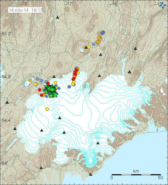
Earthquake activity in Bárðarbunga volcano for the past 48 hours. Copyright of this image belongs to Icelandic Met Office.
Largest earthquake in the last 48 hours had the magnitude of 5,4. Other than that earthquake activity is on the same level as before, there doesn’t seems to be a any major change taking place in the activity. Subsidence in the caldera continues around the same rate as before, there might have been a minor slowdown of subsidence, but I don’t know if that has changed again. Other than this I don’t have any other news to report at the moment.
Jon off topic:
Why do these helicorder traces depart from the horizontal?
http://seisan.sgc.gov.co/RSNC/paginas/heli/HELI/welcome.html
I’m not Jon, and not a geologist, but I’ve dug a bit on the web. Those helicorders are from two networks in Columbia, RNAC and RSNC. Two papers, in English, give details.
http://www.j-shis.bosai.go.jp/staff/nelson/papers/Pulido_IISEE_2003.pdf
http://iisee.kenken.go.jp/net/shiva/update/Colombia%282009S%29.pdf
I think the instruments in the RSNC network may have been changed since the papers were written, as the displays clearly have N-S and E-W axes as vell as vertical. The reason that they depart from the horizontal (I think) is that the instruments are highly sensitive, and their bandwidth extends down to extremely low frequency motions, of the order of milli-Hertz, where one complete cycle lasts 15 minutes or more.
Thanks.
Hey what’s going on? GPS seams to have a sustained big rise…
Maybe the scientists are moving it again. Joke. But it looks similar to when they did.
Mila Cam 2 are great now! Strong eruption going on…
OT but a 7.2 earthquake :
Magnitude Mw 7.2
Region MOLUCCA SEA
Date time 2014-11-15 02:31:43.4 UTC
Location 1.92 N ; 126.50 E
Depth 52 km
M 4.3
Region ICELAND
Date time 2014-11-15 10:09:48.4 UTC
Location 64.63 N ; 17.78 W
Depth 8 km
EMSC
Saturday
15.11.2014 13:26:57 64.678 -17.452 9.0 km 4.0 99.0 5.5 km NE of Bárðarbunga
Smells familiar?
Scientists of the Rosetta mission to comet 67P say that instruments sniffing the cometary halo have detected
Carbon monoxide (CO)
Carbon dioxide (CO2)
Ammonia (NH3)
Methane (CH4)
Methanol (CH3OH)
also:
Formaldehyde (CH2O)
Hydrogen sulphide (H2S)
Hydrogen cyanide (HCN)
Sulphur dioxide (SO2)
Carbon disulphide (CS2)
http://blogs.esa.int/rosetta/2014/10/23/the-perfume-of-67pc-g/
Amazing the news about the lava lake and the 100 mts heigth the crater reached recently.
Subsidence continues and M5.4 activity keeps ongoing.
We have all the ingredients to keep having surprises and keep growing the lava mess.
This eruption is very very interesting. See if we have a growing caldera for few years so results on a new beauty big one, for the next generations, not only a cracky one…
This lava lake may help to enlarge all the new crater rim further. is like the turbo for that. Keep melting…
And Bardarbunga with the cork going in…until when? do’no but is closer alltime “the collapse”.
Ok folks thank you for keep posting you all and specially Jon for his main role on it.
I will read with interest your news.
Hi Marc, the crater rim will probably not grow in height any further, as it only grows due to lava spatter eruption. Now we have almost no more spatter and the lava is just bubbling in the lava lake, rather eroding the crater rim. The crater rim is quite stable now. The excess lava is flowing away through an opening of the crater rim. As soon as enough topography has been built up through deposition of the lava flows, the lava lake will close the large opening and the lava lake will overflow to all sides, slowly creating an even height crater rim. Then the lava will overflow evenly to all sides and if that is going on for a long time, a shield volcano will develop. Exciting!
Icelandic Met Office (IMO) is getting a new super-computer in partnership with Denmark Met Office (DMI). They are going to be able to use part of it for geology data processing.
News in Icelandic.
http://www.ruv.is/frett/ofurtolva-fyrir-vedurspar-hyst-her-a-landi
Saturday
15.11.2014 19:31:26 64.673 -17.474 7.2 km 3.1 99.0 4.4 km NE of Bárðarbunga
Saturday
15.11.2014 18:21:02 64.677 -17.479 6.9 km 3.9 99.0 4.7 km NNE of Bárðarbunga
Risk of damage to plant life in Iceland if the eruption lasts into spring. Around 450 kg of SO2 go out into the atmosphere every second in Holuhraun eruption (450kg/1 sec).
More details in Icelandic (try to use Google Translate, it might not work).
http://www.ruv.is/frett/haett-vid-grodurskemmdum-vegna-goss
Jón,
It could go on for at least 728 days to have the same impact of the global climate than the SO2 from the USA in the year of 1970…if your kg aren’t short kg or other density (x kg/m3 @273 K @1024 mBar or so)
It could go on for at least 440 days to have the same impact of the global climate than the SO2 from the USA in the year of 1999…if your kg aren’t short kg or other density (x kg/m3 @273 K @1024 mBar or so)
I though it’s more dangerous for us here in Switzerland…Let’s see what’s BB doing in the near future…or did we have much higher SO2 releases at the beginning?
Do we know anything about CO2 or CO release (kg/s)?
Source:
http://en.wikipedia.org/wiki/Sulfur_dioxide
RUV kg not your kg sorry
Ummm, total release annually is relevant, how? From the question on CO2, I hope you aren’t here to spread Lysenkoism, I thought that was going to be avoided here.
There is a lot of earthquake activity in Bárðarbunga volcano at the moment. I am seeing a lot of earthquakes appearing on my geophones.
and the GPS station shows big rise.Something going on?
Was that “big rise” less than an hour and a half ago? If so, then wait anothe hour and a half before you ask again. The blue line is filtered over a 3 hour period, and does not provide useful information about anything that happened less than an hour and a half ago.
For that reason, it would be helpful if IMO could please blank out the last hour and a half of the blue line, but not the grey detail, to avoid having that trend line whip up and down like a loose thread.
Huge drop (3 meters) and a 4.8 earthquake. Seems to be outside of the range of the noise (ie the highest instant reading is still quite a bit below what the average had been.) We will see but so far the trend is continuing downward at a good clip.
If you look at the scale more closely, you´ll see it´s not 3 meters, it´s closer to 1.25 meters currently.
Trend is downward appr. 1 meter every three days, some 35cm a day. Smooth and steady she goes.
GPS down…. very deep…. like 1 meter and signal seems very stable …
4.8 by IMO but unconfirmed yet.
down 13+ m at 4:20, and …
Unconfirmed but 5.2 on Geofon
Jon, Once again thank you for your diligence in reporting and making interpretations on the data around this eruption at Bardarbunga. What I am most curious about, and don’t see anyone doing it, is are updates to the geophysical map onto which the various stars and circles are being updated and placed. I.e., in the southeast corner of the Vatnajokull glacier, and in other spots there seems to be changes that would be of interest as to the thickness of the ice, or it changing to water. It seems to me that some parts of the Vatnajokull glacier are becoming alarmingly thin, yet the pictorial we see of it does not update or reflect new realities as it should. Is that because it is impossible?
Wendy, haven’t you made a spelling error?
There is nothing happening in the southeast corner of Vatnajokull. Bardarbunga is placed in the northwest corner of Vatnajokull, and the earthquakes are taking place all around its caldera edges but mostly in the NE corner, followed by its SE corner.
For the ice to melt significantly there needs to be an eruption. 700 meters thick does not melt quickly with just geothermal heat. The GPS in the top of the ice shows a decrease is mostly linked to caldera bedrock dropping rather than ice melting. That on itself is a big event.
Also I haven’t clearly understood what you want to ask. Maybe you can rephrase your question! 🙂
Not totally off topic
Major eruption on Bearing straight
On Mila 1 very bright red clouds at the moment. Some strange kind of scenery. On Mila 2 some clouds obscure the view to Baugur. These clouds don’t look like normal clouds, rather like clouds from eruption or water/lava interaction. What’s happening there? New vent opened to the northeast of Baugur? Worth a look!
Can’t say I’ve see it look like this before!
All quite odd. I too don’t recall the view looking like this before either.
It does look strange at the moment. The glow is on the left, I hope the clouds clear soon so we can get a better view.
Looks like that cloud isn’t going to budge just yet!
Yep I just thing it is the reflection from the lava lake, just reflecitng off the clouds
Sunday
16.11.2014 19:27:53 64.676 -17.354 7.6 km 3.6 99.0 9.2 km ENE of Bárðarbunga
Sunday
16.11.2014 19:24:12 64.671 -17.471 7.9 km 4.1 99.0 4.3 km NE of Bárðarbunga
You really don’t need to post every 3 or 4 quake. We can see them just fine on IMO.
Tyler we have answered your statement before.
Some of us enjoy reading and seeing all the quakes, you don’t have to look if you don’t want to.
I really don’t know why you are so harsh with me… but ok, it’s your problem. Any VC resentment? Here i only get directions from John.
I agree with you Tyler, but …
On Mila cam 2 you can see increased activity. The latest video and photos from last week show a lava lake bubbling which does not reach the heigth of the crater rim, with occasional rare spatter. Now are visible constant large lava bubbles or even fountains which are much higher than the crater rim, in three places. That is a clear sign that extrusion rate has significantly increased. Let’s see what happens next. Maybe the large low clouds are from lava/water interaction from a large lava flow entering Joekulsa a Fjoellum river?
Sorry Stefan posted before I read your post , you have answered my question.
I must agree Stefan it does look more active tonight, but there again we have not had a clear view for the last few days, plus all this low cloud does not help, but as you said it looks like more lave is being ejected at the moment.
To the left of the cam in the background are there now new eruptions showing ?
No, that is the lava river which is partial hidden by the steam from the lava field.
It definately looks like smaller eruptions to me ?
You can look here and compare what you see today with some days/nights in the past.
http://www.brisske.de/Fotos/Public/index.php?AlbumDir=/Fotos/Public/BARDARBUNGA-Screenshots
Sorry off for being off topic… Not Icelandic but this is one certainly has my attention, it’s earthquake activity is in a leauge of it’s own.. not even bardabunga can catch it.
It’s all been happening at the ‘Chiles-Cerro Negro’, from the little I can find it’s a pair of stratovolcanos located high up in the Andes between Columbia & Equador.
Since 29 September 2014 about 132,000 earthquakes had been detected, with 3,200 of those events occurring on 4 November.!!
http://www.volcano.si.edu/reports_weekly.cfm#vn_351110
Ecuador (sorry)
Just being reported now. Mag 6.8 170km off the East Coast of New Zealand. Too early for a Tsunami warning.
Sunday
16.11.2014 22:27:01 64.616 -17.445 3.9 km 4.8 99.0 4.8 km SE of Bárðarbunga
There is an interesting line of flaring in the centre foreground on Mile Cam 2. Is it a new run of lava? The number of flares are varying but over the last half an hour or so, it has appeared to be increasing slightly.
Lots of changes to the crater profile since I was last able to view it.
The Lava flow is certainly greater than I last saw it.
I thought I was seeing the same thing, but then I minimized the screen, which on my computer stops the action. I waited about four minutes and started it up again and then could clearly see that the “lake” in the foreground is reflecting the eruption site as the cloud movement could clearly be seen in the foreground glow mirror imaging the sky clouds. I don’t know what is causing it to happen only in that particular spot, though. Awesome!
Thanks SusanonKauai
What are your thoughts on the line of flares beginning right above the a on the Mila Logo. They appear to be between a third to half way to the main Lava field. Kinda look like a line of flashlights or street lights. I am wondering if that is a Lava front heading towards the camera.
You and I think alike. I also spotted those awhile back and watched them for hours before I realized they were just little twinkles from the edge of the lava flow. It doesn’t take much at night to look like something quite spectacular might be popping up. They come and go. Happy watching! (Like me, you must be in a “not usual” spot on the planet. Who else is watching in the middle of Iceland’s night?!)
There seems to be some ice reflecting back the light from the eruption. If it is not ice then there is unusual high amount of water in the area. That might be due to small eruption under the glacier, but we need to wait for daylight until it is confirmed. There is no way for to tell the difference at the moment.
I also don’t know if the eruption is more powerful then it was before or not. It might be and it might not be. All that can be done is to wait and see what the report says in the morning about this.
Been following the blog since late August, thanks Jon for the forum and guidance as well as to everyone else as I enjoy the varied input, speculation, and the agreeing to disagree until more data becomes available. I’ve learn a great deal.
Regarding the latest Mila 2 image ( it’s been a while since I seen one), the fore ground reflection is very interesting. I don’t recall seeing it in prior weeks. As Jon mentions we’ll have to wait until daylight, but it sure seems to be running water in an area that may only have a seasonal stream from glacial runoff. Certainly it could be ice playing tricks with the lava and clouds, or pixilation due to the low light, but water where it wasn’t before may be the beginning of a new chapter.
Thanks all again for the great discussions over the past few months.
Thanks Jon. I remain fascinated by your page and am very greatful to you for sharing your knowledge.
Susanonkauai. Yep. When I wake up it is getting dark in Iceland and I am more used to reading the night time screen than the daytime one. By all means click on my link and add me up. I am always delighted to chat with interesting people. I am the ‘Mike’ linked to the page.
I know we have to wait for tomorrow’s data, but tonight the eruption seems particularly large — lots of that super bright white going high into the air with the buttercup yellow (sulphur dioxide?) in huge amounts compared to recent nights. Maybe part of the crater wall collapsed so it just appears bigger, but the part of the eruption that’s visible seems at least ten times more intense than the past week or so.
Mike, I don’t know how to do links! I barely learned how to post here…
Jon, thank you again for your wise observations and consistency. I’ll try to send another donation soon.
Susanonkauai. I have changed the link from my business page to my personal Facebook page. Welcome to add me if interested.
Remember my shield volcano theory? I know most people were not convinced when I first said this in August (before the eruption even started) and in September (as it started as a fissure). But this is a shield volcano so it builds layer upon layer, over a long period of time.
After it start in the context of a regional rifting event (grabens, fissure appeared), but it has been turned into a single vent over a long time, and now forms the typical large crater,/ lava lake, of the typical Icelandic shield volcano type of eruption. It is the first shield volcano in Iceland since year 900, that being west of Langjokull.
The lava will flow in most directions, except not so much south, because the terrain gets higher there. This shield now flows over southeast, then northeast, and then again northwest.
The volume is now probably around 2km3, but it seems it will get even larger. Shields in Iceland often get up to 5km3, and the largest shields are about 30km3 and occur over decades. So this eruption has been ongoing for 3 months but it will likely last many months to a couple of years. Thus don’t be surprised by it.
This shield volcano has now probably around 200 meters above the surrounding plateau (100 meters of crater plus 100 meters of highest lava thickness). Largest shields go up to 600 meters above the plateau.
All of this occurs in context of a regional rifting event that takes place every 130 years (cycle more or less with that period). As last cycle occurred with Askja rifting, this cycle is taking on with what the last cycle started: rifting has now occurred over the entire extent of the eastern volcanic zone, as this zone was one of the few that has not experienced regional rifting since many centuries. This is why we were observing all those quakes at Kistufell in the past few years.
Be excited by enjoying this unique event.
Irpsit, you have the ownership of the shield volcano theory? Congratulations. I joined this blog later and so never got to read your theory. My first comment here was, that if this is going on like that, we are looking at the birth of a typical Icelandic shield volcano.
This is not yet a shield volcano. But it’s on the way to become one. It’s not a single vent, it’s 3 or 4 vents which are located close to each other and now combined in a lava lake with one large outflow opening. It did not yet form the typical lava lake typical of a shield volcano. That would look like a roundish lava lake with lava spilling to all sides. We don’t have that yet.
Don’t know about your abilities in mathematics, but the highest point of the Baugur volcano is about 100 m, the highest point of the crater rim. It’s extruding it’s lava on a shallow plain. So the hight is max. 100 m, not 200 m (???).
I’m also very excited about this event. In 1992 I cycled through Holuhraun area and was asking myself how an eruption would look like producing these huge lava fields. Now I know 🙂
This is not going to turn into a shield volcano. Once this stops erupting it is not going to erupt again. Shield volcanoes have there own magma source that gets renewed over time for millions of years. This is not the case here since this is a dyke eruption from a central volcano.
Stefan: I had this theory back in mid August, as the swarm started. I suggested this by merely observing that the Holuhraun/Kistufell region (towards where the two dikes were heading) had several shield volcanoes around (Trolladyngja, Urdarháls, Valdalda, and others further north) and no evidence of long fissures like it happens in the dead zone southwest of Vatnajokull,
I suggested that the dike might instead of erupting in a long Laki-like fissure, rather on a shield volcano type of eruption, like Trolladyngja.
Also because I see that in many millenia, we seem to be at a stage of increased activity in the eastern volcanic zone of Iceland, between Bardarbunga and Tjornes, with eruptions at Askja, Krafla, where no significant activity took place before the 18th century (previous major episodes at those volcanoes go back a few millenia). Then I foresee that a large shield volcano type of eruption was going to happen, precisely at Holuhrain. I am not bolstering myself, but I just happen to be lucky with my educated guess (which I wrote in VC blog at that time)
Shield volcanoes in Iceland are not like shield volcanoes in other countries. They build layer upon layer but they tend to be oblong in the alignment of the rifting, sometimes have more than a vent and often erupt only half of a shield shape, because terrain might be already on a slope.
At least GVP classifies many of the Icelandic “shield volcanoes” as shield volcanoes.
Jon: What about Skjaldbreidur, Trolladyngja and all those minor shield volcanoes along Reykjanes, Hengill and Langjokull region? They are a one-time eruption, a dike that originated from a central volcano and they are classified by shield volcanoes by Icelanders. Obviously they are of a different genesis than say Hawaii or Canary Islands. If you see Skjaldbreidur its a rather similar setting as Holuhraun (a dike coming from Hengill, along the rifting graben, with minor eruptions between the shield and the central volcano).
I think even if we debate this here and we are not sure about this event yet, I think that time will give me reason on this one.
I don’t think those are actual volcanoes. They are eruptive vents as such. A volcano needs to have magma chamber to be classified as one.
The eruption in Holuhraun is a normal fissure vent eruption with spatter cones.
http://en.wikipedia.org/wiki/Fissure_vent
Trölladyngja is a volcano in it’s own right (maybe). It is not marked as a volcano on my geology map that I have.
Hi Jon, I would say that it has it’s own deep source which goes through the magama chamber system of Bardarbunga volcano. A shield volcano doesn’t care from where it gets its supply. Large basaltic effusive eruptions with large covers of lava sheets mostly originate from fissure eruptions (flood basalts), and they need a deep constant supply of magama over a long period of time (no magma chambers involved). I would say, if this keeps on like this, we will have at the and the shape of a shield and that’s why it then can be called a shield volcano. Just looking at the latest mila 2 cam we can observe that a slight slope has been built by the lava sheets, from the outflow point of Baugur towards the lava fields. One month or more ago, we could still see sort of a lava river (with canyon cutting through older lava sheets) with rapids and shallow lava falls because of steeper topography. That is levelled out now. Next phase will be that the lava lake will be closed at the current outflow point, then rise to the next outflow at lowest point of the crater rim.
The thing that would work against the development of a shield maybe the very low magma viscosity,the lava will tend to run away from the vent for a considerable distance.
Also, Bardarbunga may become less cooperative. It might decide to divorce Holuhraun and go its own way.
I thought that divorce was forbidden in Iceland.
JB, the characteristics of a shield volcano is low viscosity lava travelling long distances at the beginning, then spilling low viscosity lava from a central lava lake, smaller amounts but still travelling a couple of kilometers. Just have a look in google earth at Troelladyngja. Under the shield you can see long lava flows from the beginning of the eruption, then shorter lava flows building the shield. If Baugur continues like that, it will look identical. Just compare the scales of the two events. Quite similar.
Stefan let me know in another 5 years when the shield is formed by this event,the most likely scenario is the eruption will stop with a large lava field,or it will be over topped by a massive glacial flood and or buried by a Pyroclastic flow from the caldera.
I think perhaps the flank has collapsed. There seems a faster flow of lava as though is has.
I would tend to agree with you. I am in Australia and leave a couple of related pages including Mila Cam running in the back ground. During the day there was some extreme lava action. There is a valley some way to the right of the current eruption which had a large lava flow for some hours- If you look at cam 2 you can still see smoke rising from there but several hours ago it was white hot and quite visibly moving through that valley. Although I have not been able to view cams for a few days, I noticed a number of unusual events throughout the day. More notably- If you look at my previous posts, were a number of flaring events in the central left foreground- These have continued throughout the dawn. I will be fascinated to see what they turn out to be.
Pic from 0747 this morning –
http://snag.gy/sQNsh.jpg
Yes I think I agree with you guys,
That steam over the NW flank of the vent is something new. I think the flank collapsed and lava might now freely run north, northwest and west.
You see that lava will basically flow in all directions, according to gravity.
Long term raw data from geophones:
Jón do you share your webicorders long-term (1 year) tremor data? As CSV files?
Would be nice to get a link to your ftp server or something like this?
The software that I use does not support CSV format. I also only store raw data for 60 days.
60 days are OK a good start, the data files (psn/h5/dat/txt/etc.) are OK, as long we know which kind they are 🙂
Would be fun to have the two from the last two months…
Do you use a cloud or ftp?
Here are the earthquakes that I have recorded since August until today. Not every earthquakes here are from Bárðarbunga volcano.
http://www.jonfr.com/webicorders/earthquakedata/
This rar file contains ~3000 files / ~1000 earthquakes (three files for each geophone). Some events might be missing since I have processed them and moved to a different folder on my earthquake computer.
🙂
THX
For all who like to open the geophones raw data:
http://psn.quake.net/software.html
What I see is: There is one or two new vents on the right and in front of the old ones developing (Mila2). There are two new sources of steam or smoke in the center of the lava field on Mila1. Is it water coming in? Anyway, there is a lot of water surrounding the lava field, whatever it means. From melting snow? From the glacier? And one 3-4 eq after the other in the last hour. A lot of action at the moment.
Lots of tightly time clustered eqs > M3. Somethings failing or interacting differently.
Regards the new vents, Ive been 300% zoomed on these for a while and whilst it is daylight its difficult to be sure, but it appears to be low fountaining –
http://snag.gy/URu65.jpg
Wow you can see all that in that picture?
🙂
My old latin teacher used to tell us before every written exam:
“There is somebody seeing everything and hearing everything – that´s god. And there is somebody seeing and hearing almost everything – that´s me”
🙂 🙂 🙂
Wow can you read, I said its difficult to be sure in daylight. I was watching it in response to two other people who post in here, live out there, and have already said they there had been a change.
I was watching moving pictures not the still I captured. This is a place for people to share what they observe and think. If you have difficulty with me take it up with Jon. I’ve been posting on his site for several years and he has never had recourse to object to me.
It was JR who said, “What I see is: There is one or two new vents on the right and in front of the old ones developing (Mila2). There are two new sources of steam or smoke in the center of the lava field on Mila1.”
And he has the cheek to come back at me too.
ScotsJohn,I was just joking,you could be right but it’s hard to tell from those cams.
Ok will leave it there then.
I realise the picture is blurred at that zoom, but it was apparent there was activity in the live footage.
Since seeing the RUV footage Mafl posts below it looks like it is a branch of the lava river that is responsible for this.
1. I thought that JB was refering to my posting.
2. My comment was self-ironic meaning that I do not take myself too serious sometimes.
3. Apparently, some people are taking themselfes very serious. Unfortunately.
Nice to have a look at the eruption site again. But in my opinion there has nothing changed…
Mila 2: There was a lava flow in front of the main vent since weeks. And sometimes it “bubbles” up and we can see the fire. But thats no new vent…
agree 😉
Me too!
Only things that changes are the light- and weather conditions. Therefore the eruption LOOKs sometimes so and sometimes so.
New picture from above:
https://twitter.com/Icelandair/status/507259814628851712/photo/1
One little lavaflow to the left (NW), a greater one to the left (S-E) and a great flow in the middle which feeds/thickens the hole field and is responsible for the steam at the field.
For comparison:
http://en.vedur.is/media/jar/myndsafn/full/Yfirlitskort_20141114.jpg
Sorry, “whole field” 🙂
Again sorry, seems the picture is older!?
The photo is old! is from 3 september!
from 13:12 – 3. Sep. 2014 ??? new?
Corrected! 😉
Yeeaas! I knooow it now…
It was from a tweet from today and as I use the original tweet from icelandair, I saw it to late 🙂
But really: I don’t think much has changed… a little bit of snow…perhaps a little bit more lava splashing from the lava lake(s) …
IMO says: “The eruption was well visible on cameras throughout yesterday. It continues with comparable force as in recent days. No changes are visible or reported from the field.”
http://en.vedur.is/earthquakes-and-volcanism/articles/nr/2947
But this should be a new video from today 🙂 ! And it’s amazing:
http://www.ruv.is/frett/holuhraun-eruption-fresh-video
You can see the lake and the out-flow of the lava.
Very good, seems the ‘new vent’ may just be a branch of the lava river?
Yes, and perhaps a reflection in the snow/ice in the foreground. For me it’s the first time I’ve seen this.
New article is up on the eruption in Holuhraun and what is happening in Bárðarbunga volcano.