
Bad weather in Iceland has been making monitoring of Bárðarbunga volcano difficult at best. Information for that reason is a bit limited at the moment.
Earthquake activity continues in Bárðarbunga volcano as it has been doing for the past two months. Largest earthquake this morning had the magnitude of 5,4 and happened at 07:11 UTC. Other earthquakes have been smaller, due to bad weather in all of Iceland fewer earthquakes have been recorded today and yesterday (06-November-2014).
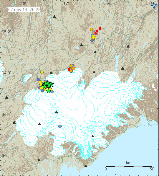
Earthquake activity in Bárðarbunga volcano for the past 48 hours. Copyright of this image belongs to Icelandic Met Office.
GPS measurement are showing that subsidence in Bárðarbunga volcano continues at the same rate as before. The rate of subsidence is the same, the change however is that larger area of Bárðarbunga volcano has now started to drop, suggesting that current eruption in Holuhraun has started to drain magma from other dykes in Bárðarbunga volcano or sill in it. The details of this can be found here in latest report from Icelandic Met Office on current activity in Bárðarbunga volcano.
No change has taken place in Holuhraun, the eruption continues with same rate as before far as I know. Bad weather has blocked the web cameras and I don’t think there is anyone close the eruption site due the weather. Far as I know there is nothing else in the news about the activity in Bárðarbunga volcano.
Donations: Please remember to donate to support my work or by using Amazon to support my work by shopping with them. Thanks for the support. 🙂
Friday
07.11.2014 22:04:30 65.000 -17.260 5.7 km 3.9 50.5 11.5 km N of Trölladyngja
Low quality still. But I am curious to see where its location is.
I think it might be just another caldera quake. Let’s see.
I think so, the other time IMO give this location but change it to caldera when they manualy review it.
@Jon, are we really sure about “larger area of Bárðarbunga volcano has now started to drop, suggesting that current eruption in Holuhraun has started to drain magma from other dykes in Bárðarbunga volcano or sill in it” ?
The report does not says that. Merely says, that other data shows that subsidience continues at SAME rate.
“Other measurements do though show that the volume of the subsidence increases with the same rate as it has done since these measurements started in September”
We do not seem to have access to that data, so we can’t elaborate on that. Do you have access to that data? How come do you suggest that other regions have also started to sink? Which data supports that? Even today the IMO suiggested on Facebook a funny prediction of the subsidience rate decreasing pointing to an end of the eruption by February.
@JB: I was curious on your theory. Do you want to elaborate further?
“Hotspot magma plume rising to meet evolved and partially evolved magma chamber under Bardarbunga causing this magma chamber to expand ,particularly to the NNE .This is deforming the caldera floor and contributing to the eruption at Holuhraun,a large eruption at the caldera would be impossible to predict and is not certain to occur?”
@Kolla, I read your reply. Sorry if I came up against your point of view in a seemingly forceful way. In my original post I was suggesting that “55 times” was the total volume of Bardarbunga caldera (in fact it is more), but that volume would NEVER erupt all in a single time, That volume of the caldera is volume drained into rifting eruptions over thousands of years, over many many events, possibly dozens or hundreds of them. And on the practical side of worry, I wouldn’t worry that much about a possible large ash eruption there, unless you would live in the north/east of Iceland, or it would affect the power grid in the southwest. Where do you live in Iceland?
I know the report does not say that, but the GPS data (http://strokkur.raunvis.hi.is/gps/#VATN) suggest this is happening. At the start of this eruption (16-August-2014) at least two other dykes formed in Bárðarbunga volcano. They did not erupt and might not erupt at the moment.
There is also data now suggesting that internal structure of Bárðarbunga volcano is far more complex than current model allow for.
I have never based my views only on reports from IMO, Almannavarnir and other. I do check the data when I can too see what is happening when a eruption is happening in Iceland. It can take me few days to figure out what is going on at times, when the data set is extremely complex and hard to figure out.
The GPS station at the centre of the BB caldera has stopped transmitting data.
http://en.vedur.is/earthquakes-and-volcanism/gps-measurements/bardarbunga/caldera
“No data from 7 November, the antenna might be covered by snow.”
http://xenon.colorado.edu/spotlight/data/p698/eo/scienceImage4.png
The camera is covered with snow (Bárðarbunga 1 & 2) and they are lower than the GPS station in the caldera.
Gps is back
Irpsit the theory I have is over centuries basalt rising into the caldera mixes ,evolves and tends to spread out to the rim and beyond?Some of this is extruded as viscous lava flows at the rim under the ice and there would be various basalt eruptions in the caldera and outside of it as basalt migrates through fissures in the rock,but at some point there maybe quite large deposit of silica rich magma in place,then if a rifting event enables a large intrusion of basalt to rise in the system then the process of heating of this evolved magma is accelerated and is that what we are I now?This then creates the potential for a perfect storm situation to be possible ,of a large enough deposit of silica rich magma,temperature,pressure and gas content and from this would occur a caldera event,but all the” ducks have to be in a row “for this to occur,so it is no means certain to occur even if this situation is present,this not an easy to erupt scenario,hence all the large earthquakes without eruption in the caldera.
Logic would tend to suggest,because large caldera events are infrequent,that these systems do not erupt easily,they are huge energy reservoirs that work quit efficiently most of the time dissipating geothermal energy,through earthquake swarms,hydrothermal activity etc,until sometimes something goes wrong and starts a cascading system failure leading to a large eruption.Maybe a system like this in Iceland has the glacier as an extra fail-safe and this extra energy dissipation system is magnifying the earthquakes and keeping the system under control?
This question for Irpsit:
If you check the GPS chart for Grimsvotn, you can see the obvious, that an eruption occurred when the peak of the cycle is reached. Would you agree that we seem to be heading into another such event within about a year?
See http://strokkur.raunvis.hi.is/gps/GFUM_08.png
This is not an answer to your question, if you look at
http://strokkur.raunvis.hi.is/gps/GFUM_rap.png
do you think that a peak is reached?
The peak is not reached. The GPS for yearly data needs to be examined. It is obvious from that, that the elevation changes in an interesting repeatable fashion.
What about this one?
http://hraun.vedur.is/ja/vatnajokulsvoktun/grf_uppsafn.html
But note that it is Grimsvötn not BB.
There is some acceleration starting roughly around the beginning of the BB EQ’s, nothing like the green or blue lines.
Yes, I know.
But if we look at the red line, we have more than two years (if not something specials appears…) not next year…
Correct?
It’s impossible to say if something special will appear….
JB: Bardarbunga-Veidivotn has actually been the second most active volcanic system in Iceland during the Holocene, as shown by the number of (largely basaltic) ash layers preserved in soil profiles around the margins of the Vatnajokull icecap (1 to 8 per century over the last 7600 years, average 5). Most of these are thought to have been produced by subglacial eruptions rather than subaerial fissure eruptions. See abstract by Oladottir et al. (2011), as well as earlier papers by Bjornsson and Einarsson (1990) and Thordarson et al. (2007), available from:
http://earthice.hi.is/bardarbunga_2014#Publications
Icelandic central volcanoes and their associated fissure swarms situated on the actively spreading Eastern Volcanic Zone/mantle plume do not behave like calderas elsewhere in the world. They are a law unto themselves, and the precise mechanisms of caldera formation appear to be complex and still poorly understood…..
There is quite a bit of difference in volcanic activity in the various countries in the “ring of fire” and that is all subduction volcanism,so yes not all calderas are the same but some principles must be,for example long repose times between eruptions?
Basalt in ash layers are more common because that is 90% of eruptions in Iceland and all the explosive intermediate events in the caldera will be mostly basalt,but the question is are the caldera forming or caldera enlargement events basalt driven or do they require more evolved magma?
Both?The icecaps make Iceland’s volcanoes unique. With small eruptions cause sub-glacial lakes. When a large enough dike erupts under the ice, ice becomes enormously explosive as superheated steam. A steam explosion is then followed by a second, even greater explosion of gases and dust.
This could be an interesting scientific paper in this context: http://pages.uoregon.edu/bindeman/GeyerBindeman.pdf
In that paper,chapter 4.3.3 might be quite relevant to what is happening.
I get does the paper infer that glaciers suppress activity and allow the build up of more evolved silicic magma in the shallow chamber,leading to an enhanced eruption eventually?That paper is a must read for anyone following this event!
ML 3.5
Region ICELAND
Date time 2014-11-08 19:00:51.9 UTC
Location 64.67 N ; 17.48 W
Depth 1 km
EMSC
Dr. Anja Schmidt @volcanofile · 3 h Há 3 horas
Icelandic gov invests €4.5M studying potential long-term health effects from Holuhraun sulfur emissions. #Bardarbunga http://icelandreview.com/news/2014/11/05/long-term-effects-eruption-pollution-be-studied
The gas went south today: http://www.vedur.is/vedur/spar/gasdreifing/
There were measured 2.700 µg/m3 of SO2 in Vík í Mýrdal http://www.ruv.is/frett/gasmengun-maeldist-2700-i-vik-i-myrdal and 3.100 µg/m3 of SO2 in the Vestmannaeyjar (Westman Islands) http://www.ruv.is/frett/mengun-for-yfir-3000-i-eyjum .
Another big quake coming up this minute close to 5,0
Yes IngeB,
Rather hellish here. East of Selfoss.
Levels not only around or above 3000 ug/ml, but as I went to Reykjavik I forgot and left windows of house opened. As we returned home, fog appeared suddently, and of course air was heavy, dirty, smoky.
And oh shit, air inside our house is completely similar. Because we let windows opened. After a bit, start feeling the breathing disconfort. The dirty air feel is everywhere in the house.
Now, what the hell should I do? Put fans blowing baking soda, sprayed it everywhere, but it still feels like that. Any advice?
Turn on the shower and use cold water, wet towels and such with cold water. This binds the SO2 with the water vapour from the air and cleans it.
I have been doing this 30min and the air still feels the same. Wonder how long it will take to take levels to a level that I don’t feel this heaviness/smokiness.
Yup, this was a serious mistake we did. Ahh, I resorted to be breathing inside my own house with a mask soaked in baking soda.
You need to get the air inside the house on the move, a circulation. A fan would do the trick.
Thanks Jon.
You’re very kind to offer help.
Obviously this was a harsh reminder that it’s NOT NICE to forget windows opened when the gas pollution was coming. This is a subject not to be taken lightly as it really makes your life miserable if you don’t have access to clean air within your house when things outdoors go polluted.
I was just too distracted with other things and I totally forgot that the gas pollution was coming our way.
People at Reykjavik: according to forecast this is coming to the capital area tomorrow or later this dawn.
On my gas drama tonight, well all is much better now. The shower, baking soda spraying, all have relieved a bit of the smoky feel indoors. Nott totally but certainly down to an acceptable more confortable breathing level. Still unhealthy but not causing me immediate disconfort at least!
Holuhraun. Must be a hellish place this night:
This is like living 200km downwind of a place that emits more SO2 than the totally of Europe combined together. And it is just a small hole. I can’t imagine how badly it is to be over there:
– totally poisonous atmosphere. Will kill you quickly, if you dont have a gas mask.
– hurricane winds as of tonight, and freezing cold
– pouring 1200ºC hot magma for many dozens of square kms
– earthquakes M5 every few hours
Seems like the craziest spot to be on the planet.
So sorry that you have such bad air, Mr Irpsit & family. Glad that is a bit better now. My offer still stands for you and your family if you wish to go to a warm place with better air.
No problem. I am moving away from Iceland in early 2015 actually. But due to other reasons. But I am not going to miss the volcanic gas pollution but surely I will miss of the extremely clean air at normal times in Iceland.
Hope you are all ok, no lasting effects we hope. Have to be more careful, that stuff is very bad news and will make you ill. Keep well.
Perhaps A/C would help air if available say after running heat
There is a nice view on Cam 2 this morning, I hope the weather stays fine today.
Sunday
09.11.2014 08:56:07 64.677 -17.464 7.6 km 4.4 99.0 5.1 km NE of Bárðarbunga
A bit better this morning the air, but woke up with bad sore throat and chess small pain. My girlfriend has numbed or tingling nose and irritated throat too. Quite nasty this night with a house with SO2 smog indoors. Lol.
Now levels a bit better outdoors, waiting for fresh air to have some deep deep breathing.
I suspect that an eruption might have started under the glacier. I am waiting confirmation on this. I don’t know when I get it, that might take a while.
Is it possible for us to see/follow signs somewhere (tremor/gps etc.) ?
You can see the tremor plots here.
http://hraun.vedur.is/ja/oroi/index.html
The earthquake data here.
http://en.vedur.is/earthquakes-and-volcanism/earthquakes/vatnajokull/
This was at least not a big eruption if it was that. Other possible explanations are that the hydrothermal systems in Bárðarbunga volcano are increasing again resulting in overpressure that create this type of tremor.
I miss an article about how you read what data to suspect an eruption. None of data I know shows sign of an eruption. Such an article would be more interesting than a “nothing changed”-article about Bardabunga.
I meant something like GMK. I know these links since 2010, but I can only sometimes see after an event, that something has changed before. So it would be nice, if you can say perhaps something like “tremor at grf at around 15:00″…
I know you are looking with an deeper understanding at the tremors as everyone here. 🙂
I can see an upward spike in the tremor plot and see what it means. The problem now is that such spike is often lost when the tremor plot is updated, due the constant activity in Bárðarbunga volcano.
Thanks!
Only one spike? I will never learn that… 😉
The hydrothermal explanation seems the most probable cause,as the ice melts the suppressive effect of the glacier diminishes?
Jon – It looks from the earthquake cluster on today’s IMO earthquake map as if an intrusion (dike?) might be starting to form on the NNW flank of the caldera where the outlet glaciers are small and steep – how does it look to you?
No, I don’t think there is any dyke formation taking place there. Such magma movement would have rather direct path to the surface due to fracturing of the crust in that part of Bárðarbunga volcano.
@Jón you look quite busy today…but if you are in a good mood, isn’t that a problem at all:
I’m wondering about all the sharp spikes on your Webicorders since yesterday, some are on both (for ex. UTC ~13:27), a few on Böðvarshólar but on Heklubyggð they are nearly uncountable.
It’s for me not the typical wind related signals, if I would guess: Thunder signals?!? Thunderstorms are common in Iceland – daylong?
This is just human made noise. People close to the area where my geophones are located. Thunderstorms are not common in Iceland.
@Jón I like to learn more:
Why are some EQs (or a part of it) on your geophone records red and others not?
Red earthquakes are automatic saves in my earthquake detecting software. If earthquake is not red it was not saved automatic.
@Jón
RedPuma?
Rapid earthquake data to Pagers, users, e-mail recipients, and authorities?
http://www.seismo.ethz.ch/sed/archive/2005-2009/redpuma/index_EN
I don´t know what the spikes in the Webicorders mean, I was wondering about them myself, but thunderstorms are rare in Iceland and if they occur, they tend to be short lived. So I think the cause for the spikes has to be something else.
Oh well, Jón already responded.
THX – surprising solution
Sunday
09.11.2014 17:09:33 64.670 -17.510 1.1 km 4.1 50.5 3.4 km NNE of Bárðarbunga
Are these tectonic earthquakes in front of a background of volcanic tremor? With additionnally a lot of small long period events? http://hraun.vedur.is/ja/drumplot/dyn.png and http://hraun.vedur.is/ja/drumplot/von.png
Doesn’t tremors look more like this in the first hours of the day…or do you mean something else?
http://hraun.vedur.is/ja/drumplot/vot.png
It depends on the calibration, I think, but I don’t know how the calibration is of these drums. It seems the different drums on all these drumplots differ in this much from each other, and perhaps also from other periods on the same drum during the same day …
I see Big B still rumblin-n-grumblin. That’s one tough volcano!
They are now preparing for massive power outages in Iceland due to glacier flood from Bárðarbunga volcano. The glacier food needs to go south-west for that to happen. If it goes somewhere else the chance of damage is far less.
That is the opposite direction of IMOs Jökulsa a Fjöllum flooding map some days ago. How do “they” come to that surprisingly conclusion?
I thought the bedrock of BB-caldera is at lowest to the east side?
Bárðarbunga volcano is in a area that covers three or four water areas in Iceland. Water going to the south Iceland is just one of the path it can go if an large eruption under the glacier happens.
Not surprising at all. There is eg. Hamarinn, part of Bárdarbunga volcanic system; a small glacier run from Hamarinn in 2011 went into Kaldakvísl and from there into Þjórsá, the biggest river of South Iceland.
There has always been this danger that melt water / jökulhlaup from a eruption in Bárdarbunga could go different ways at the same time. There is just that much ice in all directions on this volcano that it would probably also melt at different parts at the same time in case of eruption. Weeks ago, the Icelandic glaciologist Henri Björnsson expressed his concern about melt water running down to the west and rather fast also, because of the steepness of the caldera walls in this direction.
This report is from a risk insurance and the Icelandic Civil protection, it is in Icelandic, but shows maps with the different possible flood paths and regions which would be influenced in case of big jökulhlaup. See esp. pp. 15, 16, 18 and 20.
http://avd.is/is/wp-content/uploads/2014/11/Greining_a_ahrifum_floda_i_kjolfar_eldgosa_i_Bardarbungu_utgafa_2.pdf
OK, I have to get used t0 the massivness of that volcano. Thank you both.
In my opinion, there is always an eruption in one part of the caldera (north-east). But BB collapse as a whole, I didn’t imagine yet.
This was the plume of the Grímsvötn 2011 eruption covering a big part of Iceland. A big eruption in Bárðarbunga could dwarf this one … https://commons.wikimedia.org/wiki/File:Gr%C3%ADmsv%C3%B6tn_Volcano_Showing_Plume_-_May_22.jpg
Large earthquake just happened in Bárðarbunga volcano.
Magnitude 5.0
Region ICELAND
Date time 2014-11-09 21:19:42.3 UTC
Location 64.43 N ; 17.86 W
Depth 10 km
http://m.emsc.eu/earthquake/earthquake.php?evid=407850
FWIW, I get a DANGEROUS SITE warning from my VIPRE antivirus/antimalware software to that link.
Don’t know why.
Jon,
Why are they preparing for a glacier flood now? I thought they had prepared for a flood weeks ago? Do you think the IMO restrict the information they post?
They have been preparing all along. They have covered the most likely scenarios, made calculations and simulations etc. It´s a continued work in progress. In the beginning it was about making sure they could evacuate local residents. Saving lives is a first priority. The second concern was to protect power stations from damage. Now they are beginning evaluate the global effect of having to close down several power stations at the same time (40% of the overall power generation) and the risk of losing power lines as well. This could result in power shortages for an extended time. So they are also warning businesses to make sure to prepare for that kind of situation.
If there will be a melt water flow it will use the easiest way out. Is there a 3D topography image available of the BB caldera? Then we could see where the lowest point of the caldera rim is. But it also has to be at the “open side” of BB, towards the sander and old lava fields to the northwest. When it would break through somewhere there, the flow rate would increase with erosion of the caldera rim, maybe releasing a large portion of meltwater which accumulated in the caldera bowl. But Jon, what makes you say that the authorities are preparing now for power cuts caused by melt water flood? If they do this now, there might be a reason for it. Heavily increased EQ activity? Hydrothermal activity increased? You mentioned the latter quite often. Can you please explain the signs for hydrothermal activity of BB? Enlargement of cauldrons?
Jón is just citing Icelandic news (national television RÚV): http://www.ruv.is/frett/vidbrogd-vid-storflodi-i-thjorsa-og-tungnaa and http://www.ruv.is/frett/fyrirtaeki-gera-vidbragdsaaetlanir
I think these preparations – some of them are starting just now additionnally – have to do with the last factsheets. http://en.vedur.is/media/jar/Factsheet_Bardarbunga_20141107.pdf
The risk of massive flooding from Bardarbunga into both north of Iceland, along Jokulsá river and Godafoss river, southwest along Thjorsá river
It’s just information that was throughly studied and compiled in this fabulous detailed but scary official report from the Civil Protection. Thanks Ingi for sharing this.
http://avd.is/is/wp-content/uploads/2014/11/Greining_a_ahrifum_floda_i_kjolfar_eldgosa_i_Bardarbungu_utgafa_2.pdf
On the north the flooding might cut two river bridges along the ring road, and a powerline between the east and the north. Also might flood some farms along the seaside near those two rivers. But they would have time to evacuate, about 5 hours, unless flooding starts when people are sleeping early in the night.
On the southwest, the predicted flooding is rather surprising. Near Hrauneyjar, damaging not only the road,but also the dams and about a bit percentage of Iceland powergrid. Then, the road near Thjorsádalur, and then the road between Selfoss and Fludir, and then south of it down to the south coast, which is very flatland anyways, there will be many houses destroyed there, where people do not expect such flooding to be possible. For example, they speak of water going over the ring road even up to 3km west of the bridge over Thjorsá! That’s as crazy as it gets.
Also shocking there is the possibility that the flooding might jump into Hvitá river (both rivers has shared same river bed just some thousands years ago), and then it would flood very near where I live, and in Selfoss. Definitively flooding would effect many houses, because last winter Hvitá flooded to heavy rain and the water reached to several farmhouses around here.
Also predicted is ashfall 1cm thick towards the southwest populated areas, and total darkness some 100km downwind the eruption site.
Obviously this is not a scenario one wants!
No, let’s hope that neither this scenario nor similar ones won’t come to be.
BTW: There is no “Godafoss river” in Iceland, the river you mean is Skjálfandafljót, it is forming (a.o.) the waterfall Goðafoss.
And I am called “Inga” by my friends in Iceland. 🙂
Nobody is keeping anything from anybody here. We have known about these risks for weeks now, we were told right away. This time they are only giving us a more detailed assessment, based on more accurate calculations and simulations. They are not keeping any secrets, on the contrary, they are doing all they can to prepare people, to minimize damage and to save lives. We don´t know if any glacial floods happen this time, but this assessment should also prove useful in the future. It sounds a lot like they were taken by surprise, everybody has been preparing for a Katla eruption, nobody was really expecting Bárðarbunga to start rumbling. So they needed to work fast and therefore they had to prioritize. Now they´ve had more than two months, so they have all basic emergency plans in place, now they can focus on other things, like property damage, power, roads, businesses etc. This is a huge project and it´s not done overnight.
Would that the same open trust of the population by civil authorities occurred elsewhere. We were not told of the rising of the bottom of Yellowstone Lake when the quake swarm hit on December 27, 2008 and continued for 3 or 4 months thereafter. The risk of a hydrothermal explosion was significant, but the whole event was downplayed so as to not raise any fears and to this very day, no accurate information of the land (and lake bottom) rise is publically available.
Where is the balance between controlling the populace and releasing true facts?
If they tell the truth but the caldera changes its mind, they’ll be sued by local businesses for scaring off potential tourists.
I’d like to point out that absolutely nothing happened in relation to the uplift in Yellowstone Lake in 2008/9, it just just part of the normal workings of a large volcanic system. It has happened many time before, and will continue to. There is NO evidence that there was any increased risk of hydrothermal explosion during this period. Just because you say it, does not make it true. And don’t try to use the “they won’t show us the evidence” when asked to defend your position. Stop scaremongering.
Stop scaremongering.
Except that government agencies understate the dangers while the media love to scaremonger from time to time. The middle ground is scientifically probabilistic and cannot be appreciated by the common bear. So, what is there to say?
Wikipedia says:
Long Valley ~ After the quake another road was created as an escape route. Its name at first was proposed as the “Mammoth Escape Route” but was changed to the Mammoth Scenic Loop after Mammoth area businesses and land owners complained.
and
Yellowstone ~ The U.S. Geological Survey, University of Utah and National Park Service scientists with the Yellowstone Volcano Observatory maintain that they “see no evidence that another such cataclysmic eruption will occur at Yellowstone in the foreseeable future. Recurrence intervals of these events are neither regular nor predictable.”
Is this “no evidence” or “nor predictable”? Double talk a little?
It is not double talk, Steve. They see no evidence that a cataclysmic eruption will occur in the foreseeable future, nor do they believe the intervals between such eruptions are currently predictable. Pretty easy to understand, if you ask me. Pretty straight forward.
This insinuation that these scientists (IMO, USGS et al) would deliberately withhold pertinent information is tinfoil hattery and insulting to the people that study sciences of all types. And it belongs elsewhere. Jon has made that very clear.
Matt, you are over-reacting in the opposite direction. He didn’t claim the extreme position you’re sticking on him. Nor did I. Re-read what was actually said, especially my intro to those Wiki quotes.
The problem is in the language of the scientists. The geologist’s science is centered around statistics of short- to very long-term events. To interpret that in ordinary language to mean that something will definitely *not* happen in the foreseeable future is neither statistically nor scientifically justifiable. The correct answer can only be either statistical or “I don’t know”.
Could you say with certainty that lightning will *not* hit some tower in the foreseeable future?
I would worry too much about scaremongerers when there are sites like GLP around and dipsticks making films like 2012!
Life goes on regardless of what happens, most of us are watching this out of interest or preparedness if we are in areas under threat.
Thank you for your explanations
I think they have to be a bit careful what they say. With the information they have they have to prepare, but at the same time you don’t want a panic on your hands. Many times over the years volcanologist have tried too predict what will happen and have been caught out. It’s a fine balancing act between giving information that is useful and not saying something that can be misunderstood and cause panic.
I have the most respect for the people at IMO and they have always been very helpful if asked a question, so I don’t think they would withhold the true facts. Too much is at stake here and I agree that the warnings are just that. They are saying if things happen as they could, be prepared to move quickly. Keep safe everyone.
Of course they are careful, no need to scare people unnecessarily. Yet they have outlined the risks pretty clearly. If there is a sub-glacial eruption, you get two things, lot´s of ash and glacial floods. They have been careful to explain what happens if you get caught in pitch black ash-fall, with a huge flood coming your way. There is absolutely nothing you can do in that situation, you can´t orient yourself, and nobody can find you, to come to your rescue. So I think they made it pretty clear how dangerous this can be if you are in the wrong place at the wrong time.
Agreed. Pointing out the dangers yet not overstating them is a very difficult balancing act.
Two videos of the Holuhraun eruption.
http://vimeo.com/111344670 (taken in November)
http://vimeo.com/107963975 (taken in September)
Thank you for the video links. They are awesome. Do you know if there is any new data on how high the crater at the eruption site is now? I was amazed at the difference in size between the two videos.
Stunning Jon, I think it was Irpsit who said all along that it would turn into shield.
The November video is absolutely amazing! We showed it to the grade 10 kids this morning and they were amazed but also a bit scared though.
Very real risk of those crater walls collapsing,also quite a bit more viscosity to the magma in the crater,with a skin formed on the surface and a lot of the magma is falling back into the crater to remix and be erupted again.It looks like the output is going to or has already reduced quite a lot.There is no way all the gas pollution is coming from that,there must be a lot of gas coming from the caldera itself?
Or other sources on the Icelandic highland, eg. the famous new fractures and fissures around Tungnafellsjökull? (the neighbour of Bárðarbunga) http://skemman.is/stream/get/1946/11137/27366/1/The_Fissure_Swarm_of_Tungnafellsjokull.pdf
Or other sources within Vatnajökull? There were those 21.000 µg/m3 in Höfn …
Good morning Jon, great videos, I was especially waiting for the one from November. Lava lake is established, Baugur is on the way to become a shield volcano. If it’s going on like that for a couple of years.
Thanks for the link Jon. I can remember the first day it started. and too see it now is quite amassing how,and the size it has grown. this could b a once in a lifetime event.
Once again Jon many thanks for all your up-dates and keeping us all informed.
Lava is now 70km2.
Does anybody know how large the former Holuhraun lava-field was?
It´s tiny compared to the new lava field. I don´t have the exact measurements.
Found it! The old Holuhraun is only 5 km2.
Thank you Kolla, indeed really tiny!
Randall. Re: Yellowstone and availability of information. You are inferring official secrecy where none exists. The US Geological Survey would have a duty to inform the media and the Park authorities if a serious hazard was deemed to be imminent. Otherwise, geologists mainly publish their findings in the scientific literature. Try entering “yellowstone caldera elevation changes” into the search engine Google Scholar, and lots of published papers come up, some of which are available for free (click on hyperlinks). For others the relevant journal may have a paywall but copies can be purchased. Since the Yelowstone hotspot is steadily moving E under much thicker continental crust (the North American craton), due to the westward motion of the overlying North American plate, it is possible that the caldera will never erupt again. The somewhat similar time intervals between its last 3 recorded eruptions do not mean that it is likely to erupt again “imminently” (as implied for financial gain by many recent natural history documentaries) and that the public should therefore start to worry about minor warping of the caldera floor. Volcanic eruptions do not exhibit regular periodicities.
I think the IMO is doing a great job of informing the public without causing unnecessary anxiety. One only has to look at pics of passengers in the States sitting at airports wearing homemade “Ebola suits” to realize that anxiety about potential threats with very low probabilities can be more harmful (at least to mental health) than the threats themselves.
First of all, Jon thank you for this very informative effort! Keep up this excellent work
And Alayne this are very wise, good and precise words that every follower of fear monger should be aware – thank you for that
My wishes go with all the people and other living beings in Iceland. May this not lead to more than inconvenience.
Alayne:
Thank you for your kind reply. I do have access to data, that most people do not, some of this data is actually first hand high quality scientific data, privately funded.
I stand by my statement, not all data is publicly released.
And I was trying to make the following statement which seems to have gotten ignored, so I will make it again.
I deeply respect the civil authorities and IMO in Iceland. I believe they are setting an example for the rest of the world to follow and I wish others would follow, it is a breath of fresh air in a stale world.
Randall,
You stated above: “The risk of a hydrothermal explosion was significant”, so if your access to privately funded data shows this to be true against what has been stated by YVO/USGS then I would invite you to defend your statement with it.
Looking at the GPS-data it appears that subsidence has accelerated again since last night.
The crazy convictions of the Italian geoscientists who were jailed for manslaughter in 2012 for failing to predict a natural disaster have been overturned. At last, a victory for common sense.
New article is up for Bárðarbunga volcano, it is for Monday 10-November-2014. 🙂