Update on Grindavík for Wednesday 22. November 2023

This is a short update. Information there might go outdated quickly and without warning. This article is written on Wednesday 22. November 2023 at 21:32 UTC.

There’s little news to report at this moment. Mostly because of bad weather. The progress of the dyke has also stalled from earlier, or this might be it for now. It is difficult be sure currently.

Risk map of Grindavík and the total of 15 km in both directions. The red zone, danger zone b has been withdrawn to north of Grindavík and now its just a small line north of the town and up north along the dyke. The most dangerous risk zone is north of the town.
The risk zone around Grindavík. Copyright of this image belongs to Icelandic Met Office.

The inflation at Svartsengi (upwards movement) stopped in the last 24 hours. This either means this series of events is stopping for now or something major is about to happen. I am not sure. Risk of this being a error are small, but this might be interference from weather (rain, snow).

The air code for Reykjanes volcano has been downgraded to yellow.

Aviation colour code for volcanoes in Iceland. All are green except Reykjanes volcano that is now yellow.
The aviation colour code of volcanoes in Iceland. Copyright of this image belongs to Icelandic Met Office.

The situation in Grindavík and in Sundhnúkagígar and the nearby area can still change without much warning. Since the ground is very fractured there and is not going to be much resistance to any magma movements in the near future.

If anything more happens. I’ll update soon as I can.

Bárðarbunga volcano update Wednesday 12-November-2014

Eruption activity continued in Holuhraun at the same rate as on Monday (10-November-2014) and yesterday (Tuesday 11-November-2014). While bad weather has making observation of the eruption in Holuhraun difficult and close to impossible there are no signs of the eruption ending any time soon. A lava lake has now formed that is around 400 meters long and 100 meters wide. This is the first lava lake in Iceland in a long time. I don’t know when last lava lake existed in Iceland, but that was a while ago.

141112_2255
Earthquake activity in Bárðarbunga volcano for the last 48 hours. Copyright of this image belongs to Icelandic Met Office.

Earthquake activity in Bárðarbunga volcano continues as it has been doing for the past two and half months. This means that the caldera continues to subside at unchanged rate. I do not know how much the area has grown that is now subsiding, I think there is limited information on that due to limited access to this area in the winter time. At the moment nothing seems to be changing and GPS data is supporting that view of mine. Comments on this blog and blogs posts by people how have gone to the eruption site in recent days say that new fractures are appearing south of current eruption crater. This means that rifting is continuing, this also means that new eruption south of current crater might start at any time without warning. Since magma is at shallow depth at this location, with depth being only 1 – 2 km at most, it is possible that it might even be at shallower depth closest to the eruption crater (but has not erupted yet).

Tungafellsjökull volcano

There has been minor increase in earthquake activity in Tungafellsjökull volcano. At the moment this looks just like a tectonic stresses are adjusting to all the changes in Bárðarbunga volcano. Earthquake activity in Tungafellsjökull volcano might increase in next few days or weeks. I don’t expect any eruption to take place at this point in time.

Bad weather warning

For the next two days there is going to be bad weather in Iceland. This means that detection of earthquakes is going to be limited in Holuhraun and around Bárðarbunga volcano. This means that only largest of earthquakes are going to be properly detected. Visibility to the eruption site on web-cameras is not going to be awful to none due to the snowstorm that I expect might follow this storm in the highland (it might rain, but I am not sure on that detail yet). It is storm season in Iceland so expect a lot of storms all winter.

Bárðarbunga volcano update Friday 07-November-2014

Bad weather in Iceland has been making monitoring of Bárðarbunga volcano difficult at best. Information for that reason is a bit limited at the moment.

Earthquake activity continues in Bárðarbunga volcano as it has been doing for the past two months. Largest earthquake this morning had the magnitude of 5,4 and happened at 07:11 UTC. Other earthquakes have been smaller, due to bad weather in all of Iceland fewer earthquakes have been recorded today and yesterday (06-November-2014).

141107_2025
Earthquake activity in Bárðarbunga volcano for the past 48 hours. Copyright of this image belongs to Icelandic Met Office.

GPS measurement are showing that subsidence in Bárðarbunga volcano continues at the same rate as before. The rate of subsidence is the same, the change however is that larger area of Bárðarbunga volcano has now started to drop, suggesting that current eruption in Holuhraun has started to drain magma from other dykes in Bárðarbunga volcano or sill in it. The details of this can be found here in latest report from Icelandic Met Office on current activity in Bárðarbunga volcano.

No change has taken place in Holuhraun, the eruption continues with same rate as before far as I know. Bad weather has blocked the web cameras and I don’t think there is anyone close the eruption site due the weather. Far as I know there is nothing else in the news about the activity in Bárðarbunga volcano.

Donations: Please remember to donate to support my work or by using Amazon to support my work by shopping with them. Thanks for the support. 🙂

Bárðarbunga volcano update for Friday 31-October-2014

This is the update for Bárðarbunga volcano on Friday 31-October-2014.

Not much has changed since Wednesday (29-October-2014) update in Bárðarbunga volcano. Earthquake activity continues as it has been doing for the past two months. No major change has been taking place in according to GPS data. No major change has happened in eruption vents in Holuhraun, the lava field is now around 65 square kilometres in size.

141031_2105
Earthquake activity in Bárðarbunga volcano for the past 48 hours. Copyright of this image belongs to Icelandic Met Office.

Strongest earthquakes for the past 24 hours have the magnitude of 5,3 and 5,2. Other earthquakes have been smaller. There is no change in earthquake activity in Bárðarbunga volcano and the caldera continues to drop around 40cm/day at the moment. Current SO2 output levels are around 20,000 to 40,000 tons/daily of SO2 from the eruption in Holuhraun. Bad weather has blocked proper earthquake detection and monitoring of the eruption in Holuhraun and of Bárðarbunga volcano. The weather is going to be extremely bad in Iceland for the next 6 – 10 hours. Other than this I don’t have any more news of Bárðarbunga volcano eruption.

Article updated 01-November-2014 at 00:30 UTC.

Bárðarbunga volcano Monday update on 20-October-2014

I am sorry for this late update. I was working on my server computer. More details at the end of this article.

Overview of weekend (18 – 19-October-2014) activity in Bárðarbunga volcano

Strongest earthquake in Bárðarbunga volcano during the weekend had the magnitude of 5,4, second largest earthquake that took place during the weekend had the magnitude of 5,2. Other earthquakes have been smaller. Eruption in Holuhraun continued as it has been doing so for the past 1,9 month. During the weekend the new lava field in Holuhraun became the biggest in Iceland for the past 200 years. Other then this, nothing major did happen far as I know.

Monday 20-October-2014 activity update

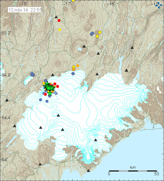
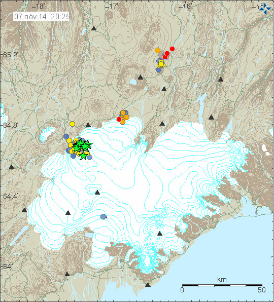
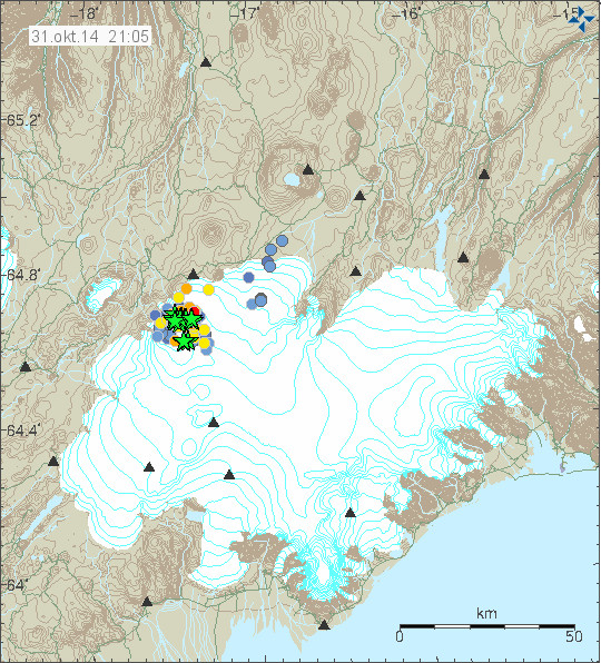
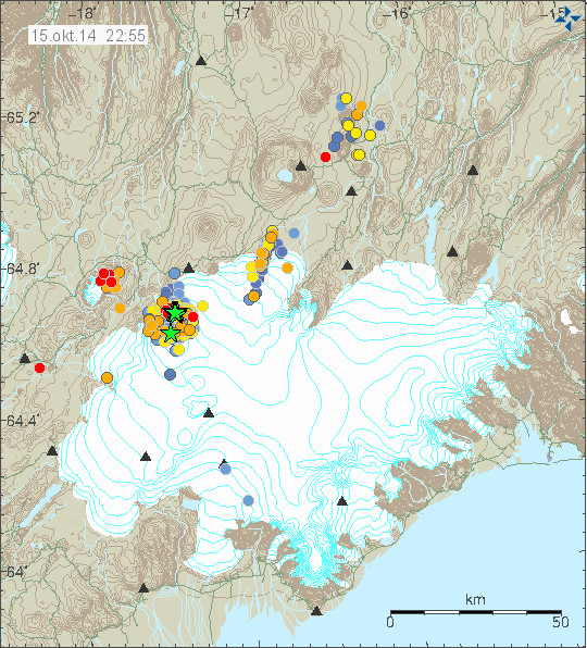
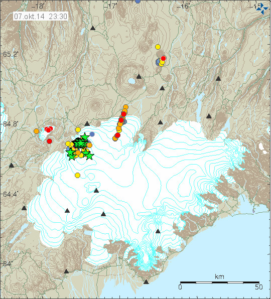
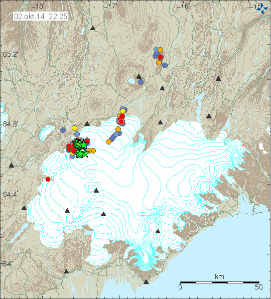
Earthquake activity has been in high today, compared to yesterday (19-October-2014). Strongest earthquake had the magnitude of 5,0 and the second largest earthquake had the magnitude of 4,8. Other earthquakes where smaller, but a lot of magnitude 3,0 and 4,0 have happened today. Earthquake activity along the dyke has been increasing again after few quiet days.

141021_0005
Earthquake activity today in Bárðarbunga volcano. Copyright of this image belongs to Icelandic Met Office.

The lava field in Holuhraun continues to grow and is now around 61 square kilometres in size. That is an (my own estimate) around 0,9 km² of lava in the Holuhraun area. Making this the largest eruption in Iceland for the past 200 years and it just keeps going on. The 16-October-2014 marked two month anniversary of start of the activity in Bárðarbunga volcano, it is going to be two months since the eruption started on 29-August-2014. The first eruption in Bárðarbunga volcano happened on 23-August-2014 and happened under the glacier, that eruption ended the same day. Other then what I report here, I don’t think there is nothing else to report about the eruption in Bárðarbunga volcano.

Notes about Bárðarbunga volcano

Please note that there is no evidence of felsic or intermediate magma in Bárðarbunga volcano. It is all just Ultramafic magma that is now erupting. For more details on magma please click here (Wikipedia). The glacier inside the caldera is moving down with the caldera. There is no evidence of any eruption taking place inside the caldera so far. It might happen in the future (and the wait might not be long), so far it just has not happened yet. There is a chance of hydrothermal activity taking place in Bárðarbunga volcano due the magma warning up the crust, that is however only of the magma is shallow as 1 – 2 km deep in the crust.

FreeBSD server

The reason why I didn’t update last weekend and late today is that I was trying to move my server from FreeBSD to Gentoo Linux. That did not work. What my server does is few things. Among the thing that my server does is to count earthquakes in Iceland like this image shows.

teljari.21.10.2014
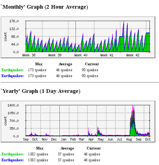
Image of the mrtg counter script for earthquakes. This image is released under Creative Commons, see CC Licence page for more details. Mrtg is a open source software.

It also runs my Minecraft server. I Play that game since I don’t play many games now. Both due to lack of time and interest. I play the game with my friends at times, when we have time to do so.

2014-10-21_00.16.26
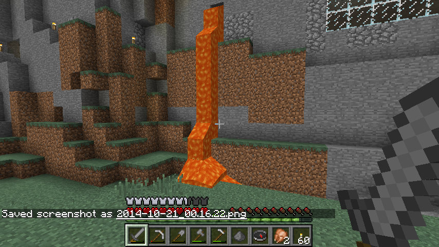
Lava in Minecraft. It doesn’t create lava fields. I guess that would be bad if it did that. Copyright of artwork belongs to Mojang and / or Microsoft. I took the image from the game using it screenshot function.

It is important for me to keep the earthquake counter running when I can do so. I also have to have my Minecraft server up and running so I can play when I have time to do so.

Article updated at 02:07 UTC.

Bárðarbunga volcano update for 15-October-2014

Far as I know there has not been a big change in the activity in Bárðarbunga volcano today (15-October-2014). Largest earthquake today had the magnitude of 5,4 and was felt in Akureyri. When the magnitude 5,4 earthquake happened the caldera dropped 15 cm in one go according to the GPS measurements in its centre. Over the past two days earthquake activity has been increasing in Bárðarbunga volcano and along the dyke that is erupting in Holuhraun. After the largest earthquake today the earthquake activity appears to have dropped a little.

141015_2255
The earthquake activity today in Bárðarbunga volcano. Copyright of this image belongs to Icelandic Met Office.

Other then this I don’t think there is anything more in news of activity in Bárðarbunga volcano. Since day to day activity remains the same. Tungafellsjökull volcano continues to show earthquake activity following the stress changes that are now taking place in Bárðarbunga volcano. I still think no eruption is going to take place in that volcano [Tungafellsjökull volcano], at least as things stand at the moment.

Those how are interested in hearing the magnitude 5,4 earthquake that happened today. It is possible to do so in this two audio files that I did convert from my earthquake data earlier. This is how my geophones at Böðvarshólar (bhrz) and Heklubyggð (hkbz) “hear” the earthquake. Each audio file is only 2 seconds long. The sound from Heklubyggð is louder since the earthquake signal is stronger there. Both audio files are released under Creative Commons Licence. Please see CC Licence page for more details.

Böðvarshólar geophone
141015.111600.bhrzZ

Heklubyggð geophone
141015.111607.hkbzZ

Bárðarbunga volcano daily update for 8-October-2014

This is daily update for Bárðarbunga volcano for 8-October-2014. Please note that I am doing to do the updates a bit shorter when nothing special is happening.

Current status in Bárðarbunga volcano

  • Largest earthquake today had the magnitude of 5,2. This earthquake took place NNE part of the caldera where majority of the large earthquakes have been happening for the past weeks. This activity might be because a dyke is drilling its way trough the crust in that one spot. This is just an idea (based on the clues that I get from the earthquake activity) and is so far not yet proven in any form.
  • No major changes have been reported in the eruption in Holuhraun. The lava field is now larger then 52 square kilometres in size. The eruption is about the same size as it was when it started five weeks ago.
  • Bad weather is preventing proper observation of the eruption at times.
  • The highest crater called Baugur is now some 100 meters tall. The crater called Suðri is around 40 to 50 meters tall. Other craters in the eruption are smaller. Icelandic news with picture with the name of craters can be found here.
  • There has been almost no earthquake activity detected today under the dyke today.
  • No other news to report today that I know of.

I am going to post update here if anything new happens. Volcanoes are unpredictable forces of nature so anything can happen without warning when they erupt.

Bárðarbunga daily update for 7-October-2014

This is the daily update for Bárðarbunga volcano on 6-October-2014.

I’m sorry for this late update. I’ve been more busy today then I planned. I did manage to solve one network problem that I was having. The other network problem that I am having is out of my reach it seems (It’s a problem with the ISP network connection to my end I think).

Status of Bárðarbunga volcano on 7-October-2014

  • The largest earthquake today had the magnitude of 5,5. It took place at 10:22 UTC. Other earthquakes that happened today where smaller. It seems that around 5 – 20 earthquakes that are larger then magnitude 3,0 happen every day now in Bárðarbunga volcano. This has been going on now for almost two months.
  • The eruption in Holuhraun continues far as I know. I am not sure on how large the lava field is today. Visibility has been poor to none today due to weather in this area at the moment.
  • Tourists are continuing to trying to kill them self by getting close to the eruption site. The newest case involves a millionaire (or billionaire?) from Kazakhstan that landed close the lava field. They where lucky that wind did not change direction while they where there. The amount of SO2 close to the eruption has been recorded going up to 130.000 μg/m³. That is good enough to kill instantly and melt people lungs (read up on that can be found here).  News item on this stunt can be found here.
  • I suspect that activity in the south part of Bárðarbunga volcano system is about to start. When it is going to start full force is impossible to know for sure.
  • It is a question of Tungnafellsjökull volcano is getting unstable due the unrest in Bárðarbunga volcano. It appears to be in the same rift area, even if it is in a different volcano.
  • Skrokkalda volcano appears to be stable for now (No GVP profile). This is important since Tungafellsjökull volcano fissure swarm extents into it and it is next to Bárðarbunga volcano fissure swarm. This volcano has no information on-line about it, besides what I have written about it. It is an active volcano, but has been dormant for a long time. Some hydrothermal activity might happen in it on the surface.
  • I don’t know how the status is on Hamarinn volcano (Loki-Fögrufjöll). I am however assuming that volcano to be unstable. It last erupted in July-2011 with a minor eruption that lasted some 8 to 10 hours in total. Eruptions in Hamarinn volcano happens without warning and without any earthquake activity, at least not high amount of earthquake activity far as I can tell.

141007_2330
Activity today in Bárðarbunga volcano and the 45 km long dyke. Copyright of this image belongs to Icelandic Met Office.

hkbz.svd.23.46.utc.on.07.10.2014
This is how the earthquake did appear on my geophone in Heklubyggð. The website for my geophones can be found here. This image is released under Creative Commons Licence. Please see CC Licence for more details.

If anything more happens I am going to add information about it here.

Bárðarbunga volcano daily update 02-October-2014

This information is going to get outdated quickly if anything happens in Bárðarbunga volcano.

Current status in Bárðarbunga volcano at 23:03 UTC

  • The eruption in Holuhraun continues at the same rate as before. There are no signs of it slowing down. I don’t know if new craters have opened up, it doesn’t look like it at the moment.
  • Bad weather has prevented visibility check from the ground. There currently is storm in the area with limited visibility at the moment. Please check the wind map for more details.
  • Largest earthquakes so far today where two magnitude 4,8 earthquakes that took place at 00:36 UTC and 13:27 UTC. Second largest earthquake took place at 06:39 UTC and had the magnitude of 4,6. Other earthquakes are smaller.
  • It seems that earthquake activity is increasing in Bárðarbunga volcano. I don’t think that is a good sign. So far there are no signs of an eruption under the glacier, at least not a large one at the moment.
  • Magma continues to flow into the dyke at the same rate as before. It also appears that the pressure inside the dyke is increasing since the eruption in Holuhraun is not keeping up with the material that is flowing into it.
  • Due to bad weather I don’t have any more information on the eruption in Holuhraun.
  • Bad weather is expected tomorrow in north Iceland and in the higher parts of Iceland at the same time. Snow is expected to fall in mountains and higher areas. This is going to mean poor or no visibility on Míla web cameras during this bad weather.

Information from GPS data

GPS data shows that the dyke that feeds the eruption in Holuhraun eruption is being well fed. There are no signs of any contraction taking place and it is clearly not cooling down. Earthquakes happen in the dyke when it expands since the eruption is not big enough. I don’t know why eruption has not yet broken up in a new place yet. As the times goes on the rock around the dyke gets soft from the heat, it turns into rubber type of mush that no longer breaks. This also applies to the crust above it. The depth down to the dyke is no more than 2 km, but it is expected that it is around 1 km or shallower in some areas.

141002_2225
The earthquake activity in Bárðarbunga volcano today and for the last 48 hours. This is just the earthquakes that have been recorded today trough the bad weather that has been taking place. So I am expecting more earthquake to have taken place than are showing up here. Copyright of this image belongs to Icelandic Met Office.

When the earthquake data is connected to GPS data it tells the story of an dyke that is being well fed and is trying to expand into nearby crust. Creating minor earthquake activity in the process. It is erupting so it can only expand by the volume that the eruption is not erupting. I don’t know how much that is, the dyke it self is around 3 – 4 meters wide and around 10 – 15 km deep (best estimate).

DYNC_3mrap.svd.02.10.2014.at.21.39.utc
The dyke size and feeding appears clearly here. I don’t know why it is moving west now, rather than east. This might suggest that something else is going on that does not appear on the surface yet (it might never appear on the surface). Copyright of this image belongs to University of Iceland.

URHC_3mrap.svd.02.10.at.21.39.utc
It is almost the same story on this GPS station. With the exception it is not moving to the west. It is stable where it is. This GPS station is almost on top of the dyke. So any change is going to appear quickly on it. Copyright of this image belongs to University of Iceland.

More GPS stations and information can be found here on University of Iceland website.

Break from Friday

I am going to go on a little break during this weekend from Friday. This means the following.

  • Comments are going to stay a little longer in moderation queue if you are commenting for the first time, or posting many links. If your comment vanishes it means the spam filter ate it, so it is going to take me a little time to recover it. So just wait a little for it.
  • If anything happens I might not be able to update this website with newest information right away. I will try to do soon as possible if I can.
  • Update for the Friday (03-October-2014) might be short and come in late (or not at all). When I don’t know yet.

This has been a busy one and half month for me. I’ve been watching Bárðarbunga volcano for almost all hours of the day regardless where I am and what I am doing. After a while it starts to tire you. That is why Icelandic Met Office and University of Iceland have people on rotation during this eruption. I don’t have that option so I just have to take a short breaks and hope nothing big happens while I am resting my self for a short while.

I did learn during the Eyjafjallajökull eruption in 2010 that if I spend too much time in this I burn out and the recovery from that is long process. That is why I now have plan to prevent that during a long eruption, that covers eruptions that are longer than one month. Like is now the case in Bárðarbunga volcano.

I advice this for anyone how is going to watch this eruption for a long period of time (since it is going to last a long period of time). Spending too much time on an eruption is not good. Even a one day break is a good thing for anyone watching this eruption.

In the case there is no new article tomorrow. I wish everyone a good weekend.

Article updated at 23:42 UTC

Article updated at 23:43 UTC

Bárðarbunga volcano daily update 30-September-2014

This information is going to change quickly if anything happens in Bárðarbunga volcano.

Current status in Bárðarbunga volcano at 21:49 UTC

  • There is no signs of the eruption in Holuhraun is about to end. Currently there are only one or two craters erupting.
  • The lava field is now around 47 square kilometre wide. It grows in wideness at the moment, it is not getting any longer since the magma has not the energy to go any future than it already has.
  • Earthquake activity continues to happen under the dyke and the eruption crater. So there is clearly high pressure in the dyke and not it is possible that the eruption that is now taking place is not large enough for the all the magma that is down in the dyke.
  • Largest earthquake today had the magnitude of 4,8 and took place at 19:24 UTC. Second largest earthquake took place at 14:53 UTC and had the magnitude of 4,7.
  • The lava that has now erupted in Holuhraun is two times larger than all of lava erupted in Kröflueldar eruptions that took place between 1974 – 1984.
  • Bárðarbunga volcano caldera has now dropped some 30 meters according to Magnus Tumi Guðmundsson geologists at University of Iceland. There is a plan to fly over Bárðarbunga volcano by end of this week, when maintain of the air plain that is being used for this is done.
  • Icelandic Met Office has confirmed that it is just lava flowing into Jökulsá á Fjöllum glacier river. This is not a new fissure at that location this time around.
  • Rifting in Bárðarbunga volcano area is about what Iceland moves in about 150 year period. This is happening all at once and it does not appear to be over.
  • Bad weather has prevented scientists  from being in the area most of the week. The weather is not expect to improve until 2-October-2014, since new storm is expected tomorrow.

One month ago at Holuhraun

This is the news one month ago (almost to the day) about what is happening back then.

An eruption possible in Holuhraun lava (28-August-2014. Rúv.is)
Fissure eruption in Holuhraun lava field (29-August-2014. Rúv.is)
Holuhraun eruption lasted 3-4 hours (29-August-2014. Rúv.is)

Tomorrow (1-October-2014) it is exactly one month since this happened.

Fresh eruption north of Bardarbunga -video (31-August-2014. Rúv.is)
Fresh eruption: 60 m high lava fountains (31-August-2014. Rúv.is)

How strong wind affects earthquake recoding

Here is a image from my geophone of how strong wind in north Atlantic ocean and Greenland sea affects my geophone recording and other seismometers in Iceland.

140930.210500.bhre.psn

Here is how you read this image. First is the earthquake, the P wave is first, second is S wave, along with other wave forms that happen in earthquake. The wave patterns that is all over this earthquake recording is ocean wave from winds. Both the ocean waves that happen at the coast, but also the ocean waves at deep ocean far from Iceland coast line. The spike at 21:07:21 – 21:07:41 is a electric noise. The noise at 21:08:41 – 21:09:21 is an animal or some other type of noise source. This image is released under Creative Commons Licence. Please see CC Licence page for more details.

Article updated at 21:51 UTC.