
This information is going to change quickly if anything happens in Bárðarbunga volcano.
Current status in Bárðarbunga volcano at 21:49 UTC
- There is no signs of the eruption in Holuhraun is about to end. Currently there are only one or two craters erupting.
- The lava field is now around 47 square kilometre wide. It grows in wideness at the moment, it is not getting any longer since the magma has not the energy to go any future than it already has.
- Earthquake activity continues to happen under the dyke and the eruption crater. So there is clearly high pressure in the dyke and not it is possible that the eruption that is now taking place is not large enough for the all the magma that is down in the dyke.
- Largest earthquake today had the magnitude of 4,8 and took place at 19:24 UTC. Second largest earthquake took place at 14:53 UTC and had the magnitude of 4,7.
- The lava that has now erupted in Holuhraun is two times larger than all of lava erupted in Kröflueldar eruptions that took place between 1974 – 1984.
- Bárðarbunga volcano caldera has now dropped some 30 meters according to Magnus Tumi Guðmundsson geologists at University of Iceland. There is a plan to fly over Bárðarbunga volcano by end of this week, when maintain of the air plain that is being used for this is done.
- Icelandic Met Office has confirmed that it is just lava flowing into Jökulsá á Fjöllum glacier river. This is not a new fissure at that location this time around.
- Rifting in Bárðarbunga volcano area is about what Iceland moves in about 150 year period. This is happening all at once and it does not appear to be over.
- Bad weather has prevented scientists from being in the area most of the week. The weather is not expect to improve until 2-October-2014, since new storm is expected tomorrow.
One month ago at Holuhraun
This is the news one month ago (almost to the day) about what is happening back then.
An eruption possible in Holuhraun lava (28-August-2014. Rúv.is)
Fissure eruption in Holuhraun lava field (29-August-2014. Rúv.is)
Holuhraun eruption lasted 3-4 hours (29-August-2014. Rúv.is)
Tomorrow (1-October-2014) it is exactly one month since this happened.
Fresh eruption north of Bardarbunga -video (31-August-2014. Rúv.is)
Fresh eruption: 60 m high lava fountains (31-August-2014. Rúv.is)
How strong wind affects earthquake recoding
Here is a image from my geophone of how strong wind in north Atlantic ocean and Greenland sea affects my geophone recording and other seismometers in Iceland.
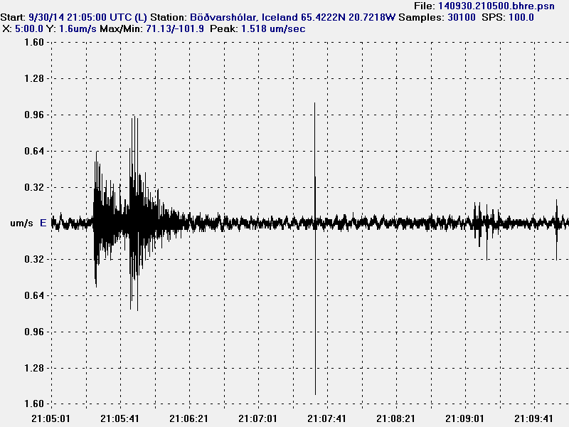
Here is how you read this image. First is the earthquake, the P wave is first, second is S wave, along with other wave forms that happen in earthquake. The wave patterns that is all over this earthquake recording is ocean wave from winds. Both the ocean waves that happen at the coast, but also the ocean waves at deep ocean far from Iceland coast line. The spike at 21:07:21 – 21:07:41 is a electric noise. The noise at 21:08:41 – 21:09:21 is an animal or some other type of noise source. This image is released under Creative Commons Licence. Please see CC Licence page for more details.
Article updated at 21:51 UTC.
Thanks for the update Jon!
It is interesting to read about the increased rifting that is occuring that normally takes much longer to happen. Makes you wonder what else to continental plates are doing around the world, if there is that much movement.
*two*
This is how rifting happens most of the time. The average number is not correct in such way that this doesn’t happen in such way that the crust moves 2cm/year. It moves meters at the time once rifting starts and rifting this way can last for years at the time. With long quiet periods between them.
Thanks Jón!
It seems the scientists are having some fun with the viewers right now… Flashing lights… woot!
I’m hoping we can presume it’s not some kind of last ditch emergency signal, as if the cams have connectivity, so too certainly must the scientists.
One has to wonder if they’re blinking those headlights at the cams on purpose. Global volcano rave!
No, this the international emergency code indicating SO2 distress.
Poor fellows.
The cloud did come there way a few minutes ago and it looks pretty murky now. Blinking’s stopped now anyhow.
“their” not “there”
Maybe a quake set off the car alarm. Or they’re being robbed by trolls!
they are leaving now
Thanks so much Jon! You are doing a fantastic job! I do have a question for anyone looking at cam#1 at the moment. What are those 2 lights that are blinking next to R2D2? Is that a scientist’s car’s headlights?
Looking very smokey or foggy right now. Okay I see it is a car now and their is more light. Dark clouds are floating about also.
This makes sense. However, does it affect other areas around the plate, not directly in the rifting area, such as the north American plate have troubles in say, Oklahoma?
We could only wish.
Thanks for the update Jon and the explanation on reading the charts. Clears up what wind looks like.
Could this rifting episode cause a mantel decompression and generate magma enough to cause a big eruption in the dyke, with magma that comes directly from the mantle and not from Bardarbunga?
No. It would no do that.
Don’t understand why a spreading rift doesn’t ‘encourage’ decompression melting, if only by reducing compressional forces. At the very least, it seems to encourage dyke propagation along fault lines of low compression.
Moreover, rifting suggests gaps which create voids. Subsidence and graben formation are prominent features. Must it always be due to magma draining away?
I hope this USGS link answers your question. Rifting does encourage dykes to fill up the void that rifting creates. Since nature does not like empty spaces on Earth. The dykes come from central volcanoes, they just don’t come from the mantle.
http://pubs.usgs.gov/gip/dynamic/understanding.html
Yes. … Someone wrote that dykes propagate along lines of minimal compression. The rock most easily cleaves in that direction. The dyke is describing a flank eruption where magma is pushing out horizontally from the central conduit to eventually perhaps broach the flank of the volcanic edifice, should such be encountered.
Upwelling magma and dykes (at least 2 of them) propagating from radial fractures at Barðarbunga are separate events contributing to the whole picture
You have to address the question why magma is erupting at all. Scientist like McGarvie (the link to the article was given by IngaB some time ago) say that it is caused by dissolved gasses in the magma which form small ‘bubbles’ due to decompression or cooling of the magma. He also said that some scientists disagree or may disagree so there is no consensus on this.
“The same thing happens when you open a bottle of soda, particularly after shaking it up. When you decompress the soda (by opening the bottle), the tiny gas bubbles push out and escape. If you shake the bottle up first, the bubbles are all mixed up in the soda so they push a lot of the soda out with them”
http://science.howstuffworks.com/nature/natural-disasters/volcano3.htm
Thew word soda pops up again, no coincidence that it is translated into ‘gos’ which also means eruption in Icelandic.
http://icelandgeology.net/?p=5066&cpage=3#comment-62335
I have to correct myself, there is a consensus on the cause(s) of magma to erupt.
The ongoing debate among scientist was on the following:
Final thoughts 2 – the oddness of subglacial calderas?
“I have also revealed via a few tweets and in the above that I consider an important mechanism in the evolution of subglacial calderas in Iceland to be due to a combination of ‘normal’ flexing of the caldera floor in response to subsidence plus upwards growth of caldera rim zones from the icy confinement of effusive eruptives. Other scientists may disagree. That’s not to say that Icelandic calderas cannot also form via major explosive eruptions as happens elsewhere in the world. I am merely pointing out that there’s something special about subglacial calderas that can make them seem much more impressive in their vertical extent without them being formed solely during a single major explosive eruption. After all, there is as yet no evidence that has convinced me that the formation of any major Icelandic caldera is linked to a single cataclysmic eruption…. “
Thanks Jon. That helped a fair bit. Writing my understanding briefly …
Barðarbunga (or nearby) is a triple junction. Magma upwells at the triple junctions because divergent plates are being pulled apart in 3 directions, rather than just 2 directions as would be so with divergent plates.
Think of it as a ring fracture pattern caused by stone hitting glass and making a hole. The triple diverging plates makes for a rapidly widening hole. The tension applied to 3 sides of the hole simultaneously is sufficient to contribute to decompression melting effect.
Bárðarbunga is not on a trip-junction. Far from it. This is a simple rift zone with central volcanoes.
More on this.
http://en.wikipedia.org/wiki/Triple_junction
I will be pushing the limits of definition of a tripple junction. While in Iceland, only 2 tectonic plates meet, there is Hreppar microplate.
In Bardarbunga you can find 3 boundaries meeting:
1) rifting zone between European plate and North American (north of Bardarbunga, along Askja region, where eruption s taking place)
2) rifting zone between European plate and Hreppar microplate (south of Bardarbunga, along Hamarinn and Veidivotn region)
3) boundary between Hreppar and North American, along Langjokull-Hofsjokull-Tungnafellsjokull, a sort of transform zone, but rather inactive in past centuries.
More clear tripple junction is at Hengill, where rifting north and south of it, meets the transform zone of SISZ (from Hreppar microplate)
I am not speaking of Hekla-Torfajokull region, but in the future as rifting spreads southwards and SISZ maintains its transform zone, then it would become also a sort of tripple juntion.
Interesting article by Páll Einarsson discribing the tectonic environment in Iceland:
Plate boundaries, rifts and transforms in Iceland (2008)
http://jardvis.hi.is/sites/jardvis.hi.is/files/Pdf_skjol/Jokull58_pdf/jokull58-einarsson.pdf
And in this document, p.3, you have a map with the hreppar plate indicated.
http://www.ife.uni-hannover.de/fileadmin/institut/pdf/pdf_seeberAbschied/eina5.pdf
Microplates btw. are also tectonic plates.
Sorry, my English, ehm … meant: describing.
Indeed, I was at a public lecture today by Pall Einarsson and he stated there that Bardarbunga lies on a triple junction between the North American, Eurasian and hreppa microplate.
Just saw a car drive up on camera 1.
The river is the low point in this gently down-sloping plain. Like water, it’ll run where there is least resistance. Basically it’s down the river we go now.
Must be time for a new river.
And a new map next year.
Yeah I’ve been wondering how google maps will handle it. … so far looks like the old map. And can they do street view in an SO2 soup? The cars are robots after all.
Try maps.yahoo.com on satellite mode. I doubt it is real time but you can see the lava field spreading.
Looks like there have been some >3 quakes a bit away from the main caldera. Maybe this is the beginning of the development of a new nested caldera. I guess enough magma has moved to allow for the natural progression to happen as the weight from above starts to collapse into the weakened area of the magma pool. It appears most of the central volcanoes contain some variant of nested caldera/ multiple calderas.
That’s certainly a possible scenario. It’s what’s happening now at Kilauea / Halemaumau / the Overlook vent in Hawaii (over time). This photo shows Halemaumau with the Overlook vent nested asymmetrically inside it.
http://hvo.wr.usgs.gov/multimedia/uploads/multimediaFile-800.jpg
Fortunately the lava flow from Pu’u O that has been menacing the town of Pahoa has stalled for the moment due to a breakout from the tube farther uprift.
That is an awesome photo of that. It is so cool to think about that light crust sitting on top of all that gooey hot lava just below.
Can see lightning flashes in the distance on cam 1. Stormy weather on the south side of the island.
Good morning and God bless everyone.
Just saw a vehicle seemingly towing away something (Mila webcam 2).
I think the “R2D2” Doppler radar got towed away
I think it was the little until sitting next to the bigger one that got towed away. It looked like the larger until was still there although hard to tell once the headlights left the area.
Morning all. well it is early in the morning and I might be mistaken but it looks like that R2D2 has gone on holiday. They might have moved him, as if they left it any longer access to the area could be restricted by the lava field, He might be hiding there but I find it hard to see him in this low light.
While reading about Bardarbunga earthquakes, I ran across this very interesting paper, and would like to share it with the community. Please see http://rses.anu.edu.au/~hrvoje/Bardarbunga.html . No one yet can explain why no volumetric change was seen which is surprising.
I keep wondering about why the current magnitude 5 quakes keep occurring and what could be their source, it would appear that a slow caldera collapse is causing them, but the exact mechanism is still unknown. Has anyone been looking at the motion mechanisms for these quakes (commonly known as earthquake balls) to get some idea on this as to what is actually happening?
One more item, an incredible very recent video showing the awesome size of this eruption:
https://www.youtube.com/watch?v=RcoZXxhRbIk&list=UUR8I9qKINWwIMQX5ZMwgprA&feature=player_detailpage
Or search for Jan Egholm title “Volcano at Holuhraun close to Bárðarbunga Iceland”
….and why they dont made some picts from the subsidance ? … damn tourists …
Interesting video. The erupting fissure appears to be around 800 meters long and no signs of it closing down any time soon.
Yes, the beachballs confirm subsidence. White centers.
Another paper from 2010 re. the 1996 quake indicating caldera drop:
http://www.geo.uu.nl/~seismain/pdf/2010_Bardarbunga_EPSL.pdf
The beachballs of the 5+ quakes are to be found at:
http://geofon.gfz-potsdam.de/eqinfo/list.php
Is that a drone on Mila cam2? I’ve seen it quite a few times over the last couple of weeks always over to the left.
It really seems like the EQs are dying down.
Breaking News:
The Bardabunga-Projektmanagent-Team told me, they reched the first milestone: A lava field greater than 50 km³. Next milestone: glacier flood – they are working on it ….
Mike, do you have a link to the above article?
Actually, they are still working on the 50 km2, but there is no long way to go any more: http://www.ruv.is/frett/hraunid-ordid-482-ferkilometrar
Wow Randell a great video , super stuff
Bit of a blizzard on Mila 1 at the moment
Don´t believe everything Google translate tells you.
http://snag.gy/EuSH7.jpg
gos = 1) eruption, 2) limonade
hraun = 1) lava, 2) special sort of biscuits
🙂
A lot of action tonight … some pics here
http://www.brisske.de/Fotos/Public/index.php?AlbumDir=/Fotos/Public/2014-10-01_Bardarbunga
Really bad smelling fog in Western France this morning, pollution from volcano?
strong smell of eggs/burnt matches? or just my over active imagination?
Another record measurement. In the area around Myvatn the levels of SO2 measured around 5.800 mcgr/m3 last night and until morning.
Satellite pictures of the SO2 over Europe (DLR):
http://atmos.eoc.dlr.de/gome2/images/Bardarbunga_2014.gif
Insane levels of SO2, those levels.
Those probably felt like breathing from a car exhaust. And with terrible low smog visibility.
One can see that during this eruption, there were 3 major burst releases of SO2: the start of the eruption, then between the 4th and 9th of September, and in 19th September. After that, the SO2 release is lower. Or probably it’s just more windy.
Well possible that there was Bardarbunga “parfum” in western France.
This is from 25th:
http://www.meteo-paris.com/actualites/pollution-en-france-et-benelux-volcans-bardarbunga-et-holuhraun-en-islande-25-septembre-2014.html
Although the magnitude 5+ EQ’s have lulled, the pattern for Mag 3+ to the NE flank and Southern flank of Bardarbunga from 10km to 5km has intensified over last 24 hours.
Univ. of Iceland @uni_iceland · 34 min Há 34 minutos
Quick back of envelope calc: 48.2 x 14m (apprx. avg. thickn) = 0.67 km3 volume / 32 days = 242 m3/s avg. effusion rate (~3.7x river Thames)
Univ. of Iceland @uni_iceland · 44 min Há 44 minutos
New #Holuhraun lava field was ~48.2 km2 yesterday. No signs of any decrease in activity. #Bardarbunga still shaking
Great light at the moment Mila Cam 1 the air is very clear and should get better and cooler as the low pressure system passes to the east and draws down some true arctic air, possibly more snow as well by Friday, remaining stormy from that deep low though.
Bad weather coming from the south … will probably soon terminate the cam-show for a while
The lava field measures 47.8 km2. New map here.
http://www.visir.is/hraunid-47,8-ferkilometrar/article/2014141009884
IngeB regarding the SO2 readings from first month of eruption there is no doubt that the East of Island has been in the firing range for large periods of the time and also with the highest levels.
I know AutumnWinter the Atlanic fires up and so if the eruption continues as it is, wind strength and direction will help protect those living in the East from sustained SO2 influx.
Long range weather models are indicating High pressure anomalies for Greenland through Island regions.
This if it proves correct it will deflect the Atlantic winds and with cold dense air cause serious breathing issues as it holds air circulation in place.
As the fissure eruption has shown over its first month, it has maintained an equilibrium in height.
At present it shows no sign of abating. I feel with the possibly of any locked in High pressure system. I feel now would be a time to start thinking ahead for Easterners with children and elderly folk in mind to stock up on bottled water, foods, and fuel. If we are still in the same position in two months with the fissure eruption then further actions would need to be taken I.e sealing homes.
I’m not saying this to scaremonger or to frighten anyone but out of concern for the people’s healthIngeB regarding the SO2 readings from first month of eruption there is no doubt that the East of Island has been in the firing range for large periods of the time and also with the highest levels.
I know AutumnWinter the Atlanic fires up and so if the eruption continues as it is, wind strength and direction will help protect those living in the East from sustained SO2 influx.
Long range weather models are indicating High pressure anomalies for Greenland through Island regions.
This if it proves correct it will deflect the Atlantic winds and with cold dense air cause serious breathing issues as it holds air circulation in place.
As the fissure eruption has shown over its first month, it has maintained an equilibrium in height.
At present it shows no sign of abating. I feel with the possibly of any locked in High pressure system. I feel now would be a time to start thinking ahead for Easterners with children and elderly folk in mind to stock up on bottled water, foods, and fuel. If we are still in the same position in two months with the fissure eruption then further actions would need to be taken I.e sealing homes.
I’m not saying this to scaremonger or frighten anyone, but out of concern for the people’s health.
There’s a saying” Better to have something close at hand than have to go looking for it.”
.
There’s a saying” Better to have something close at hand than have to go looking for it.”
I really hope that this extremely high gas emission does stop now anytime soon. I am thinking a lot about these poor people under these clouds!
0.67 km3 in Holuhraun.
That’s a big value. It’s almost getting to the size of Hekla 1947, which was the largest lava eruption in Iceland since Laki.
In a little bit more than 2 weeks, this eruption will reach 1km3 and so it will be second greatest eruption (magma erupted, lava and ash) since Laki, just after Askja 1875.
Well, it is showing to be not just another lava eruption, but one of those historical lava flood events. If this is true, then it will probably get well past 1km3 and form a new shield volcano in the region.
This is an exciting historical event!
It is regrettably not really exciting for the people who have breathing difficulties, children, older people and others whose health should be a concern.
What do the assembled experts think:
In one of the above cited papers it was described how seismic tomography was conducted by inverting a signal from measurements at 11 stations.
This seems like very few points to operate on.
How shall one have much confidence in the results?
If these seismic stations are recording quakes/sources from many azimuths and distances, the tomography is actually sampling a lot more of the immediate area/volume than you might think ….
On Jon’s Webicorders, why is the second plot (Hekla) nearly black.
Jón notices, that it is a “Noisy geophone station”. Wind, traffic, electricity etc. Last 2-3 days there was a windy weather in the Iceland.
There is a storm in south Iceland at the moment.
wind most likely. 15 m/s average right now like the page linked directly below the plot indicates.
Thanks Jon must be a big storm for that much noise.
Yes, average wind speeds over 20 m/sec. are a lot.
http://www.vegagerdin.is/ferdaupplysingar/faerd-og-vedur/sudurland/linurit/st198.html
(from the station next to Hekla)
that’s 44.7387 mph for those who don’t have a feel for metric.
Today the riverfront must surely be much increased in width.
The frightful glowing bulk must be much bigger now.
This should become a good show!
Any comment on the pattern today of more frequent quakes in the 3 to 4 range?
Maybe a trend towards smaller quakes,indicates a state of higher temperature in the magma chamber?
I have been watching this site for a bit and am grateful for all the info and links. I have learned so much. Jon you do an amazing job. Here are two videos I came across today. It is video of the eruption taken from a drone. I do not know how to post them so you just have to click to access the video. Sorry, but they are worth the copy and paste to see them.
http://www.youtube.com/watch?v=8cICS9MtRRw
http://www.youtube.com/watch?v=_L6Phuwqi7Y
Great videos – Thanks for sharing the links.
Volcano maneuvers in the dark…
Btw.: We had a mag. 4,8 2 hours ago and, exactly like yesterday a sharp drop in GPS-signal with the blue line meanwhile climbing again… looks virtually identical.
The gps on top of BB caldera when it was set up on the 11th.
http://snag.gy/q2UqH.jpg
I am so glad I discovered this site about a month ago. I am not a scientist, just a person interested in the strength of Mother Nature. I have learned so much from all of the post and links. Thank you, Jon, for being willing to host such a site. You do an amazing job. I did come across two videos today and knew I had to post them. They were filmed over the Holuhraun eruption using a drone. I do not know if I just paste the links here if it will work. But if it doesn’t it is well worth the copy paste.
http://www.youtube.com/watch?v=8cICS9MtRRw
http://www.youtube.com/watch?v=_L6Phuwqi7Y
Thanks again for everyone who has contributed to make this a great and informative site.
Sorry for posting twice. Didn’t think the first one worked.
Your first post had been eaten by the spam filter. I did rescue it from it and approved it.
Great videos!
I haven’t seen this link posted here before:
A couple of drone videos shot at Holuhraun lava field and the article says they got so close it melted the front of the GoPro camera.
http://www.wired.com/2014/10/drone-video-iceland-eruption-bardarbunga-volcano/
Another video, this time shot from a drone, which is probably the ideal aircraft to do this kind of stuff. See http://www.youtube.com/watch?v=8cICS9MtRRw.
Just as I was posting, brucels beat me to it.
Just testing my maths and eyesight…
(It’s quiet tonight on the blog ?)
🙂
New article is up about current status in Bárðarbunga volcano.