
Far as I know there has not been a big change in the activity in Bárðarbunga volcano today (15-October-2014). Largest earthquake today had the magnitude of 5,4 and was felt in Akureyri. When the magnitude 5,4 earthquake happened the caldera dropped 15 cm in one go according to the GPS measurements in its centre. Over the past two days earthquake activity has been increasing in Bárðarbunga volcano and along the dyke that is erupting in Holuhraun. After the largest earthquake today the earthquake activity appears to have dropped a little.
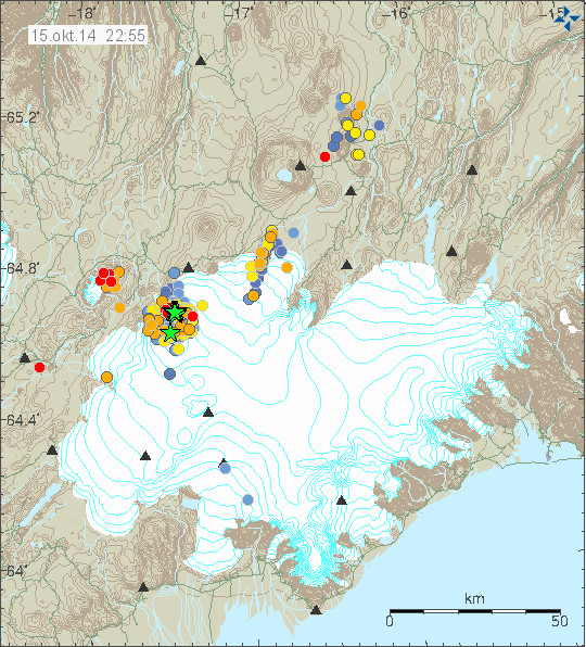
The earthquake activity today in Bárðarbunga volcano. Copyright of this image belongs to Icelandic Met Office.
Other then this I don’t think there is anything more in news of activity in Bárðarbunga volcano. Since day to day activity remains the same. Tungafellsjökull volcano continues to show earthquake activity following the stress changes that are now taking place in Bárðarbunga volcano. I still think no eruption is going to take place in that volcano [Tungafellsjökull volcano], at least as things stand at the moment.
Those how are interested in hearing the magnitude 5,4 earthquake that happened today. It is possible to do so in this two audio files that I did convert from my earthquake data earlier. This is how my geophones at Böðvarshólar (bhrz) and Heklubyggð (hkbz) “hear” the earthquake. Each audio file is only 2 seconds long. The sound from Heklubyggð is louder since the earthquake signal is stronger there. Both audio files are released under Creative Commons Licence. Please see CC Licence page for more details.
Böðvarshólar geophone
141015.111600.bhrzZ
Heklubyggð geophone
141015.111607.hkbzZ
WOW, JON,
Interesting sound.
Is that a common frequency range?
I found myself wondering . . . if some clever bloke had ever or could jiggle together a wide range of such quake sounds into a “song” like some folks have done with animal sounds. LOL.
Are your geophones on the surface of the soil?
http://earthquake.usgs.gov/earthquakes/map/#%7B%22feed%22%3A%221day_m25%22%2C%22search%22%3Anull%2C%22sort%22%3A%22newest%22%2C%22basemap%22%3A%22grayscale%22%2C%22autoUpdate%22%3Atrue%2C%22restrictListToMap%22%3Atrue%2C%22timeZone%22%3A%22local%22%2C%22mapposition%22%3A%5B%5B-60.93043220292333%2C-279.140625%5D%2C%5B83.31873282163234%2C79.1015625%5D%5D%2C%22overlays%22%3A%7B%22plates%22%3Atrue%7D%2C%22viewModes%22%3A%7B%22list%22%3Atrue%2C%22map%22%3Atrue%2C%22settings%22%3Afalse%2C%22help%22%3Afalse%7D%7D
The song is updated constantly and the activity is now a chorus.
Jon, Thank you for the audio of the 5.4 EQ at Bardarbunga today. I just think the sound from your 2 stations was just so cool. I had to listen over and over to each recording. I was just fascinated that I could really hear to an EQ. Wow!
A golden oldie, re volcano sound. Mt Redoubt: http://www.washington.edu/news/2013/07/14/some-volcanoes-scream-at-ever-higher-pitches-until-they-blow-their-tops/
Remins me of the sound of the kettle whistle just before the water starts to boil. Guess we are talking about a similar effect.
THANKS WIAL.
Thank you for the sound clips, Jón. It was not the sound I expected, just as the crunching-paper-breaking-glass sound of the lava being pushed around at Holuhraun was not the sound I expected. Very interesting.
The ‘screaming’ pressure recorded when other volcanos erupted, however, was more or less what I expected.
Sounds like mother earths heartbeat! Thanks again Jon
Interesting sounds – thank you for sharing!
(Aerial- and ground-) Pictures of the eruption at Holuhraun / Bardarbunga (September 2014 – more pictures will follow soon …):
http://www.lukas-gawenda.de/bildergalerie/vulkanausbruch-island/
Please subscribe my newsletter to stay up to date (regarding new pictures):
http://www.lukas-gawenda.de/newsletter/
Kind regards
Lukas
Ok Jon, I mentioned this to you a couple of days ago when the blue frequency on Reykjanes got my attention between 1 and 2 (below), now we have a step up on all bands. I know activity on all event area sil’s is getting quite intense again, but I am keep a weather eye on Reykjanes –
http://snag.gy/4ZHOb.jpg
There is a polar cyclone south of Iceland. It is getting closer and is going to start a storm in Iceland tomorrow I think.
Scots John, Jon, et al
Has there been on record . . . any such increase in critical frequencies . . .
WITHOUT a reasonably soon following eruptive activity?
Da Xin, The activity I am talking about is not eruptive. It may be weather related or early signs of something else, but nothing of importance ok.
Some small things mean something, others mean little or nothing. I was just pointing it out to Jon and Irpsit as he commented the other day too.
Or, put another way . . .
What percentage of the time has there been such an increase in critical frequencies
WITHOUT
a reasonably soon following eruptive activity?
I just got myself a new message signal on the phone. An earthquake! Thanks!
As others have said, very interesting to “hear” the earthquake. Thanks for posting the audio files.
I put “hear” in scare quotes because, as I understand things, the actual frequencies are too low for humans to hear, so I am wondering what modifications are made to the signal to bring it within human hearing? Or perhaps I’ve misunderstood.
It is possible to hear bigger earthquakes resp. the breaking of rocks in this case, it was clearly to hear eg. in 2008, when I was out walking near Reykjavík and the aftershocks of the 6+ magn. in South Iceland struck there. Heard a low rumbling sound and at the same time the ground moved (was measured around magn. 4.5 in Reykjavík, as far as I remember).
Interesting, thanks. And thinking it through, I think I may have made a mistake in my first post: obviously, it’ll be possible to hear rocks crashing against each other if one’s near enough or one’s hearing is sensitive enough.
PS I remember camping in the near vicinity of the Krafla fires 36 hrs after an eruption had finished, and though we didn’t hear anything, I certainly felt a very slight bump in the night (!).
I have heard earthquakes. Sounded like a big truck rumbling up the alley behind the house.
another earthquake/volcano sound project from a german scientist
http://www.seismo.ethz.ch/static/100j/snapshot04/sn04_musik.html
WOW! That sound is amazing! Very interesting!
Interesting that activity in the dyke has slowed down so much today. Looks like it’s all moving towards the caldera and Tung volcano now.
Possibly through my own lack of understanding, but it often amuses me when I hear the term “it’s just tectonic” being used with regards to swarms happening in old volcanic systems in Iceland.
When a swarm happens in a volcanic system located within a volcanically active region of Iceland how can it simply just be dismissed as “tectonic”?? Especially when these swarms are reoccurring time & time again???
Tungnafellsjökull & Herðubreið are two volcanoes that stick out. Just because neither have erupted in the past 10,000 years or so, any activity in them is normally referred to as “tectonic”. In geological terms 10-15,000 years is nothing – a mere second or 2 in the earths life.
6,500 years ago there where fissure eruptions, and volcanic eruptions in the south of France… 8,500 years ago a near super eruption happened in the Rhine lands of Germany (ve7) – neither of these regions are considered extinct, and both are expected to erupt again in the future.
So why it so hard to except that swarms happening within long dormant volcanoes located in the heart of Iceland’s active volcanic region could be more then just “tectonic”?
As I understand “tectonic”, that´s exactly what´s causing the eruptions in the first place. The plates move apart, creating room for lava to enter the surface. So I agree Ian, people are used to certain things happening in the area, which normally won´t lead to anything. But this time may be different. Nobody really knows what´s happening underground. It´s all pure guesswork. So maybe it´s a good idea to keep an open mind while we watch this unfold.
However I find it very interesting to read about all these different theories and possible outcomes. So far nobody has been proven right or wrong. Guess we´ll just have to be patient.
Everything in Iceland is tectonic and magmatic at same time.
But processes can be different. Rifting is tectonic but then magma rises upwards to fill the void and eventually erupt.
In Icelandic transform zones, the movement is lateral slip-strike, so it’s tectonics, but magma still fills the void, and this results in rare and small eruptions every few millenia (ex. Grimsnes volcanic field).
Sometimes an intrusion at deep is clearly magmatic earthquakes, but this can increase tectonic strain, resulting in tectonic quakes in nearby regions.
Ultimtately it’s all tectonic and magmatic as I said, but different mechanisms. And all driven by magma at the core origin.
In Tungnafellsjokull we see some rifting occuring, those are tectonic quakes but they allow magma to rise upwards. Some months ago we saw some magmatic quakes there, deep ones. So I think its possible to see an eruption there.
Thanks Irpsit, your description sounds logical
There is one thing that has been going back and forth in my mind, I mean I get that those small shallow EQs are probably tectonic and the deeper small to mid EQs are magmatic, as we see in the dyke.
But what about the 4+ and 5+ IQs in BB? Most of them seem to come from the same tiny area around 4-5 km NE from the center of the caldera and from a depth of 1-10 km. What are they? Does anybody even know?
Also the deep earthquakes can be tectonic. The dyke is reaching down to a depth of around 15 km at least, and this is at the same time a rift (so volcanic and tectonic at the same time here).
Or if you think about the ill famed big Sumatra quake (see:http://earthquake.usgs.gov/earthquakes/eqinthenews/2004/us2004slav/#details and http://neic.usgs.gov/neis/eq_depot/2004/eq_041226/neic_slav_nr.html ) , it was very deep down at a depth of 30 km and tectonic due to the subduction in the region, the Indian Plate dives here under the Burma Plate.
So the depth of the hypocenter is not what makes quakes tectonic or volcanic, but the geologic context will decide about this.
The magn. 5+ quakes are on the rim of a big volcano and – as far as we know up to now – caused either by:
a) subsidence of the caldera (volcanic + tectonic) or
b) small rhyolitic eruptions on the caldera rim (volcanic) or
c) a high temperature system (geothermal system) situated on the caldera rim and heating up / so much as to break rocks? (would be both: volcanic and tectonic)
So as long as we don’t know what is really going on, we neither can’t decide about the nature of the earthquakes.
And as was rightly mentioned before, in Iceland, very often tectonics and volcanism are mixted up.
But this is though not always the case, eg. not in the SISZ (the South Icelandic Seismic Zone), a transform zone between the WVZ (Western Volcanic Zone, a volcanic and rift zone) and the EVZ (Eastern Volcanic Zone, also a volcanic and rift zone at the same time). This zone is, by means of earthquakes up to magn. 7, releasing strain which originates from plate movements incl. the aforementioned rift jump.
Yes, Inge, rightly said.
I want to add the fact that once I read on a paper that every major quake in SISZ does relate also to magma movements that try to fill the void, but it is very difficult for magma to intrude upwards in that context. However it does happen, nearly every fault in SISZ has some minor volcano on it. Ingolfsfjall, Grimsnes, Hestfjall, Vordufell, Skardsfjall…
A link or 2 re the Tungnafellsjökull volcano
http://www.volcano.si.edu/volcano.cfm?vn=373040
http://www.skimountaineer.com/ROF/Beyond/Tungna/TungnafellsjokullMap.jpg
from Nov 2013:
http://icelandgeology.net/?p=4096
http://www.touristlink.com/iceland/tungnafellsjokull/overview.html
http://goscandinavia.about.com/od/icelan1/a/icelandvolcanoes_2.htm
http://jardvis.hi.is/sites/jardvis.hi.is/files/Pdf_skjol/Bardarbunga_greinar/bjornsdottir_and_einarsson_2013.pdf
WARNING NOTE: searching for maps of that volcano can result in some shocking and lewd pages.
Neither shocking nor … :
http://atlas.lmi.is/kortasja/?x=585949.5482495164&y=466382.3982058594&l=2&anno=1&bm=2
and
http://atlas.lmi.is/kortasja_en/?x=562665.7353314705&y=495556.2611125223&l=2&anno=1&bm=3
(Landmaelingar Íslands) 🙂
Here in south Iceland, continues the damn Volcanic pollution. Yesterday the levels of SO2 were quite severe, up to 3300 ug/m3, which is twice as bad as the worst smog ever recorded in London or Beijing. When I went out, it was dirty air, very hazy, visibility less than 10km, a dirty smell like car exaust was notorious.
And it’s going to continue for a few more days. Yesterday apparently authorities send SMSs warning the population to stay indoors in certain parts of the country. Because levels were as such they would cause respiratory ill effects in everyone, not just the sensitive and eldery.
Widespread 1500 ug/m3 this dawn, and continued the thick haze and dirty air feeling, but now slighty better the air, some 200ug/m3, just polluted like a normal day on a large Chinese city 🙂 The haze still thick but not as thick as this morning.
And in the news, of course, they warn of upcoming acid rain, with the incoming precipitation this weekend. Surely I will cover my car with plastic this time. Dont want to see further corrosion happening.
It is good to be reminded of the discomfort and danger this eruption is causing to you all in Iceland. One of the things I am gaining from following this blog, from such generous, imaginative, intelligent contributors – thank you all so much! – is the sense of power of the earth, bigger, deeper, hotter, mightier than can be imagined and far far beyond our control. Fascinating, but serious business.
Does anyone have any educated guesses about what the “deep thudding” was that the IMO update refers to?
It seems they heard something. Their first guess was a landslide might have occured in Askja so they went to check but found nothing. So the current explanation is that it may have been from a jet flying over. Guess it´s difficult to tell.
IMO seems to think it sounded like rockfall and checked out Askja.Could it be sub glacial rim collapse?
Would be interesting to know where it was heard. In Reykjavík?
Dunno. They say they heard it about the same time as the 5.4 occurred.
Maybe rockslide at base of rim under thawing base of glacier?
Reykjavík would be about 300 km away from Bárdarbunga, but big aircraft crossing over there rather low most probable (landing/starting at the international airport at Keflavík). On the other hand, it would mean a different thing, if something going on in Bárdarbunga could be heard this far away.
Over Bárdarbunga, big aircraft would cross over at 10.000 m height and people working eg. at Holuhraun, most probably wouldn’t hear the aircraft.
No, they stated it was heard in the area.
Thank you Irpsit for the explanation 🙂
@IngeB 16:03
Thanks for the explanation.
I am not an expert and I have only recently started looking into these matters.
There are still some points that don´t add up in my (layman) mind.
You mention three possible causes to these larger quakes,
a) subsidence of the caldera (volcanic + tectonic) or
b) small rhyolitic eruptions on the caldera rim (volcanic) or
c) a high temperature system (geothermal system) situated on the caldera rim and heating up / so much as to break rocks? (would be both: volcanic and tectonic)
anyway, most of these quakes have origin around 3-7 km down in the ground. Only a few have been shallow, then again some have been as deep as 10 km.
To my knowledge the rim is around 1000-1500 meters above sea level, which is pretty far away from EQ origins. Even the most shallow large EQs are almost 2 km away from the rim.
So is it possible that the placement of the EQs right under the NE rim is coincidental and not related to the rim at all? I mean, if you look at the map it looks like the activity is on the rim, but if you look at it three dimensionally, it´s way below.
The scientists say it´s probably the magma chamber subsiding, which sounds more logical than surface activity causing deep 5+ EQs. At least the magma chamber(s) is down there in the same area.
Also the subsidence graph, it´s very lineal, with a slight curve, which means something big is causing it. Smaller incidents, like small eruptions melting ice, would make the line more erratic and surface heat would most likely cause the melting to speed up, not slow down. So I´d say this graph also fits the caldera collapse model.
Anyway, these are just my 50 cents. I don´t really know much about volcanoes, I´m just following my logic.
I was just enumerating possible causes which had been mentioned up to now.
With “rim” I just meant at the border of the mountain – also deep down within the roots of the volcano. Could perhaps magma be rupturing rock in seaking its way up to the surface there (b/c)?
I am no volcanologist either.
Rather interesting remarks by Icelandic volcanologist Ármann Höskuldsson in radio news today (RÁS 1, Hádegisfréttir, after 6:58 http://ruv.is/sarpurinn/hadegisfrettir/16102014-0).
He seems rather worried because of the subsidence of about 35 m now and suggests to think the context over again without excluding new perceptions (!): It could be that the behaviour of Bárdarbunga is not connected to the still ongoing eruption in Holuhraun. The last in itself seems rather unusual. But more unusual still is the trouble with the central volcano itself. So that there should be new studies done on the earthquakes troubling Bárdarbunga taking into consideration that they would have another origin as thought up to now, independent from what is going on at the dyke. Also in this light, Civil Protection plans should be reconsidered.
He is also worried about the gas situation, later on in the radio broadcast is mentioned that even in Reykjavík there were tops of over 3.000 µg/m³ last night (see also: http://testapi.rvk.is/#/stodchart/04/regular/41/10-15-2014/10-16-2014 ).
Yes time to dust off the other scenarios book.
The heating of the caldera chamber is causing the quakes,possibly the effect is magnified by the ice cap,think heat engine?If that is the case as the glacier thaws more energy can be released as heat through the surface,causing the larger quakes to reduce in number and glacial melt to accelerate?Just my thoughts.
“It could be that the behaviour of Bárdarbunga is not connected to the still ongoing eruption in Holuhraun.”
Just what I’ve been saying all along. Look at dfm’s models, there are two fissures of activity under bard, what missing? The eq’s that should be there if it was all moving down, not just two sides with the predominance.
This is complex and we are not looking at the area outside the immediate event in enough detail. NVZ and WVZ are going to move bringing in volcanoes in those areas as possibles.
https://www.youtube.com/user/dfmorvan/videos
The Holohraun lava is slightly evolved tholeiite, it has to come from a magma reservoir, probably from Bardarbunga. I think the most simple model is a flank eruption draining the reservoir and therefore the lowering of the Caldera. 35 m subsidence should fit to the ejected and intruded volume of the current event.
It was my understanding from the initial holuhraun sample analysis that it lacked MgO yet other elements were there that indicated it was evolved magma. However adiabatic melt of up to 30% from deep sourced magma (not from any of the reservoirs beneath Bard) would account for the elements that were present and account for the lack of MgO. The surface temperature was cited at 1150 degrees which would be in line with Uni calculations for decompression melting. I’m sure someone will correct me if I am wrong.
Isn’t it rather fair to conclude that the earthquakes aren’t caused by the subsidence since there are many large earthquakes without marked subsidence? Depending on where the earthquake hits in the caldera it would rather sometimes increase the subsidence. Since the earthquakes obviously happens mostly at depth I would guess they are caused by some process related to the volcanic chambers
My theory heating of a viscous magma(possibly rhyolite) chamber caused by large infusion of basalt due to a rifting event,this heating is more pronounced on the NE rim and there could be associated cryptodome development in that area causing heating and deformation(both subsidence and uplift) of that area of the caldera floor.
I think I have kind of the same idea. http://s47.photobucket.com/user/terjetyl/media/Bardarbunga_zpsa28a2a67.png.html
The rifting caused magma to rise, heating the crust and making the caldera floor gradually melt and sink. The volcanic plug idea seems off to me since all subsidise graphics indicate that the middle of the area is sinking the most and I cant see that this is consistent with the idea of a sinking plug
No evidence the caldera floor is sinking, that is just speculation.
test
@ tt22 “I cant see that this is consistent with the idea of a sinking plug”
unless… if we imagine that the heat source (intrusion) is smaller than the caldera floor and it´s heating mostly a smaller area and temperatures are lower in the surrounding areas, wouldn´t that indicate a cone like subsidence, the hottest area being melted a bit faster and therefore subsiding faster?
What about of a change in magmatic density?If the density of the magma chamber is changed could that not cause subsidence or block slippage into the lower density magma?
Some basic info material on magma (and also its density, p.2):
http://www.usu.edu/geo/shervais/G4500_PDF/45Week1B_Magmas.pdf
This article by Gudmundsson et al. is very informative, especially on the way that tectonic factors may have influenced what we observe in the caldera, in particular, the way in which the subsidence is off-set from its centre.
http://link.springer.com/article/10.1007%2Fs00445-014-0869-8
IngeB as you can see rhyolite has a low density than basalt and density changes with temperature so as the temperature rises the density lowers ,so that would explain the linear block slippage or subsidence,temperature related?
Would it not increase in volume and buoyancy and so rise instead?
” Increasing the temperature of a substance (with a few exceptions) decreases its density by increasing its volume. In most materials, heating the bottom of a fluid results in convection of the heat from the bottom to the top, due to the decrease in the density of the heated fluid. This causes it to rise relative to more dense unheated material.” ( https://en.wikipedia.org/wiki/Density )
I guess my idea was wrong,but I don’t know what part crustal pressure would play in the density/buoyancy aspect?
This ppt on magma ascent from University of Buffalo could be informative:
https://duckduckgo.com/l/?kh=-1&uddg=http%3A%2F%2Fwww.glyfac.buffalo.edu%2Fmib%2Fclass%2F306%2FPowerPoint%2F1A_MagmaAscent.ppt
Magnitude 4.3
Region ICELAND
Date time 2014-10-16 16:10:38.0 UTC
Location 64.49 N ; 17.97 W
Depth 10 km
http://m.emsc.eu/earthquake/earthquake.php?evid=404500
The focal mechanism of the EQs shows directionality of faults slipping. The big EQs are not caused by explosive events but slippage. This rules out b) and c). a) is consistent with the EQs the accumulator valve model and the volumes of lava produced outside and taken up by a widening rift.
Powerful earthquakes are particularly located in the north eastern Bardarbunga. What assumptions can we make it for all their depth is fairly uniform between 3 and 9 km.
It also seems to last for a few days in these same depths.
If the caldera collapses, we should see a rocking motion to the northeast but it does not seem to be this. If it’s magma seeking a way to the surface we should see the depth of these earthquakes decrease ; again, I can’t notice that…
Anyone have an idea? What may be happening ?
Is the main rifting process at the moment going a) right through the middle of the caldera (W-E) or is it more b) around it and over Vonarskard (S-N) or c) to the west of Tungnafellsjökull and then take a right turn (in eastern direction, before going north)?
I know that part of the ongoing rifting is taken up by Dyngjujökull and the intrusion (also the graben in the making, btw.), but are there other branches?
Is there rifting going on at the moment? The CGPSs seem to have been pretty stable since the major events from mid-August to the beginning of September.
The rifting is not yet finished with the Holuhraun eruption. This is a very big process going on.
And I am thinking about if the caldera has not been /is not being destabilized just by this rifting process, the anticlockwise rotation, the triple junction it sits more or less on etc. …
Could this mean the roof of the caldera is less than 3 km thick,so <3Km thick by 10km wide.Magma chamber down to 10km,so around 7km deep multiplied by around 80km2 equals 500km3 of magma.Large proportion of that basalt with a more evolved upper layer of the chamber.Basal tending to push the evolved magma toward the rim,So if the fissure has erupted 0.7km3 that would be a small fraction of 1% of the chamber,let alone more deep sourced magma entering the system.None of this is factual and is pure hypothesis.
I agree with your calculation but it doesn’t explain why such number of strong earthquakes in the specific aerea.
I haven’t seen yet any picture of the fligth over Bardarbunga this week end ; the drop of about 30 meter should be easy to see on the pictures ; but IMO haven’t publish them yet if the have done some.
(PS apologies for my bad english)
Think of the thermal gradient of this very large volume of magma as you get magmatic temperature changes,there is a surplus of energy that gets relieved via the surrounding rock as kinetic energy ,earthquakes.This effect is aggravated by the suppressive effect of the icecap?In my idea there is no conduit or plug,the surface of the caldera is supported in almost its entirety by the magma chamber?
check this http://www.ijsland-enzo.nl/ijsland/actueel_aard_grafieken.asp
This year is pretty qau activity increased in 20 years.
Interesting data!
Thursday
16.10.2014 16:10:35 64.668 -17.448 4.5 km 4.6 99.0 4.9 km NE of Bárðarbunga
The quakes at Tungnafellsjökull are pretty shallow, most now are less then 5km deep. I haven’t been watching them since the start so I can’t say if this is a trend or not.
Today right after 16h there was a big peak in infrasound @ Dyngjuhals. http://hraun.vedur.is/ja/vatnajokulsvoktun/dyn1_trem.gif
It was the biggest since the end of August: http://hraun.vedur.is/ja/vatnajokulsvoktun/dyn_trem.gif
It’s time to see picture of a new overflight, I think….. 🙂
I am quite sure the depressions there on the glacier grew deeper.
Now I have to look for a plot from Tungnafellsjökull….
Few quakes around hekla this evening..
Maybe it was these guys banging on the equipment?
http://brunnur.vedur.is/myndir/webcam/2014/10/16/webcam_dyngjujokullVNV_20141016_1600.jpg
Note the place, date and time
Hi Ian!
Date and time fits perfect, that’s right.
But the place does not.
The brave guys from IMO are on the ice,
the SIL-Station of Dyngjuhals is on the lava-field south of Trölladyngja.
–> http://ja.is/kort/?type=map&q=64.8239%2C-17.2792&x=586676&y=483372&z=4
So I think, the data is not human-influenced. 🙂
Hi Gizmo
Where is the DYN webcam located, in a different place?
I found where the webcam is
The DJK SIL station not DYN
webcam sits on glacier Dyngjujökull.
SIL-station sits on rock/lava-field named Dyngjuhals.
Many km apart from each other.
Can anyone explain please why the tremors on the Dyngjuhals is a straight line at the base , and on Vonaskard, it goes up and down ?
I am interested to know and it seems another big quake is due soon?
Possibly a better google earth representation of th EQs
http://hraun.vedur.is/ja/google/index.html
More tremor in dyn station and smaller shallow quakes now ? Or just normal activity ?
This loud sound heard in the area of Hioluhraun plus ultrasound detected, is in fact Big News.
It reminds me of the rumbling sounds heard in south Icelsnd back early in 2014 and no one knew what they were. And also the rumbling sounds heard by hikers at Herdubreid this summer, just prior to the Askja landslide, which itself wasjust prior to the starts of these events.
This makes me think that there are big magmatic movements under Bardarbunga. It must. A volcano having daily M5 is just quite unusual. But these sounds are a thing to pay attention to.
Also regarded Tungnafellsjokull, yes it’s on my list of places where I think an eruption might be likely. Rifting is occuring there (GPS in Vonarskard still continues to move east, while other stations have moved west). If I could place a crazy bet I would say this:
– back in early summer, we saw a deep swarm of quakes north of Tungnafellsjokull
– this is the spot where early Holocene eruptions took place.
– i reckon that we will see rifting/dike/earthquakes progressing north of Tungnafellsjokull. If that happens, a new eruption might start.
But these sequence of eruptions do not happen month after month, but rather year after year, so I don’t expect an eruption there yet, perhaps a year or few down the road.
Bardarbunga caldera small rhyolite subglacial eruptions? I like that idea.
They think that sound might have been due to military jets flying over the area at low altitude.
Who would be flying fast jets at low level around an eruption site in the Icelandic highlands at this time of year, and that time of day??
I think the Danish are now working here with military jets in connection NATO surveillance of Iceland. There was a bit too much Russian interest in the area…
Sorry, “in connection with Nato surveillance” …
Re. Danish and other NATO airforce in Iceland:
http://en.wikipedia.org/wiki/Icelandic_Air_Policing
I agree – Most likely fighter jets from Cheque – http://www.ruv.is/frett/herthotugnyr-yfir-egilsstodum
The rumbling sounds heard by hikers this summer was in fact a small snow/rock avalanche/slide
See here:
http://www.visir.is/radgatan-um-drunurnar-i-herdubreid-leyst/article/2014140809270
I am a little bit curious about the rumbling sounds heard in south Iceland early 2014…Tell me… Was this in the news at that time?
Yes, it was in the Icelandic new, I remember this also.
News, I meant …
I tried Google and came up with a story from November 2013 about rumbling sounds in the south and south east. They finally concluded it was from surf along the shore. Could this be it?
http://ruv.is/frett/miklar-drunur-a-sudurlandi-i-gaerkvold
I am not going to rule out Irpsits ideas, he knows a lot about the area and I’m sure he will have ruled out jets in the area as a pilot himself,
Good link on resurgent calderas http://www.geotop.ca/upload/files/publications/chercheur/…/kennedy2012.pdf
It sounds interesting, but the link does not work.
Did you mean this text:
http://www.geotop.ca/upload/files/publications/chercheur/StixJ/kennedy2012.pdf
Thanks I was about to post the correct link.
yes, thanks!
What’s with this huge spike?
http://hraun.vedur.is/ja/vatnajokulsvoktun/dyn1_trem.gif
Seems to be a peak in infrasound (see: Gizmo, 21:02). But nobody knows the reason for that. Danish military manoeuvres?
Volcanologist Haraldur Sigurdsson, editor-in-chief of the Encyclopedia of volcanoes ( http://www.geodin.ro/RRG/revue2004/Art%2008.pdf ), has recalculated the volume of SO2 emitted daily by the Holuhraun eruption. The result of his calculations based on solubility of sulfur in magma is at least 60.000 t /day. http://vulkan.blog.is/blog/vulkan/entry/1474089/
New article is up about Bárðarbunga volcano activity for 16-October-2014.