
This information is going to get outdated quickly. This is also a Friday update and that means I won’t write new articles during the weekend. I am just going update this one with latest information. New article is only going to be written on weekends if something major happens in current activity in Bárðarbunga volcano.
Current status of Bárðarbunga volcano at 23:43 UTC
- Largest earthquake so far today has had the magnitude of 4,7 at 06:44 UTC. Other earthquakes have been smaller, but several magnitude 3,0 – 4,3 earthquakes have taken place today. More information can be found at Icelandic Met Office website here.
- GPS data [University of Iceland GPS data can be found here) still makes no sense to me currently. I am hoping to figure that out in next few days what is going on there.
- Landsnet that takes care of the electric grid in Iceland has started to move backup items for its power-lines in south and north Iceland. In the case they need to do a sudden repair to them if they take damage in glacier flood. This are 220kV power-lines and stations that are at risk from glacier flood due to eruption in Bárðarbunga. I don’t know about the dams them self if anything is being done to protect them.
- The eruption in Holuhraun continues as it has been doing for the past few days. Now there is mostly one crater erupting.
- Chemical mixture of the magma has changed. It is now coming from deep magma chamber at more than 10 km depth. This means the eruption is going to be long lasting.
- Scientist expect to be at Holuhraun eruption until December at least.
- South part of Bárðarbunga fissure system have not yet started to move. When that changes is impossible to know.
Map of earthquake activity for the past 48 hours
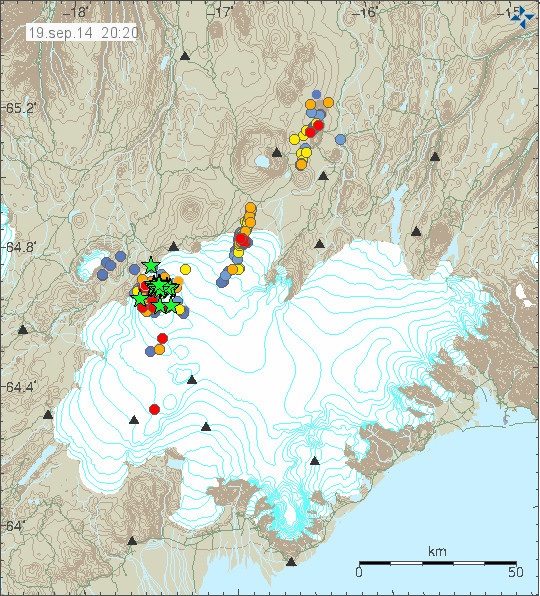
This is the earthquake activity from 20:20 UTC. It clearly shows the earthquake activity as it now is taking place. Copyright of this image belongs to Icelandic Met Office.
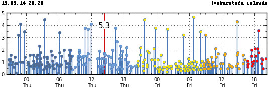
Magnitude of the earthquakes taking place during the past 48 hours. Copyright of this image belongs to Icelandic Met Office.
Update Saturday 20-September-2014 at 13:16 UTC
- Largest earthquake since midnight was an earthquake that took place at 01:10 UTC and had the magnitude of 5,1.
- Eruption at Holuhraun continues same as before. The central crater is now high above the flat desert that is in this location. I don’t know how high it is now.
- SO2 pollution have been noted over Iceland today. It has been seen in Reykjavík, Borgarnes, Akranes and other places. The amount of SO2 in this places is far below health risk levels according to the news.
- Minor earthquake activity continues in the dyke and has extended slightly more south since yesterday.
- GPS data continues to be confusing. GPS data from Icelandic Met Office can be found here. GPS data from University of Iceland can be found here.
Update Sunday 21-September-2014 at 14:35 UTC
- The eruption continues as before. There is no major change taking place in Holuhraun.
- Largest earthquake since midnight is a magnitude 5,5 earthquake that took place at 10:51 UTC. Other earthquakes have been smaller. This is the second largest earthquake since activity started in Bárðarbunga volcano. With the largest earthquake so far taking place on 26-August-2014 having the magnitude of 5,7.
- People have found going into the closed area and that is illegal. This is dangerous since there is high risk of new eruption taking place under the glacier south of current eruption. When that happens the glacier flood is going to coming down to the current erupting area within 30 to 60 minutes (1 hour). That is not enough time to send warning to all the people in the area. If you want to go to Holuhraun, rent a plane. Its the safest option at the moment. Don’t go by car! Small eruptions have been taking place under the glacier in past month. So we know they are happening, they have not been large at present time, but that is going to change without warning. There is also high risk of gas like SO2, CO, CO2 from the eruption.
- Dead birds have been found close the lava field in recent days or weeks. I don’t know why this happens, but it is clear that deadly SO2 gas and other gases are killing the birds.
- There is a storm in Vatnajökull glacier area today. As can be seen on Icelandic Met Office wind map here.
- Eruption in Bárðarbunga volcano is expected to take place without warning. It has not yet happened, but the chance of an eruption taking place is higher than it won’t happen.
- Bárðarbunga volcano caldera continues to subside. Latest drop was around 25 cm following the magnitude 5,5 earthquake.
I am going update this later today if there is reason to do so.
Article updated at 13:16 UTC on Saturday 20-September-2014.
Article updated at 14:38 UTC on Saturday 21-September-2014.
Article updated at 14:41 UTC on Saturday 21-September-2014.
Thank you, Jon, for this very insightful and thoughtful blog and for your continued efforts to enlighten those of us who visit.
I am saddened that some people choose to view this site and then act rudely towards you.
Well done for putting that person in their place (and I presume blocking them).
While I am mainly lurking, as I don’t feel that I know enough to contribute to the discussion, I wish to join those who are enthusiastic in their appreciation for your efforts here.
I know the most recent results on http://hraun.vedur.is/ja/Bardarb/BARC/ shouldn’t be overread, but isn’t it a bit strange quakes under the caldera have stopped entirely for now, while GPS still indicates subsidence? I see the same lull in verified caldera quakes via IMO’s main Vatna page and 3dbulge. I’m going to assume since 3dbulge shows a couple of unverified quakes, it’s just an exhausted IMO scientist conked out on his desk.
1. IMO verifies very few EQs during the nights, but there has been some 3+ and 2+ EQs.
2. There is a lot of wind in the area now, and then the smallest EQs is hard to detect.
I imagine a possible answer : the 5.5 quake yesterday has been followed by several biggish 3-4 ones, most of them closer to the surface. Hence the rock/magma under the caldeira floor down to 8.7 km could have readjusted itself after the big quake, allowing for further subsidence. Am I right ?
I know Jon has been very busy with his blog and eruption updates.
Think about the fact that there are a handful of places on earth that can host gigantic eruptions and Iceland is one of those places. What in Hawaii and other volcanic hots spots, would be relatively harmless fissure eruptions can, if in Iceland, blow into a Laki style mega eruption. BB has a history of very large fissure eruptions along the massive associated fissure system that extends SW and NE of the caldera.
Past eruption history indicates that BB fissure eruptions can be huge – more than 10 km3 of magma. That means fissure eruptions that did not take place under the icecap, but if we include those we the add the possibility of large tephra ejections. I’m not trying to be an alarmist here, but simply reiterating what Jon and the Icelandic geologists are worried about. Even a BB fissure eruption can be gigantic. Add in the BB caldera that is not always involved, and we have potential for a historic, for modern times, eruption. With all the sensors and cameras we are watching a potentially historic eruption.
This is already a very large eruption of a MORB fissure and sounds like its erupted volume is rapidly passing previous – recent that is – eruption volumes.
Perhaps is mentioned earlier but
here is a nice to read document about the
Bárðarbunga Volcanic system
http://en.vedur.is/media/jar/Bardarbunga_kafli20140825.pdf
enjoy reading it
Hi Rick, Thanks so much for the link. I have great interest but not a lot of knowledge and this is fantastic information.
Co-incidence but some times correlations May line up (emphasis on May)
In the document it is stated that the last eruption of Barda was back in 1910.
1910 was also a period of low solar activity. Solar cycle 14 dating from 1902 to 1913 showed the lowest activity since the Dalton minimal.
Current solar cycle 24 is a very weak cycle.
Co-incidence only ………. nothing concrete.
in the meantime it’s made clear by many” see earlier notes in all the threads” that our Sun, doesn’t have anything to do with magma movements below the surface of our planet
The Obama corelation was stronger
Wow, I didn’t know that how weak the solar cycle is affected by Bardabunga eruption 🙂
There are a few scientific papers looking at this subject. There was more correlation with active phases of the solar cycle and the possibility that different plates responded at different phases.
A very recent study.
http://www.suspicious0bservers.org/sun-trigger-large-earthquakes/
I wouldn’t use http://www.suspicious0bservers.org as scientific documentation.
I could not resist to post this link : ), for all of you who like to correlate unconnected things
http://tylervigen.com/
Have fun ; )
ps.: by doing this, one could learn the meaning of correlation
The documented eruption that took place 1910 in Bárðarbunga in fact took place in Hamarinn volcano south west of it. I don’t know why Global Volcanism Program has it like that. There was no eruption far as I know in Bárðarbunga volcano main volcano in 1910.
Great link Rick, thank you so much for sharing. Very informative, really puts the whole thing into perspective, I never knew that the “plumbing” beneath Iceland is that large and extensive. Bardarbunga really has a huge eruptive potential.
Heliospheric current sheet =>
1) Geomagnetism=>friction=>heat=>viscosity
&
2) Atmospheric Contraction & Expansion=> Earth’s Radiative Budget Equation=>Cryosphere=>Poleward Accumulating Lava Events (Seasonal)
lunar Gravitational tides conditionally express energy transfer by the boundary conditions of the heliosphere & potentiate interference as tectonic tipping points
see Jupiter’s gravitational impact upon the magmatic processes on Io
Looking at this document figure 1. the Holuhraun fissure seems to be located in the southern section of the Askja volcanic system to the adjacent right of the Bardarbunga volcanic system. Is there any significance to this? Has the Bardarbunga dike intrusion penetrated the Askja system?
Bárðarbunga dyke that is now erupting is in Askja fissure swarm that extends south of it. It didn’t reach the main volcano, but there was a high risk of that for a short period. It didn’t happen and an eruption started in Holuhraun in crater row that was created in 1797 eruption in same area.
@ Jon,
when you start your Q&A
please could you address the below topics as well
1. how to read the tremor plots
2.what type of tools are they using now a days like gps, temor plots, quake plots
– but are there any other future ” tools” to look under the surface which are still in development
3. how to read the data from the different tools in use
thanks so much for all the effort and info you provide
Another big one, 5+, on the drumplot.
Verified by IMO at m4.8
I suppose you have all noticed the increase of +3 earthquakes during the last few days. The ones today, this far, have been around 5 km NE and NNE of BB.
I cannot connect to any mila webcam from Germany for about 24 hours now (“server not found”).
Is anyone experiencing the same problem?
Yes, for me too. But I do get the Cam 1 on the Mila Youtube: http://www.youtube.com/watch?v=GKcCvbXzkCU
Cam 2 is stuck in the night.
Agreed, B.B does not need to blow for this to be a large scale modern event. According to the IMO.
Jón’s hekla geophone probably doesn’t work
sorry, it is OK again
This article is not related to the current situation at Bárðarbunga but I thought some of you might find it interesting in general:
http://m.livescience.com/47928-well-water-precursors-iceland-earthquakes.html
Apparently new chemical analysis of the lava at Holuhraun might have been done, by scientists on the field, but no one has disclosed it yet.
If first sample was slightly evolved, it could mean either 1) old Holuhraun magma, or 2) deep Bardarbunga chamber drained magma Second sample, if it exists, might explain IMO statement that magma comes more or less straight from under 10km deep at the moment and it will sustain itself.
The subsidience at Bardarbunga I think it could be explained alone just by the rifting event (which makes caldera sink as extensional forces create a void within). We don´t even need to think about drainage of the chamber, although that might be occuring too. Definitively we see a radial dike from Bardarbunga connecting to the original rifting regional dike.
I am sure that magma is deep sourced. As we have 1) seen plenty of deep earthquakes, 2) graphs seem to show a feeder dike, 3) gas-rich magma, 4) I would be willing to bet that a new analysis would show high MgO and lower Si, confirming the mantle melt sourcing of magma.
Hence, we clearly see a regional fissure dike evolving towards a shield volcano eruption, which is the common mode at the north of Bardarbunga.
If this is so, subsidience at the caldera is not related to drainage (since eruption is being mostly fed by the mantle now), but then why we see the caldera sinking? We have seen the GPS movements of rifting nearly stalling, so the caldera subsidience should stop.
There is something here that we still don´t know.
Someone should test that Askja basaltic lavas from 1875, the ones that erupted along a long fissure, and caused the caldera to sink. It´s the closest we get to the current situation.
Looks like there is a sustained uplift event in the caldera. It seems too sustained for the usual noise on the graph. Could be magma rising.
Yes seems to have risen 10cm so far. Waiting for graph to be up for a while so we can see if its corrected.
Small uplifts like this appear to be a precursor for larger earthquakes and drops in caldera height, pressure and stress builds than is released perhaps. Let’s see.
And there it is, back down after the 3.4 EQ
Pictures of the eruption at Holuhraun/Bardarbunga:
http://www.lukas-gawenda.de/bildergalerie/vulkanausbruch-island/
Please do not post your link many times, once is good enough. Too many times and it can be regarded as spam. It is fine if someone ask about pictures, but many times in the same article is no good.
You can always provide a link to earlier comment with the link in it. You just select the date – time on the comment get the direct link to it and post that.
Hello,
thanks for the spectacular Photos! Could you tell us how Did you get this close to the Volcano as the area is offical closed. Did you got a special permission?
Best Regards
Thank you, but youtube says:
“Live streaming due to legal issues in Germany not available”
I am getting withdrawals…
http://www.lukas-gawenda.de/bildergalerie/vulkanausbruch-island/
is not youtube. Try cutting the link and pasting into you browser.
Is my link not working?
Try this one:
http://www.lukas-gawenda.de/bildergalerie/
Then click the volcano picture to see my volcano gallery 😉
sorry my post was meant as answer to hen’s youtube-link above, but it showed up as new topic, dunno why…
Germany does not allow for live broadcasts to more than 500 peoples without licence (for each broadcast). This is in some old anti-piracy laws that where used against pirate Television stations and radio stations.
So is this the reason for the mila webcams to get disconnected from german IP’s or only for the youtube-issue?
This is only Youtube issue, since Youtube operates in Germany. Míla is only located in Iceland and not subject to Germany laws on this.
A few people have experienced difficulty viewing the Mila Webcams Bardarbunga 1 ans 2
I have had occasional trouble but always managed to get on eventually. But I have not been able to access the site for over 24 hours, and I am having withdrawal symptoms! has anyone else had that trouble and is there another webcam that can view Bardarbunga it just says server not found
http://www.livefromiceland.is/webcams/bardarbunga
Can’t get mila webcams from England today.
Use this you tube relay: https://www.youtube.com/watch?v=n7W9DLxLh8g
Live cams not working for me in the UK either, but so long as someone is operating a youtube relay that’s fine by me.
I wrote to mila -> CONTACT-form on livefromiceland.is (1h ago) and now the cams are working for me (from Germany).
What is Grimsvotn doing?
http://strokkur.raunvis.hi.is/~sigrun/GFUM_3mrap.png
Ice on the antenna?
That was the previous explanation
this morning there was some fog but the visibility is OK again
http://brunnur.vedur.is/myndir/webcam/2014/09/22/webcam_mogt_kverkfjoll_20140922_1340.jpg
Bilder sind ok.
Trotzdem nervt das dauernde posten deines links so langsam, Lukas.
Im Nachbar-Forum wurdest Du von den Admins schon drauf hingewiesen…
@ Lukas
Your pics are good.
But posting the link to them over and over again becomes spamming…
Looks like another big quake has just happened hard to say how big.
Monday
22.09.2014 13:36:02 64.671 -17.460 7.3 km 4.7 99.0
Hard to tell from this it might be smaller
http://hraun.vedur.is/ja/drumplot/dyn.png
Mila cams seem to be back 😀
Finally!
I’ve had no trouble at all with the Mila webcams for several days now, except for one brief period (just a few minutes, really). I assume they were doing some kind of maintenance then. Not sure why others are having a problem. Of course, having said that, I’ll probably be the next one to be unable to access them.
Today this dark plume really looks toxic.
You almost can smell the sulfur…
Sulfuric smells:
– lighting of a match smell, bluish fog: SO2 (sulfur dioxide)
– rotten egg smell, brownish / orange fog: H2SO4 (sulfuric acid)
The last one is called “hveralyktin” in Iceland, which means the “smell of the hot springs”.
New article is up on current activity in Bárðarbunga volcano.