
This information is going to get outdated quickly.
Current status on Bárðarbunga volcano at 20:36 UTC
- Largest earthquakes in Bárðarbunga yesterday (17-September-2014) was a magnitude 5,2. Largest earthquake today (18-September-2014) was a magnitude 5,3. Other earthquakes have been smaller.
- Bárðarbunga volcano caldera continues to drop. When the magnitude 5,3 earthquake happened today at 14:21 UTC the caldera dropped 20 – 30 cm.
- GPS data (more GPS data can be found here) suggest to me that the dyke at Vonarskarð might be getting ready to erupt or getting re-activated. It formed in the first two weeks when current activity started in Bárðarbunga volcano on 16-August-2014. It is already there, it however failed to start an eruption, but as I say, it might be getting ready to get active again. This has been followed by some minor earthquake activity. There is however a more complicated picture into this. The details can be found later in this article. [Please note that due to licensing issues I only link to the GPS data. This means that data on the link is going to get updated in next few hours and are going to look different from what I have written about them now.]
- The eruption in Holuhraun continues as before. There has not been any view of the eruption for the past two days due to fog. So I don’t know for sure what is happening there.
Harmonic tremor data
I can see two things in the harmonic tremor data. The pressure is increasing in Bárðarbunga volcano system. I am also seeing pulses of harmonic tremor and that is not good. It means that magma has somewhere found a path to the surface, it just isn’t there yet, but it is working way up. It is impossible to know if this magma gets all the way up or not. Small eruptions are also not impossible, since there signature might simply be lost in the noise on the tremor plots that I am using from Icelandic Met Office.
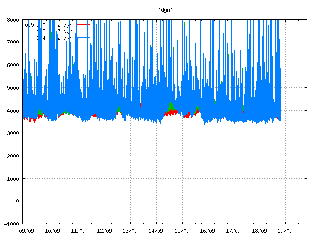
Tremor in Dyngjuháls SIL station. Copyright of this image belongs to Icelandic Met Office.
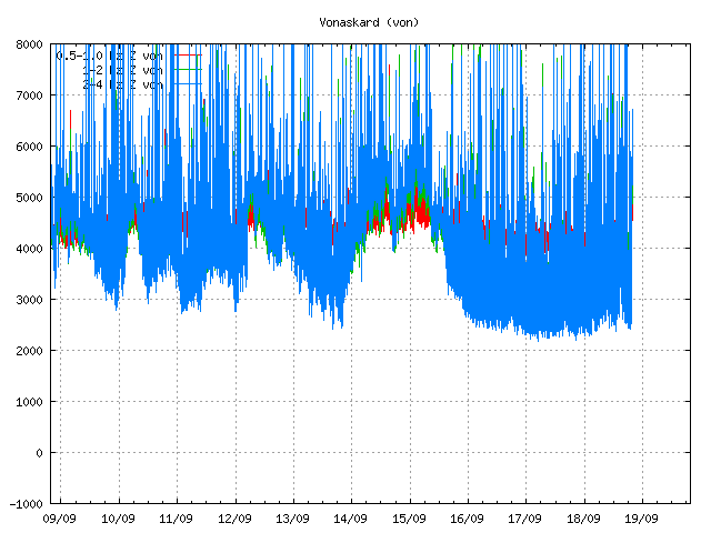
Tremor on Vonaskarð SIL station. Copyright of this image belongs to Icelandic Met Office.
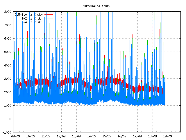
Harmonic tremor as it appears on Skrokkalda SIL station. Copyright of this image belongs to Icelandic Met Office.
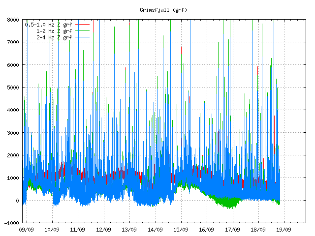
Harmonic tremor on Grímsfjall SIL station. Copyright of this image belongs to Icelandic Met Office.
Current status on the cauldrons
According to the news that I have heard some of the cauldrons that are in Dyngjujökull (south of Holuhraun) are still getting deeper. This suggest that there is still a lot of warm under the glacier that is melting the glacier. No glacier flood has happened due this. I don’t know if any new cauldrons have formed in recent days. Most of the cauldrons are located above the dyke, few are located above Bárðarbunga volcan in its slopes.
Tungafellsjökull volcano
I am seeing in the GPS data that Tungafellsjökull volcano might be getting more magma inflow. Since it appears to be inflating. This has not been confirmed so far. Currently there is nothing to suggest that Tungafellsjökull volcano is going to erupt at this point in time. It might simply be responding to the all the noise that Bárðarbunga is making at the moment, along with stress changes in the crust. If it erupts, it would be first documented eruption in the past 8000 years at least (maybe longer).
Next update is going to be tomorrow or sooner if anything major happens. It is possible to watch my webicorders here. They are updated every 5 min.
Article updated at 21:05 UTC.
Article updated at 21:14 UTC.
Plane circling the eruption as I write this.
Helicopter?
Or that.
Could be scientists, could also be tourists. There are some firms in Reykjavík and at Mývatn (perhaps also Akureyri) which are organising such tours.
Sorry, innocuously was the adverb 😮 I can’t even read me dictionary… I shall concentrate on watching the volcano, my senility can cope with that 🙂
I also make mistakes like all of us .. 🙂
Helicopter, considering it’s pretty much parked over one spot, lol.
Absolutely mesmeric (Definetly had too long a break for a webcam fix <3 http://i57.tinypic.com/2yzgepz.jpg
This lava flow is going to, at some point soon, start damming up the river pretty good here on the east side of Vadalda where the cams are located. Between Vadalda and Rifnihnjukur, on the other side of the river, it narrows down from the wider plain. Sure would be nice to see an updated map of this flow. Hopefully IMO will post another one soon.
This is a good reference map of the area with all the various names.
http://atlas.lmi.is/kortasja_en/?x=597854.7685280954&y=483198.1473930675&l=4&anno=1&bm=2
Where Svarta and Jökulsa are meeting is a little Waterfall, perhaps it is gone now
http://atlas.lmi.is/kortasja_en/?x=597854.7685280954&y=483198.1473930675&l=4&anno=1&bm=2
http://www.mbl.is/frettir/innlent/2014/09/12/fossinn_skinandi_kann_ad_hverfa/
Skinandi is the name.
Possible. Could be that the recent rains brought the Svarta river up some, and is causing a lot of the steam now in front of Vadalda as the lava expands in this area.
A pretty little falls. It will be interesting to see how it changes.
And Brian, I also agree with your comment about the rainfall increasing the steam.
I’m itching for more data and pictures about the rivers.
Has the wind changed or fog returned on bardar cams?
It’s not over until earthquakes return to the rest of Iceland.
Vatnajokull aside, The rest of the seismic network seems hugely quiet for a long interval. This has impressed me about the Bardarbunga eruption
When this event started I noticed the same thing. Earthquakes in other areas really slowed quite a bit.
It looks more like an oil torch or a gas torch than an eruption tonight
Looks more like an oil or gas torch than an eruption tonight
Perhaps this is a silly conjecture from an ignorant layman . . . however, as I looked at the quake lines at this link:
https://maps.google.co.nz/maps?q=https:%2F%2Fgoogledrive.com%2Fhost%2F0B4z7bEYG56MqMDg2c0o5R3g0dms%2FMag5Vatnajokull2014AugSept.kmz&hl=en&ll=64.650348,-17.438736&spn=0.168451,0.676346&sll=-40.924632,175.00643&sspn=0.148639,0.338173&t=p&z=11
It SEEMS to me that one could loosely construe a Northern sort of line toward the East from the North center of Bardabunga
and then another loosely appearing line South toward the East from the South center of Bardabunga.
Maybe I’m seeing a hint of a pattern where there is none. But I was wondering if those more trained and experienced in looking at such things could comment . . .
Where is the RIFT in that region?
Is it too far fetched to imagine that the Northern sort of line on that map is on one side of the RIFTING feature from the Mid-Atlantic Ridge
and the other Southern sort of line is on the other side of the RIFT?
Or is the RIFT located at a distance from those quakes and not directly related to them?
Or is, perhaps, a new collateral sort of RIFT possibly beginning to occur between those two ‘lines?’
Just brainstorming as an ignorant layman here. Am not easily offended so feel free to shoot it down.
I just happen to think that our collective discussion MIGHT turn up bits and pieces that more well trained folks with their noses to the traditional grindstones might miss. Not that these questions of mine above would fit that category. LOL.
I’ve been accused of being ‘overly strange’ and ‘far out’ several thousand times in my many decades of living.
This is a map of Iceland including tectonic plates http://pubs.usgs.gov/gip/dynamic/graphics/Fig16.gif
Ring around the Bardarbunga caldera.
http://en.vedur.is/earthquakes-and-volcanism/articles/nr/2949
Whole crowd of people at the radome.
Sorry for the late updated. There has been a plague of mosquitoes bothering me for the last 24 hours or so. That has resulted in me not getting a decent sleep, whit them buzzing around and being annoying.
That’s no way to talk about your loyal followers. 🙂
I don’t mean you. I mean this thing here.
https://en.wikipedia.org/wiki/Mosquito
Extremely annoying and there is a lot more of them due the heat Denmark is now experiencing. They don’t bite me, since I appears to have natural repellent against them.
With all the different cloud features, and the orange glow, sure has a hellish look tonight.
Incredible view tonight with the alternating light and dark cloud bands… this is what it must look like in Jupiter’s atmosphere!
New article is finally up. 🙂
Some *very beautiful* images in the following video,
Lava Fountains from Bardarbunga Volcano Holuhraun Fissure Eruption viewed by Helicopter Flights: YT-user:Photovolcanica
https://www.youtube.com/watch?v=fmCJSS2YAP0&feature=em-uploademail
Great pics of the river and the flowing lava interface:
http://icelandreview.com/news/2014/09/15/photos-lava-flowing-river
Here’s a great map with 6424 quakes of the area illustrated on it by
New Zealander “Muzzy” of ATS
(AboveTopSecret.com):
https://c282f854f1725756c6651c912de317f323b38e66.googledrive.com/host/0B4z7bEYG56MqOEQ4OTR5RkVzOGs/6424earthquakes11082014-19092014.png
He’s a great Quake Jockey Extraordinaire along with Puterman of the quake and volcano threads at that site. IIRC, they are laymen but with a ton of experience and perceptiveness studying such things.
Looking at his map . . .IT APPEARS
to me
That the fissure quakes that are under the eruptive part of the dyke . . . are QUITE SIMILAR in intensity/frequency UNDER THE GLACIER as compared with those going NE beyond the edge of the glacier. DOES IT APPEAR THAT WAY TO ANYONE ELSE?
Therefore what, I don’t know, as an ignorant layman.
But it kind of strongly hints at, to me, the likelihood of some degree of eruption under the glacier???
But then, where’s the water runoff?
Could some trained experts comment on the issue(s) related thereto, please?
The water is trapped, does not release until a way out is made.
At the current SO2 release rate (presuming 75K tonnes/day, right in the middle of current provisional estimates), we’d “only” need 4 1/2 years to match the estimated total release of Skaftáreldar/Laki 1783-4. The current rate looks to be around 5-7 times the total emissions of the EU-28.
The lava effusion may not be all that bad at present, but the composition of this somewhat mature material doesn’t look too benign.
A subglacial eruption would make things a lot more interesting.
A couple of questions
What is the date of the last eruption from the main Bárðarbunga crater, I mean from within the crater, not on it’s flanks or as fissure eruptions?
What date was the existing main Bárðarbunga crater formed?
Jon,
Re mosquitoes etc. I’ve laid a folded-in-half (or so) T-shirt across my head covering my ears and sometimes my eyes–in such situations. Has helped a lot to result in a good sleep.
BTW, Vitamin B-6 taken daily for 30 days or so seems to result in a smell that mosquitoes don’t like. I used to be the only one they’d swarm to devour. Vit B-6 has made me untasty, it seems. YEA.
Thanks for all you do for the rest of us in this dramatic sequence of events.