
The eruption in Holuhraun ended yesterday (27-Februar-2015) it seems. Current status of Bárðarbunga volcano is now yellow. While the eruption is over the area continues to be closed for public due to danger of new eruptions in the area, both outside the glacier and inside it. It is unclear what is going to happen next in Bárðarbunga volcano. There is also a considerable gas emission from Holuhraun crater at the moment and that gas is toxic.
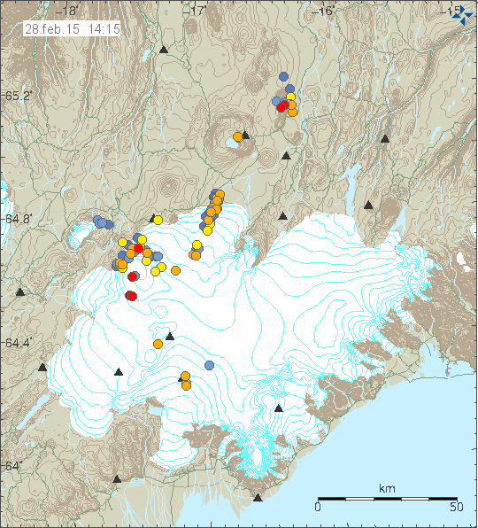
Current earthquake activity in Bárðarbunga volcano and for the past 48 hours. Copyright of this image belongs to Icelandic Met Office.
What happens next is not known. There is a high risk of new eruption taking place under the glacier. I don’t know if subsidence of the caldera is going on at the moment or has stopped. It might take days, weeks or months until inflation starts again in Bárðarbunga volcano. This is a rifting event and that means this is far from over. For the moment however it is going to be a little break (at least, it can be hope) in the activity in Holuhraun or Bárðarbunga volcano. The lava and the crater continue to be extremely hot (~800C) and are going to remain hot for many years (5 years?).
Since the eruption in Holuhraun is over I won’t post any update next Wednesday. Next update is going to be when something happens.
Icelandic News
Icelandic Met Office information website
The eruption has come to an end (Icelandic Met Office)
Note on email: If you need to send me email please send them to volcano [at] jonfr.com. I do not answer emails send to blog [at] jonfr.com. Emails that go this address are ignored.
Article updated at 16:59 UTC.
I absolutely agree Jon, the area will remain very hot for a long time.
This has been a fascinating experience for me. I’ve kept up reading all the postings and comments and have learned a great deal. I look forward to the next chapter in Iceland’s volcanic activity. Jon, let it be known your Asperger’s should have zero negative affect on anything in your life, but others see things differently. You run a well put together blog that is informative and understandable. For that, thank you! 🙂
Also, try to not think your situation of being stuck in Iceland (as opposed to Denmark) is impossible. I think good things are ahead for you.
Well put. I agree with you!
I discovered your blog, Jon, via a series of diaries @ http://dailykos.com dealing specifically w/ Bardarbunga. I am grateful to that diarist (rei) for her excellent work and for bringing me here.
In another life, I would have been totally happy as a vulcanologist – I would be totally happy as one now, but I’m 63 w/ no diplomae, so I eat them up, as we say, on my own and not just for ‘lava porn’. Deeply fascinated by the processes driving the life of the earth, but vulcanism, tectonics & related most especially.
Thanks for your hospitality, and for your patience with my questions – I have every reason to come back!
I came here by way of the same source (rei), who spoke highly of your opinions. Being quite ignorant of vulcanology, I have mainly lurked, but have learned a lot, and will continue to follow you on social media…just in case something else interesting happens up your way.
Thank you for your good work.
I think there has been a tremor spike which is shown on different SILs during the night from 26th to 27th:
station djk (Dyngjujökull) around midnight: http://hraun.vedur.is/ja/vatnajokulsvoktun/djk1_trem.gif ;
a little later at station kre (Kreppuhraun, in the Kverkfjöll area): http://hraun.vedur.is/ja/vatnajokulsvoktun/kre_trem.gif ;
and some hours later at grf station (Grímsvötn): http://hraun.vedur.is/ja/vatnajokulsvoktun/grf1_trem.gif .
Could it have been a small eruption under Dyngjujökull glacier or within the eastern part of Bárðarbunga and the melt water arrived some hours later in the subglacial lakes of Grímsvötn like in 1996?
Also the station hus (Húsbondi) has been rather lively now for some time: http://hraun.vedur.is/ja/oroi/hus.gif Is it part of the surveillance for the southern Bárðarbunga-Veiðivötn system? Or more surveilling the – also volcanic – Skaftárkatlar?
I think that this is related on data transfer problems / lost connections … it was also visible in the drumplots at that time.
Surely if anything was happening the 2 to 4hz ,blue line, would be active?Is not this the range associated with the movement of magma?
As far as I know, magma movements are indicated esp. by the red line, ie. the low hz range. The blue line indicates bigger events or influences like the weather, sea waves, even car traffic near streets.
I have one question: Now that the eruption has ended, shouldn´t the tremor graphs go to rest? I don´t see much change.
http://hraun.vedur.is/ja/oroi/von.gif
Yes
And they have been around this active since 16 august 2014, which is why it would be foolhardy to assume it is over. Notice also the extent of smaller eqs across Iceland.
Also the Icelandic scientists like eg. Páll Einarsson and Katrín Jónsdóttir are taking into consideration other eruptions which will very probably follow – just nobody knows when or where exactly. http://www.mbl.is/frettir/innlent/2015/02/28/likur_a_fleiri_gosum_i_kjolfarid/
The reasons are that this is typical for rifting events like this one and also for the Bárðarbunga-Veiðivötn system acc. to its eruption history.
The smaller dikes in the extensive dike system have been gradually filled with magma, which then solidifies to close these pathways.
As existent pathways for the magma are closed, new pathways are forced open by pressure which then also solidify.
This will continue until magma pressure rises enough to force eruptions at the surface either at several remote sites or along the ring fault of Bardarbunga.
There was a spike re. SO2 in the town of Blönduós in North Iceland today (around 1100 μg/m3) http://ust.is/einstaklingar/loftgaedi/linurit/?station=crblonduos
I suspect that a lot of this off gassing is originating from the caldera itself?The gas levels are out of proportion to the magma being erupted from the dike?Which is no longer erupting.
I am just about ~40 km west of Blönduós. I didn’t notice any pollution today when I did go out around 17:00 UTC. So it must have been localized spike in SO2 pollution. The wind direction now is from the north and has been that at least since around 14:00 UTC. There continues to be strong gas pollution in Holuhraun from magma at depth (~100 meters) in the crater. That gas pollution might last for weeks or months depending on what is happening in the crust.
The scientists are supposing that the gas emissions from the lava field will still go on for months or perhaps a year.
The biggest problem in this case are the heightened emissions of CO2 and carbon monoxide, as they don’t have a typical smell and could be gathering in dangerous concentrations within hollows around the lava field. Experiences from other eruptions indicate that the emissions of these gasses go up after the end of an eruption. There was a case of two policemen who almost lost conciousness after have lent in such a hollow. And the concentrations can even be deadly. http://www.mbl.is/frettir/innlent/2015/02/28/gasid_gaeti_leynst_i_laegdum/
Thanks Jon for all your prompt and well put together updates on this, and helping bring together a community of people where so many fascinating things have been discussed in good spirit too. I’m sure I’ll be reading here again soon enough, just that this was the end of one phase of the wonder that lives and breathes beneath the country where you are so lucky to be – enjoy!
Oh, how sad to finally have the current eruption come to an end, but how exciting to wonder what will happen next! Jon, you do a fantastic job with your web site, and I have learned so much. I will continue to follow your blog, and I will lurk about at least once or twice a day to see what is up with Big B and the rifting event. I am just beginning to discover that I have a fascination with geology.
All finish for the next century?
INDEED, Jon,
Congrats on your good coverage of an exciting event and over the long haul of the quake and volcanic changes in the land of your birth.
I suspect things will get more interesting again before too many weeks or months have passed.
Well done Jon on your analysis, blog and the way you manage people posting comments. The whole episode has been fascinating and I have followed your blog since the 2010 eruption. You live on an amazing geological island and I look forward to the next chapter!
Kudos!
Fast inflation on barda GPS now? Or it will be corrected? http://hraun.vedur.is/ja/Bardarb/BARC/barc_gps_3d_is.png
it’s correcting it seams…
I would doubt that you will see any rapid inflation where the gps is situated.The magma at Holuhraun had a source depth greater then 10km,doubt that magma that deep could inflate the caldera floor rapidly,maybe a shallow magma source could.I would not waste your time watching for inflation proceeding any caldera eruption ,in the unlikely event a caldera eruption happens,warning would most likely be hours to a few days at most?
Well it was a so steady movement… very amusing to see, and still marked.
http://icelandreview.com/news/2015/03/02/scientists-sub-glacial-eruption-bardarbunga-likely
Can’t disagree with that, the data is all pointing that way.
I’m no geologist (not even armchair), even i don’t think this has finished.
Just a short lull before something else happends, is what i think.
You are right, the next eruption could be quite soon. Although Iceland will never be quite for a long time, as the MAR spreading is a continuous process, couple of centimeters every year. It’s just not so easy to spread the massive Icelandic land mass than the normal ocean floor. Hence we have eruptions only every couple of years, up to five years in average, while the MAR is active most of the the time.
Fantastic Landsat 8 satallite picture from yesterday, 1st March 2015.
Now we can see with our own eyes, that BB has really subsided a lot.
Taking the light- and shadowfall in account, there are some small but fairly deep cauldrons to the SE and W in the caldera.
http://en.vedur.is/earthquakes-and-volcanism/articles/nr/2947#mars2
The development of the cauldron in the west part of the caldera rim is something that needs to be monitored more closely. The cauldrons in south part of the caldera are in locations that are above the dyke intrusion and that location already has shallow magma (>1 km depth) in the crust.
I don’t see any other clear features on this image at current time. At least nothing that I can work out clearly.
EQ count seems to be increasing. Red dots all over the place.
There is almost no wind at the moment, making those small EQs easier to detect. I believe this has been going on all the time over the last weeks or a month, but it has been constantly windy. Today it is calm:
http://en.vedur.is/weather/forecasts/elements/
These small quakes show that this event in the BB system is – as stated again and again – is not over.
But right now we’re in between two eruptive states with no imminent threat to the community. Time will tell what will happen next, as these big rifting movements are almost totally unpredictable for any longer duration. IMO and volcanologists in general hold some scenarios more likely than others, as stated in the continuous updates.
I wonder if the next eruption will be close to Askja or above it where that new line has appeared recently?
Yes true but there are rumblings 6 miles underground. with a downward trend.
and more power is no longer available.
Please remember to support my work with donations. I am going to be rather broke this month since I am paying down debts and bills since I lived in Denmark (it’s a long story and I won’t write it here).
Activity in the dyke and arrownd Grimsfjall is rising…
For an eruption that has now ended, things seem very active. Why is there a line of quakes between Askja and Herdubreid? Also, what is going on in the dyke and Bardarbunga? Lots of small quakes there, too.
Holuhraun eruption has ended, rifting event has not.
Rifting is never ending. I would be interested to see an earthquake map from that area, let’s say from January 2014 or even August 2013. Was it absolutely quite, or did we have little earthquakes then too?
There have been small cluster over the years, a cluster of around 30 in September 2010 was the most recently before the current event if I recall correctly.
Oskjuvatn (in Askja) didn’t freeze as much as expected in winter ?2013 and this prompted IMO speculation about renewed activity beneath the caldera. Then there was the landslide in Askja in ?July 2014.
Thanks, John. So this is indeed a very active period, more to come.
Andrew, do you have any article or pics about the Askja landslide?
Stefan: There was a news article with good pictures on the IMO website – written in haste, so can’t trace link, sorry.
I found it! A tsunami in the middle of the Icelandic Highland!
http://en.vedur.is/avalanches/articles/nr/2929
Well, that’s an updated article that has much more info in it than the one I read last year, so thanks for the link!
Villarrica volcano (Chile). Red alert with evacuation of populations near volcano.
http://sitio.temucotelevision.cl/2015/03/volcan-villarrica-hace-erupcion.html
Now this is quite the spectacle! Wow! The video at the bottom of the page is especially shocking. I’ve never seen lava fountains like that in my life.
The BBC has mentioned the lava fountains have reached 3300feet (1000 meters) high.
https://www.youtube.com/watch?v=RI_aOgxJBEc
Jon, I second all the kudos for you listed above. Your blog enables us to experience these events in real time, to share them, converse about them, and learn. Thank you to everyone who is or has contributed, but especially to you, Jon, for making it possible.
I have updated the eruption history list that I keep here with latest information.
http://icelandgeology.net/?p=765
Good and to the point summaries! It’s great to have them listed like that, easy to scroll.
Many of the seismographs in the BB vicinity pick up something that doesn’t look like an ordinary quake to me. It’s stronger but has a shorter duration in some stations and is more ‘stretched out’ in others (below). and doesn’t look like a sudden rise in wind, either. Magma rising, or what? IMO site hasn’t picked it up yet.
example @ 21:08
http://hraun.vedur.is/ja/drumplot/urh.png
You are right, Z.
Double quake at Reykjanes ridge!
http://en.vedur.is/earthquakes-and-volcanism/earthquakes/reykjanesridge/
Which magnitude they had, I don’t know. IMO changed from M3.3 and M2.8 to M4.0 and M3.5. And now back again to the lower magnitudes. mmmh o_O
Ah, I didn’t even think about checking the whole country before I posted the above comment. I’m tired today. 🙂
Hm!
Does an M3 and M2 at such a depth – 10.0km – far west of the Reykjanes rift usually affect the drumplots over at Vatnajökull like this?
Rift… of course I mean fridge.
We have wintertime. Reykjanes Fridge is legitimate.
😛
Hekla? Wednesday
04.03.2015 14:43:25 63.878 -20.026 9.2 km 0.8 99.0 17.5 km NE of Hvolsvöllur
Wednesday
04.03.2015 13:41:32 63.971 -20.000 7.7 km 1.1 99.0 14.6 km ESE of Árnes
Wednesday
04.03.2015 13:01:46 63.967 -19.999 7.9 km 1.3 99.0 14.8 km SE of Árnes
Wednesday
04.03.2015 07:42:58 63.987 -19.737 0.1 km 0.4 99.0 3.4 km W of Hekla
Wednesday
04.03.2015 07:40:16 63.995 -19.734 0.0 km 0.5 99.0 3.2 km W of Hekla http://en.vedur.is/earthquakes-and-volcanism/earthquakes/myrdalsjokull/#view=map
Wednesday
04.03.2015 18:29:38 65.143 -16.404 5.5 km 2.9 99.0 4.3 km SW of Herðubreið
something more than weather is happening
http://hraun.vedur.is/ja/vatnajokulsvoktun/von1_trem.gif
And now, another spike.
I don’t know if these are from the same or different places.
Hot and cold pixels at Holuhraun 🙂
https://twitter.com/EIlyinskaya/status/573389416510705664
and also from Ellynskaya
Inside the main crater:
https://twitter.com/EIlyinskaya/status/573215261765058560
one more pic: http://en.vedur.is/media/jar/myndsafn/full/ArHo_holuhraun-20150304.jpg
and the full report:
http://en.vedur.is/media/jar/skyrsla-rannshops-eldfraedi-natturuvar_JHI_20150304.pdf
Thanks for posting these links. The images remind me of walking around the rim of one of the Krafla Fire craters a day or two after an eruption had finished in 1980: blue smoke, as in the picture posted, but also a couple of really nice, scorched holes (ca. 5m radius) at the bottom of the crater waiting to swallow me if I slipped!
Oh, and I beat a hasty retreat when I started wheezing and coughing from the gases. Didn’t know about CO and SO2 emissions from eruptions then!
According to news tonight next eruption is going to start without much warning. No earthquake swarm is going to happen as was the case on 16-August-2014.
Ties in with what I said earlier.
Interesting. Thank you for passing that on, Jón. Was any reason given for the relative lack of warning?
System is primed, magma is close to the surface?
No, there was no reason given for this assessment. There is going to be some earthquakes in my view, but they might all be small and with magnitude less than 3,0 when next eruption happens.
It is already known that magma is in few areas close to the surface, less than 1 km. That means it doesn’t need to break a lot of crust to get to the surface.
Thank you, Jón. That makes sense to my very amateur mind.
Was the warning for a subglacial eruption?
jon flooding will go to south, bridges will go but no human damage
imri
It’s interesting that there are less quakes in Bardarbunga caldera and a building up along the dyke…
There appears to be very gradual inflation of the BB caldera over the last few days according to the IMO subsidence graph.
Thank you for all the information you bloggers share on this site. You are all the best! Things may heat up soon. So, I will be keeping a close watch on all news and Jon’s site. 🙂
There are rumblings under the ice cap
A jokulhlaup to the north might be brewing
http://hraun.vedur.is/ja/vatnajokulsvoktun/djk1_trem.gif
Looks more like instrument noise or signal noise to me?
There looks like there could be a little inflation showing on the GPS on Bard
Yes, and station gfum is showing GPS movement when it has been fairly settled for a while. Early days yet, but it is a change of direction and the inflation is slight. Tremor on sils remains high.
Hello.
The activity has settled down, for now at least, but as an uneducated to these matters a have a question;
Compared to the earlier drumplots some EQ’s at von seems to be massively under-repoted. Two quakes this morning at apx. 07.05 and 08.06 for today, and a few others over the last week. So. Are they using a very different scale now, or is there something else I am missing here.
This puzzles me a bit, so I hope someone has an educated answer. 😉
Thank you for all your good work Jon. Keep on going!
Spring is on it’s way people. 🙂
I’ve wondered the same thing, especially about those two large-looking ones this morning.
Although depth and magnitude are clearly factors in how an eq shows on the seismographs, I haven’t been able to see a pattern to the way they get recorded on the IMO page since the eruption finished. Perhaps the bad weather this winter has been a factor.
Anyone else?
I think that during nights weekends holidays the IMO staff hold off these non-essentials till morning. The EQ have to be hand checked first.
Yes, I’d spotted the backfilling of EQs. What I have been wondering about is that although the scale on the seismographs doesn’t seem to have changed (roughly since the end of the eruption), the recorded EQ magnitudes look different now (ie smaller) relative to the size of the deflection on the seismograph.
On the mila cam 1, is that a large area of melt on the far glacier ?
Dike events west of Bárðarbunga
07:04:59 64.640 -17.600 4.6 km 1.9 99.0 3.4 km W of Bárðarbunga
08:05:56 64.647 -17.613 7.6 km 2.0 99.0 4.1 km W of Bárðarbunga
Good news. The geophone in Heklubyggð is back online. A power outage restarted it’s internet connection. The geophone computer was working the whole time.
Volcanologist Haraldur Sigurðsson latest blog in Icelandic, about the caldera beginning to inflate.
http://vulkan.blog.is/blog/vulkan/entry/1652034/
Looks like it from the graph. Seems to have bottomed out around 20 February.
I’m wondering if the sliding ice mass contributes to the way the curve looks on top of the ice. IMO said it does.
But,but,but,he said the eruption would be over this month!I think these guys have privately had an idea of where this is heading for months,the only doubt being what the conclusion will ultimately look like?
Would someone mind translating Haraldur’s post to English? Thanks
http://icelandreview.com/news/2015/03/10/volcanologist-bardarbunga-caldera-starts-rising-again
Eventually the IMO will measure caldera subsidence under the ice cap from the air with ice penetrating radar. That will tell us whether we should choose A or B.
Until then, it’s a coin flip.
The weather in Reykjavík at the moment.
http://www.livefromiceland.is/webcams/reykjavik/
i love that weather
it’s not in finland now maybe in april
and you have not anymore so2
Weather today:
https://www.youtube.com/watch?v=IUdW973qAtM
…and some days before…
https://www.youtube.com/watch?v=c82rvKA1CuU
Hope that springtime someday comes back to iceland…
Cricky, that is some weather. Where i live we haven’t much of winter apart from a few chilly days here & there!
The best thing is almost no flooding compared to last year!
New article about Bárðarbunga volcano is up. 🙂