
This is the update for Bárðarbunga volcano on Friday 31-October-2014.
Not much has changed since Wednesday (29-October-2014) update in Bárðarbunga volcano. Earthquake activity continues as it has been doing for the past two months. No major change has been taking place in according to GPS data. No major change has happened in eruption vents in Holuhraun, the lava field is now around 65 square kilometres in size.
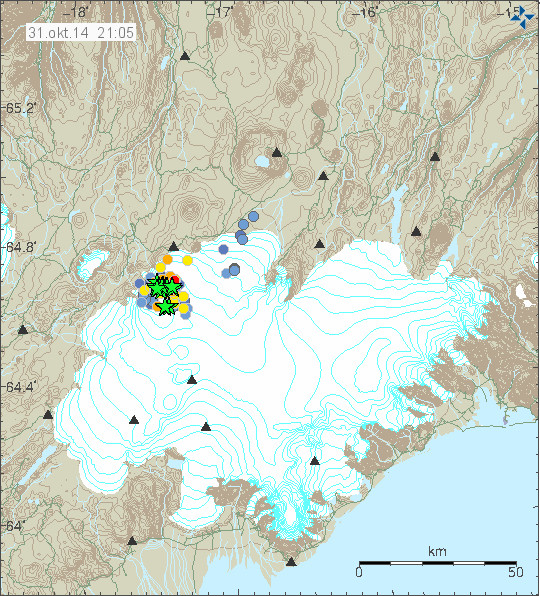
Earthquake activity in Bárðarbunga volcano for the past 48 hours. Copyright of this image belongs to Icelandic Met Office.
Strongest earthquakes for the past 24 hours have the magnitude of 5,3 and 5,2. Other earthquakes have been smaller. There is no change in earthquake activity in Bárðarbunga volcano and the caldera continues to drop around 40cm/day at the moment. Current SO2 output levels are around 20,000 to 40,000 tons/daily of SO2 from the eruption in Holuhraun. Bad weather has blocked proper earthquake detection and monitoring of the eruption in Holuhraun and of Bárðarbunga volcano. The weather is going to be extremely bad in Iceland for the next 6 – 10 hours. Other than this I don’t have any more news of Bárðarbunga volcano eruption.
Article updated 01-November-2014 at 00:30 UTC.
The weather looks terrible. Thanks for the update.
@IngeB thanks for the translation on the photographs! Really helpful 🙂
Another big quake just now…
… sometimes it is better to check first … before post!
?
Caldera drop just went the other way, rising 1.0 metre.
Thanks for the update Jon, well you are now famous Jon at our local school. My grandson who is 7 has been following these posts with me as he has been learning about the earth at school. This Friday they had an assembly where a select few of the children give a short talk on what they have been learning about, and Mark my grandson gave his on volcanoes. I will give a short rundown of what he said.
“Volcanoes have made the world. There is one in Iceland that is doing that now.” (This is we’re he made a small mistake). ” My grandad has a friend in Iceland called Jon who is very good and knows all about there volcanoes. He said that nearly all the volcanos put out balsamic lava (not an error) and the one in Iceland has made lots of new land. Jon also said that it is very dangerous to honest any volcano as they have gas and it could make you very ill.”
We’ll there was a few laughs and comments that that much vinegar would give anyone gas, but he still got n A- for his two min. This is the second time he has got his words mixed up, but you have got to love it.
Keep up the good work Jon. You have more influence than you think, even in my 7 year old grandson.
Auto correct gggggg should read very dangerous to go near.
Magnitude M 4.0
Region ICELAND
Date time 2014-11-01 05:59:15.3 UTC
Location 64.60 N ; 17.83 W
Depth 10 km
Source EMSC (not confirmed)
OK . . . I once thought I had begun to understand how the differences in
TNT EQUIVALENTS could be determined.
http://files.abovetopsecret.com/files/img/kh545469b5.png
But actually, I think I still don’t have a clue. Could someone please explain it to me?
It looks like Bard had a big day yesterday on such scores.
TNT equivalent means only the released energy. This is not a statement about the manner of the release.
1g TNT is equivalent to about 4100J (Joule; kgm²/s²) For imperial units ask Wikipedia. 😉
THANKS.
But how do they calculate the differences in TNT equivalent energy released?
It doesn’t seem to relate very directly to the magnitude ratings???
No clue how they calculate the values in the graph. May be not only EQs goes into the value. There is a lot of thermic energy release also.
for calculations exactly: 4184 J
4184J?
I have no idea what that is or means.
Joule is the ISO energy unit. 1J the energy is needed:
– lift 102g one meter
– to warm up 1g water for 0.239K (Kelvin)
For more examples read: http://en.wikipedia.org/wiki/Joule
Vísir had yesterday another interview with Icelandic volcanologist Ármann Höskuldsson. http://www.visir.is/eldgosid-einstakt-a-heimsvisu/article/2014710319903
He emphasized that this eruption, even if we take just the one at Holuhraun is really uique compared to others in the world. He says that to compare eruptions, it is not so important how much is produced in the whole, but how fast it is produced. In our case, a really important quantity of material is produced in a very small timespan. Eg. had the Holuhraun eruption reached the same quantity of eruptions products at half a day which took the Fimmvörðuháls eruption in 2010 2 months to produce. ( On the last one, see eg. http://earthice.hi.is/eruption_eyjafjallajokull_2010 , scroll down to: Eruption in Iceland at the Eyjafjallajökull volcanic system begins 20 March 2010 ).
Sorry, too fast again.
– “unique” of course
– and Fimmvörðuháls eruption was around 2 weeks
Ármann Höskuldsson also says that they (the scientists) knew after 5 or 6 days yet, that this eruption was something they hadn’t seen before. It has up to now produced around 1 mill. km3. During the (1947) Hekla eruption with which it is often compared there was a lot less lava produced.
Today, it is foremost the gas emission that is causing concern. But in the first days of the eruption, the gasses went higher up and the Icelanders didn’t feel nothing of them.
At the moment, the lava production is reduced compared to the first days, the emission force also, and so the gas does’nt go so high up and is instead lying over the country. And this is nothing, which will go away easily, instead it could increase, as the winter sets in with inversion.
Also, this magma is unusually hot, about 1200°C – 100-200°C more than in other eruptions. And this means. acc. to Ármann Höskuldsson, that it is coming from the mantle – one of the reasons, why it is so difficult to say when the eruption would come to an end.
And then there is – still referring to the same interview with Á. Höskuldsson -, Bárðarbunga herself which is causing big concerns with this hereto unseen quantity of earthquakes. The scientists have looked through and through the literature for a comparable case, but found none. And this complicates of course the matter, because they don’t know the implications of this strange behaviour of a volcano.
Now already, there is a big heap of data, which has accumulated over the last weeks and could take years to work through, but this is perhaps now just the start of a longer development and chain of events in Vatnajökull and around.
He also mentioned earlier in this interview, that there are 5 eruptions confirmed up to now in this series, two under the glacier, two small ones to the north of it and Holuhraun. And provided that the geologic development in the region continues as it has up to now, there is to reckon with another eruption after a not too long timespan.
If the magma is coming direct from the mantle,how can it be coming from the Bardarbunga magma chamber,causing the subsidence?Is the caldera chamber located at mantle depth,originally they said the magma was from 10km depth,is that the depth of the mantle in this part of Iceland?The gas was never going that high even in the beginning,as this was never an explosive eruption,so that does not make sense either?
Thank you for that interesting insight, Inge.
The temperature is an important piece of data, if that is indeed correct. It does suggest the depth of origin as much deeper than the highest magma chamber directly under the caldera. Chemical analysis will tell whether the magma is comig from the shallow mantle or a deeper plume.
Subsidence is then only an indicator of the level of equilibrium pressure maintained between the weight of all the caldera layers and the force of the upwelling magma minus the magma filling up all the rift dikes and exiting at Holahraun. Or something like that.
Perhaps the system is happy, for now, and that is why we have only seen a half-dozen minor events under the glacier, so far.
Not again! I messed up the closing . Sorry
Chemical analysis from earlier in the eruption indicated a source depth of 10km,that is an extremely shallow mantle?Perhaps other factors are the cause of the higher temperature?
@IngeB thx for the local news updates/translations – interesting news
Something doesn´t add up. It never did.
If you look at the original dike EQs, they were pretty deep when moving along the dike, and suddenly the magma surfaced. They suspected early on that the magma was coming from a deep source, deeper than the BB magma chamber. The high temperature of the magma and the quantity of it supports this.
The BB EQs are more shallow which has lead to speculation about two distinct events. Some even claim that the dyke intrusion was the cause of the instability of BB, not the other way around.
But none of this really explains the subsidence. Unless the magma chamber was empty all along? Maybe it emptied in an earlier eruption, hundreds of years ago, but didn´t collapse then, and now this intrusion is heating up the system and weakening the structure, therefore we see drops and large EQs?
Just a layman´s speculation.
Empty? What do you mean by that? Vacuum, gas, liquid, solid?
I think Kolla and SteveG’s thoughts are interesting.
Could the dyke intrusion be venting magma from lower down than the BB magma chamber causing it to lose pressure and hence the BB earthquakes and subsequent lowering of the surface of the caldera?
My guess is a large rifting event has enabled a plume of deep sourced magma to rise in the Bardarbunga system causing the eruption of a partial mix ,deep source and shallower source basalt to erupt at the fissure and a centralized intrusion into a more evolved magma shallow chamber,this is driving the evolved magma into andbeyond the the ring fault and this stretching and heating effect is causing the block slippage and subsidence in the central caldera as well and the earthquakes and heat transfer into the glacier.
As in a cave.
A cave for an extinct volcano is filled with air, rather than magmatic rock which is more usual. For an active or dormant volcano, it’s filled with hot magma, just waiting.
Like I said, just a speculation. Nobody knows what´s under BB, they say one or two, even three magma chambers. Let´s say that the influx to the top one is blocked, and the chamber is empty or half empty, then you are bound to have a void. Why is that so unthinkable?
Despite the speculation Kolla could well have a point. After all, the last important collapse can be assumed to have taken place after the last great effusive/explosive eruption in1477 though no evidence is present. That doesn’t mean there couldn’t be some empty holes left. It doesn’t mean it can’t erupt again either.
Earthquakes under Hohahraun have dropped off considerably, some redirection occurring?
Might just be due to the bad weather. The instruments could filter out all weak signals from weak eq’s, taking them to be just wind noise.
Butchered the spelling, phone messaging challenged, lol.
He also mentioned earlier in this interview, that there are 5 eruptions confirmed up to now in this series, two under the glacier, two small ones to the north of it and Holuhraun. And provided that the geologic development in the region continues as it has up to now, there is to reckon with another eruption after a not too long timespan.
That’s new information, IIRC.
I’m glad to see them sharing more, more candidly.
imho,
there’s TREND ANALYSIS SOFTWARE and other sorts of software used for various kinds of systems, military situations, economic situations etc. which could be used to analyze all this BB etc. data to good result with relatively little modification. I wonder who they’d need to contact to get access to it.
I’m sure such software could give them some clues they’d not otherwise have, as to what is going on and what may happen in the near future.
. . . even though . . . this is so unique.
Trend analysis will examine what’s happening and factor in known quantities and observations. All well and good in some situations. Consider you are in a canoe going down a river. The width gets less and the speed increases. The width increases and the speed decreases. The depth gets deeper and you slow down some more. You can relate the happenings to the observations, but what happens if you don’t know about the waterfall around the corner? BB may have some unknowns that could surprise us.
AGREED.
However, such software can sift, sort and analyze complex data more thoroughly and for more subtle clues of the dynamics involved than humans are normally able to manage.
IIRC, it can flag anomalies that are significant but so subtle as to miss human awareness.
I think the part about the next eruption does just refer to a possible eruption in Bárðarbunga which would be nothing new in itself, just reference to two of the possibilities named in IMO reports.
Oh, well . . . gotta learn how to use the quote codes in this set-up, still. LOL.
Overview over earthquake numbers up to now (IMO):
http://www.vedur.is/media/jar/event_numbers_31102014_1900.pdf
According to the paper by Fiona Darbyshire and colleagues that IngeB posted a few days ago, the crust under Bardarbunga us the thickest in Iceland, ~40km, which doesn’t make it any easier to understand what the volcanic plumbing might be like. I note that most of the manually checked (generally larger) earthquakes under Bardarbunga have a focal depth above ~12km depth, which marks the upper limit of most of the quakes along the dyke, although the pattern is less clear in the automatic detections:
http://hraun.vedur.is/ja/Bardarb/
Presumably this means that that any caldera collapse that is associated with brittle rock fracture or movement along faults is taking place above 12km??
My guess is that the scientists in IMO are being careful not to speculate too much: a) because this situation is unprecedented in the modern era of volcanological and seismological monitoring; and b) because they have a duty not to alarm the public and the international community unnecessarily.
Sorry for my bad english. The very interesting observation of Alayne Perrott about the focal depth respectively of caldera and the dyke make me thinking that all things are as if deep and hot magma come under the caldera till 12 kms, one part going to the dyke, the other making pressure and EQs inside Bardarbunga’s caldera, heating and melting the old lava. The subsidence then perhaps can be explain by the re arrangement of the material inside the chambers and the plug. Is that something possible ?
Yes, that’s one way to put it. From the repeated shocks of the unprecedented barrage of mag 5+ quakes, one needs to ask why *hasn’t* BB exploded yet.
Why it hasn’t is the question SteveG, i guess it’s missing that one ‘ingredient’!
If that drop of 70 km2 now becoming one meter up stuiterd.dan is quite power present. and he drops every day 40 cm that decreased weight for me. then served so I suspect if hold power conservation and adequate weight loss rate is. is there really something heavy happen. the theory would be confirmed with time because the drop is always bounce higher. But I am not exper
I have just found a rather useful summary paper on volcanism in Iceland by T Thordarson and G Larsen (2007). Just enter T Thordarson 2007 into the Google Scholar search engine and click the hyperlink to mtu.edu.
Their diagram 3b (lower panel) illustrates a magma plumbing model that might apply to Bardarbunga and Holuhraun.
was there supposed to be a link with this comment?
Here’s an up to date paper, I have linked it in before but it gets lost amongst all the posts –
http://en.vedur.is/media/jar/Bardarbunga_kafli20140825.pdf
No diagram 3b. Probably this one: http://www.geo.mtu.edu/~raman/papers2/Thordarson%20and%20Larsen%202007%20-%20Volcanism%20in%20Iceland.pdf
Alayne, could you please confirm?
I’ll take that as a confirmation. Tacit consent:D
Still haven’t found the code for the Big Grin.
Ok.. so every time there’s a big earthquake 4-5+ at BB the Caldera slips down (according to the readings) then the caldera readings go up again..? Me no understand, as this didn’t seem to happen as often in the past few weeks.
Is this weather related (in the sensors) or caldera (topped with ice) falling then rising due to magma forcing land underneath it up? – melting ice??
I’m a very confused enthusiast watching for a long time & the caldera drop plot pattern is intriguing.
Great blog – please excuse my amateur interest.
SteveG, regarding no Bardarbunga eruption yet, if there is what some have said three separate magma chambers. (Open the question)
Then the Dyke has emptied the top chamber and the chamber walls are collapsing with the Mag 5’s and the lid is sinking into the void.
So then even if the glacier breaches the caldera lid there may be still no reaction/ eruption. Until the dyke gets plugged or more magma makes it’s way upwards from mantle and refills the caldera.
This should level out at a certain point and if the mantle pushes more magma upwards inflation at caldera and output at vent should rise.
Then the possibility of large eruption increases I feel, and reaction between glacier and the very magma would rip through area
Kyle Henry, that’s a good analysis, I think. The hope is that only the first IMO scenario happens at this time, and the eruption ends quietly. But there is still the real possibility that all three scenarios follow in succession, perhaps to a lesser extent after the massive depletion of the magma chambers.
I think that not the top chamber, but a lower chamber is being emptied, which greatly confuses the picture. The evidence for this is the depth of most of the eq’s and the high temperature of the lava.
Here’s a quote from the article referred to by Scots John
http://en.vedur.is/media/jar/Bardarbunga_kafli20140825.pdf
Volcanic system: Bárðarbunga system
By Gudrún Larsen and Magnús T. Gudmundsson
25 August 2014
And what is said here in the quote is the crux of the matter so many seem to be blind to, or wish to ignore in wild, unsubstantiated theories. I think. But what do I know.
The most up to date description we have. Good stuff.
Surely if one was to work out the total volume that bard has shrunk by, they could compare that to the volume erupted.
If the two volumes are similar then we know the magma is escaping from barda and finding it’s way into the dyke. If the volumes are vastly different then we know it’s not.
“If the two volumes are similar then we know the magma is escaping from barda and finding it’s way into the dyke. ”
No, correlation does not mean causation. While that might be an indication that this is what MIGHT be happening, it isn’t proof. Any melt of ice in that caldera due to geothermal heat will also cause the surface of that glacier inside the caldera to drop, too.
I not sure you read & understood what it is I said as you you’ve left out the other sentence in that part of my post.
I think there was a small sub-glacier eruption. i say this because we can see a clear red spike in same time in the 3 stations grim, von and dyn few hours ago. This is more clear in grims station. What do you think?
not visible now… 🙁
Dave McGarvie @subglacial · agora
Bárðarbunga. Table of earthquakes 16 August till 31 October. Remarkable 61 EQs of M>5.0 http://en.vedur.is/media/jar/event_numbers_31102014_1900.pdf … http://en.vedur.is/media/jar/event_numbers_31102014_1900.pdf …
The webcams are back! But at the moment there is nothing to see … only darkness.
Good morning all, with a bluish view from Bar2
Test to embed pictures 🙂
Didn’t work, did it? 🙁
https://cementboy.files.wordpress.com/2014/11/mila-bar2.png
Yes, it works … but the cam has problems to find her white balance when there is only gray.
12 hr gap in mag 3+ eq’s, and subsidence is slowing down?
After manual updates correctly added a half dozen 3+ mag eq’s to the table, the gap has vanished. But the latest 3-day total subsidence is still only about 1 meter, which is less than the 1.4 at the starting date of the chart.
Hi SteveG, (YNWA, btw)
And earthquakes in Hohluran (sic) have stopped. Coming to an end, or breather before second act? We’ll see…..
Muzzy has graphed/mapped all the quakes since August with each magnitude having its own map . . . and then one having all the magnitudes . . . here:
http://www.abovetopsecret.com/forum/thread988594/pg57
I noticed this just now on Facebook, can anyone tell how deep these cauldrons are? https://www.facebook.com/1398176740404849/photos/a.1398223760400147.1073741828.1398176740404849/1426348577587665/
This picture is an old one from 1996!
http://www.visir.is/gjalpargosid-thurfti-naerri-tvo-daga-til-ad-braeda-jokulinn/article/2014140829563
It shows the vatnajökull two days before the Gjalp-Eruption. So it is an example…
By the way: sometimes you found the original picture with google picture search…
…and I don’t know why they posted this picture at facebook without comment…one must always take care at some websites…
@Porsche928 That’s the one. Sorry, my tablet’s too bright – it kept going smartly to the Adobe Reader app without giving me the URL. I actually said diagram 3b (lower panel). If you look at Figure 3, page 122, the top part (a) is a map of the volcanic zones and the lower part (b) consists of two panels (cross sections), the lower one of which illustrates Agust Gudmundsson’s concept of the interaction between a central volcano and a fissure eruption. The caption is on p. 123.
Alayne, thank you for your explanation. Re. the application, the fe distance is in accordance with the current one. Other than that, acc. to the model as I understand it, the rifting episode should act as a trigger for the magma to come from >20km depth.
As stated in the article:
“b. Another where rifting episodes on volcanic systems are driven by the magma pressurization in large and elongate
reservoirs at the base of the crust (>20 km depth) and subsequent injection of subvertical dykes into the upper crust”.
I don’t know how to place the intrusion from the cv in this model.
Scots John and SteveG – many thanks for the timely reference/quote. Also Randall for the pics of the cauldrons. My guess is that IMO have used the increase in the volume of the cauldrons (located on the Bardarbunga ringfault) between successive overflights to derive their recent estimate of the geothermal heat flux from BB, which will therefore be a minimum estimate unless they have also factored in any difference between the subsidence of the caldera floor and the ice surface, based on their respective radioechosounding reflectors (a more iffy calculation).
The pic of the cauldron is from 1996!
I got a message from IMO. The GPS instrument only measures the subsidence of the ice, not the caldera floor. The subsidence pattern in the caldera is somehow unrelated to the earthquake locations. If the EQs are only located on the ring fault system, in two places most, why do we see a bending down of the caldera center? Why is the subsidence so extremly constant, and we don’t see bigger movements after +5 EQ? Constant deflation of a magma chamber? Heating of the caldera ice fill from below from a shallow magma chamber, with melted water draining into the brittle cracked rocks, or even accumulating at caldera lowest point? I think crosspatch has a point with subsidence caused by ice melted, although this can’t be caused by eruption, as we can see the formation of cauldrons with even very small eruptions we had at the beginning of the whole event. A caldera collapse is unlikely, as that process takes normally thousands of years, with consistent enlargement of magma chambers and inflation of the area until the rock formations above the chamber become unstable and give away.
I would tend to agree with ice melt as the subsidence is so extremely constant.
I have been looking at this for the last few weeks now and have come to the same conclusion. It is just too constant and I can only put this down to ice slowly melting. The big question is if it is melting where is all the water going ?
As has been mentioned the GPS is only measuring the the ice surface level.
If the ice was sitting on something and being shaken to cause it to drop I would expect to see some difference in the GPS data other than the the slow fall.
I am no expert in these matters but you have to look at this with an open mind and some logical thinking.
But if it’s only the melting ice under the gps sender, should it not increase in a way, because same heat energy but less ice to melt?
It’s really strange so extremely constant.
Do we know some more data to calculate a volume of the melted ice (1m^3 on the first day up to 100m^3 on the last day), more than the depth…
“A caldera collapse is unlikely, as that process takes normally thousands of years”
1. There’s not a lot of ‘normal’ about this eruption, at least when it comes to instrumented and scientifically observed eruptions.
2. Calderas can collapse very quickly indeed. Classic example – Novarupta/Katmai eruption of 1912 – which also involved a vent remote from the volcano; the Novarupta vent was 10km from Katmai, where the magma chamber was drained and a caldera collapse ensued within 3 days. Very different magmatic and tectonic setting – but point is, it doesn’t have to be thousands of years.
5+ coming up right now
The water under the ice could be building as an unstable glacial lake,it is sitting as a “dome” of water under the area of subsidence,dammed on all sides by the surrounding ice?
http://en.m.wikipedia.org/wiki/Glacier_cave#/image/File:153_-_Glacier_Perito_Moreno_-_Grotte_glaciaire_-_Janvier_2010.jpg
On the forms of subglacial lakes in Iceland, see eg. Helgi Björnsson: https://hal.archives-ouvertes.fr/file/index/docid/480676/filename/Bjornsson_resume_3_.pdf
Thank you for another great reference, IngeB.
For the current circumstances with cauldrons, see Figure 8.2.b right near the top.
Yes SteveG that is the model that fits,so a water/ice mush pocket sitting atop the caldera floor with ice subsidence on the the glacial surface.
Heh, I’m definitely not so sure about anyone saying “we would see subglacial melt because the water couldn’t be contained in volcanic rock”. I’ll even defer to their expert opinion that there will be no impermeable barriers anywhere in the volcano’s area, but considering that we are talking about locations that are anywhere from almost a kilometer to over a kilometer deep under ice, even if the water is seeping, dripping and leaking its way out from a bottom of caldera melting event…does it have to go in a direct line, as the crow flies path into the nearest glacial meltwater creek/stream/river to show itself?
Water is strange stuff. I may not know geology, but I’ve traced leaks in buildings. Usually they can be straightforward, but often enough the leak is not in a direct line correlation to the internal evidence. Instead the water has travelled from the leak location along rafters, wires, trusses, etc. until it finally drips or falls down somewhere and then starts showing signs on the inside.
A paper on subglacial drainage under Vatnajökull (regrettably paywalled): http://www.sciencedirect.com/science/article/pii/S0277379107000376
Hi Mike, sure we don’t know when and what will happen. I was talking about super volcano eruptions, tuff ring eruptions with worldwide effects on climate. The eruption you mentioned in Alaska was big, maybe to be compared with Krakatao caldera collapse, but of smaller scale.
What would really help here would be a seismic inbestigation, which would show the underconstruction of BB caldera. Size, width depth and numbers of magma chambers. I have seen some 3D image of recent EQs where you can get a feel for location of a magma chamber. But that’s to unprecise. Sadly we can’t drive a seismic truck on top of BB caldera ice shield, and not sure if seismic work with controlled explosions would be possible.
Many people her talk about plumes, upwelling, dyke implacements, magma chamber scenarios, but without seismic data, we are fishing in the dark…
“of a smaller scale”? Katmai / Novarupta was a VEI 6 eruption acc. to GVP. http://www.volcano.si.edu/volcano.cfm?vn=312180 as well as Krakatoa ( http://www.volcano.si.edu/volcano.cfm?vn=262000 ). The big difference being that Novarupta lies in a very remote region whereas Krakatoa caused the death of thousands of people living around this volcano.
IMO btw. is publishing a lot of seismic data …
And “super volcano” is not really a scientific expression, reminds more of scare-mongering, see eg. http://www.wired.com/2012/01/fearmongering-gets-started-in-2012-laacher-see-is-not-ready-to-blow/
IngeB, please don’t take things out of context. The large calderas of the past (not seen in the modern human age) are remenants of huge volcanic eruptions, not to compare with anything we know. Well, we know from rock records and physical volcanology studies. So Katmai was a smaller scale eruption, around 300 times smaller compared to ancient giant tuff ring eruptions, caused by magam chamber collapse and caldera formation. Mount St Helens again was a big eruption, but again 30 times smaller than Katmai. Ok?
Super volcano is a term for better understanding the size of the event. It is called a tuff ring eruption with formation of sheet ignimbrites. You require more scientific wording, but then the non-geologists and hobby volcanologists on this blog will have problems to understand. Lets better keep the wording easy, as this here is not really a highly scientific communication. Hope you agree.
I know that Laacher See is not in Iceland, this was just an example. But I think that the word “super eruption” is not appropriate to describe geologic events because of its “sensationalist” factor. IMHO we should in a situation of crises, like the one in Iceland now, as laymen /scientists not imitate some media.
And then, I don’t actually understand, what you mean by “giant tuff ring eruption” – I never heard about this. Tuff ring eruptions are very explosive, but normally not that big, see Hverfjall: https://en.wikipedia.org/wiki/Hverfjall
Sorry, but your style of comments and argumentation is not further acceptable. You are turning things around to fit your comments, and say I said things I didn’t say:
How do you know that scientists use the term super eruption rarely?
Laacher See is overdue in time, not in it’s actual volcanic state observation. It’s bubbling in these lakes since hundreds of years.
A tuff ring is a rock formation, I’m talking about tuff ring eruption.
I did not say that a caldera consists exclusively of tuff. They create however huge layers and sheets of tuff and welded tuff. Lava domes and lava flows will build a very small part of the whole caldera eruption.
That’s it for me in this part of the blog. Had enuff…Looking for people with normal reply to comments. What is your profession?
Perhaps with calderas,magma chambers in the purest sense do not apply,perhaps a magma deposit best describes the process,where over hundreds and thousands of years magma ascends from the mantle and through reaction with the crust forms a solidified ring of magma,like cold peanut butter?This magma goes through periodic additions of fresh magma from depth,until one day ,possibly purely accidental a critical cascading state is reached and a massive caldera eruption ensues?
Hi Inge, the article about the Laacher See is for sure quite over the top, well what can we expect from the Daily Mail. But if you look at it from a scientific point, it is true that the Eiffel mountains, where the Laacher See is located is due for eruption. In the last 100.000 years, there were eruptions ca. every 10.000 years, very constant, and the last eruption was 12.900 years ago. Not a nice idea with all the people there. The Laacher See eruption also formed a caldera, and was rather catastrophic.
Abour super volcano, even scientific geological papers use the term super eruption. Just to describe the scale of the event. That has nothing to do with sensationalism. I’m not after something like that at all.
Hverfjall is a beautiful tuff ring. I am talking about a tuff ring eruption, resulting from a ring dyke intrusion during a caldera collapse. As the magma chamber is mostly round, the rock roof above the chamber is forming ring faults, and along those the rock roof is sliding into the chamber, causing major plinian ash eruptions and pyroclastic flows. The big ones create ignimbrite sheets around the volcanic center (ignimbrites = welded tuff). The volcanic rocks we find from these eruptions are called tuff. The volumes erupted reach from 1000 – 5000 km3. These are very large eruptions. Toba, Taupo, Yellow Stone, Phlegrean Fields Neaples, many calderas in the Andes in South America.
Let’s hope BB won’t do anything like that. Although it’s caldera and that of Askja also must have resulted from a bigger eruption.
That’s right, that the term of “super eruption” is sometimes used by scientists though only rarely.
I am well aware of Laacher See volcano, but I think in nature the expression “overdue” re. eruptions is also not an accurate one. As the geologist Eric Klemetti rightly states in the a.m. post, there are no signs at the moment, that this volcano would be on the brink of an eruption. But it always pays out to monitor such big volcanoes closely.
As to the “giant tuff ring”: It seems there is a misunderstanding and question about terminology. When there are big explosive caldera eruptions, like the Toba eruption etc., they of course cause produce very immense quantities of fine tephra (a.o. in the form of socalled pyroclastic sheet flows or pyroclastic surges) which cool to be thick tuff layers/ignimbrites, like the Bishop Tuff (Long Valley Caldera, http://volcanoes.usgs.gov/volcanoes/long_valley/long_valley_geo_hist_64.html ) or the Yellow Tuff layers around parts of the Mediterranean produced by Campi Flegrei ( http://publishing.cdlib.org/ucpressebooks/view?docId=ft6v19p151&chunk.id=d0e9058 ). Here is also said that tuff rings are part of the volcanic field in/around the caldera. But I can’t imagine that BB will do something in this proportion.
A caldera on the other hand, does not consist exclusively from tuff – though tuff will be among its constituents, but there are also lava domes (normally from viscous/ sticky lava like rhyolite, dacite, andesite) which will built up its rim a.o. and lava flows in between.
Stefan, “Many people her talk about plumes, upwelling, dyke implacements, magma chamber scenarios, but without seismic data, we are fishing in the dark”
1) There are multiple sources of scientific evidence for such things besides a current 3D sketch of the underlying crust and magma.
2)A 3D map might not distinguish between plume magma and shallow oceanic magma.
3)But chemical analysis (including isotopes) of the surfaced lava and older volcanic rocks will tell us where they originated.
4)Detailed chemical composition of freshly erupting lava is like taking drilled samples from wherever these originated.
5)Knowing that a plume or shallow magma is the motive force behind an eruption might change the long-term prospects of eruptions.
The term “super eruptions” and “super volcanoes” are not scientific terms. They where invented by the news press few years back. They are not used by scientists at all in any official journals.
There is some mention of that here.
http://en.wikipedia.org/wiki/Supervolcano
Large earthquake just took happened in Bárðarbunga volcano. It is larger than 5,3 from the looks of it.
EMSC has it at 5.2, but we’ll see how IMO’ll calculate this manually.
http://www.emsc-csem.org/Earthquake/earthquake.php?id=406759
In quake plots it seams one 5+ and two 4+ quakes…
Regular flights from Reykjavík to Egilsstadir are traversing the Holuhraun area: http://www.visir.is/flugfarthegar-horfa-beint-ofan-i-eldspuandi-giginn/article/2014141109950
The main vent there measures now 400-500×100-150 m.
That´s probably the cheapest way to go see the eruption.
Here is a screenshot of the video, showing the end of the lava-tongue.
To the left is Va∂alda. We get to know, that Svartá-river with Skinandi-falls are still alive.
http://i58.tinypic.com/2hs6t4x.png
I have long been waiting for a photo that shows this area …
thank you!
http://hraun.vedur.is/ja/drumplot/hus.png
This worrying or not?
http://tinypic.com/view.php?pic=2ykkewm&s=8#.VFZohWcrZOU
Pulses at Vonarskard and the pink-station (where is this located?)!
Highly interesting, IMHO. Now, the pulses are fading away.
The pulses have always a magmatic origin. Flowing magma.
I think the pink station is Dyn
@ Amethyst:
Must be very close to the epicenters. DYN(gjuháls) makes sense. This one is missing in the list.
Thx Amethyst!
If IMO are worried but it they would raise the alert level,that does not seem to have happened yet so it is possibly of no concern.Would not the the charts be overwhelmed with signal should a major event be in process?
Do you have a link to the original source for me?
Sorry, a little OT, but is there a chance not to use tinypic?
One wrong click (i don’t know if I really have clicked it) and I got a porn… 🙁
Sunday
02.11.2014 17:38:59 64.610 -17.410 1.1 km 3.7 50.5 6.5 km ESE of Bárðarbunga
The “constant” or accumulator / valve compliant subsidence indicates that there is fluid magma loss. The chamber is not empty or full of gas. After the rifting along the lengh of the dyke the cooler denser bb magma, also being pushed by the weight of the 1.2 km high plug, found a way of sinking whilst the hotter holraun magma rose to the surface
http://brunnur.vedur.is/myndir/vala.png
the infrasound in first 3 stations is growing and getting wider…
It is pretty windy in the west part of the country right now. Other stations, closer to the eruption are quiet.
Ha ok, thank’s!
It is a bit stormy now around an on Vatnajökull, see eg. http://www.vegagerdin.is/ferdaupplysingar/faerd-og-vedur/sudurland/linurit/st2172.html
This could influence some stations.
It´s stormy now, so don´t expect smaller EQs to be recorded. But there is a silver lining, not so much SO2 in the air.
Sunday
02.11.2014 16:05:42 64.709 -17.311 4.0 km 5.3 99.0 9.3 km SSW of Kistufell
The latest earthquake that took place in Bárðarbunga volcano is in a location that erupted in 23-August-2014 in a four crater. That eruption only lasted around 1 – 2 hour.
Just noticed that. Wonder if it means anything.
Jon, what is a “four crater”?
It was meant to say “four crater row”.
Pumping more magma towards Holuhraun?
since SO2 is a greenhouse gas, and 20,000 to 40,000 tons per day are entering the atmosphere we can probably expect planetary warming ovr the next few years. polititians in the US will probably has a ball with this blaming CO2 for the reason. I haven’t studied the chemistry of how SO2 breaks down but its got to be more complex than CO2. I love geoligy and have been following this eruption since it first happened. I’m still in awe that lava is still being produced at the current rate. I feel bad for those in close proximity having to deal with the clouds of gas. with the immense weight of the ice cap on baradbunga how far can the caldera drop? thank for your updates, even though I’m thousands of miles away I like reading them.
SO2 is not a greenhouse gas, Cooling is associated with volcanic eruptions….
Exactly, SO2 is NOT a greenhouse gas, but a coolant
@ Rob Kalb:
“Symonds, Rose, Bluth, and Gerlach concluded that stratospheric injection of sulfur dioxide (SO2) is the principal atmospheric and global impact of volcanic eruptions via
SO2 + OH + 3H2O -> H2SO4 (l) + HO2
The SO2 converts to sulfuric acid aerosols that block incoming solar radiation and contribute to ozone destruction. The blocked solar radiation can cause global cooling.”
http://volcano.oregonstate.edu/climate-cooling