
Bárðarbunga volcano eruption in Holuhraun did reach one big milestone today (17-October-2014). It is now the largest eruption in Iceland since the eruption in Laki (Skaftáreldar) in 1783 – 1784 eruption. By volume the lava field in Holuhraun is now larger than the 1947 eruption in Hekla volcano that is 0,8 km³ by volume and took 13 months to erupt that amount of lava. Current size of the lava field in Holuhraun is larger then 59 square kilometres (km²) in size, or around 0,83 km³ by volume according to University of Iceland Tweet on this matter. University of Iceland also has new map of the lava field, I just don’t know how to link to that image here.
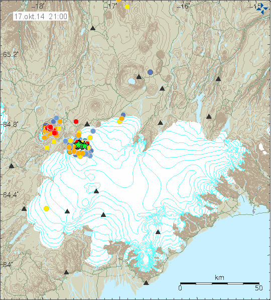
Earthquake activity today in Bárðarbunga volcano and Tungnafellsjökull volcano to the left. Copyright of this image belongs to Icelandic Met Office.
Largest earthquake today had the magnitude of 4,4. Second largest earthquake today had the magnitude of 4,2. Other earthquakes have been smaller today and there has been less earthquake activity today compared to earlier this week (Week 42). There was not big change in the eruption in Holuhraun today according to the news, the magma that did erupt today was reported to be more gas rich then in past few days or weeks. There is no major change taking place in the dyke area according to GPS measurements from the area around Bárðarbunga volcano. The GPS mesurements can be found here. New images of the eruption in Holuhraun can be found here. So far I have not read or seen anything more taking place in Bárðarbunga volcano. If everything stays quiet (I’m sure it won’t do that), I plan to have next update on Monday 20-October-2014 if no major activity takes place.
I wish everyone a good weekend.
Article updated at 23:46 UTC.
A very interesting earthquake map.
It is very different from the last few weeks as there are very few quakes N, NE of Bárðarbunga!
The question is when will the first green stars appear over Tungnafellsjökull and what will happen when they do?!
How curious! Bardarbunga EQs have slowed down in the last few days, but the EQs at Tungnafellsjokull are up in number. I do not think the hot spot under Iceland cares which volcano it erupts lava from, just as long as pressure is sent up and out. As said in this forum already, magma seeks the easiest path. It makes no difference which plate a volcano is on, if there is rifting in the MAR. No matter which side of the rift, right or left, the magma will take the easiest path.
Oh, forgot to add this idea in the previous comment. What about both or perhaps even more volcanoes all erupting at once?
I just came across this now (23:26 UTC Friday) http://www.mbl.is/english/news/2014/09/10/bardarbunga_subsidence_grave_concern/
Er. That “news” is more than a month old!
Thanks for pointing that out (I am a bit red-faced here)
My math suggest that a pressure drop might have happened in Bárðarbunga volcano magma system. This happens because an wave of magma is coming from depth. If this is math is true, a new stronger eruption might start in Bárðarbungu volcano in next few hours to days when the new magma that is coming up from depth reaches shallower levels in the crust.
My formulas that I run constantly in my head are not perfect and only based on the data that I have, so if I am missing something the outcome might be wrong.
Thanks Jon for this new insight. Hoping that things are not too out of control when the new surge reaches the surface as you have speculated. I have been watching the EQs off and on all day, and have been concerned that magma was on the move. I have often heard that before a major eruption a volcano MAY have a brief “quiet” period. Since I am not an expert, I can only guess.
I concur, dfms latest 3D graph on BB eq’s clearly shows two fissures again. The problem with these being connected to the drop in the plug is that the other two sides are missing largely.
It is reasonable then to presume that some of this activity, if not all, is actually magma rising, forcing its way up and leaving a trail of eq’s just like the holuhraun did in the early days.
https://www.youtube.com/watch?v=aAxOe4qSxRU&list=UUft1DTmR-ulbJix1SvKLL9A
Jón what was the volume in Grímsvötn 2011 km3 ?
Acc. to this IMO presentation, Grímsvötn 2011 produced about 0.15 – 025 km3 DRE and the bulk of it was emitted during the first 30 hours of the week-long eruption. Eyjafjallajökull in 2010 for comparison, produced about the same quantity of DRE in 39 days.
http://presentations.copernicus.org/EGU2012-9734_presentation.pdf
Interesting to see all the last 24hr larger Bardarbunga quakes are deeper than recently. I wonder what that signifies for the caldera subsidence.
More gas in the magma at this later stage in the eruption could mean an influx of fresher (deeper) magma that hasn’t sat in a shallow magma chamber for a period of time. Typically in the Hawaiian eruptions with which I’m familiar, the initial eruption of gas-charged magma comes from the top of the shallow magma chamber where the gas has accumulated. Then the gas-poor magma starts erupting, the high fountains die down and the flow becomes more effusive.
What’s happening now is something we don’t normally see in Hawaiian eruptions. It’ll be interesting to see if fresh magma is entering the rift that’s feeding Holuhraun.
It’s a bit the other way round of what we see here, isn’t it. In general, Hawaiian eruptions are nonexplosive with low fluid magma erupting [check]. The Holuhraun eruption is nonexplosive too [check]. Sooooo. If the initial eruption wasn’t that gas rich, what was the main driving force behind it? For gas bubbles are the main reason for magma to rise and consequently erupt. Tremendous forces were and are obvious at work.
http://www.geology.sdsu.edu/how_volcanoes_work/Controls.html
What is the zero-day exploit in this theory.
It is obvious that tremendous forces were and are at work.
The other main force initiating magma to rise is underpressure, when the rifting, i.e. opening of fissures, reduces the pressure, magma can rise and fill in the voids. This is a very big rift zone between the Northamerican and the Eurasian Plate where Bárdarbunga sits, and this is the difference to the intraplate volcanism of Hawaii. Similarities on the other side, are the hot spot and a tendency to basaltic eruptions.
Yes that’s right, I think I know what you mean, magma must be formed in the first place due to decompression melting of the
earth’s mantle.
More on the rise process ONYAT (oh no, yet another link):
http://volcanoes.usgs.gov/hazards/gas/
“The increasing volume taken up by gas bubbles makes the magma less dense than the surrounding rock, which may allow the magma to continue its upward journey. Closer to the surface, the bubbles increase in number and size so that the gas volume may exceed the melt volume in the magma, creating a magma foam.”
ONYAT = ONYAL 🙂
Where do all these typos come from.
“University of Iceland also has new map of the lava field, I just don’t know how to link to that image here.”
=====================================
Let’s see if this works :
https://pbs.twimg.com/media/B0K-Z1zIEAAf4db.jpg:large
Yup.
Sat, 18 Oct 00:11 UTC M 4.2 / 10 km – Iceland GFZ
Sat, 18 Oct 00:11:20 UTC M 4.6 / 10.3 km -125km WNW of Hofn, Iceland EMSC
64.58N 17.62W 10km deep
Suppose that Tungnafellsjökull magma reservoir has been breached, and it is now adding to the magma flow at Holuhraun? There seems to be a divided opinion here, about 1/2 insisting that Bardarbunga is draining, so why not Tungnafellsjokull too?
Others are insisting that magma is coming from a separate source, deep in the mantle, fresh, feeding Holuhraun directly.
Does anyone know? Or do we keep guessing? (like I just did 😉
Notice how there was a rather large rise in the caldera GPS station just before the most recent significant drop.
Magma entering the system?
Who said the caldera is “watertight”? Papers?
I spotted this too, and I know you have commented several times about it. If these rises were magma entering the Caldera, pushing the ice up, and then it melting it could to some degree be explained.
The only problem is the caldera is supposed to be watertight and any water would have nowhere to go so it would not show a drop.
Remember there is only one gps unit on BB and it could effectively be representing a cauldron rather than the whole Caldera. I am assuming the IMO flyovers have ruled that out though. So back to where the water is going?
See question above, 10:52.
Volcanic rock is never really watertight, it is more or less brittle.
So that some water would percolate into the rocks on the sides of the caldera. And if we are looking for where it went: Geophysicist Björn Oddson said in an interview that the water could flow into the rivers (Jökulsá á Fjöllum as well as Skjálfandafljót are big rivers) without us seeing it, because the increase in water discharge could be rather low. http://www.visir.is/seven-eruptions-in-bardarbunga-area-so-far/article/2014140919943
I know Inge, but we have been trying to find explanations for some time as to where the magma is going, even the experts have intimated that BB may not be feeding the fissure at all. It has been suggested that the magma is going into fissures in the Caldera wall, if that’s the case then water joining it would not be a good event.
Studies I have seen show there could be as many as four magma chambers, Upper, two intermediate and a very large lower one. It has been suggested elsewhere that for the caldera to subside the pressure must be low enough for it to fall beneath it.
I understand CP’s comment as to why it rises before it falls, and if the subsidence were consistent that would not happen. Up until two weeks (approx.) ago the subsidence was on a decreasing parabolic curve, the ‘average’ line has since straightened and is continuing down with these odd rises and larger falls – not all associated with large eq’s.
The caldera quakes all now seem to be very close to the surface. Again I take this as validation that there is an eruption under the ice and the subsidence of the GPS is due to ice under it melting, not the caldera itself collapsing.
Drainage of bb and reduced pressure would induce more deep magma/mantel mush to melt. The flow from depth would change the gas signature. I read though that deep magma from the MAR had less gas. More h20 would be from the glacier melt and would affect the overall chemistry. Deep magma rising, mixing with water,consuming the plug and cooling before flowing out to holraun is possible. Base line tremor is generally on the up again.
“Drainage of bb and reduced pressure would induce more deep magma/mantel mush to melt.”
It can’t drain. The bottom of the caldera is over 800 meters deep surrounded by the caldera rim. It is like a volcanic eruption almost 1km deep in the ocean. All it is doing is trying to heat the water but it can’t because every time the water warms, it melts some ice which cools it again.
To a degree I concur, however volcanoes can make short work of glaciers. Grimsfjall showed us that not too long ago.
If the eruption wasn’t inside a caldera, I would agree. If it were outside of the caldera where the melted water could just run off and form a glacial flood, sure, it would burn through the ice quickly. In this case it can’t. A pillow of lava erupts, the water warms, rises, hits ice, cools, sinks. The water can hold a LOT of heat. In the case of Grimsfjall the water just ran off into the draining system, it wasn’t an eruption inside a 800+ meter deep caldera.
It was able to burn through the ice because the melt water ran off: http://icelandgeology.net/?p=187
That can’t happen in this case.
That’s true, but take askja lake which was largely frozen, it thawed very quickly and it did not have this level of activity beneath it –
http://icelandgeology.net/?p=2406
I’m with your thinking, we differ a bit on outcomes but that’s anyones territory 🙂
Also, subglacial dome building events are rather common in volcanoes of this sort. It is a shield volcano, eventually the caldera will fill with new lava over time.
“take askja lake which was largely frozen”
This one wasn’t “largely frozen”, this one was COMPLETELY frozen to 800 meters depth. A caldera that is 800 meters deep (actually closer to 850 meters at its deepest point), frozen solid with another 85-150 meters of ice over the rim of the caldera. This is a different animal than Askja. It is going to take a long time to melt that much ice in a caldera that deep and that large (10km across).
Just watch and see. It *might* last long enough to melt all of the ice, or it might not.
Öskjuvatn water level isn’t going down anymore since 2007. It’s the deepest lake in Iceland, some 200 meters.
http://icelandreview.com/news/2012/04/06/eruption-askja-volcano-predicted
AVCC colour map wasn’t upgraded to include tunga – not even to yellow.
I find this a little odd in light of recent swarms, surely it should be raised to at least yellow. Two swarms within 48hrs with the second being somewhat significant with over 80 quakes, and continued quakes in between the swarms. Either the experts at IMO know something, or they’re being very ignorant/ arrogant.
Isn’t it rather ignorant/arrogant to make such a statement without any proof?
Are you for real? Seriously did you just ask me that, or are you on a wind up?
Proof? Read what I wrote, and then go look at the map yourself.
“the experts at IMO” do “know something”; they know Tungnafellsjökull has had only one or two possible small eruptions during the holocene.
It’ll take a hell of a lot more action that we’ve seen here to wake THAT up!
Your inference of “ignorant/ arrogant” as even a possibility when speaking of the IMO is offensive and unwarranted and says a lot more about YOU than it does about them.
Exactly.
Before insulting me, perhaps you should have considered this!!
GREEN: Volcano is in normal, non-eruptive state.
or, after a change from a higher alert level:
Volcanic activity considered to have ceased, and volcano reverted to its normal, non-eruptive state.
YELLOW: Volcano is experiencing signs of elevated unrest above known background levels.
By their very own statement above, a dormant volcano situated in an area that is currently at unrest.. A volcano which has and still is experiencing an abnormally high amount of earthquake activity should be raised to at least yellow.
So what if this volcano has only had 2 possible eruptions in the last 12,000 years. In geographical time 12,000 years is nothing.
For you to imply I am being ignorant when I state that they either A) know more then they’re are letting on or B) are being ignorant, it speaks more about you.
Ian I don’t know you, but I can tell you critiscising the IMO is not acceptable. They may well know something, but they are far from ignorant. They are working extremely hard, putting their own lives at risk up there, and with a limited budget.
Just accept what they release in information and try to understand it along with everyone else in here in a friendly manner. It is not nice seeing spats develop and I’m not taking anyones sides, just offering friendly advice.
Before criticizing the IMO, know that I was sitting down to lunch with them a month ago, discussing the evolving situation.
If you took what I said as an insult, how am I expected to react to “ignorant/ arrogant”? Pot? It’s kettle on line one..
Huge EQ there on the plots has anyone got more info on it
2014-10-18 09:40:15 5.1 64.77°N 17.44°W 10 C (Potsdam, Geofon)
Another source has it at 4.9
I was expecting one earlier to correlate to the big drop about 5am –
http://snag.gy/1aZBc.jpg
Magnitude mb 4.9
Region ICELAND
Date time 2014-10-18 09:40:13.9 UTC
Location 64.76 N ; 17.37 W
Depth 4 km
Distances 229 km E of Reykjavík, Iceland / pop: 113,906 / local time: 09:40:13.9 2014-10-18
108 km S of Akureyri / pop: 16,563 / local time: 09:40:00.0 2014-10-18
This is a temperature dependent event,the shallow magma is not very eruptible but is being heated by the large infusion of basalt from depth.This process could go on for quite a long time but if there is an eruptible point,it will be reached suddenly.Just like boiling a pot with a lid,as you watch you wonder will this ever boil and then it is overflowing onto the cook top.This heat will start to generate large scale hydrothermal activity under the ice,the ice cap will start to disintegrate without necessarily an eruption occurring for it to happen.Just my thoughts
IngeB is right. Volcanic craters and calderas are seldom watertight – and in this case BB has experienced thousands of earthquakes which will have thoroughly fractured the rocks of the volcanic edifice. Katla manages to erupt catastrophically every 50 years or so despite 200-700m of ice in its caldera:
http://en.m.wikipedia.org/wiki/Katla_volcano
Any eruption in BB doesn’t need to melt its way up through the centre of the ice plugging the caldera – just to send enough steam and hot gases up the ice-rock interface formed by the main caldera ringfault to create an outlet. I suspect that if this happens it will be on the northern rim where recent earthquakes have clustered, especially as IMO has observed the greatest surface subsidence on this side.
If the magma is able to erupt explosively,and that is still an IF.It will have no problem erupting and could just blow the rim out, an already weakened icecap would not present a problem.I will take a “guess” that a caldera eruption would be very voluminous and be a very powerful”burp” of a lot of heavy material,like a very large hotter version of the recent event in Japan.
It’s *already* thoroughly fractured; it has been forever. It has a ring fault system; that’s why it’s a caldera!
What’s happened is that the movement of magma, and the changes in the regional stress field, have caused those faults to become active and start moving, and that causes earthquakes. It’s not like you’re breaking ‘virgin’ unfractured rock.
What happens if/when it erupts depends on the intensity of the eruption. If it’s low intensity, it may produce nothing visible at the surface, or just a series of small slow-evolving cauldrons; it wouldn’t surprise me one little bit if there’s already been a few episodes of that. If it’s a powerful high-intensity eruption it’ll go through the ice like a hot knife through butter.
Upgraded to 5.4 – checked.
A 5.4 at 0.1km depth….surely that must be causing an eruption!
5.4M at 0.1km depth about 1hr ago (checked by IMO) according to 3dBulge – looks like the N caldera rim of BB, but not yet on IMO map yet. Nasty! Rapidly followed by a 4.1M at 5.1km.
Where would you find drumplots for the 5.4? The closest station
After some googling I found this link
http://hraun.vedur.is/ja/drumplot/vatnajokull.html
I am very curious as to what kind of activity could cause such a large quake at this shallow depth. It doesn’t look like an intrusion and also not a collapse since there is no subsidence. Could you see by the drumplot if this is some kind of a explosion tremor or a fault slip tremor?
We wouldn’t see the subsidence on the spot. See Dave McGarvie, @subglacial (tweets), 8. Okt.: “If you are wondering why Bárðarbunga caldera collapse appears so regular on the graphs shown on en.vedur … .is , consider that the GPS station is actually measuring ice movement. And that this is buffered by the ductile deformation of a huge mass of ice. A 1 km2 caldera block suddenly dropping 1 m would be registered a few days later as “background” subsidence by ice-surface GPS.”
This is also the reason why Dave McGarvie meant at some other occasion that it does not give a lot to always compare the GPS movements shown on the graph with the earthquakes (seemingly) happening at the same time. As I understood his explanation, we wouldn’t as laymen find out the movement really happening at the same time as the quake.
Dave McGarvie is a specialist on subglacial eruptions.
@IngeB since I for some reason cant respond to your answer I respond to myself.
Since the ice above the caldera is of such height I see how we can compare it to how a glacier moves downwards like a slow flowing river. Still on almost all 5+ earthquakes there has been a 10-30cm almost instant drop so I would expect to see the same for this 5.4 quake, also since it happened in the same area as most others.
The heating of the chamber is causing the caldera deformation and the earthquakes are a side effect of this heating.The ice drops correlated to quakes are just the ice settling in response to the quakes,maybe as more meltwater builds up in the base of the glacier ,this acts as a shock absorber for the energy from the quakes so quake/ice drop correlation is less apparent?
Ice is always on the move, the bottom of the caldera is not smooth, but there will be hollows and ridges and now there are all these movements (normal faulting?) on the caldera rim, in the middle there will be an indentation, and also geothermal heat (reps. perhaps small subglacial effusive eruptions) will build caves or new ridges, all that will make this mass of ice move around.
See eg. https://en.wikipedia.org/wiki/Glacier
1. 12,000 years means it’s an old, cold volcano.
2. We refer to ‘geological time’.
3. Swarms, primarily tectonic in nature, are fairly common in this area.
4. Read the damn paper: http://skemman.is/stream/get/1946/11137/27366/1/The_Fissure_Swarm_of_Tungnafellsjokull.pdf
5. Shut up.
Mike don’t even bother arguing .With some people the potential of a large caldera eruption does not register.They have no concept of what a caldera event would entail.IMO have to base what they say on most likely scenarios as peoples well being is dependent on their warnings.If an explosive caldera event becomes that likely scenario then they would alter their warnings accordingly,now is not the time to chase after a Tunga rainbow.
Sorry that’s a misplaced reply to Ian’s ‘GREEN / YELLOW’ post above.
The other point I will make is Bardarbunga could be just a system evolving into a higher state of activity,in this case it could grumble away for years and this might trigger activity in other systems and itself be a constant concern requiring expensive ongoing monitoring into the future.
While there is increased risk of eruption in Tungnafellsjökull volcano it is far off from erupting at current stage.
Perhaps we need to emplace some seismos and GPS in here, as there’s some indication that brennevin may be starting to rise in the rift system.
LOL. Some truth in that.
Damn. I expect to be filming in Hawai’i soonish, due to Kilauea lava being close to entering the town of Pahoa. Now you’ve really put me in the mood for a loco moco… there’s a little restaurant in Kalapana does a great one!
When I started using this handle, a Spanish speaker informed me it means “crazy snot”. Well, that’s not far off actually.
I have been away for a while (in Belgium) and have just been catching up on everything.
From Rei at DailyKos she referenced a report (see link below 11th October) about observations of many small ice cauldrons around the rim of the caldera seen from a fly over.
http://www.ruv.is/frett/engin-merki-um-ad-gosinu-se-ad-ljuka
Is this what you are referring to here with regard to the water thermal activity?
Please excuse my confusion, it maybe has been said before and I have missed it. Thank you.
Yes, that would be an explanation for the formations of the small ice cauldrons. They always indicate additionnal heat input into the system.
Another possibility is heightened geothermal activity at the caldera bottom.
Sorry- the link to the report by Rei I mentioned above is in her diary here:
http://www.dailykos.com/story/2014/10/11/1335972/-B-r-arbunga-Who-s-Watching-The-Watchers-A-Fox-Named-Gosi
Bárðarbunga….and now “Goðabunga” ?? Cowabunga !!
All the Eq activity is on BB … Kistufell has been erased on the eqs table from IMO .
5.4 at 0.1km deep !!!
Revised & confirmed.
I’ve a question… Is this deep 100m above the caldera? o 100m down ?
Where is the messure point ? The bottom of the glacier ? or the same cauldron ?
I was thinking the same thing Raul, perhaps someone has the answer!
The depth of an eq can be relative to mean sea-level or the average elevation of the seismic stations that are used, I think it depends on the method used to locate the earthquake.
I am just a lay person but this question has arisen before. I believe the answer given then was that the zero point was mean sea level.
Whilst on the subject of earthquake position can anyone explain what error bars should be attached to the given results? I presume if depth is quoted to nearest km then the error would be +/- 0.5km and simmerly with latitude & longitude.
And wich method is used by IMO ?
I don’t know but I am sure there are others on here who will know the answer
IMO says they indicate the focal depth, ie. distance from epicentre (on the earth’s surface) to the hypocentre (within the crust directly under the epicentre): http://en.vedur.is/earthquakes-and-volcanism/articles/nr/1225 (Earthquake table). See also on focal depth: http://earthquake.usgs.gov/learn/glossary/?term=focal%20depth
Some more material on locating earthquake locations (by IRIS):
http://www.iris.edu/hq/files/programs/education_and_outreach/aotm/interactive/HowAreEQsLocated.pdf
Ehm … locating earthquakes …
thanks @IngeB – so the measurement is from the origin of the earthquake to the earths surface directly above. So we are having quite large earthquakes very near the surface.
Would be a rather big bump, if it is correct. But I still would wait til Monday, when other people will for sure check after on this one. Data were sometimes revised afterwards.
ok thanks 🙂
Someone claimed that 0.1 is used to signify that the depth could not be determined.
Is not 1.1 km IMO’s default depth, when they don’t know yet? Here eg. are a lot of them: http://www.vedur.is/skjalftar-og-eldgos/jardskjalftar/vatnajokull/#view=table
Good question eigelijk.dat saves 1700 meters.
Concerning Tungnafellsjokull:
Mike, although I agree that usually takes a lot to wake up such a long volcano, and I do agree with you on this, we have seen exceptions.
The westman islands Heymae volcano erupted in 1973 with relatively little warning, after 5000 years of dormant period, catching the local people by surprise.
While they probably had seismic detectors that time but much less sensitive than nowadays, I think people would feel any larger quakes, like M3 especially when you live in the future site of eruption (the fissure opened in the middle ofg the town). It makes you think no?
I think Tungnafellsjokull is clearly reacting to the rifting around it. This is not a surprise. But we have seen some deep earthquakes at a spot NE of it, a few months ago. This makes me pay that this volcano could be our next unexpected volcano to erupt. But I don’t expect an eruption in a new volcano every 3 months, that’s breaking the statistics/history of Iceland. I expect more an eruption in a different volcano perhaps every 3-5 years, and some of them large and related to rifting.
In the next 15 years I expect at least 3 eruptions in Vatnajokull, and not all of them from Grimsvotn. My guesses go for Thordarhyma, Bardarbunga caldera, Hamarinn, Kverfjoll and Tungnafellsjokull as the most likely ones. That’s how Icelandic history goes in periods of high activity. But I agree that we should see a lot of noise (earthquakes swarms, GPS movements, tremor, etc) before they go. Just like Holuhraun did.
Ian: please don’t call arrogant to the IMO or saying “they know something”, they are probably the most open to public geology service I have heard of. They are pretty straight to the point, pretty open, and pretty easy to talk to.
They don’t hide anything, to the best of my knowledge. They are giving the Icelandic public updates nearly every day, in a calm cool way. Their data is mostly online and free access. GPS, real time earthquakes, local scientists in the area, tremor detectors, papers, daily news, etc. Do you think that’s being arrogant or hiding information?
I only point a critical improvement necessary for the IMO, which is the apparent lack of earthquake detectors in Snaefellsnes. Other than that, they have all Icelandic volcanoes very well under watch.
PS: finally last 2-3 days have been without any SO2 haze (levels above 300-500 ug/m3). This is good time to ventillate the house freely, especially with the passing gale. But the winter and northern winds are coming to Iceland next week.
Irpsit you are one of the few on here that I look for posts by, I enjoy reading them, one of the few who seem to make sense, and are capable of making rational logical intellectual debate/ theories… unlike the other 2 that I’ve unfortunately found myself in a spat with today.
All this was for something simple enough to understand, but for whatever reason was taken out of context, either deliberately to feed the ego of “keyboard warriors” or through a lack of basic comprehensive skills.
Please read my original comment. It was regarding the aviation colour code, there is a volcano showing signs of unusual activity yet there was no upgrade what so ever.. It is not unreasonable for a non scientist/ member of the public to question why there was no upgrade, after all it is they themselves that state yellow for unrest. I can only draw up my own conclusions to why they’ve not upgraded it to yellow… Either they know stuff that’s not been released, or they are just being complacent because this is a volcano that hasn’t erupted for millennia. If the latter was sadly true then it would be reasonable to state they had been ignorant/ arrogant.
At no point did I make the bold statement that they are ignorant/ arrogant.
I think re. IMO, you are absolutely right here, Irpsit. 🙂
Also re. Snæfellsnes, there are anyway 3 active volcanic systems in this area. BTW there you would also find the approval of Haraldur Sigurdsson, who is since a long time trying to get a fast seismologic station on the pensinsula http://vulkan.blog.is/blog/vulkan/category/2660/?offset=20 . I read on his blog a discussion with other Icelandic geologists who mentioned it would be a problem of financing that. http://vulkan.blog.is/blog/vulkan/entry/1255032/#comments
There were some students there from Germany for some time doing field work on Snæfellsjökull and they detected some quakes, the volcano is just sleeping, not extinct.
And good for you, to have good air to breathe for a change, hopefully, this eruption comes now very soon to a (peaceful!) end.
Often wondered why there were no seismologic stations at Snæfellsnes.
You are not alone. 🙂
IMO is great but I wish they’d provide more downloadable data sets. Maybe they do in a context I don’t know about — but that’s my one complaint.
Is something like that what you are looking for?
Icel. IMO (Veðurstofa Íslands)-> Jarðhræringar ->Jarðskjálftaryfirlit -> Vikuyfirlit -> Skjálftalisti
eg. http://hraun.vedur.is/ja/viku/sidasta/listi
Nice! Thanks!
“Mike, although I agree that usually takes a lot to wake up such a long volcano, and I do agree with you on this, we have seen exceptions.”
There was recently an article at Erik Klemetti’s blog that new research has indicated that a volcano can erupt very quickly after an injection of new material, contrary to previous thinking.
This text here talks about a magma ascent with a velocity of about 10 km/h (8,5- 36 m/sec). http://www.sciencedirect.com/science/article/pii/S0377027312002314
On the other hand, Hekla is said to have a magma chamber at about 8 km depth, and the magma ascent from there took just 30 min. in 2000, which would be much faster, around 16 km/h.
And here is a new paper (abstract) on magma injection and buoyancy. http://www.nature.com/ngeo/journal/v7/n2/abs/ngeo2041.html
On Hekla’s 2000 eruption:
– Univ. of Iceland, Earth Science Inst. http://earthice.hi.is/hekla_eruption_2000
– a scientific paper:http://www.geo.mtu.edu/~raman/papers/Heklawhole.pdf
Mike, great paper.
http://skemman.is/stream/get/1946/11137/27366/1/The_Fissure_Swarm_of_Tungnafellsjokull.pdf
I will give a summary of this paper that studies Tungnafellsjokull:
– a relative inactive system in the Holocene. Only two small lava flows since ice age.
– fissure swarm 40km long (central volcano covered by ice cap and evidence of smaller eruptions north and south of it)
– located in tripple junction of European, American and Hreppar plates.
– recent movements were detected in the volcanic system, indicating more activity than previously thought
– the revent movements occurred in 1996 during Gjálp eruption, August 2008 and November 2009. They are associated with increase earthquake activity in Tungnafellsjokull.
– i add that the spot where the recent movements were detected in those years, are the same of last days’ activity. They are NW, N and NE edge of central volcano
– some authors consider 2 or 3 central volcanoes: Tungnafellsjokull (10km wide mountain), Vonarskard just 5km to the SE (which is a 8km wide ice-free caldera) and Hagongu to the SW (just a tall mountain but doesn’t look much of a well established central volcano to me)
– the Vonarskard central volcano is the one that shows most recent activity, has a large geothermal field, the two Holocene small lava fields nearby but not within the caldera: Dvergar and Tunguhraun. The fissures are difficult to trace back to the central volcano due to much erosion in the area (glaciers, water).
– These recent vents are located N of Vonarskard, NE of Tungnafellsjokull, near the spot of most earthquake activity in recent days. They are really small eruption vents, so indicate that those two eruptions were small.
I should also add that 1996-2011 period saw about 50 earthquakes in Tungafellsjokull volcanic system (source paper above).
In the last 2 days there has been 70 earthquakes in the volcano (source IMO). So this is clearly a sign of increasing activity there. And a clear one.
The same thing happened with Bardarbunga in 16th August. Suddently in 48 hours it had more earthquakes than in the past few years.
I am not saying that it will erupt, (and if it does, it will be probably a small eruption), but I just say that we should be open for the good possibility of seeing new non-eruptive rifting fissures open (like it occurred in Dyngjojokull) and then there might be a change for some small lava eruption later there.
Have you considered that the Holuhraun fissure field and Tunga are “safety relief valves”for Bardarbunga,the fissure field “valve” has failed and so more load is being shifted to the Tunga.. “valve”,but the latter is possibly of little use as the stress is now too great?
Some points on this:
– there were acc. to the paper also movements in the SW of Tungnafellsjökull (Ógöngur area);
– re. the movements during 1996, this is as well as the Gjálp eruption, just part of the rifting and rift jump process we are seeing in action at the moment;
– Hágöngur volcanic system (if seen as an independent one) consists of 2 taller mountains. http://www.panoramio.com/photo/28629336 There is btw. a big reservoir there (37 km2) to which in 2011 a small eruption in northwestern Vatnajökull (probably Hamarinn) added around 6 m of water height.
What I found interesting in this a.m. paper is that the fissure swarm of Tungnafellsjökull does not fit in usual patterns of Icelandic fissures swarms. It is not elongated with a central volcano in the middle, but the fissures extend mostly to the sides, E and W of the volcano. This is also why the authors think this system is not part of Eastern or Northern Volcanic Zones, but of the Central Iceland Volcanic Zone (sometimes it is also called MIB / Mid Iceland Belt).
I think also there are good arguments to see Vonarskard as a 2nd caldera of Trungnafellsjökull volcanic system, like the authors do.
Well put, geyser soze. Paper mentions tunga’s fissure swarm doesn’t appear to radiate from it, but travel through it. Seems logical to me it’s part of barda’s fissure system.
Maybe it makes most sense to consider tunga as a flank volcano of barda?
It is possible that Tunga has post Barda caldera eruption extrusive degassed magma flows ,rhyolite and basalt?
There are rhyolitic lava flows at Tungnafellsjökull (more than 10.000 years old). I don’t think that the age of the caldera at Bárdarbunga is known, but Tungnafellsjökull seems to be the older volcanic system (Pleistocene age). The Holocene lava flows at Tungnafellsjökull anyway are basalt.
I also found this paper about the Vonarskard caldera rather interesting:
http://www.geothermal-energy.org/pdf/IGAstandard/WGC/2005/0640.pdf
I think someone here or on VC might have commented that Bardarbunga was 8 million years old?I dont know validity of that information,but Barda could have easily erupted 10000 yrs ago and caused effusive rhyolite to erupt at Tunga?If it causes activity at Tunga ,then this event would be larger than any event in this system in recorded history?
Bárðarbunga is one of the few Icelandic volcanoes which are more or less notorious in causing twin eruptions in neighbouring systems.
She did it not only once with Torfajökull, since settlement twice (Vatnaöldur, ca. 900, and Veidivötn, around 1480), and I don’t know how many times before. See eg. http://www.dmg-home.de/Abstracts/Koeln2007/Goldschmidt2007%20%28E%29/program/abstracts/A1153.pdf
See also A. Gumdunsson etal., Mechanical interaction between active volcanoes in Iceland. http://onlinelibrary.wiley.com/doi/10.1029/2007GL029873/full
Re. age of Bárðarbunga: I don’t believe that the volcano is 8 mill. years old, because at that time, the rift zone we observe now was not yet active. Till around 7 mill. years, the active rift was positioned over Snæfellsnes and into the north up to Vatnsnes, as far as I know. The rift jump began just then with activation of the Western Volcanic Zone. And I am not sure, if the now so active Eastern Volcanic Zone was not still later beginning its activity, could also be that it was a so-called “propagating rift” at the time (ie. a rift zone in the making). This is all, because the whole rift is wandering slowly over the hot spot in western direction so that the rift has to move east in order to attune its position to the hot spot.
In the Tungnafellsjökull Paper (pdf, p.4) is mentioned that Bárdarbunga and Tungnafellsjökull are separate systems. And that Bárdarbunga is younger than the latter. GVP mentions eruptions dating back just 8.000 years, but this may just be because this is the period of the history of Icelandic eruptions that is better researched up to now.
8 million years was from VC,so enough said about lol.I cannot see any reason that an edifice like Bardarbunga could not be at least 10000 years old,maybe it was Tungas offspring and now it has taken the role of mother?
Thank you Inge 🙂 It is all fascinating information.
Just 6.15pm there appears to have been a harmonic tremor lasting 15 minutes… Unless I’m reading it wrong.
It wasn’t picked up from what I see on the other stations.
How very strange… Upon refreshing it has disappeared :/
Don’t know if I’m reading it wrong but the caldera drop graft on 3Dbulge has dropped about 10cm in as many minutes, it seems to be going straight down.
Forget it It just went straight back up.
There is a storm in Vatnajökull area at the moment. There is going to snow storm in Iceland on Monday.
Anyone know the IRIS 3D . . . rotatable . . . imaging link?
I seem to have misplaced it.
OK, this is the route to that page:
http://www.iris.edu/ieb/index.html?format=text&nodata=404&starttime=1970-01-01&endtime=2025-01-01&minmag=0&maxmag=10&mindepth=0&maxdepth=900&orderby=time-desc&limit=200&maxlat=85.37&minlat=-85.37&maxlon=180.00&minlon=-180.00&zm=1&mt=ter
http://en.vedur.is/earthquakes-and-volcanism/articles/nr/2971
Here it is the link.
And here’s the result when using the “shift” key & cursor to outline a rectangle for 3D depiction on Iceland:
http://www.iris.edu/3dv/index.html?caller=IEB&st=1970-01-01&et=2025-01-01&nma=0&xma=10&nde=0&xde=900&ob=time-desc&li=4000&xla=73.628&nla=51.609&xlo=2.123&nlo=-35.156&sbl=1&pbl=1&zm=1&mt=ter&sz=med
Looking at the 3D image of Iceland . . . compared to the sphere of earth . . . virtually ALL the quakes under Iceland have been fairly ‘shallow’ comparatively.
IIRC, I’ve only found 2 spots (there are probably more but that’s all my curiosity has found) where REALLY DEEP quakes are depicted . . . the area of the Sumatra devastation a few years ago . . . and near Mt Etna in Italy.
Therefore what, I don’t know.
But I was expecting to see more deeper quakes as there have been some quakes in Iceland which were characterized as quite deep–and they were quite deep compared to most of them. However, on such a 3D image, they are still RELATIVELY shallow.
I had assumed that given the hot-spot . . . and the MAR . . . and the recent activity that the 3D image would show some deeper quakes. NOPE. Interesting.
The IRIS image is interesting, but for locations (incl. depth) I would rely on the Icelanders (IMO).
Thanks for your kind reply.
imho,
Of course the IMO Icelanders are likely to be quite accurate about the depth issues on their turf, under their turf!
Nevertheless, IRIS is a highly professional outfit, too. I doubt they are significantly inaccurate, very often.
I think that one primary reason the quakes on the IRIS 3D image appear so shallow . . . is that they are depicted on the rather large curvature of the sphere of planet earth. Perhaps we could call it an issue of scale.
Yet, the Sumatra and Etna quake areas show quakes, even on the IRIS 3D imager, that are VERY deep–and look it. I don’t know the relative km differences. I’m sure they are significant.
I’m just surprised
1. That so few areas on the planet have such very deep quakes as those at Sumatra and Etna.
and
2. That the hot-spot and MAR dynamics under Iceland do not include comparably deep quakes on a par with those of Sumatra and Etna.
I don’t know therefore what–by any means!
It’s just a curiosity to me that I wanted to share in case any professionals or well studied laymen would have an educated comment to enlighten me with.
I don’t doubt that the IMO experts et al discussing lava coming from very deep sources are quite accurate. It just APPEARS that in terms of the quakes involved, the quakes at Sumatra and Etna are MUCH DEEPER still.
That’s odd, to me.
The caldera in Bárðarbunga volcano drops 40cm/day mostly without large earthquakes. When earthquakes do happen it drops even more. This is according to this news here.
http://www.mbl.is/frettir/innlent/2014/10/18/askjan_sigur_um_40_cm_a_dag/ (text is in Icelandic)
The interviewed scientist, Kristín Jónsdóttir (IMO), also says that they don’t think at the moment that an eruption is started in Bárðarbunga. There would be harmonic tremor to be seen, which is not the case now.
Sorry if I posted the wrong link.
I think that volcanoes do not pose more danger than a new volcano, current magna rooms can also choose another way upwards.
eigelijk is an old volcano a result of an ancient road of least resistance. The corpse me better to find out where the new output coming from and what mixture of raw materials through the lava comes. and what it will do
it seems like a new eruption is found closer to the source than it would perhaps. inpact more than the current which 40 km away.
Hi Andre C, not sure I understand what you are saying. Would it be possible for you to repeat it in Dutch? Please?
I don’t know, if this has been mentioned: Kristín Jónsdóttir (IMO) said in an interview with Mbl, that there is a theory by scientists that movements at the ring dyke around the caldera would enable water to infiltrate the fissures and this water infiltration would then cause the earthquakes (in Icelandic: “vísindamenn séu að velta því fyrir sér hvort hreyfingar á hringsprungu í öskjunni greiði aðgang vatns inn í sprungurnar sem aftur örvi skjálftavirkni.”). Could this mean a lot of bigger and smaller phreatic explosions are happening at the moment within the volcanic edifice? http://www.mbl.is/frettir/innlent/2014/10/17/adeins_halfdraettingur/ The scientists are at the moment checking again on the material that has been collected up to now.
My opinion is the would be plenty of heat and water interaction going on,whether it would be anything explosive,hard to say, although you would think there would some seismic evidence.Maybe they are trying to connect some of the smaller quakes to this activity?
I guess the glacier is fracking the caldera floor?