
Bárðarbunga volcano eruption in Holuhraun did reach one big milestone today (17-October-2014). It is now the largest eruption in Iceland since the eruption in Laki (Skaftáreldar) in 1783 – 1784 eruption. By volume the lava field in Holuhraun is now larger than the 1947 eruption in Hekla volcano that is 0,8 km³ by volume and took 13 months to erupt that amount of lava. Current size of the lava field in Holuhraun is larger then 59 square kilometres (km²) in size, or around 0,83 km³ by volume according to University of Iceland Tweet on this matter. University of Iceland also has new map of the lava field, I just don’t know how to link to that image here.
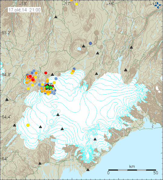
Earthquake activity today in Bárðarbunga volcano and Tungnafellsjökull volcano to the left. Copyright of this image belongs to Icelandic Met Office.
Largest earthquake today had the magnitude of 4,4. Second largest earthquake today had the magnitude of 4,2. Other earthquakes have been smaller today and there has been less earthquake activity today compared to earlier this week (Week 42). There was not big change in the eruption in Holuhraun today according to the news, the magma that did erupt today was reported to be more gas rich then in past few days or weeks. There is no major change taking place in the dyke area according to GPS measurements from the area around Bárðarbunga volcano. The GPS mesurements can be found here. New images of the eruption in Holuhraun can be found here. So far I have not read or seen anything more taking place in Bárðarbunga volcano. If everything stays quiet (I’m sure it won’t do that), I plan to have next update on Monday 20-October-2014 if no major activity takes place.
I wish everyone a good weekend.
Article updated at 23:46 UTC.
Continued great work as always Jon.
Been great being able to see the cams a bit today, botherwise 1 and 2.
Been a long time since ATS for me, but Muzzle is one of the most scientific, theory busting, nonsense hater, and sound mind on that site. Pure hard work and study, plus his location, Muzzle and Peterman are to earthquakes what Jon is to volcanos…experts.
Peace and love
Rrrr…Hate autocorrect. Muzzy and Puterman.
Mila Bardarbunga Cam 2 is beautiful atm. The lava river is very impressive.
Bb doesnt care who is what. Tiresom egotistical sensationalist unfocussed rubbish belongs to other sites.
I must visit those other sites!Oh I forgot they banned me already!
Don’t be so touchy.
Date & time: Mon, 20 Oct 05:21:26 UTC
Magnitude: 4.0
Depth: 10.0 km
Epicenter latitude / longitude: 64.68°N / 17.73°W [Map]
Nearest volcano: Bardarbunga (11 km)
Primary data source: GFZ
Hello its Gilda thought I would just comment while it is quite, I have been here all along since August but do not say much as I do not know much, but I know much more now than I ever did it is very fascinating and I check all day and twice during the night . Anyways keep up the good work Jon hope you have a good return to Iceland and carry on enjoying everyone it is a great blog xx
What is the warning on the IMO in iceland translated to english.
WarningLava lava in the hole.
The storm warning?
You can always go to the English version (link on top of page).
Ignore its just a warning for the fissure just alarmed me
Seems to be a lot of earthquakes at bb area this morning at 1.1km depth. Does that mean anything significant?
Well they’ve finally done their sums:
20.10.2014 01:00:23 64.612 -17.431 8.3 km 4.8 99.0 5.6 km SE of Bárðarbunga
That ‘Kistufell’ quake at 01.00 WAS given a spurious initial location.
These quakes are not of urgent consequence,because they have become part of the volcanoes current behaviour,the key is to watch for an unstable deviance from the pattern,not necessarily what might be expected in a more conventional pre eruptive situation.
I think this is not a “more conventional pre eruptive situation”. But I think, I get what you mean. Could that perhaps be other sequences of big numbers of small earthquakes, or some even bigger ones (6+) or so? Or tremor going suddenly up again? Earthquake swarms at different locations? Big earthquakes at different locations? Or suddenly rising conductivity in the rivers around Bárdarbunga? Should show up esp. in Jökulsá á Fjöllum and Skjálfandafljót. Or small jökulhlaup in series coming down these rivers? (It is possible to check on the rivers via IMO “Hydrology” (Vatnafar) -> go to a river on the interactive map -> click on the symbol -> allow, and you have the lists on your left.)
Re. earthquakes and tremor: Will be a bit difficult to see smaller differences today and tomorrow, because of the storm.
Anything that deviates from the current pattern.Increasing numbers of quakes,tremors,gas output,glacial melt.I said it was not conventional(if there is such a thing as a conventional eruption)It is like getting a new dog,you have found out he barks a lot ,but does that make him aggressive ,no,after a period of observation you look for other aspects of behaviour that are unusual even for the new unfamiliar dog.
🙂
There was btw. a strange tremor spike today. http://hraun.vedur.is/ja/vatnajokulsvoktun/von1_trem.gif
There were one magn. 5+ quake and 3 others over magn. 4 today. But geologist Martin Hensch (IMO) said during an interview with RÚV that they would not be clues for more tectonic/volcanic movements. Kristín Jónsdóttir (also IMO) said, that the energy output of the quakes is exceptionnal. The earthquakes would be happening at the same time as the subsidence of the caldera and the most probable reason for that would be magma entering the system and leaving the central volcano in direction of the Holuhraun intrusion.
The new lava at Holuhraun btw. is now measuring more than 60 km2. http://www.ruv.is/frett/hraunid-ordid-60-ferkilometrar
I guess they have their new “dog” all figured out,so its a waiting game to see if the “dog”does what they think its going to do.That is reassuring.
I think on the other hand, that they have a handful of possible reactions of the “dog” anticipated.
They won’t just concentrate on one possibility in this situation, but more have big interactive whiteboards with decision tree models, “if …. then …”. 🙂
3 possibilites mentioned in the “stone tablets” + “Other scenarios cannot be excluded.” (IMO)
If the “dog”decides to bite ,it will be fast and possibly at an unpredictable and unexpected time.
An Hekla quake just occurred. M1.
On its own it means nothing. But if a sequence of 4 or 5 quakes starts in the next two hours, then we know we are into something.
The HAU tremor plot jumped yesterday as well.
We had these “false alarms” not only once re. Hekla. Would just become interesting when all three or more stations in the vicinity would “jump” or produce series of smaller quakes.
Can anyone tell me which station is the one in pink that is currently quite active – just numbers instead of usual 3 letter code.
http://i.imgur.com/ZhcEqiU.png
I don´t know which one it is, can you post a link to this site?
Seems to be a new instrument for DYN ?
The former were having dropout problems after larg eq’s.
The station code is programmed into the instrument and are not really needed.
This one is probably showing batch No-Ser. No.
Just my guess.
Could you perhaps explain what “batch No-Ser” is?
I think Jobbi means batch number and serial number assigned to the instrument by the manufacturer
One of the instruments that the Cambridge team put in place, perhaps?
Sorry, it’s Digitizer #-Sensor#
The old one was Cambridge/seisUK, I think.
The new one might be the same, even BGS
ask,dyn and von were Cambridge instruments and IMO power / communication.
I think it’s a joke
otherwise he would have immediately given a source
The findings made structure looks very different. It seems like one from another country comes from.
see http://hraun.vedur.is/ja/drumplot/dyn.png?id=1410201517
It is not a joke – from a page of composites on IMO site and I was deliberate in not posting the link.
you could give a hint how to google the site
I think BB_Gone is referring to a critically important IMO server that must not be overloaded and to which the general public therefore don’t have access. (By which I do not mean to provide succour to conspiracy theorists.)
BB looks unhappy today, lots of activity and just now another strong quake…
Two magnitude 4,0+ and several magnitude 3,0 earthquakes just now happened in Bárðarbunga volcano.
I just noticed this Jon, what could this mean ? magma or more sinking.
Interesting spike here: http://hraun.vedur.is/ja/vatnajokulsvoktun/von1_trem.gif
Look at what it did to the GPS station. 2m up?
Looks like a big burp
http://www.vedur.is/photos/volcanoes/barc_gps_3d_is.png
Screenshot.
http://i62.tinypic.com/243px6s.jpg
There were enough big enough quakes in the 11 minute filtering window for those plots, to push up the median value to a high level, and thus produce the spikes.
Huge spikes in tremor plots of dyn and von! http://icelanderuptions.com/
In grim station too!
I would imagine that after more than 50 very powerful EQs, not to count the smaller ones, BB should be just a pile of rubble and ice by now.
I guess nobody truly understands the mechanics at work here, at least not yet. Does anybody here know of a similar behavior in any volcano in the past?
Triple whammy.
Monday
20.10.2014 13:31:06 64.659 -17.376 0.2 km 4.7 99.0 7.5 km ENE of Bárðarbunga
Monday
20.10.2014 13:30:17 64.666 -17.399 3.2 km 4.1 99.0 6.8 km ENE of Bárðarbunga
Monday
20.10.2014 13:27:57 64.671 -17.450 3.2 km 4.6 99.0 5.0 km NE of Bárðarbunga
IMO finally catching up and putting data on their website. Is there any other site I can see eq reports as they actually occur? Prefrrably Without needing to do m y own interpretation. I’m just a very interested layperson I don’t understand the full mechanics of techtonics and eruptions
you can see the drum plots as the EQs occur
http://hraun.vedur.is/ja/drumplot/vatnajokull.html
“IMO finally catching up” Hmm, I think they have different priorities now. They can see that big EQs are occurring but they are more concerned about interpreting them in relation to the bigger picture than using valuable (and doubtless near exhausted) man-power to put them on their seismicity website.
I think you are correct.
The question is ,are they applying the data and observation to the correct model?If the model is not right then data cannot be interpreted correctly?
See my comment 23:30.
Thanks Kolla….not really sure how to read them properly though. Seems like bb is very busy shaking this afternoon…
Every line covers 15 minutes, so it´s easy to see accurate time.
VON and DYN are closest to BB.
The tremor in the Grimsfjall plot was the highest since August 16!!
http://hraun.vedur.is/ja/vatnajokulsvoktun/grf_trem.gif
I think Big B is up to something nasty! A few days ago we had the quiet before the storm. (Yes, I know that there is a bad weather related storm going on? Not what I had in mind ,however.) Jon you said that there was magma on the move up from greater depth, and I am thinking that once again your ideas maybe correct. Hope this activity proves to be mild!
Not sure how this volcano is hold up under all this shaking!
There aren’t too many volcanoes with 800 meters if ice inside the caldera where the water can’t escape when it melts. I still believe we are seeing dome building going on inside the caldera. The water inside that caldera is going to remain pretty close to 0 C as long as there is ice to melt.
In a volcano which in surplus has gone through such an unprecedented series of heavy earthquakes there are lots of possiblities for water to escape through fissures in the walls and the perhaps the bottom, too.
“and perhaps in the bottom”
Oh I see now :). Thanks for your help kolla.
Just checked web cam #1 and the visibility at the eruption is very poor (snow or fog?).
Is there not a storm blowing through Iceland again? i.e Tremor plots are pretty meaningless?
edit – Jon, please change the captcha back to numbers! These words are hopeless! On my 5th one now and I still don’t know what the words are!!! (9th actually!)
I don’t control what captcha shows you. If you register and log in you don’t have to deal with captcha puzzle.
Or if you choose not to join you could click the refresh button on captcha to get a new challenge!
Grimsfall Webcams stop working with the EQs. Last image from 13:20 (UTC)
http://vefmyndavelar.mogt.is/
Any information about?
Infrasound picked up right after the bigger swarm around 13.45 UTC.
Maybe the coincidence is by chance with the beginning of the storm that IMO is forecasting.
http://lgs.geo.unifi.it/iceland/ice3.php
We will see. As always.
Please note that I am working on setting my FreeBSD server up again. Since that is the only Os that I can properly run my Minecraft server on. That means the update for today is going to be little late, but not too late I hope.
Any screenshots of your MC, Jon?
Andrew I wasn’t digging at IMO at all, I understand where priorities lie etc. As that was the only site I could view eq. Reports on I was getting frustrated hearing about eq that had occurred and I couldn’t see them statistically.
Ah, OK. Apologies for misunderstanding you. This is useful for raw data: http://hraun.vedur.is/ja/drumplot/vatnajokull.html. Rough inferences can be made of EQ magnitude and location.
Thanks for replies up thread. I stumbled across the page when looking at the data indexes on IMO site. It has a collage of real time data from their screens and I guess it is not appropriate to publish the whole page.
Has anybody an explanation for the big jump on the GPS plot? Same time as the eqs – coincidence?
I don´t think anyone knows.
It is too suspicious the coincidence of such a jump with the eqs. Maybe a subglacial phreatic explosion, which made the glacier above to rise and fall some 1.5 m?
Or maybe the jump caused a momentary glitch in the signal?
Could a phreatic explosion have occured this morning in Bardarbunga when that huge spike on the tremor charts took place?
There was an M4.7 registered at only 200 meters depth. This occurred at the same time the large spike occurred.
There will be no phreatic explosions as the caldera floor is too deep under water and ice. It will look like an eruption under a kilometer of ocean, probably extrusion of pillow lava.
Have you considered Gjálp?
Gjálp eruption in 1996 started with the eruption of pillow lava, if I remember that right, yes. And it took the eruption no more than 30 hours to get through around 650 m of ice which were on top of it.
But if there were an eruption (ongoing/starting), IMO would see it on their tremor charts.
On the other hand, this spike was really a bit strange…
http://hraun.vedur.is/ja/vatnajokulsvoktun/von1_trem.gif
And was not the magn. 4.7 earthquake around 14:00 on the northeastern caldera rim, where the ice cover would be much thinner? http://hraun.vedur.is/ja/Bardarb/bbbeginman24h/images.html#
Could this not have been a big rock fall event? Because on the other hand, had this been a bigger explosion, would this not have initiated an eruption and following tremor spikes?
I am looking forward to your update tonight, what you make of the latest developments.
It was good to get to see eruption last night, and looks like cam 1 might clear up enough to get some view time in tonight. We’ll see I guess. Eruption just continues on like the Energizer bunny. Wonder when Big B is gonna show surface activity? Something going on under the ice. With all those quakes continuing to rattle the caldera, something has to happen soon. Of course, been thinking like that for some time now. Unfortunately, viewing is so sporadic, we really won’t be able to see much when it does. My prayers continue for you Icelanders. With having to deal with the gas emissions, and the continued threat of something major happening in your backyard, that has to be a bit unnerving, especially with winter starting to settle in.
Map from the Icelandic Almannavarnir website re. possible glacier runs (jökulhlaup) with 25.000 m3/sec. from Dyngjujökull: http://avd.is/is/wp-content/uploads/2014/10/Jokulhlaup_kort_Holuhraun_20141017.png
It would take the water 90 min. from the glacier terminus to Vaðalda, 210 til Herðubreið.
They say also that it is possible to enter the Danger area (Haettusvaeði), but a lot of precautions have to be taken, gas masks, informations gotten before and it still is very dangerous as the name says, because an eruption in the glacier – Dyngjujökull or Bárdarbunga might start without any warning time, it would perhaps not be possible to cross rivers in the area then, there is the possibility to be cut off and lend in more than 5 cm of heavy ash fall which can stop the motors of cars, not to forget the noxious gasses in the area.
Map by Univ. of Iceland re. possible ash fall in the area during an eruption under the Dyngjujökull glacier: http://avd.is/is/wp-content/uploads/2014/10/Oskufall_Holuhraun_20141017.png
BB seems to be getting unhappy again…. increased activity, simmilar to the one earlier today.
The spike in the tremor plot is also visible on the gps, but no event on the hus or von drumplut.
Something happened but I can’t explain it.
I still think about a big chunk of rock falling down: http://blogs.ei.columbia.edu/2012/05/16/rock-fall-shakes-new-jersey-palisades/ A very small one by comparison, I know …
Must have been one hell of a big rock fall to create 3 4.0 mag quakes.
Yes, or three very big plates.
Probably the same mechanism that caused all the other quakes.Regardless what theory you use to follow,the activity is caused by magma,whether moving out or moving out,everything else is a side effect of this .
I think in the end it is all because of the rifting. The rifting started perhaps more than 100 years before with Askja, then went north to Krafla, Theystareykir (there was also a rifting episode, but without an eruption), then the TFZ (we saw a lot of movements there lately) and now it is moving south again. It opened the pathway for the magma and facilitated the rising of decompression melt in the voids and magma chambers. It is destabilising the whole mountain and activating its magma reservoirs (perhaps in many ways at the same time).
But this is just my personal layman’s opinion.
That sounds right.
It is not rockfall. Since there is not nearly enough energy in rockfall to create any large earthquake or change the tremor in this way. The collapse of Askja caldera hill did create minor tremor for about 20 seconds when it happened and that was around 50 million tons of rock falling down.
Here is some math, both simple and complex about the energy that earthquake releases.
http://en.wikipedia.org/wiki/Richter_magnitude_scale#Examples
http://www.jclahr.com/alaska/aeic/magnitude/energy.txt
@IngeB 23.31, 20th Oct
Sorry, you referred us to a post you made at 23.30 but I couldn’t see it. Are you sure the time was correct? Or perhaps it was yesterday? Thanks.
Sorry, this was an (rather late) answer to Geyser Soze 19:55.
I just said that I think IMO have their spread sheets with a lot of different possibilities prepared (decision tree models).
OK – thanks.
(PS: for some reason, I’m having to do the Captcha test even though I’m registered, but the random test for this post included the name of a British beer. How random is that!)
It helps to log in to WordPress. You may find the link below the calender on the upper right-hand side.
@Andrew, WordPress logs you out after ~14 days. So that is your problem.
Cryptodome of rhyolitic magma under the NE caldera rim,heat and glacial thaw causing the steep rim in that area to become unstable? http://www.geo.mtu.edu/~raman/SilverI/Boulder_Garden/Rhyolite_files/Chaiten3.jpg
Chaiten has lava domes, these are not cryptodomes on this image.
As the greek part, “crypto” says, they are hidden within the mountain and initiate the mountain to bulge. http://www.explorevolcanoes.com/Volcano%20Glossary%20cryptodome.html The cryptodome at Mt. St Helens from 1980 is the most famous example.
Whereas lava domes are actually very viscous lava which is extruded rather slowly (mostly anyway) and not very fluid. But it contains often a lot of gases and can be very explosive, esp. lava domes from andesite (see Sinabung in Indonesia at the moment).
Rhyolitic lava domes are often to be found in Iceland, but they do very seldom explode. See eg. Brennisteinsalda: http://en.wikipedia.org/wiki/Brennisteinsalda The last rhyolitic eruptions in Iceland were, as far as I know, from Torfajökull in the Middle Ages.
But this does not exclude that there could be intrusions of felsic magma within parts of the caldera rim which would provide extra heat and destabilize the rim.
I could imagine that part of the extra magma streaming up from the mantle (only a small part of that seems to surface at Holuhraun), would enter the magma chamber and reactivate there some pockets of older felsic magma, which would then have the buoyancy to rise up eg. into the caldera rim.
Yes I know the picture shows domes that have breached the surface,but it is hard to find a photo of a cryptodome.Ok there may not be any dome formation in Bardabunga,but its not impossible. http://fabiusmaximus.com/2010/05/19/iceland/
The rhyolite would tend to be at the rim,where it would be extruded .
Wouldn’t samples collected from Holuhraun tell us something about the uniform or evolving composition of the draining magma chamber under BB? I’ve been assuming that high sulfur content means deeper, mostly alkaline chemistry.
Steve:
How do we know that Bardarbunga is draining and we’re seeing the upflow at Holuhraun? I asked the question awhile ago, is the magma from the volcano or is it fresh from the mantle from the fissure rift?
It is tempting to think that Tungafelljokull is also draining a bit too, but I have not yet heard a definitive word on this.
Anyone?
New article is up about Bárðarbunga volcano current status for Monday-20-October-2014.