
Current activity in Bárðarbunga volcano is around the same as it has been for the past weeks with no sign of change coming. The eruption in Holuhraun continues at the same rate as before with no change taking place. I am not sure how big the lava field is at the moment, it is however somewhere over 54 square kilometres in size. It is growing every day, the growth rate is however different depending on how much lava is flowing out of the craters at any given day.
The earthquake activity in Bárðarbunga volcano. Copyright of this image belongs to Icelandic Met Office.
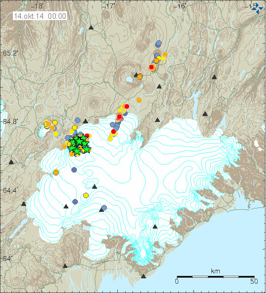
Earthquake activity remains high in Bárðarbunga volcano. With several magnitude 3,0 or larger earthquakes happening every day. There doesn’t seems to be any major change in that activity. Largest earthquake on 13-October-2014 had the magnitude of 4,8 and second largest earthquake had the magnitude of 4,7. Most of the earthquake activity is happening in the caldera that has now dropped some 36 – 37 meters far as I know. There has been increase in earthquake activity along the dyke, suggesting that at least for the time being the pressure inside of it is increasing and dropping between those increases. SO2 pollution is now a problem in Iceland depending on wind direction. This pollution is hard on people with asthma or other breathing problems.
Eruptions under the glacier
Due to the nature of the volcano activity in Bárðarbunga volcano it is clear that eruptions under the glacier are going to take place. They have already happened, so far those eruptions have been minor and only lasted for few hours at the time. Eruption that might last for months at the time as current Holuhraun eruption might start one day without a warning under the glacier. When that happens there is going to be a glacier flood and the harmonic tremor is going to go up once that happens. That does not mean end to the eruption in Holuhraun, since both places can easily erupt at the same time.
Tungafellsjökull volcano
There has been increase in earthquake activity in Tungafellsjökull volcano. Current idea is that this activity is due to stress changes in the crust around Bárðarbunga volcano. Both due the caldera collapse taking place and rift zone is moving by rifting. I am monitoring this activity for any changes that an eruption might take place. Due to lack of any historical eruptions in Tungafellsjökull volcano there is no way to predict or know what happens in this volcano.
So let me get this straight… this volcano is errupting UNDER a glacier?
Shouldn’t that, at some point, cause it to break apart?
800m of ice that ends up over the top of the entire volcano. So yes, at some point it will, but we have no clue of the amount of heat anywhere down there so it could be a subglacier lake waiting for enough melt to get to a low spot or an eruption that breaches the caldera wall.
We have to wait on more evidence to show itself.
@James
tl; dr: There could be an eruption under thinner ice, not that 800 meter thick ice on top but through a thin glacier coming off the base of the mountain.
—
The volcano might be erupting under the glacier right now, there are some hints of that, as Jón mentions, and there were a few small subglacial events early on, but it’s a big thick glacier, especially at the high altitudes up where the caldera is, as others have said.
Where the lava is erupting in fountains now is much lower altitude and just a bit past a place where the ice on top of the mountain has spilled down like a tongue. The ice is not nearly so thick there, but the ground under it has already cracked as part of the same fissure — there are two parallel cracks between which the ground has sunk, in a formation called a graben. You can see it in the following radar image which sees through the ice down to the rock, (or so I believe, maybe the dirt on the lower glacier prevents full penetration of its permafrost), going from the fresh whiter lava going south (down), into the area under the edge of the glacier. http://en.vedur.is/media/jar/myndsafn/full/IsViews_dt05322_o140D_strip014.jpg (Note that image does not show the caldera itself, which would off screen to the left. And see that round whitish hill upper center right? That’s where the webcams are located.).
One of the many things that could still happen is the fissure erupts under that thinner lower ice tongue, where the ground has subsided over the underlying dike of magma, forming that graben. It wouldn’t take too long to burn through creating an ash cloud, and even if it didn’t, a lot of melt water could flood out. Having said that, it’s not unknown for a subglacial eruptions to melt water, but for the seepage to happen so slowly it just blends into the general runoff from the glacier. Or the whole thing could just slow down and stop with nothing more than a few more square km of fresh lava and more SO2 damaging the lungs of the unlucky in its path. So nothing is inevitable. With winter coming in, the rules for how the ice melts are going to be a bit different too.
If a big eruption happens under the thick glacier, e.g. a large caldera eruption, then yes we could see some huge chunks of ice in the mix and breakage of some of the glacier on top. (Not sure what the limits of that are, does anyone know?) Even the lower altitude eruption I described could create some house-sized chunks of ice careening down Iceland’s flooded rivers, smashing into bridges and so on. That’s happened in the past.
I meant this to be a simple explanation. Sorry if I got carried away!
If there have been eruptions,then of what description?Phreatic,phreatomagmatic,magmatic?Explosive or effusive?Mafic or felsic magma?Has any magma breached the caldera floor,or is any activity been just hydrothermal?
Thanks so much for going into deeper details. I find it very interesting and educational.
James, It will take a very large eruption or a small eruption that will go on for a period of time to break through the 800km of ice sitting on top of Bardarbunga’s caldera.
The glacier is around 800 meters thick where it is thickest. I am just assuming that you made a minor typo in your comment. 🙂
The glacier on the rim of the caldera -where also much EQ’s take place- the thickness of the ice is not 800 m but far less (maybe 50-100m) . My estimated guess would be that we see the first action right there on the rims IF something is going to take place in BB. The middle part of the caldera glacier ice sinks faster/deeper than the ice on the rims, so probably the rims are under more stress and thus more weakened than the middle of the glacier.
Curious to hear Jon’s opinion on this!
Sorry, should be 800 meters thick. Thanks Jon! 🙂
National Geographic article and video on the eruption. Great footage.
http://news.nationalgeographic.com/news/2014/10/141013-iceland-volcano-bardarbunga-lava-science/
Thank you for the link. Lovely views and all.
Thanks Jon.
Jon, What are your experienced trained intuition guesses about what’s likely to happen in the system if the Tungafellsjökull volcano goes off?
I realize there’s no precedent about it.
You’re still one of the most educated and aware of the system blokes we have access to!
So, please, guess away.
The *only* Holocene activity in the area is two small basaltic lava flows.
There have been quake swarms in this area previously, notably a couple of years ago; they were exclusively tectonic.
This may be instructive:
http://skemman.is/stream/get/1946/11137/27366/1/The_Fissure_Swarm_of_Tungnafellsjokull.pdf
Mike
These updates keep a sane track of things for us who are not scientifically involved, yet want to learn more.
Thank you.
“it is clear that eruptions under the glacier are going to take place.”
Yes, and I also believe that there have been extrusions of pillow lava inside the caldera. Unlike eruptions under the glacier outside the caldera, eruptions inside the caldera will leave nowhere for water to run off. It will collect inside the caldera. Unlike other subglacial eruptions, this will prevent an eruption from “burning through” the ice. This water will act as a coolant and as long as there is still ice in the caldera, the water will not get much above the freezing point (water in contact with the lava will rise, make contact with the ice, the ice will melt chilling the water which will fall back to the bottom again).
Assuming about a 10% loss in volume when the ice changes to water (it might be more in this case since glacial ice contains so much trapped air), a 14 meter drop in the ice since 12 September would indicate melting of about 140 meters of the 850 meters of ice in the caldera itself. There is not going to be any heat expansion of the water because continued melting of ice is going to keep the water chilled to near the 0 C until all of the ice has melted, if the eruption continues that long. The walls of the caldera will prevent that water from spilling out until the water level crests the walls. It is my understanding that the caldera is about 850 meters deep at its deepest point. The majority of the earthquakes are taking place directly under the deepest point in the caldera. But the caldera is not symmetrical. The north wall is much steeper than the south wall. So the more ice that melts, the more ice/water interface there would be. That means it would take more heat to melt a given amount of ice. This means the slope of the “collapse” of the surface should taper off if the rate of eruptive activity that I believe is happening remains constant. As more ice melts, there is more “coolant” in the caldera and that “coolant” has contact with more ice so the overall rate of ice melt should reduce roughly in proportion to the increase in ice area as the water/ice interface moves upwards.
It is also my understanding that the ice extends some 100 meters or so in thickness above the caldera rim for a total depth of about 950 meters of ice. If the caldera rim is contiguous without any breaks, that means it is possible that the caldera could hold nearly ALL of the water from the ice that fills it. However, there are likely “passes” in various places where water could get out sooner. It would start as only a trickle as the water finally reached a point where it could spill but it would also likely erode the passage and result in even more water flow. That is the point where we will see glacial flood. Also, as this water has been stagnant for several weeks exposed to the lava, it will likely be very corrosive relative to fresh melt water. That assumes that there is enough eruptive activity in that caldera to melt nearly all of the ice.
If it continues beyond that point, we are likely to see only a great steaming caldera lake with little surface evidence of an eruption 850 meters below aside from the steaming. The ice will be gone so the water will now begin to heat. If the eruption continues still, it will become a great boiling cauldron and will remain so until enough water has boiled away to reduce pressure to the point where we will then see surface fountaining.
I still haven’t seen anything yet that invalidates that scenario. To date there has been no observational evidence of the bottom of the caldera (there HAS been some imaging of the surface of the shield volcano outside the caldera with ground penetrating radar). I am still not buying “caldera collapse”, it looks to me like ice melting with the surface dropping as a result.
“Unlike eruptions under the glacier outside the caldera, eruptions inside the caldera will leave nowhere for water to run off. It will collect inside the caldera. Unlike other subglacial eruptions, this will prevent an eruption from “burning through” the ice. This water will act as a coolant and as long as there is still ice in the caldera, the water will not get much above the freezing point ”
That’s simply incorrect. Look at Grimsvotn 2011. Now the ice is significantly thinner there, but still, a powerful eruption went through it like a hot knife through butter; the energy in the initial eruption was roughly of the order of a Hiroshima-size atomic bomb going off *every second*.
A minor eruption at Bárðarbunga caldera might lave no evidence whatever, or produce only small cauldrons in the ice at the surface of the glacier. A major, violent eruption would burn through to the surface in minutes.
It does raise an interesting question: what’s the thickest ice known to have been burned through? I think I saw something about Gjálp a bit back …
(Oh cool found the wikipedia about that legend mentioned in that deliberately weird Icelandic documentary
http://en.wikipedia.org/wiki/Gj%C3%A1lp_and_Greip )
…
ah, http://en.wikipedia.org/wiki/Subglacial_eruption#Gjalp_Eruption.2C_Iceland_.281996.29 better http://earthice.hi.is/gjalp_eruption_vatnajokull_309_1310_1996which was similar in terms of ice thickness on top (750m), and penetrated to the surface just fine, with a lot less fuss than we’ve seen since mid-August. That doesn’t mean every eruption is going to break through, but yeah, if BB wants to breathe, it’ll breathe.
ugh, typo in there. Correct URL for Gyálp is
http://earthice.hi.is/gjalp_eruption_vatnajokull_309_1310_1996
and another one. Gjálp not Gyálp.
Would the water/ice interface move upwards?Does not ice displace 90% of its mass in water?Intense hydrothermal activity is the key in my view,the volcano heats water ,which melts ice,a bit different from magma extruding into ice and being cooled and suppressed.This is purely heat driven using water to defeat the icecap?
Water is much more effective at melting ice than ice is effective at freezing water. (when you drop an ice cube into cold water it doesn’t freeze the water in the glass, quite to the contrary)
Any water in the caldera that is exposed to lava will be well above the freezing point, I can assure you.
Depends in temperature of the ice and temperature of the water.
If ice is at around -5ºC, then water at 10ºC, warmed by the lava at 1000ºC, or by geothermal activity at 100ºC, definitively melts the ice.
If it rains at 4ºC, over ice at -5ºC, then the rain freezes. It if rain is warmer it melts the ice. If it snows (0ºC) falls over similar volume water at 4ºC, it will melt. It all depends in proportions and temperatures.
It’s like a cold night at -10ºC doesn’t freeze the entire volume of a lake overnight. But it can freeze its surface. A temperature of -40ºC would freeze even a good sized lake.
Sam principle with permafrost.
Hm I am going to Iceland for one week in November. I have breathing problems similar to asthma and am beginning to worry about the air pollution. I’ll be around Reykjavik, the south coast and Snaefellsnes peninsula. But am beginning to wonder if I should cancel it?! :((
Consult your doctor!
You can go here (see below) to see measurements of air quality. If you look at the graphs, you notice that so far all SO2 spikes have been short lived and most of the time the air quality is better than in most cities.
Click the blue or yellow dots on the map, and then “more” for details for each station.
http://www.ust.is/einstaklingar/loftgaedi/maelingar/
At a water magma interface at only 800m down there would be steam explosions and implosions. Also magma contains a lot of gas which would also implode on rapud cooling. Also the would be cracking of magma conduit walls. The whole system would resonate giving rise to volcanic tremor. I see no volcanic tremor evidence. If anything over the past few days the tremor has been reducing. I think the may be a quite period ahead. Tremor is a clear indication of eruption. No tremor, no eruption.
Ice melting during subglacial eruptions (Magnús Tumi Gudmundsson, etal.): http://www.agu.org/books/gm/v140/140GM04/140GM04.pdf
Tremor charts from the onset of the Grímsvötn 2011 eruption (Jón):
http://icelandgeology.net/?p=960&cpage=1
PS: The Grímsvötn 2011 eruption was subglacial, but the ice on the lake is not so thick as in our case at Bárdarbunga.
Some IMO material on seismic activity under Vatnajökull:
http://en.vedur.is/media/jar/KSV_eq_locations.pdf
THANKS y’all for the interesting posts & articles.
Fascinating.
+1
Thank you all for sharing your knowledge about volcanos! Have been following you folks and You especially Jon now for over one month! Has broaden my mind and deepen my understanding a lot of this subject! Keep up the good work!!
But if Holuhraun craters are getting higher, the result growing resistance. If these craters about 100 meters high, the outlet would feature does not expire?
Thus thereon due Bárðarbunga then grow in strength
No that is not the case, the pressure if it built would be in the dyke and subsequent release would be at a new point of failure above the dyke.
The dyke is sucking magma out of the lower chambers of Bárðarbunga( causing the plug to drop steadily) and not the other way around.
Intense hydrothermal activity would work. Probably ice would melt with the relatively warm new caldera sides and seep down. Also magma is likely to be nearer at the fault providing more heating. Water would probably seep through to inner ring faults and rise again forming a cieculation system.
On glaciers, hydrothermal systems and jökulhlaup in Iceland (Helgi Björnsson):
https://notendur.hi.is/oi/Pdf%20reprint%20library/Subglacial%20lakes%20and%20jokulhlaups%20in%20Iceland.pdf
K. Vogfjörd on the FURTUREVOLC project and planned extension of the seismic network around Vatnajökull: http://meetingorganizer.copernicus.org/EGU2013/EGU2013-13319.pdf
The Abstract is from 2013, would be interesting to know which of the plans have been carried out.
She btw. mentions also the possibility that hydrothermal systems also could cause harmonic tremor and so lead to misinterpretations of data.
I hope this activity stops then we ca drill for evidence. Otherwise all the speculation will head skywards.
There has been the logic or reasoning pushed that what we are seeing in Bardarbunga is simply a slow caldera collapse, because there is not enough magmatic pressure to start a volcanic eruption. The suggestion is that the rifting in late August created dilational forces which pulled the crust apart, and so magma rushed in from the mantle below to fill the void (so to speak) According to this reasoning, some pressure does exist (hence the Holuhraun flows) but not enough to fuel Bardarbunga, hence it is slowly sagging. The fissure allowed the excess pressure from Bardarbunga’s magma to seek an easier exit, hence the odd right angle turn when the fissure system was hit. The rifting is hypothesized to have lowered magmatic pressure at Bardarbunga.
Is this a reasonable hypothesis?
Has anyone studied the types of quakes seen in the dike fissure? Are they from expansion of the dike? Or is the dike pretty much set in place? Did the magma initially push the walls apart, or did tectonic forces pull apart a crack which the magma filled? ( I favor the latter, due to the fact that a minor eruption occurred, quiet ensued, as the magma caught up, then the Holuhraun eruption started)
I know that we all witnessed a major rifting event, is more rifting on the way within a month or two? Does anyone know?
My guess is that the magma flowing under Barda is melting and eroding the bottom of the plug causing it to sink … sort of like how a sink hole forms.
I used to watch montserrat, and one of the things that happened there with the dome building was huge cold lava formations would thrust up over weeks, only to collapse into rubble in spectacular fashion quite suddenly. Which is by way of intro to a question that comes to mind: exactly how stable is that plug? Is it solid rock, or breccia loosely composited? I’ve seen the drawings put forth by a scientist a few weeks back showing an eruption of a vent going up the side of the plug. But what if the plug just crumbled into an underlying void? Or is it like Devil’s Tower in Wyoming USA, so solid it will remain even after the rest of the volcano is gone?
Is it a plug as such,or just jumble of material left over from a caldera forming event , subsequent eruptions and hydrothermal activity.A jumble of unstable geological layers,supported by a solid or semi solid mass of old magma?
You sure that there would be measurable harmonic tremors at 800 meters water column depth? Subglacial might as well be submarine. Volcanic activity in Antarctica provides for a comparison here.
According to this http://earthice.hi.is/sites/jardvis.hi.is/files/Pdf_skjol/Jokull58_pdf/jokull58-jakobsdottir.pdf
The South Island Lowland (SIL) network has a station on BB (or very close). The transmission of sound through rock rather than ice/water would be detectable. These sensors used in geophones and seismometers are incredibly sensitive. I used to work on a geophone sonde tool inserted in a borehole listening to micro EQs caused by circulating water kilometers away. We could hear allsorts of stuff. I think jon mentioned in passing disturbances caused by an animal walking by. Sorry if the paper is not up to date and I have no info on the Alaska network but SIL is very extensive.
Not disputing that but I remember something from a long while back about rock in Iceland being less capable of propagating seismic waves than in some other places, due to being very fractured.
I’d like to think we can agree any new eruption would cause increase in tremor, which would evade detection only in the event of a major storm. As Jón says though, minor eruptions like what may have happened over the weekend might need flyovers and measurements of cauldrons (dips in the ice, not to be confused with calderas) to be confirmed.
Map of the SIL network in Iceland:
http://gps.vedur.is/mapSIL.php
The stations next to Bárdarbunga are DYN and VON.
strange quake activity in grimsvotn plot…
Jon you should be a volcanist, you were the best!
and what means if flooding water is red, iron oxide, and people your many new frends , ask now the same which i answered one month ago,
i go now, good life
imri
Magnitude 4.4
Region ICELAND REGION
Date time 2014-10-14 13:03:04.9 UTC
Location 65.38 N ; 25.01 W
Depth 10 km
http://m.emsc.eu/earthquake/earthquake.php?evid=404196
Is it possible that the magma closest to the surface ,is under the caldera rim ,the rest of the magma is possibly still quite deep and causing glacial melt via hydrothermal activity?If this is the case then could partial caldera rim failure(landslide) be a risk?
Is the BB caldera rim not made of solid rock and surrounded by thick Ice(glacier) so in answer to your question it would require a massive amount of Ice melt to free up a segment of rim so it could slide.
That said the formation of multiple cauldrons above the rim area would confirm that there are and have been events occurring directly underneath. Possibly heat interactions between escaping heat from chamber 1 Rhyolite mush as the plug descends and the glacier above it on the floor of the BB caldera.
Not really that solid?Heating has an effect of weakening rock.
http://davemcgarvie.wordpress.com/2014/08/02/askja-volcano-26-july-visit-to-the-2223-july-2014-landslide/
I remember reading (I should start a biobliographic index, dammit, or better, we could start one collectively e.g. via Zotero — could well have been Dave McGarvie though) that BB’s caldera rim is higher than a rim formed by non-sub-glacial processes, and was caused by processes quite different from those of non-glacial volcanoes, and that it stands in place thanks in part to the ice around it. So arguably, if something happens to that ice, the rim could prove quite unstable in its absence. *If* being the operative term, of course.
I continue to wish I knew how much heat escapes BB’s magma chamber to the sub-ice surface. In the absence of evidence I have to assume not much, but if I understand it there used to be two subglacial lakes in the BB caldera, and now it’s down to one since one of them ran off at the beginning of this event. Those got their heat from somewhere, right?
Wial ,a hunch I have is as the number of larger 5mag quakes decline more heat will migrate to the surface,if it starts to thaw or is already thawing rapidly the ice at the rim fault,maybe that could destabilise the base of the steep rim.Heat and water saturation,may take its toll on the geology.Potential perhaps for a multi faceted event?But hey what do I know .
http://adsabs.harvard.edu/abs/2010EGUGA..1213588D
Something wrong here? Could be an error
http://www.vedur.is/photos/volcanoes/bbgpseqmap.png
Maybe an error. There’s a gap in http://strokkur.raunvis.hi.is/gps/URHC_3mrap.png
Vertical GPS displacement data back:
http://en.vedur.is/earthquakes-and-volcanism/gps-measurements/bardarbunga/caldera/
Jon or anyone, is there something going on with Hekla ? The tremor plots seem more active ?
I think it is not Hekla, as eg. Haukadalur (hau) seems not be reacting.
But these SIL stations seem a bit more lively now since about 2 days: mjo, fed, jok, perhaps also sly. Station vat did something strange at the same time, but it looks more like a technical glitch.
MrsDan (I think that was her name) posted a great link on here last week. It may be of interest to the new people joining this site.
http://weerstationlangerak.nl/bardarbunga/
Thanks!
This is the new domain for the site: http://icelanderuptions.com
The other one will be redirected in a while.
GPS station URHC exit stage left (3.5cm+) today. !
Just the uncertainty for this station is huge 🙂 (look at the red/green circles)
There’s a gap in its data which might be affecting the calculation. Maybe the same problem as the subsidence graph? http://strokkur.raunvis.hi.is/gps/URHC_3mrap.png
Hey what’s going on with this low freq. rise on Katla tremor plot?
Which one?
There are: alf, hvo, rju, slys. (I think these are all the functionin ones at the moment.)
functioning
Slysaalda… by the way big quake 5+ i think.
What I think is, that this whole area is a bit restive (see my comment 20:02). This would be around the southern end of Bárdarbunga volcanic system …
Nothing to do with Katla in this case, I suppose.
Luisport, I dont see anything unusual. Which link are you using?
I don’t see anything that seems outside of background either in Katla, Hekla or Grimsvotn.
Can’t figure out what you mean.
Maby this is just weather or something else… or only my inexperience, but i see in Katla and Hekla the rising of lower freq. The interpretation of tremor plots is a triky thing… http://weerstationlangerak.nl/bardarbunga/
Quirky pattern over last 24hrs the larger plus 4 magnitude EQs have come approximately every 6 hours.
Here’s a great video from 10 October :
https://www.youtube.com/watch?v=liZF2nshtrs
Dunno, but I see a change since the large quake. There is a sudden uptick in the plots…
And hopefully the link will work now…
http://s9.postimg.org/i7lbkyw3j/change.jpg
why don’t you send the link to the data source
Sorry if this is a stupid question but what do the small black triangles mean on the earthquakes map on vedur.is?
Hey James!
Please have a look at http://hraun.vedur.is/ja/englishweb/vatnajokull.html
Esp. the last sentence.
Thank-you
I was looking at GPS trends in Iceland (most stations showed rifting W-E between Bardarbunga and Askja, but Vonarskard moves east, Grimsvotn moves north, and Hamarinn and Jokulheimar moves northeast
Then, I came to an outstanding conclusion:
Interestingly Kalfafell, south of Laki, also shows a slight movement northwards, so it mirrors Grimsvotn movement. So it seems that rather than being just Bardarbunga sinking, and stations moving towards it, that this is a much wider tectonic plate of the southeast part of Vatnajokull (south part of European plate) moving north, while the northern part of the plate, north of Vatnajokull, moves mostly eastwards.
This movement is interesting. It’s like the European plate moves northeast, while the American moves slightly west. This creates a perfect rifting north of Dyngjokull. One side moves NE or E, another side moves W. Perfect conditions for the crust to open and pour lava outside.
But south of it, under the ice cap, the movement is more like American side moves SW, while European side moves NE, almost like slip-strike faulting rather than rifting, so that’s why we DO NOT SEE an eruption under the ice cap. If the European plate would move southeastwards then an eruption would of course start at Hamarinn or Thordarhyma.
An eruption at this point, with the current wide tectonic trends, can only start where faulting occurs north-south, and that’s at Holuhraun. At Askja and Herdubreid, faulting has same alignment, so I think that an eruption could also occur there in the future. However tectonic movements has not propagated there yet. Strain is being released in the form of the swarms we see sometimes at Askja and Herdubreid.
South of Bardarbunga rifting shouldn’t also occur, because the European plate is moving northwards instead of eastwards. While the American plates barely moves. However this European movement can create a pulling tension further southsouthwest, somewhere between Oraefajokull and Katla, so perhaps we could see an eruption occuring there some years down the road.
Even more revealing is this. Vonarskard moves east, the stations further west move westwards. So at Tungnafellsjokull the crust is ripping open. It is not surprise we see earthquakes there. And an eruption can be much more probable there.
From my GPS discussion, I came to an outstanding conclusion:
Interestingly Kalfafell, south of Laki, also shows a slight movement northwards, so it mirrors Grimsvotn movement. So it seems that rather than being just Bardarbunga sinking, and stations moving towards it, that this is a much wider tectonic plate of the southeast part of Vatnajokull (south part of European plate) moving north, while the northern part of the plate, north of Vatnajokull, moves mostly eastwards.
This movement is interesting. It’s like the European plate moves northeast, while the American moves slightly west. This creates a perfect rifting north of Dyngjokull. One side moves NE or E, another side moves W. Perfect conditions for the crust to open and pour lava outside.
But south of it, under the ice cap, the movement is more like American side moves SW, while European side moves NE, almost like slip-strike faulting rather than rifting, so that’s why we DO NOT SEE an eruption under the ice cap. If the European plate would move southeastwards then an eruption would of course start at Hamarinn or Thordarhyma.
An eruption at this point, with the current wide tectonic trends, can only start where faulting occurs north-south, and that’s at Holuhraun. At Askja and Herdubreid, faulting has same alignment, so I think that an eruption could also occur there in the future. However tectonic movements has not propagated there yet. Strain is being released in the form of the swarms we see sometimes at Askja and Herdubreid.
South of Bardarbunga rifting shouldn’t also occur, because the European plate is moving northwards instead of eastwards. While the American plates barely moves. However this European movement can create a pulling tension further southsouthwest, somewhere between Oraefajokull and Katla, so perhaps we could see an eruption occuring there some years down the road.
Even more revealing is this. Vonarskard moves east, the stations further west move westwards. So at Tungnafellsjokull the crust is ripping open. It is not surprise we see earthquakes there. And an eruption can be much more probable there.
In a word, I expect more likely eruptions in next years, eruptions at Holuhraun, Askja, Tungnafellsjokull (as crust us under tensional rifting there), and somewhere between Katla, Edlgjá-Laki-Thordarhyma, Oraefajokull, as European plates moves northwards and creates tensional opening, directly south of Grimsvotn.
No eruption expected, according to my model, iun the ice-cap, along Bardarbunga fissure swarm, north and south, including along the dike. Due to the fissure swarm alignment requiring a SE movement of the European plate, instead of a N movement.
My guess caldera moving from the strong earthquake ,magma chamber heating phase to strong influence from magma on the surface,with increasing hydrothermal activity and increasing glacial melt.
Just one thing, you don’t have enough plates! 🙂
Google ‘Hreppar microplate’.
It’s more complex than you suggest. Pall will put you on the right track:
http://earthice.hi.is/sites/jardvis.hi.is/files/Pdf_skjol/Jokull58_pdf/jokull58-einarsson.pdf
Mike, I know about Hreppar of course. I just over-simplified this model.
What we know is that plate movement has occurred over the following areas over the past decades; Hekla, Westman Islands, Eyjafjalljokull, and SISZ. And now between Bardarbunga and Askja. And north if movements have occurred between Askja ans Krafla.
This indicates a relieve of rifting tensions, however there are points at Hreppar that have not moved, and this is the area north and east of Hekla and south of Bardarbunga and Grimsvotn. I think these areas have a rifting tension accumulated. This basically allows for rifting to potencially be released in the future at either the rifting area of the dead zone or south of Langjokull.
Where have we seen most movements, at Grimsvotn, so next in line could be Thordarhyma. Or perhaps rifting could start from the other point, at Katla.
The other area south of Langjokull curiously has seen ocasional swarms, so tectonic strain is present there.
Besides this the other obvious regions to look for tension, is near Hengill, at Tjornes and obviously at Reykjanes.
The other possible
@Gizmo: thanks!
The NNE Side of the caldera where the rift intersects has taken the highest pummeling. Whatever type of rock it was its certainly well faulted and smashed now. Coupled with rifting this will prpbably be the first point of failure. We’ll just have to wait and see
I am inclined to agree.
That area seems the most likely for eruptive activity to start.
It’s always been ‘well-faulted’; calderas have ring faults, that’s WHY they’re calderas. What’s happened is that the combined effects of magma movement and the changes in the regional stress field have caused those existing faults to become active.
New article is up on Bárðarbunga volcano activity for 14-October-2014.