
This information is going to get outdated quickly. This is also a Friday update and that means I won’t write new articles during the weekend. I am just going update this one with latest information. New article is only going to be written on weekends if something major happens in current activity in Bárðarbunga volcano.
Current status of Bárðarbunga volcano at 23:43 UTC
- Largest earthquake so far today has had the magnitude of 4,7 at 06:44 UTC. Other earthquakes have been smaller, but several magnitude 3,0 – 4,3 earthquakes have taken place today. More information can be found at Icelandic Met Office website here.
- GPS data [University of Iceland GPS data can be found here) still makes no sense to me currently. I am hoping to figure that out in next few days what is going on there.
- Landsnet that takes care of the electric grid in Iceland has started to move backup items for its power-lines in south and north Iceland. In the case they need to do a sudden repair to them if they take damage in glacier flood. This are 220kV power-lines and stations that are at risk from glacier flood due to eruption in Bárðarbunga. I don’t know about the dams them self if anything is being done to protect them.
- The eruption in Holuhraun continues as it has been doing for the past few days. Now there is mostly one crater erupting.
- Chemical mixture of the magma has changed. It is now coming from deep magma chamber at more than 10 km depth. This means the eruption is going to be long lasting.
- Scientist expect to be at Holuhraun eruption until December at least.
- South part of Bárðarbunga fissure system have not yet started to move. When that changes is impossible to know.
Map of earthquake activity for the past 48 hours
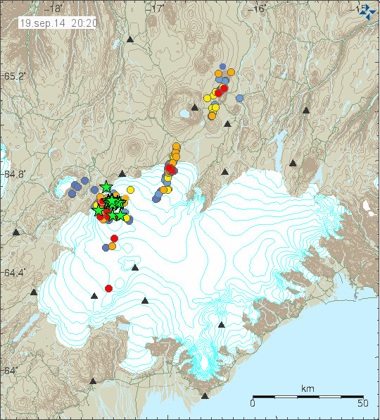
This is the earthquake activity from 20:20 UTC. It clearly shows the earthquake activity as it now is taking place. Copyright of this image belongs to Icelandic Met Office.
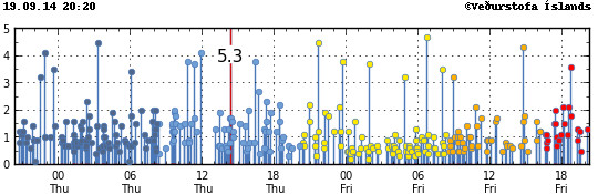
Magnitude of the earthquakes taking place during the past 48 hours. Copyright of this image belongs to Icelandic Met Office.
Update Saturday 20-September-2014 at 13:16 UTC
- Largest earthquake since midnight was an earthquake that took place at 01:10 UTC and had the magnitude of 5,1.
- Eruption at Holuhraun continues same as before. The central crater is now high above the flat desert that is in this location. I don’t know how high it is now.
- SO2 pollution have been noted over Iceland today. It has been seen in Reykjavík, Borgarnes, Akranes and other places. The amount of SO2 in this places is far below health risk levels according to the news.
- Minor earthquake activity continues in the dyke and has extended slightly more south since yesterday.
- GPS data continues to be confusing. GPS data from Icelandic Met Office can be found here. GPS data from University of Iceland can be found here.
Update Sunday 21-September-2014 at 14:35 UTC
- The eruption continues as before. There is no major change taking place in Holuhraun.
- Largest earthquake since midnight is a magnitude 5,5 earthquake that took place at 10:51 UTC. Other earthquakes have been smaller. This is the second largest earthquake since activity started in Bárðarbunga volcano. With the largest earthquake so far taking place on 26-August-2014 having the magnitude of 5,7.
- People have found going into the closed area and that is illegal. This is dangerous since there is high risk of new eruption taking place under the glacier south of current eruption. When that happens the glacier flood is going to coming down to the current erupting area within 30 to 60 minutes (1 hour). That is not enough time to send warning to all the people in the area. If you want to go to Holuhraun, rent a plane. Its the safest option at the moment. Don’t go by car! Small eruptions have been taking place under the glacier in past month. So we know they are happening, they have not been large at present time, but that is going to change without warning. There is also high risk of gas like SO2, CO, CO2 from the eruption.
- Dead birds have been found close the lava field in recent days or weeks. I don’t know why this happens, but it is clear that deadly SO2 gas and other gases are killing the birds.
- There is a storm in Vatnajökull glacier area today. As can be seen on Icelandic Met Office wind map here.
- Eruption in Bárðarbunga volcano is expected to take place without warning. It has not yet happened, but the chance of an eruption taking place is higher than it won’t happen.
- Bárðarbunga volcano caldera continues to subside. Latest drop was around 25 cm following the magnitude 5,5 earthquake.
I am going update this later today if there is reason to do so.
Article updated at 13:16 UTC on Saturday 20-September-2014.
Article updated at 14:38 UTC on Saturday 21-September-2014.
Article updated at 14:41 UTC on Saturday 21-September-2014.
usgs reporting it as 5.1 at 5km, maybe this is a different quake.
No, it’s the same quake, but IMO are taking their time with the big quakes to compare numerous seismo’s and give accurate fiugures. EMSC & USGS are approximations made by an automated script and are not accurate.
I will stop posting the EMSC USGS quakes on here. They are just come as a warning on my mobile via the EQinfo app. IMO are the most accurate data.
Just had a look at the BB GPS link posted by hyper al, if i’m reading it right (the blue line) that area has gone down by around 1.75 meters since around midday Friday!
it’s just, making an average of 0.58cm a day, so nothing different compared to last week
58cm is over 3 complete days, 12 midday friday to 12 midday sunday is only 48 hours so it would be something like 87cm per day!
Whats going on at GOD? Tremors are going up… real fast
do you have GOD link?
http://hraun.vedur.is/ja/oroi/god.gif
godabunga is no in the area from BB, it at Mýrdalsjökull, the last EQ at this location was saturday at 23h50, 2.4 at 0.1km deep, but wait and see…
Several tremor measurements are going pretty high at the moment. http://hraun.vedur.is/ja/oroi/allarsort.html
Von in particular, definite change on the Y-axis baseline as well as being quite intense.
certainly looks like it. Maybe Jón will report on this.
Wind noise again, perhaps ?
Wind is coming up, some of these sensors are very sensitive to when the wind blows and it can register as tremor.
This is the wind which is seen on the tremorplots
I really have no idea about these things, I just watch and read quietly, but would the gale force winds that are forecast from lunchtime today have any effect on the high tremor measurements you are talking about?
a strong gale is expected south of the island, and godabunga is in the south.So this tremor going high is the consequence.
yes, it could be the wind, forecast mentioned gales.
I tend to agree with this being wind. Yet the steepest increase in tremor is a Vonaskard, is this station particularly exposed to South-West wind?
I saw fog yesterday. But the darkness on Mila 2 doesn’t look like fog to my opinion . . .
They both look black or offline ?
kverkfjoll webcam looks like fairly dense fog (but just “normal” fog) since 2hrs ago.
IMO confirmed mag 5.5, how long before we get a mag 6+.
I’m not convinced the tremor increase is from wind… Not yet anyway. Jon’s Heckla Geophone shows a lot of wind noise and right now there isn’t much there and the wind speed isn’t too great either. The IMO also says Gale force winds later this evening so it don’t look like it’s windy enough yet in my opinion to cause a false reading on the tremor graphs just yet.
Yes, that is what was surpring me with the rapidly rising tremor at vonaskard. it’s not supposed to be the most wind-exposed place today, and other IMO stations around the south west should have more wind-induced effects today. Although ignoring these arguments, I agree it “looks” compatible with wind.
I think it is wind. Look at the B2 cam. It is shaking from the wind.
I am still wondering if the BB caldera will fall in or just keep sliding until it stops.
Miss Bardarbunga has produced 26 above 3.0 EQs in the last 48 hours. Wow! How much more can the volcano and the crust take? I am thinking that something beside the eruption now in progress has to happen soon! Jon or others who are experienced please tell us what you are thinking on this subject.
So? Sure, it is something, but as for how much the crust can take….
“Often felt by people, but very rarely causes damage. Shaking of indoor objects can be noticeable.” Description of M3.
M4 description: “Noticeable shaking of indoor objects and rattling noises. Felt by most people in the affected area. Slightly felt outside. Generally causes none to minimal damage. Moderate to significant damage very unlikely. Some objects may fall off shelves or be knocked over.”
A lot of them in one general area should be noted and one might be the straw that breaks the camel’s back, but otherwise….it’s a bunch of small shocks that many people wouldn’t notice.
Here’s a graphic for you: http://www.sdgs.usd.edu/publications/maps/earthquakes/rscale.htm
Making a small OT point here. It has often been mentioned that some look to an increase in EQ as a “sign”. Many dismiss it because if you actually evaluate what we know, it appears that the current number of EQ we have are fairly consistent with earlier centuries. Sure, except you can now look at plots of EQs and see *millions* detected that were never noticed before each and every year as each and every teeny tiny shake gets noticed & recorded.
So, Bardarbunga & vicinity are being subjected to lots of activity that cannot even be noticed by human senses. Interesting, we should learn more from it, but not be alarmist about the little stuff….unless you have a new theory that can be observed, repeated and confirmed…
When I was in Iceland earlier, May 2014, a hotel owner in Fludir said when a week before we arrived a 4 Eq felt like a car had just ran into his building. I am unaware where the epicenter of that.
I was in Iceland earlier, May 2014, a hotel owner in Fludir said when a week before we arrived a 4 Eq felt like a car had just ran into his building. I am unaware where the epicenter of that.
The epicenter in this case (Flúdir) could have been very near his house which would explain the feelings about it.
The village is part of the SISZ in South Iceland which is a known transfer and earthquake zone between the older (Western) and newer (Eastern) Rift Zones.
Thanks for the ideas and explanation, Larry A on what is happening. I am just an observer and not an expert, and all information is helpful. Please understand I am not a panicky person, and live in hurricane territory in the US. We just prepare and hope for the best. Hoping the people and government of Iceland continue with the preps that are now going on.
I do not know how big an earthquake can be from a volcano. I would think to get something like 7 – 8 on the richter scale it have to be the full forces of the tectonial plates. That has to carry so much more force than a small lava container that have a wall broken?
Heh, born & bred in hurricane territory. I’ve met two people who came from different places that got in a panic about hurricanes. The first was a girl from the town in California that has the most US EQs, to her, they were no big deal, just something to be ready for. The second was a guy from Kansas and was all worried until I pointed out the biggest danger was tornadoes where he was living. CLICK, the resident of Tornado Alley went into anti-tornado mode and was fine.
Remember that when you compare with other disasters, people still live and build by the “beast” (whichever natural disaster you care to name) and don’t worry about it. I missed some smaller EQs because they felt like home when the train was running down the hill (stuff on the edge of shelves would eventually fall off from vibration), but I will admit that the first time the earth moved for me in a non-romantic sense, I freaked.
Nobody in Iceland has seen anything like this before. The eruption now is already larger than Kröflueldar that took place 1974 – 1984 and we are just speaking about one fissure that has mostly been erupting so far. Not counting all the small eruptions that have been taking place under the glacier in the past three weeks.
There is a possibility that eruption of what Bárðarbunga volcano might be preparing for has not happened in Iceland for at least 300 years, maybe longer (difficult to know for sure). The fissure eruption in Bárðarbunga during the years 1862 – 1864 was big like this one. The fissure was 15 km long that erupted. Current fissure was at its longest around 2 km long.
I have updated the article with latest informations.
Thanks for that update, Jon. You write that you now think that the risk of an eruption at BB is bigger than the chance of no eruption happening at BB.
But how about eruptions (fissureeruptions) outside BB – will they be likely to stop if/ when BB erupts?
Finally – earlier on you and others wrote that this would be a 3-5 year event – Do you still think so and in that case, where on the timeline do you expect an eruption at BB to occur??
It is not just my view. This is also view of the geologist that are monitoring the eruption at University of Iceland and Iceland Met Office.
This position is quite reasonable and is reflected in the stone tablets when you realize Scenario #1 is showing no signs of occurring. Subsidence ongoing, eruption at Holohraun is at least steady if not strengthening.
Probability etc. of course based on current conditions which can change arbitrarily and without warning. But off current conditions…yeah, this is #2 or #3.
I think it very good and necessary that you mention here also the dangers folk may encounter at the eruption site, thank you for that also.
Almannavarnir has been mentioning that also espcially again today. http://www.ruv.is/frett/lifshaettulegt-ad-virda-ekki-lokanir
There are reports about the eruption producing between no less than between 60.000 and 90.000 t/SO2 per Day. http://www.visir.is/section/MEDIA99&fileid=VTV88F60CD7-CC36-41E1-931D-18C37F5417B1
The scientist Dr. Gylfi Arnarson says the data are provisional, but if other tests show the same, it could be a record quantity.
English version of the RÚV text about dangers at eruption site:
http://www.ruv.is/frett/disregarding-closures-life-threatening
Is anyone else unable to connect to the cams on Mila website?
Unable to connect for the past hour and more. Server overloaded or down, perhaps?
I haven’t experienced any problems with connection today, Tom.
Oh.. and a 4.2 just now according to IMO.
There’s not a lot to see due to weather, but here’s another youtube relay: https://www.youtube.com/watch?v=n7W9DLxLh8g
Thanks for that.
I’ll explain your dead birds. The IDLH level for SO2 versus humans is 100ppm. This is a level where you may at minimum be so incapacitated that you cannot escape. In which case, you will eventually die if it doesn’t dissipate or you are not rescued.
This is an advisory chart which uses PPM rather than µg/m³. The levels are the same as the µg/m³ chart; red is red:
http://hiso2index.info/assets/FinalSO2Exposurelevels.pdf
We have hit red+ several dozen kilometers away from the site and that is for humans. I have no doubt that something <100th the mass of a human that flies anywhere near the plume is done. Maybe not immediately, but that doesn't matter for poor birdies.
The journalist and aviator Ómar Ragnarsson who is very familiar with the region of the eruption because he looks after an airfield there, said in his own blog that this year migrating birds left the area long before their usual time. http://omarragnarsson.blog.is/blog/omarragnarsson/entry/1441686/
Interesting, I think. Perhaps there were degassings which the animals felt long before the real eruption and rifting crisis.
There’s a reason for the saying : “Canaries in a coal mine”
Thanks for the update Jon. You are doing a great job. It is helpful to get information from the folks who have studied Iceland’s geology and can piece together all the data in a way that can be easily understood. All efforts are greatly appreciated.
For any newcomers wondering about a Jokulhlaup, this is the outburst from Eyjafjallajökull –
https://www.youtube.com/watch?v=fJII-u-41Lg
And this was a rather small one.
After much study, I have just arrived at an alarming conclusion. I have been tracking the quake patterns at Barda along with the size of the eruption, looking for patterns and correlations. Here’s what I found:
Every time Obama’s travel plans take him closer to Barda, within a certain distance, soon after, The eruptions and quakes start spiking. When he was over in Estonia and the UK on 9/3-4, he was so close that the Caldera started its collapse and was at the fastest rate so far. After he left, the rate of subsidence started to fall.
I am very worried at this point, because he is set to travel again to Europe for some
G-20 meetings in November. I am also working up some correlation graphs for events surrounding Putin as I am seeing a pattern here too.
Its the Man-Earth spiritual connection forces at work here and we are in for quite a ride!!
I also coincides with my visits to the loo, and I’m worried that the gaseous vents may be travelling along waste pipes from Scotland to Bardarbunga.
It’s just an theory though 🙂
I would be a lot more worried about Obama’s and Putin’s gaseous events that emanate not just from their GI but their mouths, not to trivialize your GI issues.
Obarmy’s going to Australia for the G20 summit. As far away from Barda as you could get. – except for Antarctica.
The volcanoes near Cairns in Australia (where the G20 summit is happening) haven’t erupted for over 20 million years. – Lets hope they stay quiet.
During last days EQ M3-M4 had been repeatedly increasing and happened “tied up as EQ sequences”as seen at IMO’s tables…
This 5.5 of today is major thing again.
Although fountains had not been active all time, today morning very high blows had been seen through BB2Mila(higher pressure)….I would say 100mts high maybe at times? with big walls and outcome volumes and huge river of lava as seen on helicopter vids from yesterday… the activity is “speeding up” average, even if sometimes feels decreased..
Very interesting to follow. Like if soon or very soon fire also meets the ice, at sight.
Offtopic about Mila (i excuse myself in advance, and thank you for the serviced camera&views!)
Couldn*t they fix a better cam soon or late? I understand when all starts to fix cameras is difficult, but now it’s known where activity is happening so maybe a better zooming camera with better lens could be placed there soon, so when good wheather, get better footage without needing an helicopter…might cost the same or almost the same to install the cam point wireless anyway, so better resolution shouldn’t be a problem for the University….
Mila interface could be a bit updated too since many links are broken.
Sure some students would be glad to do so for a better service…and for this unique event.
Marc, This pattern has to do with Putin flying his nuke bombers near Switzerland, UK, Alaska and Canada and threatening to invade Europe and to Nuke anyone who tries to stop him from taking whatever he thinks is his.
This sort of comment really has no place on this blog.
Please do not post this thing here. You do have other places to do so on the internet. Use them.
Perhaps “the jumps” on the gps subsidence curve can be caused eq M5,3+
Zyfly: your perspective is distorted. It’s much more likely to find a random person whose travels correlate with the eruption activity. You just don’t have all the information to make such claims.
zyfly is exploring the new world of politico-fantasy fiction.
Thanks again Jon – Im not at all doubting you – or the authorities – on the contrary – I take your opinion very seriously – I have great respect for You and your work and – you inspire med to :3
Im still not sure whether You and other experts, still think the whole event will last 3-5 years or if that has changed? I´d really like to know :3
By the way – where would you advice me to start taking classes on volcanology (Open University classes) here in Denmark – Is there somewhere or someone you would advice me to lean on??
Given the limited historical data that we have. This might last as long as ten years, with breaks that might last for longer or shorter period of time.
Zyfly: you comments are bizarre and have no relevance to this blog, We are all only interested in whats happening in Iceland. It is very serious, for the Icelandic people and potentially the rest of the northern hemisphere. I suggest you take your stupid comments them elsewhere.
You obviously are not aware of the spiritual connection between the earth and people who wield vast amounts of power and influence over human events. There is also the possibility that someone could be concealing their contempt for these leaders disguised in jest.
Disguised in jest, lol.
Can you please stop this. If you are looking for a humour I suggest that you try The Onion forums.
Hi Jon
In your update you’re writing “If you want to go to Holuhraun then rent a place”. What do you mean by that? Rent a place where? Is it possible to go with the scientists?
I’m flying to Iceland next saturday (if Bardarbunga let me fly…..).
I’m looking forward to your answer.
Best regards
Rina
It was a spelling error. I have corrected it now. People can go to Holuhraun by plane or a helicopter that can be rented with a pilot. It’s not cheap, but that is the only way to see the eruption in a safe way.
As mentioned earlier, keep religious comments and supernatural / conspiracy theories away from this site. It contributes nothing.
Zyfly is pulling your leg, folk. Teasing, for those of you not familiar with the idiom. He isn’t serious, which I would have thought was obvious.
But it’s idiotic also…if he has nothing to say…so why spend the time of the readers?
I think the odd humorous comment is acceptable in good taste, but with moderation. I joked back at the original comment but thought that was it. I think he has perhaps had one too many and may have realised by now he’s overstepped the line a wee bit.
Some of us also follow vc and there’s a bit of banter over there, but in good taste!
But Jon has not so much space for every not-funny-joke with all followed answers. Jon had payed a lot of money 2011 for more space for some chatting persons and as he asked to stop it they are going… but Jon has to pay at least… a little joke here and there is ok…but one time is enough…his joke will not be better if he posted it once again…
and now I ignore it/him
Fair comment.
Does anybody know, what is overall glacier subsidence? Jón earlier mentioned, that the critical value is about 45 (?) metres.
You’ll find it here –
http://weerstationlangerak.nl/bardarbunga/index.html
That doesn’t answer the question?
thanks, but Icant find there the original glacier altitude
The subsidence is far from uniform. The deepest significant band was 22m on the 17th (last overflight I know of) so it would be approaching 25m now.
There is a very large area that was at least 10m down on the 17th.
thank you very much, so we are approximately on the half of the “critical value”
I think Jon recalculated the threshold value and said it would be more. Maybe he can state how he did the calculations and what’s his latest conclusion regarding a threshold.
I think it could be more than 45 meters.
Askja went down by around 300 m before the caldera eruption in 1875. But Askja had no glacier on its top.
@Mette Valentin and everyone else interested in learning a bit more on volcano’s.
Coursera.org will be offering a course called
Volcanic Eruptions: a material science.
Beginning October. Check it out.
Thanks a lot Dionne – Ill check that out and try to get allow to follow the seminar 🙂
Good one, am going to try the course. This site has re woken a love of all things volcanic!
Thanks Dionny for this informati0n. I will attend this course. 🙂
Dionny, thanks so much for sharing about the course: “Volcanic Eruptions: a material science”. Sounds awesome! I’ve enrolled and can’t wait for the course to begin. 🙂
Hope the Mila Webcams will come online soon. Had great reception last night though.
Would be nice to remind us all the expected precursors leading up to an eruption in this system. Lots of indicators already there of course, but what other things would we see? What are we looking for? Icelandic Geology and subglacial volcanism is somewhat new to me. Inflation or Bulge are typical precursors but not with Iceland’s volcanoes where we see subsidence due to melting? Can we detect bulging on the sides?
Read through these
http://www.volcanolive.com/science.html
Hello Jón
I need to know a.s.a.p what is the best gas mask in the world. I am a tourist guide here and Jón you re right, hell is about to break loose, is it one day or 10 years I dont know. Lets hope for the best but buy gas masks.
XO
Wow, you guys need to lighten up. Your so serious here you can’t even recognize a small diversion into harmless levity, i.e., you don’t even recognize a JOKE !! I’ve been on this blog for over 5 years and been involved in plenty of volcano discussion so I throw out a joke and all the uptight PC folks abreact? Ya’ll really need to really lighten up and have some fun once in a while.
There is plenty of levity and fun over on VolcanoCafe so I reside over there from now on and skip all the amazon purchases here. Its fun over there. Its now a drag here.
Zyfly,
Your first post was OK as it was rather good with respect to the other idiots looking for disaster, backed up with notorious historic books.
Keep up the spirit and use your talent to counter those off topic preppers.
Splendid, good for you chum. I’d like to point out that ‘a Joke’ by definition should be funny. You are not funny, so it’s time for you to return to your village as it’s missing something…….peace brother 😉
The problem is that this is quite serious situation that is going on now. While there is going to be some group of people who won’t recognise that for some reason (I make fun of them too).
Humour has never been banned here. It just has to be applied in right dose and at right time. Based on your last comment I guess you might be what is called “Evil Clown”.
I do value everyone support. But this is a serious website. There is plenty of space for jokes on the internet. In small amount it is good here too.
More on the Evil Clown. http://www.flamewarriorsguide.com/warriorshtm/evilclown.htm
Yes, I have been on the internet that long.
The last 36 hours of seismic activity is convincing more and more that the velocity of the magma’s ascent from the mantle has increased.
I have a crazy out there theory on why this is occurring now in Iceland at Bardarbunga.
ICESAT measurements from 1992-2008 has recorded a net gain in the Antarctic ice sheet. This includes both increased snow fall and sea ice.
Currently satellite measurements are showing record sea ice in the modern satellite era 20 million sq miles.(source the Cryosphere today)
My theory is that this increase in mass at one specific region of the globe, is causing extra downward pressure on the upper crust and forcing mantle uplift in other regions, one being Iceland and also Hawaii.
With me so far lol, landmass compression is peer reviewed in many papers during glacial periods of the Holocene era.
Proof you ask. Peak melt season in Southern Hemisphere will occur during Feb/ March 2015, pressure relieved and less volcanic activity in Iceland/ Hawaii.
I would like to thank Jon for this exellent webpage. I also have a question to ask. I cant seem to find the webpage that shows the flooding in the icelandic rivers. Can someone post a link?
You can find information about water levels in Icelandic rivers here on Icelandic Met Office pages.
http://en.vedur.is/#tab=vatnafar
Thank you!
or this
http://vmkerfi.vedur.is/vatn/vdv_gmap.php
Find that theory sounds logical. but has a different mass warden ice than water?
I think you will find that even the thickness of ice in an tactics compared with the weight of the earth could not provide the forces necessary to affect the crust in Iceland. Increased uplift after glacial ion occurs in those locations previously covered by ice and only affects local seismicity….
Sorry * Antarctica and * glaciation
Suzy you have said exactly what I was about to post – that isostatic rebound only occurs at and near the loading point. An example of this is the raised beaches found around the Scottish and Welsh coasts, while the periglacially affected southern England is sinking.
Think of it like a pillow – when your head presses down in the middle, the areas around your head actually inflate as the air is displaced. Remove your head, and the centre will rise, the margins fall back to the original position.
As someone has said, no.1 scenario is not happening, so that leaves 2 and 3 or “other scenarios ” why is talking about possible events deemed doomy?. Just by not talking about it does not make it go away, people in the u.k are woefully ill informed about the dangers, if not from ash or gas but from a severe winter or poor summer.
As Jon said , this is real and serious. It may not happen, but probably the best we can hope for is the main caldera does not blow, but even in that case, we will have months of this rifting episode, with its attending gas problems. if it goes under the ice, then iceland suffers flooding gas and ash, or it may subside and it waits for another day.
But from the evidence it appears Big B is not done with us yet.
Not even all people in the Iceland releases how serious this is, based on the news that this people are going into the most dangerous and closed area in Iceland at the moment.
Interesting interview with volcanologist Ármann Höskuldsson.
http://www.visir.is/section/MEDIA99&fileid=VTVD717366C-5A36-4C92-96FF-543D1376B011
(in Icelandic)
INGEB:
Any chance you could summarize in English any interesting geological/geophysical points of interest to us?
Let me say this… its a volcano eruption. there have been much worse natural disasters then this little eruption. look at Hawaii and the homes about to be destroyed from lava river moving their way. or the tsunami in Japan a few years ago. Zyfly… I agree… as long as I have followed this blog I’ve noticed one thing… Jon is a blog Nazi. His way or no way. humor goes a long way in keeping followers and Jon you’d be wise to learn that. I am active on Volcano Café, here I’ just a lurker, but at least on VC a harmless joke is well received. not to mention the site is run by those who seem to know a good bit more about volcanos then Jon who waits for RUV to publish news.
Let me say one thing. When it says “Your comment is waiting moderation”, It means that I am going to approve once I see it. You just have to wait for it. I deleted your extra eight comment about the same thing. This is spamming. Don’t do it again.
You are also a troll by calling me what you did. Don’t do that. This applies under Godwins Law and you have lost the debate, if there was any. I am not sure about it.
I don’t care were you are. As long that place isn’t here. Consider your self not welcomed in the comments.
As for the eruption. It has been mostly harmless since there is no populated area nearby, the next being some 100 km away from it. In terms of Dense-rock Equivalent, this eruption now is the largest one in Iceland since 19th century.
Info: https://en.wikipedia.org/wiki/Dense-rock_equivalent
Now keep out. I don’t want your type of comment here.
Thank you, Jon! I have been following your blog for years and appreciate your keeping it (mostly) to the science. On a personal note (forgive me), but I am not a tech person, and I made a donation to you via PayPay ($1000, about 1300 euros), and I am not sure if you received it. Can you please let me know? Mahalo and aloha from Hawaii!
Yes, I got the donation. Thanks so much for the support I really apprentice it. This helps me to do my work here and not worry about living on rather limited social welfare from Iceland.
I had to look up Godwins Law…
Anyhoo, i’m not sure where to look, so anyone know how much Big B has ‘collapsed’ so far?
From what I heard, 25 meters.
Here is the latest GPS data. It might contains errors. The text is in Icelandic so I translate what it says.
http://hraun.vedur.is/ja/Bardarb/BARC/
Red line = 30 minute average.
Blue line = 180 minute average.
Grey line = Difference value (low, high peaks in GPS data).
Uppfært = Update time / date.
Hæð = Altitude (in meters).
Stærð = Magnitude of earthquakes in Mw[¹] magnitude.
1: This Moment magnitude scale that is being used.
Simple explanation on Moment Magnitude Scale.
https://en.wikipedia.org/wiki/Moment_magnitude_scale
http://www.iris.edu/hq/programs/education_and_outreach/animations/26
Complex explanation on Moment Magnitude Scale and earthquake calculations.
http://earthquake.usgs.gov/learn/topics/measure.php
Thank you, the mud in my head became much clearer.
hen
I ,for one, appreciate the effort to keep this blog on topic, and not just a big social gathering and gossiping forum
ditto
Someone on this thread earlier today mentioned approx. 25m. Last measurements on 17th flyover were 22m.
Ruv.is reports: The caldera has subsided by 26 m (85 ft) (21/9/2014)
Well it’s Sunday evening in my part of the world. A quick check with the Mila Cams reveals that everything is full steam ahead so to speak. I read a recap of BB’s eruption history courtesy the IMO and it seems everything is following along as expected.
The most common eruption is an effusive one along the enormous BB fissure complex, such as we are presently witnessing. Bear in mind that the fissure system has produced lava flows up to 130 km in length and that it has erupted several cubic km of lava in its bigger eruptions – this is a big deal since it means this may go on for months or years.
If the main caldera gets involved we can look forward to the potential for phreatomagmatic eruptions with tephra and the famous, or infamous depending on your viewpoint, Icelandic glacial outburst floods. Only time will tell what happens here, but this is already a very impressive eruption.
GPS is dropping again … will wait to see if this holds over time
It goes all over the place this time of night. Gets really very noisy.
Accidentally posted to an old entry (browser tab mistake), so here we go again:
At the current SO2 release rate (presuming 75K tonnes/day, right in the middle of current provisional estimates), we’d “only” need 4 1/2 years to match the estimated total release of Skaftáreldar/Laki 1783-4. The current rate looks to be around 5-7 times the total emissions of the EU-28.
The lava effusion may not be all that bad at present, but the composition of this somewhat mature material doesn’t look too benign.
A subglacial eruption would make things a lot more interesting.
SO2 emissions in the troposphere are fairly quickly washed out by rain. SO2 readily dissolves in water. SO2 is going to be a greater threat if we see an eruption large enough to inject a significant amount of SO2 into the stratosphere.
Yes, that’s very true. For the persistent, climate-relevant version, you’d need some (much?) of it to be ejected into the tropopause/stratosphere.
The Laki eruption released an estimated 61 Tg(S) as SO2 into the *troposphere* and *lower* stratosphere. The distinction with Holuhraun is not as great as you think. Laki did not require a ‘Pinatubo style’ explosion to disrupt the climate they way it did. I think even the most conservative scientists will agree that should Bard shoot 61 Tg(S) of SO2 into the troposphere, it will have a noticeable impact on worldwide climate.
It will depend on the rate of discharge, not the amount. The Laki eruption of 1783 erupted with 130 vents. This one so far has 3. Laki in 1783 had some pretty massive phreatic explosions, so far with this eruption we have had none. Laki had fountains of lava nearly a mile into the sky, this one is a few hundred meters.
This eruption so far is nowhere near Laki in scale. Laki in 8 months erupted 120 million tons of sulfur dioxide. And Grímsvötn was also erupting at the same time.
So far this eruption is nowhere near Laki in the rate of discharge of SO2. The atmosphere can wash it out before it makes one complete cycle around the globe.
I am working on a Q & A that I am going to write up tomorrow (when I wake up) about the eruption in Bárðarbunga volcano. It should I hope answer most common question about this eruption that I have seen here.