
This information is going to get outdated quickly. This is also a Friday update and that means I won’t write new articles during the weekend. I am just going update this one with latest information. New article is only going to be written on weekends if something major happens in current activity in Bárðarbunga volcano.
Current status of Bárðarbunga volcano at 23:43 UTC
- Largest earthquake so far today has had the magnitude of 4,7 at 06:44 UTC. Other earthquakes have been smaller, but several magnitude 3,0 – 4,3 earthquakes have taken place today. More information can be found at Icelandic Met Office website here.
- GPS data [University of Iceland GPS data can be found here) still makes no sense to me currently. I am hoping to figure that out in next few days what is going on there.
- Landsnet that takes care of the electric grid in Iceland has started to move backup items for its power-lines in south and north Iceland. In the case they need to do a sudden repair to them if they take damage in glacier flood. This are 220kV power-lines and stations that are at risk from glacier flood due to eruption in Bárðarbunga. I don’t know about the dams them self if anything is being done to protect them.
- The eruption in Holuhraun continues as it has been doing for the past few days. Now there is mostly one crater erupting.
- Chemical mixture of the magma has changed. It is now coming from deep magma chamber at more than 10 km depth. This means the eruption is going to be long lasting.
- Scientist expect to be at Holuhraun eruption until December at least.
- South part of Bárðarbunga fissure system have not yet started to move. When that changes is impossible to know.
Map of earthquake activity for the past 48 hours
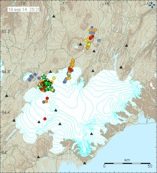
This is the earthquake activity from 20:20 UTC. It clearly shows the earthquake activity as it now is taking place. Copyright of this image belongs to Icelandic Met Office.
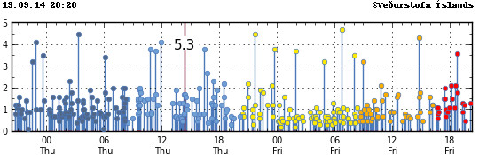
Magnitude of the earthquakes taking place during the past 48 hours. Copyright of this image belongs to Icelandic Met Office.
Update Saturday 20-September-2014 at 13:16 UTC
- Largest earthquake since midnight was an earthquake that took place at 01:10 UTC and had the magnitude of 5,1.
- Eruption at Holuhraun continues same as before. The central crater is now high above the flat desert that is in this location. I don’t know how high it is now.
- SO2 pollution have been noted over Iceland today. It has been seen in Reykjavík, Borgarnes, Akranes and other places. The amount of SO2 in this places is far below health risk levels according to the news.
- Minor earthquake activity continues in the dyke and has extended slightly more south since yesterday.
- GPS data continues to be confusing. GPS data from Icelandic Met Office can be found here. GPS data from University of Iceland can be found here.
Update Sunday 21-September-2014 at 14:35 UTC
- The eruption continues as before. There is no major change taking place in Holuhraun.
- Largest earthquake since midnight is a magnitude 5,5 earthquake that took place at 10:51 UTC. Other earthquakes have been smaller. This is the second largest earthquake since activity started in Bárðarbunga volcano. With the largest earthquake so far taking place on 26-August-2014 having the magnitude of 5,7.
- People have found going into the closed area and that is illegal. This is dangerous since there is high risk of new eruption taking place under the glacier south of current eruption. When that happens the glacier flood is going to coming down to the current erupting area within 30 to 60 minutes (1 hour). That is not enough time to send warning to all the people in the area. If you want to go to Holuhraun, rent a plane. Its the safest option at the moment. Don’t go by car! Small eruptions have been taking place under the glacier in past month. So we know they are happening, they have not been large at present time, but that is going to change without warning. There is also high risk of gas like SO2, CO, CO2 from the eruption.
- Dead birds have been found close the lava field in recent days or weeks. I don’t know why this happens, but it is clear that deadly SO2 gas and other gases are killing the birds.
- There is a storm in Vatnajökull glacier area today. As can be seen on Icelandic Met Office wind map here.
- Eruption in Bárðarbunga volcano is expected to take place without warning. It has not yet happened, but the chance of an eruption taking place is higher than it won’t happen.
- Bárðarbunga volcano caldera continues to subside. Latest drop was around 25 cm following the magnitude 5,5 earthquake.
I am going update this later today if there is reason to do so.
Article updated at 13:16 UTC on Saturday 20-September-2014.
Article updated at 14:38 UTC on Saturday 21-September-2014.
Article updated at 14:41 UTC on Saturday 21-September-2014.
Looking at cam#2, I do now see (off to the right) what looks to be a new area that is flaring up. It is small or far away. Not sure if this is a new spot of eruption or if it is just a flare up of an old part of the fissure. I would like one of the steady watchers to comment, and have a look.
Nothing new to see…
I had a similar thought, but it turned out to be the reflection of my spectacles on the screen! Doh!
Cam 2 has started moving and zooming, I like that. Much better than the close-up some days ago (and certainly much better than the fog cam two days ago). I don’t think there is a new area lighting up, just the old one and a lot of smoke near the Dalek from a different perspective. But I might be wrong.
Thank you, I do not look at the cams often. I was unsure if there had been a change since the 5 above 3 EQs.
Looks like Europe is going to get a strong whiff of sulfur by tomorrow.
http://sacs.aeronomie.be/nrt/NRTimg/gome2_vcd_NRT_106_lr.gif
In the event of a big eruption… [no predictions just yet]… the jet stream forecast for the coming week isn’t looking particularly good. The UK and northern Europe could get more that just a “whiff” of toxic gases, etc.
I am more worried they moved all the sheep away over there lol
Hello Jon
I just had a look at your webicorders. Is that tremor on Heklubyggð from about 1900, or is it just some sort of noise?
There is a increase in wind noise. Storm is expected to take place tomorrow in western Iceland.
I saw a beautiful creamy orange sky on the cam.
Looked unusual to me.
Here’s the latest MODIS image of the eruption site.
https://earthdata.nasa.gov/labs/worldview/?switch=geographic&products=baselayers,!MODIS_Aqua_CorrectedReflectance_Bands721,!MODIS_Aqua_CorrectedReflectance_TrueColor,MODIS_Terra_CorrectedReflectance_Bands721,MODIS_Terra_CorrectedReflectance_TrueColor~overlays,Reference_Labels,Reference_Features,Coastlines&time=2014-09-11&map=-18.234375,64.033447,-14.516602,65.773682
Just copy and paste into address bar. Link didn’t work right for some reason. If it brings you to the 11th, just click the 20th on the map date bar.
When a eruption starts under a glacier the SIL stations go crazy on the harmonic tremor level. So far, that has not yet happened. Smaller eruptions do create the same tremor, but at lower levels. Since the amount of harmonic tremor is related to the size of the eruption taking place.
Moving and zooming has stopped, too bad. The close-up is too grany, but still much better than the fog-cam two days ago.
Aaarg, this was meant to be a reply to my previous comment. Is it possible that the commenting system forgets which comment you want to reply to if you entered a wrong captcha or Anti-spam test once?
Yes, that is a possibility. If you register then you don’t have to enter captcha test and the math test.
I have to keep the spam bots out, even if I have this difficult tests they still manage to get into my comment system once in a while.
Jon,
Are you aware of the WordPress anti-spam plugin Akismet – as a personal blog you seem to meet the conditions for free use. It very rarely makes a mistake as it uses a central database of spammer IPs and email addresses. It’s also written by Automattic (the company behind WordPress).
With it activated you can turn off captcha, maths test and no longer need to manually validate a first time poster (unless you want to). It typically has a success rate of about 99.9%, in my experience, detecting spam.
Of course you may have reasons why you don’t want to use it but I thought I’d mention it in case you’re not aware of it.
Yes, I got that. The problem is that plugin alone is just not good enough. Spam bots today pass it without a problem. So I had to add new layers to the protection.
Activity seems to have increased significantly this evening, even compared to other pulses that occur every 1-2 days, how does this compare to historic eruptions and is there a threshold after which the caldera will no longer contain the upwelling of magma??
Jon
Have a look at the HUS tremor, it looks like it went up really fast
Hello Jon, I am a forero Spain we are following from volcanoes forum Bardarbunga developments.
there is the probability of collapse of the caldera?
thank you very much
There is an uplift currently ongoing in the Bardarbunga. Caldera surface, for once I believe it to be a genuine GPS reading , magma and gas on the increase following last 3 large EQ’s.
Signs should be showing within next half hour at fissure eruption, results should allow us to determine a better understanding of which phase we are at in regards to what happens next.
I don’tknow about uplift but things are certainly livening up
Fissure seems to be very active or is it just my imagination lol watching on a different stream from the normal one
Not your imagination, it is more active. The left hand fountain is erupting more frequently and the right hand one looks like it’s going higher. So more volume than previously.
Looks like we are getting more follow on EQ clusters today, that’s based on looking at the quake chart at base of Bárðarbunga GPS chart here
http://hraun.vedur.is/ja/Bardarb/BARC/
I am watching live on cam#2 and the fissure eruption seems to have slowed way down. I am not sure if this normal at this stage or if I am seeing something very strange going on. I am hoping one of the people who watch often will take a look and tell us if this normal or what!
I am new here and was watching at the same time. The eruption seemed to fade away for a few minutes but has sparked back up again now. I too did wonder if there was significance to this?
Just to say that I am new to posting here – I have been watching the cams, charts, Jon’s blog and all the comments here for days and days and days. Fascinating (and addictive!)
I still see lava coming out of the cauldron but no large fountains.
Which camera are you viewing?
That’s certainly not the case from this camera
http://www.livefromiceland.is/webcams/bardarbunga-2/
I saw the fountains fade about 10 mins ago on this cam for a short while – I now wonder if the gas cloud obscured the view for a short while perhaps??
Biggest fountains I have seen just now on above camera.
The eruption has returned to normal, sorry my error! But, as I watched a few minutes ago, it did fade out quite a bit.
I had only just started watching about 10 minutes ago, so could have missed it when it slowed. I think gas from eruption can obscure the fountain sometimes.
This is far better than watching the TV over here in the UK.
I dont think the area has been this active since the fissure opened, the quakes then however were not this large! I find it concerning this coincides with (excuse my terminology) fresh magma emitting from fissure. It seems the magma plume is now pumping from the deeper areas, alot of pressure is being generated in this event.
I think the newly formed *hot* and *fragile* little brittle volcano walls shield some of what we see, and incidentally some parts of it collapse or break down to give way to the lava fountains and lava river. This gives the impression of fluctuations in strength, but actually it just keeps pumpin’ almost same amounts of lava.
Im watching the left hand fountain, it’s getting higher as I have watched over past 10 minutes. Since the eruption started I have also monitored how frequently the fountain rises and falls and it seems to be getting more frequent.
This could be what we were seeing, but not sure. Things got very quiet for a short while.
Hi there im just a noob but keep on watching because I just love geology from when I used to live in the Shetlands. But can I ask could the collapse of bardabunga be due the rift between the two plates. I see it as the 2 plates are pulling apart and barda is caught in between. The north of barda is pulling west and the south is pulling east, causing the volcano to pull apart which you see in a north south divide and collapse.
Ian, I’m near Edinburgh.
That’s how I see it, most of the quakes at the craters edge are either on the north-north-east or south-south-east walls or ie appears to be at right angles to the rift at that point. Lets say the volcano is at a complex offset in the rift and now with deep magma entering the system.
Wind direction in scotland has started coming down from north west today so hope it dont erupt just now!
Me toochyper al, I’m in Leith and I am off to Loopallu on Thursday whic is a s close to Iceland that I will get this year!
We have some huge plumes of lava right now!
Yes, best display I’ve seen, makes up for all the low cloud the past nights.
It’s like milk boiling over the edge of the pot 🙂
Based on all the EQ’s in the plumbing of BB I’d say that the chances of eruption are rising by the hour. That and the fact that the nearby stations all show harmonic tremor indicate that, although things may appear quiet, there is a lot going on according to the instruments. Also southern neighbour Grimsfjall seems to be showing signs of increased activity. It will be interesting to see what daybreak brings, or perhaps we are just seeing BB tossing in it’s sleep.
It’s really coool!!
Im going to suggest the left fountain looks a lot whiter at it’s base than is the past, so maybe the lava temperature has risen thus making it more fluid and easier for the fountains to go higher.
Fountain does seem higher, or has part of the ‘volcano under constuction’ collapsed? (not Bardarbunga before anyone gets excited)
That sounds like a good reason. It’s difficult because we are so far away. I watched a youtube video the other day from a link posted on here and it showed the scientists vehicles in front of the fountain, the scale of this eruption is awsome.
I think you may be correct about a collapse, it could be the mouth of the current crater, where the lava is flowing out has widened, maybe because of increased volume of lava erupting.
Just a thought… i have them now and again! 🙂
I have just had a look at some B2 screen grabs from 07/09/2014 and the current eruption, although spectacular tonight, doesn’t look as big nor as bright white as then. Obviously there are variables such as mist, dust and stuff that will be different. Who knows, it’s webcams from a very long way away…..ultra cool though and amazing to see!
Lava has been erupting out of the cauldron very fast. It seems that it is being ejected out at a much faster rate that an hour ago. Wow, if only I could be up close and personal to see all the action!
Sounds a bit hot!
Seems to be flooding out of the right hand side now.
It’s 01:42 I’m heading to bed!
Enjoy the show all.
Still more eruption intensity than yesterday, I think.
The lava fountain in the biggest crater is rather white in the center. Heat? Different mixture of gases?
Would be great to get an explanation of why the GPS data is confusing, is it not doing what scientists thought it would do according to all the different scenarios?
Thank you for keeping the blog going!
Yes, I am sure the scientists would like such an explanation, too. It looks to me like the entire area around the volcano is inflating, but unevenly. Some places are inflating more than others.
Looks like the lava is flooding out of crater now. A flash lava flood.
What’s the best YouTube site now? My old one is no longer live.
Thanks for pointing that out. Have just found this one, but is it live?
https://www.youtube.com/watch?v=_tASvZFxI5U
A long shot but would it be plausable the water from lake Kleirvatn when it partly drained quite a while ago has (eventually) resurfaced at Gunnuhver mud spring in the form of that new mud geyser?
No, I don’t think so. Kleifarvatn is too far away from Gunnuhver.
Also, as far as I remember, the water in Gunnuhver is – anyway mixed with – seawater – , not in Kleifarvatn.
Just a thought, i know water can travel underground large distances using faults. In Somerset we have the only geothermal water in Britian, this water fell as rain on the Mendip Hills around 10,000 years ago. It rises via the Pennyquick fault in the city of Bath as geothermal water (also as a warm spring at Hotwells in Bristol).
Just thought the mud geysir at Gunnuhver had something similar! After all, the water from the lake must’ve gone somewhere!
Water would also find its shortest way to the sea and Gunnuhver is a long way to the west (about 30 km), the shortest way from Kleifarvatn to the sea is just about 5 km to the south.
See eg. here:
http://atlas.lmi.is/kortasja_en/?x=562665.7353314705&y=495556.2611125223&l=2&anno=1&bm=3
Both are on the peninsula of Reykjanes in the southwest of the country. Kleifarvatn is indicated if you enlarge, and Gunnuhver is very near Reykjanestá.
BTW both belong to different volcanic systems, ie. Gunnuhver to the volcanic system which has the same name as the peninsula, Reykjanes, and Kleifarvatn belongs to the Krýsuvík volcanic system.
The faults of these volcanic systems on the Reykjanes peninsula are arranged parallel to each other. The water would follow the fault lines.
See also http://isor.is/jardfraedikort-af-sudvesturlandi
I am seeing strong earthquake coming on my geophone when I write this. It appears to be above magnitude 5,0.
USGS has it at 4.4
M4.4 – 112km SSE of Akureyri, Iceland
2014-09-21 00:57:52 UTC
http://earthquake.usgs.gov/earthquakes/eventpage/usb000sem4#summary
and the caldera does drop again..
And rebounds. It’s all over the place after these quakes.
http://hraun.vedur.is/ja/drumplot/dyn.png picked it up …
Some nice aerial footage over Holuhraun eruption @ YouTube.
Here
Thanks for the link. The rivers of lava are interesting feature. I also noticed that they are huge and the central crater is massive, both in length and hight.
My pleasure, and I noticed the same features plus the huge volume of lava, just phenomenal.
Excellent video!
+1
Wish they had shown the interface where the lava meets the river.
I thought we would finally get to see the Svarta waterfall as they raced down the lava flow for its full length. As the time ran out I yelled at my tablet with frustration. Then I went back to pause the playback at the end for a tantalizing glimpse.
Really amazing to see just how much lava this eruption has already produced. It covers a huge area!
At one point they said the eruption was producing the same flow as Niagara Falls. Now imagine the flow of the Niagara River for this entire time and how much that would spread over land.
Wow. Just…wow. That is mindblowing. The webcams give the impression that the fissure is a long relatively thin line, but looking at this it’s like the whe countryside is erupting.
Thanks for sharing…i think I must look for money to make a trip to Iceland…
That is an amazing video, it really shows the scale!
Do they have a word in Icelandic for someone who is addicted to watching volcanic eruptions?
Jón, maybe you can think of a word, it would be well used on this thread and would spread fast! and you would be honoured with its creation.
I’m becoming an addict, look just had 6 hours sleep and I’m back watching.
The people in that helicopter are certainly addicts, did they think about what they could do if they had to land that helicopter in an emergency, well no, because they are eruption addicts! Well they are certainly adrenalin addicts!
its a bit different view than the “flat” view from cam1 or cam2. The scale of eruption impact is huge. Thanks for sharing
Fabulous footage. Really makes me appreciate the scale of this, which can sometimes be lost after hours watching the mila cams
Thank you for that link!
Wonderful to watch.
Earthquakes seem to be clustering to the NW of the caldera, both inside and outside the rim. Has magma found a new way out of the chamber and begun to form a new dike?
If the GPS signal is that noisy, they should put two or more units together and average the result. Random noise from ice and such would tend to cancel while actual movement would be readily seen from the average. It isn’t likely that noise from ice on the antenna would cause both or all three units to move in exactly the same direction at the same time.
A lot of GPS error is from external sources, so two units nearby one another would show very similar error. If it weren’t for this, the whole theory of DGPS (differential GPS) would have to be thrown out. The best way to get rid of the error is just averaging the signal over time, which is why the 180-minute moving average is the only thing worth paying attention to on that graph.
I am not talking about the usual noise, I am talking about the noise that starts every night at about 18:00 and lasts to about 07:00 the next morning. This seems to be something very local to the units and not related to GPS itself. It also varies. On the cooler, wetter evenings, it is much worse. Example, last night was worse than tonight and the night before that when they likely had freezing fog even worse still.
Someone should design a heated GPS aerial to keep the ice off.
And a power point to plug it in, on the glacier, miles away from anywhere 😉
There have been about 5 deep earthquakes at Habunga (Katla area) this month. From the IMO list today:
1) 21.09.2014 /0:10:47/63.641,-19.055/19.0 km/0.3 magnititude/90.01/7.1 km NNE of Hábunga
2) 20.09.2014/05:24:28/63.633,-19.064/25.9 km/1.1 mag./99.0/ 6.1 km NNE of Hábunga
3) 20.09.2014/05:21:41/63.635,-19.040/22.4 km/0.9 mag./99.0/6.8 km NNE of Hábunga
The other 2 were ~17 km and just under 30 km depth, within the last 30 days, I believe. Wish I had copied these as well.
Okay, maybe I don’t want to get too close! Thanks for the link. This fissure is amazing with the huge plumes and river of lava running for a very long way to the river.
So worried about the people and animals in Iceland. I do hope the emergency plans are firmly in place. I would feel so worried if I lived there right now. I do hope that whatever happens will not ruin their lives and their livelihoods. It’s such a powerful force and there isn’t anything that can be done to stop it.
Seismicity uptick, 5+ just took place
I see only a little swarm in the depth 1,1 km (M 0.8, 1.9, 2.4)
probably you are right, EMSC:
Magnitude mb 4.3
Date time 2014-09-21 09:36:44.8 UTC
Location 64.60 N ; 17.80 W
Depth 8 km
I don’t know because IMO check the quakes above 5 before publishing them and that takes time, especially on Sundays. It may be added later.
Great site Jon
This now rather dated map shows the subsidence of the caldera. However, it seems to also indicate that the far northern(east) section was actually ~4m higher (whilst the rest of the caldera was subsiding)
http://earthice.hi.is/bardarbunga_subsidence_new_data
There has been a focus of seismic activity in this area of the northeast (and most recently, seems a little beyond the northern edge) of the caldera.
Are there any more up to date measures of whether that particular section of the caldera in the northeast (and perhaps area beyond to the north) is inflating?
Quake verified by IMO as m4.5
Whats on cam1 at the moment looks like a big weather balloon or something
Look at the Jóns webicorders – huge eq, maybe M5,5+!!!
emsc 5.4
That’s a big eq. 5.4 reported at 10km from GFZ via my EQInfo app.
BB gps -25cm at the same time of the EQ!
So since early Saturday morning there’s been around 24 quakes above magnitude 3. And several strong fours or fives. And now a biggie again. I think whatever was blocking it previously is now showing less resistance. My gut feeling is that a new fissure is going to appear in the NW of Bard.
big drop on BB GPS as well
http://hraun.vedur.is/ja/Bardarb/BARC/
Could that be the largest EQ yet from the crater? confirmation required.
5.5 imo confirmed
grim and hus tremor gowing up
EMSC reporting it as a 5.4 at 10km depth but many km’s south east from BB, error in location ?
Forget EMSC, only use IMO as they have more kit to give the accuracy.
Wow. New quake confirmed at 5.5
Ouch!
I have been wondering why the quakes seem to be getting larger, we’ll probably get something visual soon. Liked the video DaveM posted a link to.