
This information is going to get outdated quickly. This is also a Friday update and that means I won’t write new articles during the weekend. I am just going update this one with latest information. New article is only going to be written on weekends if something major happens in current activity in Bárðarbunga volcano.
Current status of Bárðarbunga volcano at 23:43 UTC
- Largest earthquake so far today has had the magnitude of 4,7 at 06:44 UTC. Other earthquakes have been smaller, but several magnitude 3,0 – 4,3 earthquakes have taken place today. More information can be found at Icelandic Met Office website here.
- GPS data [University of Iceland GPS data can be found here) still makes no sense to me currently. I am hoping to figure that out in next few days what is going on there.
- Landsnet that takes care of the electric grid in Iceland has started to move backup items for its power-lines in south and north Iceland. In the case they need to do a sudden repair to them if they take damage in glacier flood. This are 220kV power-lines and stations that are at risk from glacier flood due to eruption in Bárðarbunga. I don’t know about the dams them self if anything is being done to protect them.
- The eruption in Holuhraun continues as it has been doing for the past few days. Now there is mostly one crater erupting.
- Chemical mixture of the magma has changed. It is now coming from deep magma chamber at more than 10 km depth. This means the eruption is going to be long lasting.
- Scientist expect to be at Holuhraun eruption until December at least.
- South part of Bárðarbunga fissure system have not yet started to move. When that changes is impossible to know.
Map of earthquake activity for the past 48 hours
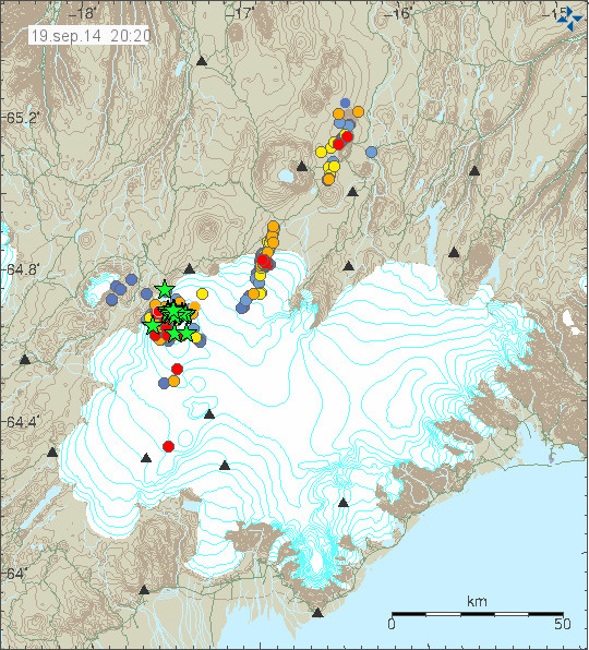
This is the earthquake activity from 20:20 UTC. It clearly shows the earthquake activity as it now is taking place. Copyright of this image belongs to Icelandic Met Office.
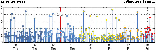
Magnitude of the earthquakes taking place during the past 48 hours. Copyright of this image belongs to Icelandic Met Office.
Update Saturday 20-September-2014 at 13:16 UTC
- Largest earthquake since midnight was an earthquake that took place at 01:10 UTC and had the magnitude of 5,1.
- Eruption at Holuhraun continues same as before. The central crater is now high above the flat desert that is in this location. I don’t know how high it is now.
- SO2 pollution have been noted over Iceland today. It has been seen in Reykjavík, Borgarnes, Akranes and other places. The amount of SO2 in this places is far below health risk levels according to the news.
- Minor earthquake activity continues in the dyke and has extended slightly more south since yesterday.
- GPS data continues to be confusing. GPS data from Icelandic Met Office can be found here. GPS data from University of Iceland can be found here.
Update Sunday 21-September-2014 at 14:35 UTC
- The eruption continues as before. There is no major change taking place in Holuhraun.
- Largest earthquake since midnight is a magnitude 5,5 earthquake that took place at 10:51 UTC. Other earthquakes have been smaller. This is the second largest earthquake since activity started in Bárðarbunga volcano. With the largest earthquake so far taking place on 26-August-2014 having the magnitude of 5,7.
- People have found going into the closed area and that is illegal. This is dangerous since there is high risk of new eruption taking place under the glacier south of current eruption. When that happens the glacier flood is going to coming down to the current erupting area within 30 to 60 minutes (1 hour). That is not enough time to send warning to all the people in the area. If you want to go to Holuhraun, rent a plane. Its the safest option at the moment. Don’t go by car! Small eruptions have been taking place under the glacier in past month. So we know they are happening, they have not been large at present time, but that is going to change without warning. There is also high risk of gas like SO2, CO, CO2 from the eruption.
- Dead birds have been found close the lava field in recent days or weeks. I don’t know why this happens, but it is clear that deadly SO2 gas and other gases are killing the birds.
- There is a storm in Vatnajökull glacier area today. As can be seen on Icelandic Met Office wind map here.
- Eruption in Bárðarbunga volcano is expected to take place without warning. It has not yet happened, but the chance of an eruption taking place is higher than it won’t happen.
- Bárðarbunga volcano caldera continues to subside. Latest drop was around 25 cm following the magnitude 5,5 earthquake.
I am going update this later today if there is reason to do so.
Article updated at 13:16 UTC on Saturday 20-September-2014.
Article updated at 14:38 UTC on Saturday 21-September-2014.
Article updated at 14:41 UTC on Saturday 21-September-2014.
Amazing updates Jon. Thanks for the dedication you put in. It is very appreciated.
Thank you Jón, for the interesting update. 🙂
It also seems that the firms working with the power stations (esp. Landsvirkjun) have been collecting informations about the developments from the beginning. There is eg. a news video from 22. August with a spokes person of the firm. And they say that they were yet at this time releasing water from the nearest reservoirs (esp. Hágöngulón) into others, so to make room for water entering the upper ones. There are also some small emergency dams which are constructed especially to let them go / be destroid in case of a jökulhlaup.
http://www.visir.is/tappa-af-hagonguloni,-karahnjukar-ekki-i-haettu/article/2014140829630
One of them it seems would be directing part of the flood water into a nature reserve called Þjórsárver; people from the resp. supporting society protest against this.
http://www.thjorsarverfridland.is/?p=520
Hope yah don’t mind Jon but i will leave a link to an excellent introduction Documentary to Iceland Volcano’s and Glacier(s). Extremely insightful for people new to this area and some amazing archive footage and some island history etc. http://www.youtube.com/watch?v=sa-DdSPya2E
Looking at cam2, there seems to be a purple glow around the erupting magma. Is this simply an optical effect or does this have something to do with the chemical composition of the magma an gasses released?
Seems to me to be just glare on the camera.
Jon your take on last EQ swarm from 7.5 km up to surface on NE flank of caldera? the strain from the weight of glacier is showing its hand, collapse there most likely and possibly sooner than we all thought.
Good work Jon,
What are your thoughts regarding the swarm being fed from below? until about 10 days ago, bunga showed clear push pull affects on the swarm (quake activity along the dyke SW & SE in response to bunga’s large quakes). Now (and for the past 10 days) this cycle is no longer observed, what we now see is activity rising vertically in both bunga and swarm at the same time… The only plausible explanation i can put for this is, the swarm has eaten through to the direct source that also feeds bunga…. this would also explain why the magma is now fresh and that there is no lateral quakes along the dyke..
“Chemical mixture of the magma has changed.”
I wonder if you have a link to this? Has the composition been more or less constant so far?
GPS movements from surrounding stations is so small, and fraught with error that one could only say that movement is pretty stable. Slight flexing from magma intrusion is what is going on here I believe. Stations near Big B still seem to show very slow movement in that direction as the volcano sinks, but overall, steady as she goes at this point.
M5.0 a few minutes ago, according to USGS.
5.0 magnitude at emsc website 64.73 N 17.13W 10 km deep
Yup, shows on Jon’s webicorder
Big drop on GPS subsidence graph too
Yeah, big boy.
3dbulge is sleeping – where is the m5?
3dbulge will only show it after it appears on IMO website. They are probably manually verifying it, so the big ones are sometimes slower to appear.
Burning very brightly – may be camera flare, but it is the first time I see a purplish colour where it burns. Could there be a different gas? Or is it really only camera flare. Far less yellow in the flames than usual. Maybe it has no significance.
hen
ICELAND
Magnitude: 4.8
Depth: 10 km
Time: Sat, 20 Sep 2014 01:10:14 http://www.oe-files.de/gmaps/eqmashup.html
Magnitude mb 5.0
Region ICELAND
Date time 2014-09-20 01:10:15.0 UTC
Location 64.73 N ; 17.13 W
Depth 10 km
Distances 232 km E of Reykjavík, Iceland / pop: 113,906 / local time: 01:10:14.9 2014-09-20
107 km S of Akureyri / pop: 16,563 / local time: 01:10:00.0 2014-09-20
http://www.emsc-csem.org/Earthquake/earthquake.php?id=400653
What is the black wedge moving right to left across Mila 2? Fog?
Sorry, I mean Mila 1.
Looks like more ice on the GPS again. Seems to be hitting every night lately. 🙁
This is autumn in Iceland and it’s highlands and mountains in the interior where the climate is a lot more fierce than near the coast.
That is a lot of smoke in the back ground on Bardarbunga 1 cam. I’ve been watching since the onset, what is that huge plume?
It might be steam I am trying to see how far away it is, we don’t know where the lava has travelled over the last few days.
Mila 2 doing panoramic sweeps now
Ref “ohnoes112” post at 2.02am….
I have watched the video and very interesting! If you want to skip the history bit, the action starts 40 minutes into the youtube video. When Jon talked about glacier outbursts and icebergs as big as 5 storey houses, he wasn’t joking !! Check it out !
Yes, the flood is something else. The Policeman was very lucky.
First class video. Great to watch, makes you sit back and think.
Scientists have arrived
Hopefully not taking R2D2 with them. Looks like at the moment.
Interesting that there are a couple of small quakes further under the glacier today.
Bardar 2 is moving!! Panning left and right.
Forgive my excitement, I feel like we have been given a present.
Looks like I have a new tv channel to watch, waiting for the mist to clear for a pristine view. 😀
It looks some tourists with a weird shape caravan have got lost !
Is the eruption getting stronger ? The smoke plume seems to be getting higher ?
Maybe not so much wind???
Looks a bit like higher gas concentrations near ground when the camera is to the left of the car and the radar. Time to get people out there?
May i share some thought about the caldera subsidance data with you?
After every quacke we see a drop, followed by a period of random spikes / shakes.
What might be happening here is: the ice of the glacier setting to the new change in the caldera floor. Over time, this floor gets more and more bowl-shaped. The ice reacts different to deformation then rock. It does not have big quackes, it is a slurry. After a quacke it will slowly creep towards the center of the subsidance. It does this in waves and small shocks. I think this is the random spikes we see. The GPS data come from a point sample dont they?
What this also can mean: the ice is covering up the real scale of the subsidance. It fills up the gap. There can also be water seeping down, with can even better cover up the real gap, because the ice will float on it. If there is water in the caldera, i will go nowhere then just to the deepest drop, making it unable to detect above the icecap.
Are there other kinds of measurement, like ground penetrating radar, sound waves, etc, to detect the status?
It’s because of standard GPS-failure, ice on the sensor, solar storm disturbing communication to the satellites, etc. The ice does not move 2m up and down in every 5 min in periods.
As long as the earthquakes are still moderate up toM5 we don’t need to worry too much about collapsing things. When we will see >M6 quakes things will get more serious.
I think it is more dependent on how close to this situation we are than the absolute magnitude of an earthquake.
if it should be standard noise we would see it all the time. This is not the case
>5 is not standard noise.
I think they have ground penetrating radar and used it during fly overs.
Shows that GPR is used by Iceland’s geologists:
http://all-geo.org/volcan01010/2012/01/icelands-melting-glaciers-and-other-stories/
I am not suggesting the probability of a collapse here. I just wanted to point out that what is measured is the surface of the ice, not the caldera floor. Assuming their movements are the same might be wrong.
I personally belive it will be hard for an eruption to push trough 700m of ice. The cooling effect would solidify any lava. Or it must be a sudden explosive release, but for that you would expect a bulge forming instead of subsidance.
A flank collapse might be more probable, and also without any signs beforehand.
They’ll for sure use the GPR during their fly overs and then they don’t measure the ice surface, but the botn of the caldera.
H2O + lava on any real scale goes boom. There’s no functional difference between ice and liquid water in this role, as it is 100C between freezing and boiling and the volcano is more like 1100C and actively pumping more material.
You are correct that the caldera won’t have any kind of eruption quietly.
I feel the same way. There could actually be a surface eruption at the bottom of the caldera and we would not see any indication of it on the surface except the ice dropping as it melts. Glacial ice contains a lot of air, dirt, etc. As it melts, it loses volume. Even if there is no exit path for the water at the bottom of the caldera, the ice will still lose volume as it melts.
We have seen quakes in the M2 range verified to have been only 100 meters deep and larger ones at 1km or less depth. If this is due to magma movement, we could see considerable geothermal heating of the rock at the bottom of the caldera. This will result in the potential for heating up the water touching the rock and melting ice above it. Under 700 meters of ice, the water will have a very high boiling point and there is probably enough convection to prevent any flashing to steam. It would look more like an ocean vent under 700 meters of water — not much indication of it at the surface.
That the GPS stations around the caldera are moving AWAY from it indicates to me that the area generally is still undergoing inflation, not collapse, with a couple of notable exceptions to that general movement.
I’m not convinced anyone has a handle on exactly what is going on with any certainty, they are simply looking at what is most probable.
Indeed.
Remember that Mt St Helen explosed after a M5.1 !
But Mt St.Helens is a very different type of volcano: andesitic strato volcano with an inclination to lava dome formation and destruction.
St Helens is a different animal but the rim of BB, if memory serves, shows rhyolites which are a more evolved, so they contain more silica and will be more viscous and potentially explosive lava. BB is huge, and so is the putative magma chamber, so it’s eruption history will include benign as well as explosive eruptions if I am not mistaken.
St. Helen was building a subsurface lava dome and in the process was causing a weakening of the overlying rock. When that last M5 struck, it started a massive landslide which in return caused a massive reduction in pressure on that cryptodome. There would have been a combination of fast decompression melting and immediate separation of gasses from the magma resulting in an explosive eruption. It was like suddenly removing the cap from a shaken bottle of soda water.
The last report I saw said the currently erupting magma has about the same viscosity as honey but if the chemical composition has changed to material coming from deeper, it might be thinner now. The magma from St. Helens is more like tar.
Have just been looking and playing around with the 3D map on 3DBulge and something caught my eye. All week there has been two distinct separate columns of earthquakes, clearly defined no matter how you moved the map around.
However there seems to be a third column forming in the last 12 hrs. It seems to branch off the mane BB column at about 7km deep and go off to the NW. Anyone have an explanation for this.
The 3D-bulge map is not very accurate in the positions of the earthquakes. I believe it exegurates the vertical scale. Also i belive the horizontal locations are not quite right
If you look at Jon’s map on this update from the met office it shows the same cluster to the NW. of BB so it is not just on 3DBulge.
Almost looks like something going on way back behind the cloud from the vents….
These cameras is not good enough to se such things on long distances. This forum is full of dark spots, different collored smoke, imaginary vents etc.
Someone working on R2D2
I have updated this article with new informations. There is not much new in news about what is going on. So I now have to work out myself what is going on if I can.
Thanks for the updates Jon.
From what i read about caldera coolapse and EQs is that the large quakes reduce and are replaced by many small ones until the big one
That’s not happening here now. No caldera catastrophe yet
Yes, thats next week
Thanks again Jon, good news about Landsnet
For the person commenting about it being a new tv channel I just had 4 weeks off sick and watched it everyday very addictive
That was me. I hope you are on the mend now.
I’ve been goggling at the webcams since the 16th August; but a moving, zooming camera is the best.
I can’t seem to get on the cameras now, too busy I expect. Will catch up with the comments and find another stream to view.
I am no convinced that my original theory that we were going to see the birth of a new shield volcano is going to be quite accurate after all.
I have said this a few weeks ago, even before the eruption started, as the region near Dyngjujokull and Holuhraun is full of shield volcanoes around (and not so many fissures or ridges), so I inferred that this eruption was going to result likely in a shield volcano formation. Anyways we are approaching a peak of hotspot activity, so I expect large magma-volume eruptions around Vatnajokull.
In VC blog some commenters name it Irpsitdyngja, after my name, or perhaps better that we call it Holudyngja or Baugurdyngja, to be a bit more formal name.
Dyngja means shield volcano in Icelandic. And Holu (from Holuhraun) means hole. Baugur is the name the scientists gave to the main crater of this eruption, which is now erupting alone, just like it happens in a shield eruption.
So far this eruption has already created a shield volcano of its own. About 0.4 km3 created, in form a shield structure that elevates about 100 meters above the surrounding plateau (and growing every day). A common shield eruption lasts usually many years, at a low buy steady rate, of around 4km3 or more, and usually a shield is between 250 meters to 600 meters high.
So, currently we have 1/10th of lava volume of a common Icelandic shield volcano, and about 1/3rd of the height of a shield volcano mountain. At this rate, a medium size shield volcano would be born in about two years.
Irpsitdyngja (or Holuhraun) shield volcano is being born.
This is the largest eruption from lava point of view in well over 100 years and it has not stoped yet. It is a fissure eruption with a risk of a mother volcano eruption. It just spread on a wider area. Bardarbunga does not lack lava.
In Iceland.
Jonas, it’s not the largest lava eruption in world in 100 years. It’s second biggest. Largest was Hekla in 1947, with 0.6km3 of erupted lava. While this one stands at 0.4 km3.
But interestingly it is the 3rd largest since Laki, in 240 years. After Hekla 1947 and Hekla 1845.
And it is larger than the lava eruption of Askja 1875 or in Bardarbunga in 1862-1864, which were also quite large, about 0.3km3 reported, but I think those two were pretty underestimated.
Been seeing quite a few low mag EQ,s listed at depth of 0 km, how is this possible. Is this the ice settling.
Yeah, all those shallow quakes today at less than 1km depth must mean something…
I just got a harmonic tremor pulse on my geophone in Heklubyggð, it also appears on the nearby SIL stations that IMO has. It was followed by magnitude 3,7 earthquake and soon after a magnitude 4,5+ earthquake. I don’t think this means anything good. But I am waiting on details.
Yes, that was an unusual sequence of quakes. Was actually 4 quakes in quick succession. Something gave out!
Ooh, is another biggie occuring? Something showing on DYN drumplot.
Another M 3-4 quake http://hraun.vedur.is/ja/drumplot/dyn.png
Wow, lots going on under BB, what gives?
That’s 5 quakes of growing magnitude in 15 minutes… Most recent one looks m4+?
My belly is telling me something is going to happen. 🙂
Been waiting weeks for this. It had better not clash with Doctor Who!
Haha, in this case Doctor Who hasn’t got a chance! Record it!
Apprehensive but excited wow keep safe guys
some recent quake are north of the caldera and a m3+ just out of the glacier, new dyke forming from barda magma chamber?
6 quakes above mag 3, and three of the above mag 4 in the last little while.
actually more quakes have been checked so now we have 8 above mag 3 in the last while, with one being a 5.0
The scores are in:
3.4
3.6
4.0
4.4
5.0
In that order in under 15 minutes. Most unusual sequence.
At least one of those events was above current dyke. But I think also a there is a possibility that magma is looking for a way up in Bárðarbunga volcano slopes (that are under the glacier). It has happened once and it might happen again, if it has not already done so.
Big B really quaking today. IMO should set up another cam somewhere focused on this volcano. Her time might be drawing nearer than we think.
Technically, Mila cam 1 *is* focused on “Big B.” It just happened that the rift eruption started between it and the main caldera in the distance. If it goes off, you’ll see it (unless it’s so big that the shock wave wipes out the cam).
A new location to the W or SW away from the current eruption would be better. The weather being created here blocking view of the caldera. A small eruption of Big B wouldn’t necessarily cause this eruption to stop immediately, so the view would be blocked quite a bit.
Lots of EQ’s in the last while in the BB system which indicates something is happening. It may just settle down, or a flank eruption may ensue, but this is all below the caldera, which indicates possible trouble ahead. I’m going to guess magma is rising and the ring faults are slipping under the strain. The deeper quakes would likely be new magma moving in to the BB magma chamber.
I see nothing on the cams at this time. That series of EQs was just unbelievable! What is going on?
Thanks, Hans Mohr for that insight. I guess we will just have to wait this out and see what Jon can come up with.
Did someone check on where the quakes of this series were?
I think it is also important to see that there is strangely no real pattern discernable. On the contrary it seems as if the quakes would be “hopping” from one part of the caldera to another (IMO data):
ENE – > SE ->SSE – ->NE -> NNE
And the depths: Something mounted from around 8km depth up to next to the surface (1.0 km). An intrusion?
Perhaps the next quakes are indicating a different event between 8,4 and 7 km. Reaction of a magma chamber?
17:00:56|64.671| -17.403|7.7 km 3.4 99.0 6.8 km ENE of Bárðarbunga
17:04:48|64.616| -17.475|4.8 km 4.0 99.0 3.7 km SE of Bárðarbunga
17:05:47 |64.611| -17.496|1.0 km 4.4 99.0 3.6 km SSE of Bárðarbunga
—- ?
17:11:41 |64.675 | -17.472|8.4 km 5.0 99.0 4.7 km NE of Bárðarbunga
17:18:46|64.682 |-17.496|7.0 km 1.6 99.0 4.9 km NNE of Bárðarbunga
Ok, I see that there is a slight contradiction in my last comment, in the end I think I saw sort of a pattern.
What is your opinion about this pattern?
I see the eastern direction of this EQs. Some days ago there where more in the south and north, perhaps it’s now the eastern rim of the caldera, which follows. But Some EQ seem also north-west outsid the caldera. I don’t know if I see this correct.
Almost no quakes in Holoraun dyke latest hours. Is the magma leaving Bardarbunga in a different direction?
No quakes also can mean: free magma flow from below to surface… as the eruption goes on at steady rate at the moment, probably magma finds a free path and doesn’t have to ‘break’ through solid rock, but uses the now existing free paths.
Or… the magma is becoming more viscous, and the current routes to the surface are beginning to become clogged. This would increase pressure within the “system”… hence the large EQs @ Barry.
Does any one know of an example where a caldera collapsed and which then induced an eruption?
I don’t believe in that concept all too much.
Not a collapse that wasn’t preceded by a fairly large conventional eruption first that caused a very fast emptying of a large magma chamber. Don’t know of one where an eruption STARTED with a caldera collapse, that is usually the end stage of a large eruption sequence.
The caldera is there because of a previous event erupted enough material fast enough that the top of the mountain fell into the chamber. It might be trying to rebuild a “resurgent dome” in the caldera or magma might be creeping up the sides of the caldera along the interface between the broken up fill and the solid rock along the edge. That is another rather common scenario, a ring of eruptions around the edges of the caldera isn’t all that uncommon.
BUT — Iceland is a unique place geologically. We have a rift zone, a triple junction, and a mantle plume hot spot roughly centered directly under BB. It would be like placing the Hawaii hotspot directly on a rift, maybe Nyiragongo in Congo is a better analogy.
(Ref: http://www.rochester.edu/news/show.php?id=3336 )
Not a caldera but a crater, same idea basically –
http://www.wsj.com/video/kilauea-volcano-crater-collapses-in-time-lapse/A6FC6F4C-D894-401B-869B-C3A607D5B12F.html
Its a bit clearer on yt –
https://www.youtube.com/watch?v=TjLtt2yvJLs
I guess it sort of depends on the structure of the volcano. Bárðarbunga is a stratovolcano, and we can’t really see that it’s 2,009m tall [6,591ft], as the entire volcano is below Vatna Glacier. As crosspatch has indicated… these type volcanoes typically experience a caldera collapse only after the initial eruption.
On the other hand there is a type of volcano that is a caldera by its very nature (typically due to its extremely large size), and these tend to begin and end with a caldera collapse event [think Yellowstone].