
This information is going to get outdated quickly.
Current status on Bárðarbunga volcano at 20:36 UTC
- Largest earthquakes in Bárðarbunga yesterday (17-September-2014) was a magnitude 5,2. Largest earthquake today (18-September-2014) was a magnitude 5,3. Other earthquakes have been smaller.
- Bárðarbunga volcano caldera continues to drop. When the magnitude 5,3 earthquake happened today at 14:21 UTC the caldera dropped 20 – 30 cm.
- GPS data (more GPS data can be found here) suggest to me that the dyke at Vonarskarð might be getting ready to erupt or getting re-activated. It formed in the first two weeks when current activity started in Bárðarbunga volcano on 16-August-2014. It is already there, it however failed to start an eruption, but as I say, it might be getting ready to get active again. This has been followed by some minor earthquake activity. There is however a more complicated picture into this. The details can be found later in this article. [Please note that due to licensing issues I only link to the GPS data. This means that data on the link is going to get updated in next few hours and are going to look different from what I have written about them now.]
- The eruption in Holuhraun continues as before. There has not been any view of the eruption for the past two days due to fog. So I don’t know for sure what is happening there.
Harmonic tremor data
I can see two things in the harmonic tremor data. The pressure is increasing in Bárðarbunga volcano system. I am also seeing pulses of harmonic tremor and that is not good. It means that magma has somewhere found a path to the surface, it just isn’t there yet, but it is working way up. It is impossible to know if this magma gets all the way up or not. Small eruptions are also not impossible, since there signature might simply be lost in the noise on the tremor plots that I am using from Icelandic Met Office.
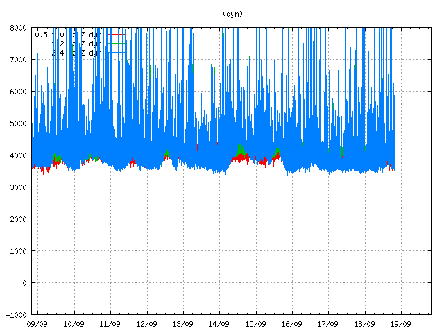
Tremor in Dyngjuháls SIL station. Copyright of this image belongs to Icelandic Met Office.
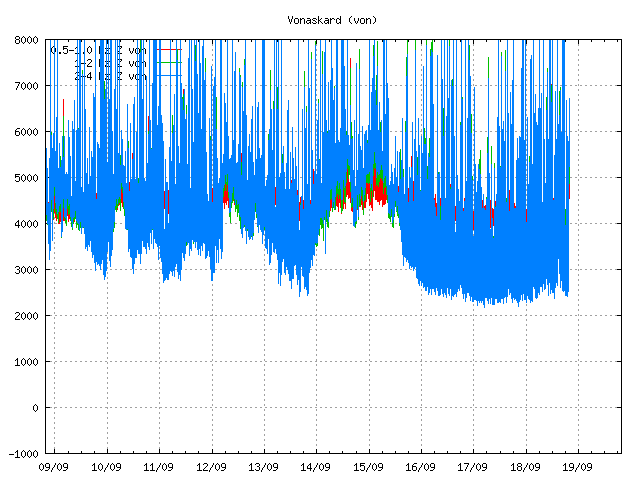
Tremor on Vonaskarð SIL station. Copyright of this image belongs to Icelandic Met Office.
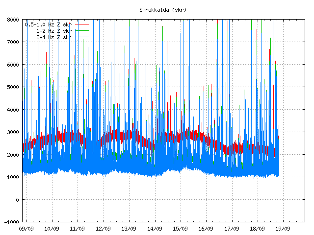
Harmonic tremor as it appears on Skrokkalda SIL station. Copyright of this image belongs to Icelandic Met Office.
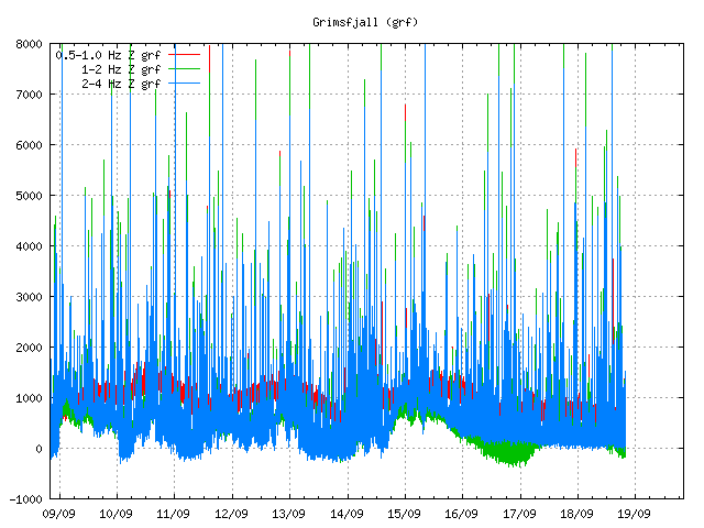
Harmonic tremor on Grímsfjall SIL station. Copyright of this image belongs to Icelandic Met Office.
Current status on the cauldrons
According to the news that I have heard some of the cauldrons that are in Dyngjujökull (south of Holuhraun) are still getting deeper. This suggest that there is still a lot of warm under the glacier that is melting the glacier. No glacier flood has happened due this. I don’t know if any new cauldrons have formed in recent days. Most of the cauldrons are located above the dyke, few are located above Bárðarbunga volcan in its slopes.
Tungafellsjökull volcano
I am seeing in the GPS data that Tungafellsjökull volcano might be getting more magma inflow. Since it appears to be inflating. This has not been confirmed so far. Currently there is nothing to suggest that Tungafellsjökull volcano is going to erupt at this point in time. It might simply be responding to the all the noise that Bárðarbunga is making at the moment, along with stress changes in the crust. If it erupts, it would be first documented eruption in the past 8000 years at least (maybe longer).
Next update is going to be tomorrow or sooner if anything major happens. It is possible to watch my webicorders here. They are updated every 5 min.
Article updated at 21:05 UTC.
Article updated at 21:14 UTC.
Morning all well it looks like that we got another fall with the 5.4 quake yesterday, the way I look at this you can see a trend within the chart. As Andy W has said you should not spend all your time glued to looking a the 3 hr MA and thinking if it goes up or down there is an earthquake in inflation.
Here is a simple tip on how to read the chart correctly. we know the average fall per day is X , if you draw a straight line down where the fall finished to where the next one starts this will be a smoothed moving average.
You can use this line for the next time period and then monitor over time if the trend has changed.
It has been quite bumpy over night but from 23.00 hrs last night the line has tended to show no drop, this is called in the charting world as going sideways. there could be a small drop to catch up with the MA or a larger drop later on to catch up with the MA.
Remember that charts only show history and can give you clues to any future event.
It is like juggling water.
Yet again a fantastic up-date Jon and many thanks for keeping all of us informed witt what is going on.
Again. There has been fog in the area lately. Its cold where the GPS unit is. That means frost deposits. You are all likely seeing that messing up the readings….
Please can one of you just pop up to the Caldera and wipe the ice or fog droplets off please. Perhaps you could erect a wing break too while you are at it?
correction: wing break = wind break
But try to tip toe! Don’t want to mess up the readings.
The fog is going!
Lots of steam I think.
http://www.livefromiceland.is/webcams/bardarbunga/
The fog has cleared 🙂
I shall qualify that with – there are gaps in the fog lol! Most of the action seems to be coming from the floor of the valley to the left of R2D2
I saw a comment earlier which stated that the Bardarbunga GPS data was likely to be affected by dew/icing/water droplets. This will be much more likely to occur overnight when the air cools down to below dew point.
This may be exactly what can be observed on the GPS data on each of the last three nights. You’ll see the signal becomes much more noisy from about 2000 to 0800 hours and settles down during the day.
Wrt the GPS graph: can anyone explain how an average of 180 minutes can sink with a straight line downwards at the last 5.3 EQ?
http://hraun.vedur.is/ja/Bardarb/BARC/
Looks almost like a reset to me, instead of based on a calculation.
agreed – reset.
It’s not average, it’s median.
Ok, you’re right. However, a median being the middle of a data set, in this case 180 minutes of observations, will imho not result in this steep vertical drop.
That’s a good point. You would expect a slope more like the 5,4 back on 17/09 that is almost off the left side of the graph now.
I have studied with great intrest how people who probably are laymen in this area discus fine adjusting of gps, tremor charts, etc. waiting for a great show of the forces of nature. Maybe someone will studie geology as a result of this.
I dont comment much basically because most of this goes over my head. Lamen is the understatement. But one of my first post back in the beginning was that im off to study from the very basics with a view of geology eventually. Purely through the fascination of reading everyones comments! Hooked for life now! 🙂
“Volcanologist: The Coolest Jobs on the Planet”
https://twitter.com/HTuffen/status/504992235939962881
I find it interesting that the quakes in the caldera and the dike seem to have moved deeper. Some quakes are well over 10km deep, especially in the dike. Not sure what it means but interesting
I have one question about the discussed GPS signal and its sensitive measurement. Why is the signal pretty quiet although there is a big quake just like 09/17 18:00 (M 5.2)? I thought you could see the rumble also in this signal but there you see nothing special.
How is the “rumble” supposed to appear? The horizontal scale is measuring 3-hour blocks — EQs are a lot shorter-lived than that. Also, although a 5+ is pretty significant (you could definitely feel it if you were there), not sure how much ground movement it actually provokes, especially the deeper ones, maybe a few cms? That would just be a blip on this graph and completely lost in the random noise.
Not sure … looks like a new source of venting to the left of what has been the site of the eruption on Mila 2.
I was just looking at that now – almost looks like fog, but I reckon it is related to the fissure!
My first look at the milacam1 since…the fog came…
It would be interesting where the lavaflow now has it’s end. Perhaps left from r2d2?
And what about the jökusa now? I hope we get some information when some of the scientists are again at the site.
I’m wondering whether it is steam from lava interacting with the river or perhaps a new source of venting … in time we’ll know.
It is from the lava field and water interaction …
The steam rising near R2D2 is definitely steam from the lave meeting the river.
Absolutely
WRT to the GPS many of us own these things so we know the instant readings aren’t reliable. As for the 30 and 180 minute averages these should show useful data. My unit is too small to encrusted in ice, so I can’t compare ice free vis a vis ice crusted.
As for Volcanoes moving the only local example I have is St. Helens, which I heard from 500km away, when the north wall failed and an immense explosion ensued. What BB will do is anyones guess, and my hope is the magma, if any that does get into the caldera will be a tholeitic basalt that will cause ashfall and some explosions, but won’t present a Cascade Volcano like hazard. In Iceland, or course there is also the danger of glacier outburst floods, and the problem that the volcanic systems are massive and therefore may erupt for months, or years.
Every time the fog clears it looks different to the left of R2D2 – earlier when I posted it looked like 3 rows or so of steam along the floor, but they’re utterly gone now – we’re all going to be experts in the inoctuousness or otherwise of Icelandic clouds by the time this is all over 😉
…and I learn so many new words in english…whats the meaning of “inoctuousness” – google can’t translate, but it sounds interesting 🙂
Innocuousness + unctuousness
😉
Oh, and another one…sometimes you need such words…if I only could spell them 😉
“inoctuousness” – a bastardization of eights (un-octal)
“innocuousness” – an unctuous stretching of innocuous
“innocuous” – a word found in the dictionary
The harmonic tremor continues and the EQ’s are still happening so we can assume that under the Icelandic ground magma is moving. Somewhere the rift is likely to fire up again, maybe on the Mila Cams with luck, but we should keep our eyes on BB and Grimsvotn as well. Now … it’s off to my real job. Darn!
I just read the daily rapport from the IMO. (copy-pastet in at the end of this comment and question 🙂
Im wondering WHY the IMO are so sure that a stop in the subsidence of the BB Caldera and an end to the eruption at the Holuhraunfissures, will result in everything slowing down and stop.
In their possible scenarioes, the subsidence either stops – and it all stops – or the subsidence becomes huge and then several things could happen…..
I read this, like the development in the ongoing subsidence in it self – according to IMO is determing whether BB will erupt.
Im also reading now, that the analysis of the lava erupted indicates that it origins from a depth of 10 km or more….which feeds right in to my instinct telling me, that the eruption is feeding directly from magma inside earth – possibly through the BB hotspot.
Please feel free to correct me and comment. Ill really appriciate it
The daily rapport:
19.09.2014, 11:30 UTC – Conclusions of the Scientific Advisory Board of the Icelandic Civil Protection:
Scientists from the Icelandic Met Office and the Institute of Earth Sciences and representatives of the Civil Protection in Iceland attend the meetings of the Scientific Advisory Board of the Icelandic Civil Protection. A representative from The Environment Agency of Iceland was also present.
The volcanic eruption in Holuhraun continues with similar rate as last few days.
The subsidence of the Bardarbunga caldera continues with same rate as before.
Seismic activity has been rather intensive over the last 24 hours. The biggest was M5,3 at 14:21 yesterday and another one was measured M4,7 at 06:44 this morning. In total 10 earthquakes larger then M3,0 were detected in Bardarbunga since our last meeting. Smaller earthquakes were detected in Dyngjujokull glacier and in north part of the dyke.
GPS monitoring continue to show irregularity in in the crustal movements over the last few days. This sign could indicate that the magma movement under Bardarbunga is changing.
No change was detected in water monitoring.
Chemical analysis and modelling, of the magma coming up in the Holuhraun eruption, indicates that the magma is coming up from a depth of more than 10 km.
Air quality:
A prediction from the Icelandic Met Office: Today, the airpollution from the eruption site in Holuhraun is mostly to the north from Lake Mývatn in the west to Vopnafjordur bay in the east. This afternoon, the wind direction turns more westerly and the pollution then covers the eastern part of Iceland
The Icelandic Met Office has published an interactive map showing gas pollution prediction. The map can be found here: http://www.vedur.is/vedur/spar/gasdreifing
The Icelandic Met Office has also opened a web page were people can report if they have detected gas pollution. A link to the page can be found on the Icelandic version of the web page under Skrá mengun NÝTT. Few notifications have been registered of the page, including reports from the Westfjords.
Instructions:
People who feel discomfort are advised to stay indoors, close their windows, turn up the heat and turn off air conditioning. Use periods of good air quality to ventilate the house. Measurements of air quality can be found on the webpage http://www.loftgaedi.is The Meteorological Office issues forecast on its web-page and warnings if conditions change to the worse.
Instructions from the office of the Chief Epidemiologist and The Environment Agency can be found on their web-sites http://www.ust.is and http://www.landlaeknir.is
The Icelandic Met Office will publish forecasts for sulphuric gases dispersion on the web and in the national radio. It will also be endeavored/seeked to broadcast the forecasts on national television.
The Environment Agency is working on getting more measuring equipment to better monitor the gases coming from the volcanic eruption.
Information and any questions on air pollution can be sent to The Environment Agency through the email gos@ust.is. The Environment Agency is especially looking for information from people who have been in contact with high concentrations of gas; where they were, at what time it happened, how the gas cloud looked (colour and thickness of the cloud) and how they were affected by it. In the near future, there will be a page on the IMO’s webpage for this type of information.
Three scenarios are considered most likely:
The eruption on Holuhraun declines gradually and subsidence of the Bardarbunga caldera stops.
Large-scale subsidence of the caldera occurs, prolonging or strengthening the eruption on Holuhraun. In this situation, it is likely that the eruptive fissure would lengthen southwards under Dyngjujokull, resulting in a jokulhlaup and an ash-producing eruption. It is also possible that eruptive fissures could develop in another location under the glacier.
Large-scale subsidence of the caldera occurs, causing an eruption at the edge of the caldera. Such an eruption would melt large quantities of ice, leading to a major jokulhlaup, accompanied by ashfall.
Other scenarios cannot be excluded.
From the Icelandic Met Office: The Aviation Colour Code for Bardarbunga remains at ‘orange’.
I saw an argument on VC that I found depressingly convincing (at least from the standpoint of my thirst for drama, not re my sympathetic humanity): The chemical makeup of the fresh lava is very similar to the old lava at Holuhraun from 1797. Further, it’s different from the lava that came out of the fissure that preceded the eruption of Eyjafjallajökull, which was less-evolved than the lava that came from that caldera, indicating it did not come from that caldera but from a deeper source. The fresh Holuhraun lava is relatively evolved compared with that from the pre-Eyjafjallajökull fissure in 2010, as is the old lava from the 1797 lava field.
From this, we can surmise the Holuhraun lava both old and new came from the main Bárðarbunga caldera because magma evolves in calderas where it mixes with water and surface rock, while the 2010 fissure shows what fissure lava would be like if it didn’t come from a caldera. The point being, the old Holuhraun lava field was created without a full caldera collapse even though it came from the main caldera, and in fact this may have happened many times between full collapses — so we have no reason to assume it will be any different this time. Large amounts of evolved magma can exit the Bárðarbunga caldera via dikes without anything worse happening.
Now, all that is assuming the new lava really is from the caldera, and it’s ignoring the incessant pealing of 5+ earthquakes and the rapid caldera subsidence — but they couldn’t measure subsidence at BB back in 1797 so we have little way of knowing if it happened back then. (Or do we?)
To be fair right back from the early days IOM released a detailed article on historic eruptions from Barda that basically said that caldera eruptions are normally minor, and fissure eruptions are big.
Very little mention of that on here, but hey dramatics sell and boring fissures don’t. There is a lot if scaremongering going on here, and lots of paranoia.
Ian, I remember that, but it still bears saying there are different kinds of caldera eruptions, and some of them can be very big indeed. A vent up the side of the lid is nothing like full caldera collapse and explosive re-formation, although the former could also trigger the latter.
No one I’ve read (which is a tiny subset of all that’s been said) is saying a caldera-forming event isn’t almost inevitable, on a millennial timescale — but whether this current episode will trigger one is the question of the day. It sounds like Jón is saying it’s well on the way, whereas VC isn’t so sure. Jón’s not scaremongering, he’s running numbers and not liking what he sees.
Is that sleet on the camera lens?
Could well be, the area is at rather high altitudes for Iceland.
The monitors are not updated, is it the same by you?
http://hraun.vedur.is/ja/drumplot/vatnajokull.html
Mafl – google noticed I was having a senior moment with my spelling :o. It should have been innocuousness, meaning harmless 😀
🙂
“senior moment” is also a nice description…i’ll remember that…perhaps…
Some online dictionaries:
http://www.wordreference.com/
Or if you need German, there is also:
http://www.leo.org/index_de.html
Some further reading from the Bárdarbunga page of Earth Science Dept., Univ. of Iceland: http://earthice.hi.is/bardarbunga_2014#Publications
Thanks again!
This ?drone? video of the lava field and the river is the best I’ve found. Would love an update on it . . . and more directly over the margin/meeting of the two, if available.
http://www.ruv.is/frett/a-flyover-at-holuhraun-lavafield-video
Sure appreciate the many thoughtful and perceptive comments . . . and of course, Jon’s great insightful commentary and faithfulness to the task.
I agree. That drone video is one of the best viewing platforms seen to date. Wish there were more videos by such means
Harmonics look heavy especially at GRF (Grimsfjall) and SKR (Skrokkalda) stations … looks the pressure might be building in the system. I would anticipate some larger eruptive or EQ activity later today.
Nice to see a frontal clearance and improvng visibility.
From gps stations seems that rifting has stopped at least for today. However Bardabunga is bouncing well. Dont like the increase in frequency of big quakes. Things may be starting to fizz down there.
Is it tremor that started around 16:00 on Jon Hekla webicorder? Or just wind noise or so.
I see IMO are saying, “Chemical analysis and modelling, of the magma coming up in the Holuhraun eruption, indicates that the magma is coming up from a depth of more than 10 km.”
Does that mean they have given up on the idea of it stemming from Bardarbunga?
And which magma? The latest, or all of it from the beginning?
Ahh, you’re touching on my scepticism – I have my own crazy idea that B’s magma is not and has not been part of holurhaun, based on eq 3D imagery, and temperature curves of holurhaun samples. But I’ve covered this ground elsewhere so I’ll leave it at that 🙂
Possible explanations:
— It is from Bardarbunga’s “upper” chamber and that chamber descends down past 10km.
— It’s from Bardarbunga’s magma reservoir and the upper chamber is not actually participating in this part of the eruption.
— Mantle intrusion involved more directly but happening to erupt similar magma to what has been erupted previously i.e. Bardarbunga upper chamber not really involved and is subsiding for other reasons.
—-
Of the three , I find the first idea [that they are right about it coming from Bardarbunga’s chamber *and* right about the depth] to be particularly concerning. It would have serious implications for how dangerous this volcano is.
Scientists have arrived!
It could be but from a deep magma chamber that is in common. If you have a look at http://baering.github.io/ and expand it out to show all quakes for 48 hours, you will notice that the quakes in the area of the dike go in a rather well-defined column down to over 15km in depth and there does not seem to be any activity between the main caldera column and the dike column of seismic activity. If the material is migrating from under the main caldera, it *looks* like it is doing so from a deeper common source or there has developed a very clear path between the two at shallower depth that doesn’t result in any quakes.
Absolutely! A point I have been trying to make for several days elsewhere. When you combine that with the temp curves for the holurhaun samples at around 1150 C they show a temperature that would reflect a decompression melt that would explain some of the chemical characteristics. I’m not going to go all through it again – I just agree with you 100%
I have to agree with that as I have been thinking along those lines as well. Since this is Iceland, the home of the MAR, it makes sense that there will be plenty of magma deep down in the spreading center that underlies this huge rift area.
Since the MAR is conveniently located on land we can see what normally would be hidden beneath the sea. The aforementioned plot with many deep quakes makes it seem that there is a deeper common source, perhaps just decompression melt within the rift that is feeding all the activity, albeit via different conduits aka the fissure, BB and neighbour Grimsfjall.
Any picture or graphs of the current extent of the lava anywhere?
Hi Margaret.
Try this article – gives examples of how it looks overlaid on other maps: http://www.mbl.is/frettir/english/2014/09/19/lava_field_the_size_of_manhattan/
In the article, this is the extent on Sept 16th, three days ago. I don’t think there has been time to survey today as the vog has only just cleared recently.
there is really much steam just behind the car, is it not a new vent?
Wouldn’t have thought so, it’s too far from the fissure, so must be lava interacting with water.
Don’t look like steam –
http://snag.gy/xOeKH.jpg
It started doing this an hour and a half ago and is getting stronger. The steam evaporates, this new event is leaving a trail skyward, it is not steam.
I think the issue of gas is too constant to be only interaction with water
But new vents could open anywhere in this region. It has not necessarily to be near existing fissures. – This is btw. one of the many reasons, why Almannavarnir do not open the area for tourists (beside the dangers of deadly gas concentrations, flush floods etc.). http://www.mbl.is/frettir/english/2014/09/16/an_eruption_in_the_sands_a_best_case_scenario/
And one fissure has not to stop erupting before another opens (we just saw this some days ago).
On the other hand, if there was a new fissure by now, there would be a tweet about it. I saw none such up to now. 🙂
This is what it looked like at 6.20pm before the IMO car turned up –
http://snag.gy/CWxPn.jpg
So it has grown rapidly
Sorry I’ve made that a bit bigger –
http://snag.gy/J4ssz.jpg
Seem to be steaming a great deal just now as if a new fissure, very different to the small plumes of earlier
But saying that its likey to be just lava hitting water as it does not seem to have the height or snoke content as just dissipates. soooooo stick to what I said earlier 😉 All intereresting scenery though
There is a stream, the Svarta that runs right to left along the bottom of the Vadalda hill.
Lava seems to have reached this for the amount of steam caused.
I wish we could have the camera moved closer to the edge to see what is happening below Vadalda!
Here’s the latest SO2 plot. Looks like before the wind change, SO2 was pretty concentrated over the site.
http://sacs.aeronomie.be/nrt/NRTimg/gome2_vcd_NRT_106_lr.gif
Yes it been pretty calm
Hopefully there was not too much SO2 over Tröllaskagi and other regions where people are now working in the mountains with bringing down the sheep and horses to the valleys. The animals are running free in mountainous regions in Iceland during the summer. And on the peninsula of Tröllaskagi there were today college and high school students helping with that.
The gases are btw. neither good for the animals which can also get breathing problems in higher concentrations.
The guys at the R2 unit went over to the edge and were looking at it. Probably got a call to check it out from HQ to assess the situation. If it is a small fissure, it’ll be reported shortly I’m sure.
Aha… 🙂
we have to wait overnight to see if the red glare in the sky are reflected
On Mila 2 you can see a bit higher cam view point. Looks like interaction, and not a new vent. BTW HQ should maybe also ask those guys to take some nice photos and to clean that cam 😉
We might want to rename R2D2…that thing is HUGE…
https://fbcdn-sphotos-e-a.akamaihd.net/hphotos-ak-xfa1/v/t1.0-9/10609653_981472501869006_8883595344941532264_n.jpg?oh=5020cbfc2d848c71cc0c62e1f3bd2003&oe=54912D36&__gda__=1423003904_ec16764b5d0f19e62ce7774e5d180077
That is a person on the left, a large truck/van on the right. I thought R2D2 was tiny, but I guess the webcamera is further from it than I thought.
Gavin
For those looking for actual drumplots: http://hraun.vedur.is/ja/drumplot/allarsort.php and scroll down to page bottom! The upper ones are not working, but down on the page are the working ones (probably because of a name change in the graphs).
From all information and data observed from all sources available to public since the beginning of fissure eruption.
Deduced mostly from the large amounts of EQ’s at the 10km to 5km level along with the chemical make up of the magma making it’s way to the surface, I just feel that a higher than normal quantity of magma is pushing directly up through the upper crust via the shaft into chamber feeding Bardarbunga from the mantle.
I think that this is causing the shaft diameter to increase and also the base of the Chamber.
The EQ’s from depths of 10km to 5km is the evolved magma getting pressured outwards dissolving the outer upper crust walls along the entire shaft at these depths and entrance point at the base of magma chamber.
So like everything in life the process is cyclical. The birth of new terra firma is created until it’s demise in tectonic subduction plates returning it to the mantle.
Amen to that.
Something similar to this idea was suggested by Ármann Höskuldsson.
It’s intriguing. Frightening, but intriguing.
This I saw on http://www.geo.umass.edu
http://snag.gy/88hB9.jpg
R2 huge… perhaps it’ll be called Dalek like the one that was on a Hekla webcam (not sure which cam it was).
I think the smoke in front of the radome is definitely from a new vent. You can see the glow now that the sky is getting darker, and it doesn’t have the same appearance of wispy smoke as where the lava is hitting water. Looks much more like the original vent to the north.
But behind the steam is the lavaflow…so it’s not easy
But a nice view.
The gas from behind R2D2 is far too wispy to be smoke from a new vent. It is half dissipated before it reaches the cloudbase.
IMHO the flow of lava is now so large, behind the cooled dam at the river front, to be creating a lot of gases , and to be flowing to find the lowest point to flow out again.
Can’t tell much from the glow… there is a river of lava flowing and all of it is glowing. The Bard 2 camera has a better angle, and it looks like the lava is pooling up there — it’s a much wider area of fresh lava than the rest of the lava “river”. If it’s a new vent, it’s not putting up any fountains. It also seems unlikely to me that a new vent would open directly below where the lava is flowing on the surface, but it’s not impossible. We need more info directly from the site in order to be certain.
Actually, you can see the column of lava from the fissure all the way to where it is hitting water
Hands up who wants to be there sitting in the truck?
WOW! Bardys back – all aglow! And R2D2 has a guest.
After a day or 2 of fawg its nice to have Bardy back!
😀
WELL, I dont spose Icelanders are happy about steaming fiery volcanoes.
I wish you the best.
21:04 BST – Mila webcam 2 is a fantastic sight 😀
It looks like the fresh lava river meets the water river Svartá… with lots of lava entering the water and lot of interaction at that point.
I think that also. Some pheatic explosions in between.
Sorry, meant phreatic explosions.
Thank you ever so much Mr. Frímann for another great update. I really appreciate this very much. I’m not a volcanologist so I am grateful for your laymen terms, as well as the more specific details.
I have a masters in sound engineering however, & I think you are totally correct in regards to the intervals between harmonious bursts of sound. I was wondering if the frequency range had any relevance to the depth of magma surge?
We are all aware of how sound reacts; the lower/deeper the frequency, the wider the values in both amplitude and time; the higher the pitch – the faster & more intense the vibration is. I was just wondering, do you think the frequencies change subsuming the depth of the fracture? Or is it just the amplitude & time that it takes to travel?
Thanks again. May your people prepare & protect themselves.
Bobby Kindle
Amplitude isn’t related to frequency. They’re entirely independent of each other.
http://abload.de/img/14-09-19-006-bardalbkth.jpg
😀 where is the ‘like’ button 😀
Bardar 1 is giving better details atm with the evening light.
http://abload.de/img/14-09-19-010-barda7djy9.jpg
Scientists in the field…
GeoRaving, I chuckled 😉 but innocuousness is also in the dictionary, it’s an adverb :p
Regrettably, this is no adverb, innocuousness is a noun.
Scientists to the right of the eruption now
http://i62.tinypic.com/288t4x2.jpg It sure does not seem to be fizzling out yet.
I think this could even show one of the small (phreatic?) explosions I mentioned before.
jon has said many times that this will last months- independent of when big b goes bada boom on the 24th