
This information is going to get outdated quickly.
Current status on Bárðarbunga volcano at 20:36 UTC
- Largest earthquakes in Bárðarbunga yesterday (17-September-2014) was a magnitude 5,2. Largest earthquake today (18-September-2014) was a magnitude 5,3. Other earthquakes have been smaller.
- Bárðarbunga volcano caldera continues to drop. When the magnitude 5,3 earthquake happened today at 14:21 UTC the caldera dropped 20 – 30 cm.
- GPS data (more GPS data can be found here) suggest to me that the dyke at Vonarskarð might be getting ready to erupt or getting re-activated. It formed in the first two weeks when current activity started in Bárðarbunga volcano on 16-August-2014. It is already there, it however failed to start an eruption, but as I say, it might be getting ready to get active again. This has been followed by some minor earthquake activity. There is however a more complicated picture into this. The details can be found later in this article. [Please note that due to licensing issues I only link to the GPS data. This means that data on the link is going to get updated in next few hours and are going to look different from what I have written about them now.]
- The eruption in Holuhraun continues as before. There has not been any view of the eruption for the past two days due to fog. So I don’t know for sure what is happening there.
Harmonic tremor data
I can see two things in the harmonic tremor data. The pressure is increasing in Bárðarbunga volcano system. I am also seeing pulses of harmonic tremor and that is not good. It means that magma has somewhere found a path to the surface, it just isn’t there yet, but it is working way up. It is impossible to know if this magma gets all the way up or not. Small eruptions are also not impossible, since there signature might simply be lost in the noise on the tremor plots that I am using from Icelandic Met Office.
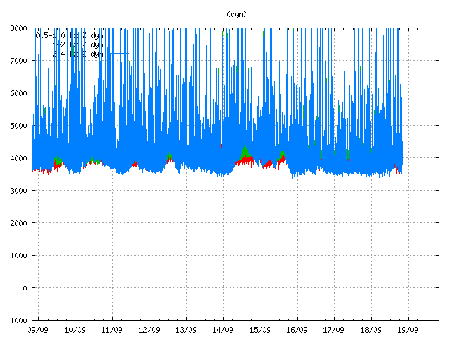
Tremor in Dyngjuháls SIL station. Copyright of this image belongs to Icelandic Met Office.
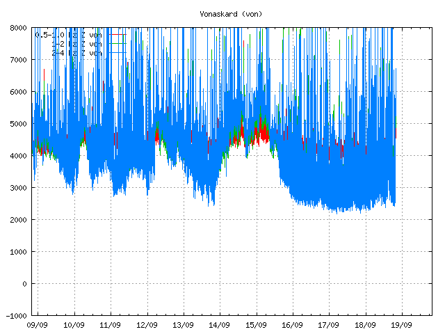
Tremor on Vonaskarð SIL station. Copyright of this image belongs to Icelandic Met Office.
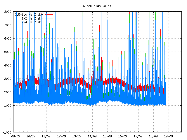
Harmonic tremor as it appears on Skrokkalda SIL station. Copyright of this image belongs to Icelandic Met Office.
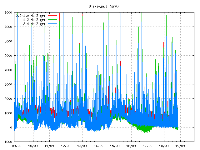
Harmonic tremor on Grímsfjall SIL station. Copyright of this image belongs to Icelandic Met Office.
Current status on the cauldrons
According to the news that I have heard some of the cauldrons that are in Dyngjujökull (south of Holuhraun) are still getting deeper. This suggest that there is still a lot of warm under the glacier that is melting the glacier. No glacier flood has happened due this. I don’t know if any new cauldrons have formed in recent days. Most of the cauldrons are located above the dyke, few are located above Bárðarbunga volcan in its slopes.
Tungafellsjökull volcano
I am seeing in the GPS data that Tungafellsjökull volcano might be getting more magma inflow. Since it appears to be inflating. This has not been confirmed so far. Currently there is nothing to suggest that Tungafellsjökull volcano is going to erupt at this point in time. It might simply be responding to the all the noise that Bárðarbunga is making at the moment, along with stress changes in the crust. If it erupts, it would be first documented eruption in the past 8000 years at least (maybe longer).
Next update is going to be tomorrow or sooner if anything major happens. It is possible to watch my webicorders here. They are updated every 5 min.
Article updated at 21:05 UTC.
Article updated at 21:14 UTC.
Thanks for continuing updates jon. Im getting somewhat knowledgeable now! 🙂
Thank you so much Jon for all your efforts, I don’t know what we do without you.
Well that update doesn’t look good Jon, to me it sounds like the whole place is unstable and that sooner or later something is going to give. One question though, how much more can the caldera take with all the 4-5+mag earthquakes that have been going on now for weeks.
Can you tell me how long is a piece of string? 😉
Might ask, Jon, what your seeing in those charts that leads to your conclusion of increased pressure? Thanks.
Thick spikes. Among movement that is above background levels (wind, ocean and such things). Earthquakes create a thin spikes on the harmonic tremor plots.
+100
Been waiting years to have this explained. Thank you
So we have another couple of Icelandic names to get our brains around.
May I add my thanks for all your hard work over the years with this website.
Can you give us more detail about the Vonarskarð dyke? I do not recall reading anything about this before.
This is a small feature that appeared in week 36. It is not as large as Dyngjuháls dyke that remains inactive at present time (if it existed in the first place). It has not been confirmed by Icelandic Met Office. It is also a not large feature from the looks of the earthquake data.
Reviewed earthquake data, week 36.
http://hraun.vedur.is/ja/viku/2014/vika_36/index.html#mark
Now, if it does not exist than that means that Tungafellsjökull volcano or Bárðarbunga volcano is inflating at extremely fast rate. It is bit difficult to read the GPS data at the moment since they are all over the place. Creating a lot of false signals in the worst cases.
Now is a good time to restate that all of this behavior is being seen in relation to a giant volcano that last had a large eruption in 1477, and is within a day’s walk of notoriously fast-charging giant Grimsvotn.
Just so everyone’s head is in the right starting place…
OMG is iceland still allive? .. 3dBulge, plots and cams not reachable … plots are @ afternoon offline also …
Jon. Here are some pictures showing eruption now: http://brunnur.vedur.is/myndir/webcam/2014/09/18/webcam_mogt_kverkfjoll.html#
Cloud deck so low, that is why Mila 1 and 2 fogged in. Eruption still going good and lava field getting bigger.
Hopefully by tomorrow night, wind change will allow better viewing.
Thanks for yet an informative update – I really appriciate all your work – and that you find time to share it with us, a lot.
ThANKS <3
I must admit that I dont get all the english terms yet – but Im trying to catch up – Im danish and new to volcanology (And honestly not very good at physics) so there is a bit to catch up on. I hope you can forgive me, for questions that are "stupid" – Im seriously interested in keeping up with what is going on – and understanding the biology of volcanoes and the earth even more than I do already – And – must admit – Ive fallen inlove with iceland – having lots of friends from Iceland, here in Denmark, and also some friends living there and working there – I know a bit about this awesome spot on our beutyfull planet.
And learn so much more from following this blog as "my Bardarbunga" tosses and turns in her beutysleep – making us all alert and the Holuhraun turn into the most spectacular, fairly harmless, view of how beautifull and fierce lavaeruptions can be, even in fissureeruption.
I now know, that this event is unpresidentet and that nobydy has a clue to what will actually happen, as terms, conditions, messurements and actual events change rapidly – and as the factors involved are numereous.
But You experts understand and see a lot that is understandeble to you, and that does make you able to make qualified guesses and predictions – for now.
I think yours, Jon, is at the very top, when it comes to credibility and value :3
I have 1 question:
Is there a point of no return, where you without doubt can predict an eruption in BB – or her silent twin – and if so, how precisely could the the time of the actual event be predicteted? How much warning would we get?
Thanks again 🙂
Yes, I know first hand that many Danish people don’t understand English so good. I have found that out living in Syddanmark (Aabenraa, Padborg) for the past two years.
The point of no return was at around 45 meters mark (+- 10 meters). That might have changed in recent days. I am trying to figure that out now.
What your new estimated threshold?
How have you done the calculations?
I am trying to do calculations. The big problem at the moment is that the system is highly dynamic at the moment and that is making any calculation accurately.
The Holuhraun eruption can be seen on the Kverkfjöll camera between the clouds…
http://brunnur.vedur.is/myndir/webcam/2014/09/18/webcam_mogt_kverkfjoll.html
Hi everyone….I have just got in and read this evening’s comments.
Good to see that the poles, tides and moon theories have been put to bed. (Yawn)
I agree with an earlier comment that the ice is in a diamond shape and it drops more so when the EQ’s are shallower. I also agree with previous posts that the bottom part is melting with the heat rising from the magma as it enters the dike. Hence the cracks and cauldrons visible on the surface. The outside of the glacier must be glued to the walls of the volcano as the rock inside must be porous? And the shallower the magma breaking up from the mantle, the higher the EQ as it affects the ice cap more.
And if I’m talking nonsense, I have just got in from the pub! but I have read every comment and article since the 16th of Aug
So out with the truth David. Do you cheat on your wife?
Nice one Thor
Big drop on the GPS !
Earthquake on Jon’s webicorder too
Yeah, see it. Decent but not huge. ~ M4? by comparison to the 0300 one?
Drop looks for real and sizable.
I was trying to do an estimate a date for the calder collapse.
For this I would need to know how much the “middle” of the calder can sink.
I did some rough calculations assuming that the main mechanism is the angle of repose,
but I got a value over 400m, so I guess this is not the mechanism that will make the collapse
(since I heard a while ago something like 100m and Jon said 40m).
Do you have ay other ideas of what is driving the event? (hopefully something we can quantify
and will allow us to start guessing 🙂 )
Can you explain your calculations?
Askja collapsed around 300 meters I guess, in its caldera eruption. Why would you say 400 meters as a threshold?
That would make the caldera floor down from 1200m to 800m. Almost as low as the surrounding plateau.
As I said is this is a very crude approximation (I use this figure as reference https://farm4.staticflickr.com/3843/15237314311_e73375d510_o.png) .
The caldera as a depth around 580m (with 800m of ice over it), it is very wide lets say 7km diameter.
If you “dig” inside the caldera it will increase the inside slope to the sides, above an angle of 30 degrees (minimum…) it would start to be unstable, because the
vertical tension would be too high (definitely after 45 degrees it is unstable, vertical tension is bigger than the horizontal).
As it looks like it is not sinking in the middle, but closer to one side, I make the distance to the side 1/4 of the diameter.
From this we get that
30 degrees=atan(max_vertical/(7/4))
So…
max_verical=tan(30)*7/4-.58=0.430363 km
(I subtract the caldera depth of 580m here).
Anyway this calculation looks like a big overestimation… maybe it is not coincidence that this calculations takes us to the level of the plateau, but still does not explain the collapse!
I don’t think it will take long to get past the 45 meter mark at its current rate.
Still another drop maybe. Don’t see the quake yet. The previous quake has been catalogued at 4.5
Looking at the GPS and earthquakes, I found it interesting that every second 5+ earthquake was followed by a steep drop. That’s happened several times and today, that pattern continued. Just an interesting observation…..
The correlation is with depth of the quakes if previous comments here are to be believed. Shallow quakes have caused drops, deep quakes haven’t. If deep and shallow quakes are happening with more or less the same frequency, they very well could appear to alternate.
Last quake that caused the drop was at a depth of 7.5 km, so not a real shallow one. I would have thought the same, but …
certainly some interesting recent movements on the GPS stations FJOC and HAUC
http://strokkur.raunvis.hi.is/gps/cgps.html
If this keeps up a drop which causes failure is imminent. But I can”t help thinking that the magma level in Bardarbunga may be such the roof collapse only means it is fully resting on magma, not dropping into a void.
In that case collapse will be slow and non catastrophic. Sorry to spoil the fun again,
With .7 km of fractured glacier sitting atop the lid, it’s the worlds biggest slushie
ITs gonna go big bada boom!
There is earthquake activity appearing at the start of the dyke in Bárðarbunga volcano. I don’t think that is good news.
Do you mean to the south east of the caldera? I see some new quakes there. Does that imply pressure has built up again in the dike perhaps due to a blockage, and this time the eruption could well be under the glacier? Or something worse?
You can see it in Week 33. This is either a change the current dyke (widening of it) or a start of a new dyke in the same area. This at least suggest that the pressure inside Bárðarbunga magma chamber is now so high that magma can’t properly flow out trough current dyke.
Week 33 reviewed earthquake data.
http://hraun.vedur.is/ja/viku/2014/vika_33/bab.gif
THANKS beyond easy words for your labors and your perceptive commentary. Greatly appreciated.
[b]I’m curious if taking up a collection for more webcams would be helpful???[/b]
I’ve been abidingly convinced in my . . . intuition . . . “hunch” . . . “impression” parts of me that this will be getting bigger and more dramatic. I still feel that way. Don’t know why. I pray scientists & citizens are safe.
I hope the electricity generating stations are not obliterated in some flood or pyroclastic flow.
Does anyone know of any good pics of the juncture of the lava flow and the river?
It sounded like the lava had more or less stopped it’s intrusion into the river bed. Is that still true? What’s likely in the near future on such scores?
Thanks again for all you do for us laymen. Making things clear and accurate without arrogance is a real gift and an art. Congrats.
This is my current favorite of the lava meeting the river, if that’s what you had in mind. https://twitter.com/uni_iceland/status/511526561913532416/photo/1 Credit: Uni. of Iceland/IES
THANKS. Much appreciated. Beautiful shot.
I’d also like to see an air-shot showing how much of the riverbed has been intruded into.
With respect to the Tungafell volcano, gps readings, and earthquakes, it could be possible that the more westerly NNE-SSW rift is becoming slightly active in addition to the hypothesized dyke/rift zone connecting Tonga to Barda area. On maps this rift appears to run directly underneath this volcano(Tunga) . It wouldn’t surprise me to see the full series on NNE-SSW rifts in the Vatna area experience some movement
I too have been monitoring Tungafellsjökull volcano and am coming to a simimlar conclusion, although I feel like it might be a ‘toothpaste tube’ scenario where crystal mush is being compressed by the activity in Bárðarbunga. Sort of like a balloon being squeezed. It would be very interesting indeed (and not good) if the activity at Bárðarbunga is activating or disturbing nearby systems… are you of the same mind as some volcanologists who believe the volcanoes of Iceland are all part of the same ultimate volcanic system, via the mantle plume? It certainly is starting to look that way. I would also be very concerned if rifting episodes and more dike intrusions were to occur SSW of Bárðarbunga, as this is the Laki fissure system….
Laki came from Grímsfjall volcano. Bárðarbunga has created a fissure eruptions like Tröllagígar.
Ah yes, I was being unclear… I meant to say SSW of Bárðarbunga is the Laki system (I do know they are separate). I believe it is possible that the amount of magma being injected to Bárðarbunga could weaken or disrupt other fissure systems, such as Grímsfjall/Laki. Do you suppose this could occur? It does seem to be shaking up Tungafellsjökull, Askja/Herðubreið. The quake activity in that region does look suspiciously like dike intrusion.
In the current episode, I am still shamelessly promoting the following hypothesis ( the current activity is mainly due to the MAR becoming more active in this area recently )
We know that the MAR ,Mid Atlantic Ridge runs through this area . It is a spreading centre. It appears to me from the gps and seismic and volcanic activity that the spreading(rifting) is going through an accelerated phase right now at Vatna area. Most of the spreading(rifting) will be along the NNE-SSW rift zones. This rifting/spreading could weaken magma reservoir walls allowing magma escape along the rifting, and possibly allow mixing from different pools of melt . In addition it could eventually allow very deep magma access to the shallower areas (including older magma). In addition, a rifting event does not have totally follow the NNE-SSW zones, it could do a right angle turn (strike-slip movement of sorts) and connect to the rift zone the east or west of it (I’m thinking Barda-Tunga here). Go to Google maps and zoom in on the MAR, anywhere between Iceland and the Azores, for example. In the month long sequence of earthquakes I believe I could argue for (drugs helps) 3-4 NNE-SSW rifts/faults running up to and beyond Askja in the north and sightly past Barda in the south , plus perhaps 2 or 3 strike-slip type rifts/faults , one from Barda to Tunga area .
– written by a frustrated Geophysicist trapped in the oil-patch 😉
GPS is all over the place. That unit at the caldera is bouncing like crazy. Bet it would be an interesting sensation sitting next to it in a lounge chair.
Not saying this is what is happening, since I’m not there, but GPS signals can bounce around a lot even while the unit is motionless. There is inherent imprecision in all GPS signals, and they are subject to atmospheric effects, reflection from the ground, clock precision errors, dilution of precision caused by the visibility of satellites and the angles between them, and the inaccuracy of the satellites’ own orbital data. This is exactly why GPS signals are averaged over time, and the more time, the better. Instantaneous changes in readings are more noise than signal.
The behavior has significantly changed over the past 10 hours or so. Something is going on.
This is becoming more and more a gas event. Magma is just doing it’s thing, while releaseing more and more gas over Iceland. As each day advances, more and more of this stuff is being released.
It may also excel as a flooding event. Hopefully this comment will be proved incorrect.
Jon, I have merged a bunch of dyn charts as a reference, so it goes all the way back to August.
I update this image every so often so it shows more current data.
http://zolaweb.com/images/long_term_dyn_graph.gif
Thanks for this. It is interesting to see the change.
Is there a link to a 3D visual of the deformations raised and sunk that would be ‘viewed’ from the side?
I haven’t seen an image that depicts all those changes very well.
It’s to bad we don’t have an update to these measurements of the caldera.
Sept 5
http://earthice.hi.is/new_mapping_surface_bardarbunga_caldera_indicates_14_m_subsidence_inside_caldera
Sept 8
http://earthice.hi.is/bardarbunga_subsidence_new_data
Jon, you mentioned above your worry of the quake activity starting to migrate to the SE of the caldera where this started to begin with. By these maps from earlier in the month. The southern end is tending lower than other areas of the rim. Sure would be nice for some new data here. These maps sure show how the whole volcano is sinking.
Interesting topology map of the Bardarbunga area
http://www.gopfrettir.net/g_vinir/ferdir/MFFmyndir/Leid13.jpg
Eqs on the range 1.1kms-2kms deep. I think like jon, no good news.
Gps is crazy at he moment, maybe the activity now is more gas and less magma .
Sorry, my english… buuuuuu, bad xd.
Good photos and info
http://en.vedur.is/earthquakes-and-volcanism/articles/nr/2947
The clear, mostly uncluttered, discussions here have opened a whole new world to me. I have followed all (sensible) references, am learning incredibly interesting things, and feel comfortable enough to ask stupid questions. However, the ones I have usually come up in the discussions before I can ask. Thank you all, especially Jon, who makes it all possible.
hen
To early to tell what this means, but quite a drop.
http://hraun.vedur.is/ja/Bardarb/BARC/
So far, appears to just be noise. Please ignore the instantaneous GPS changes.
The caldera GPS indicates some sort of disturbance. I would not volunteer to head there with my Garmin.
Even the 30 and 180 minute smoothed plots show worrisome instability. Remember this is a gigantic caldera so if the data is reliable, we can assume that something is happening in the caldera. The BB crater rim is compose of rhyolites so it is very possible that more evolved and explosive magma has moved into the area. I don’t know but if I lived nearby I would be on high alert.
Just like Mt. Etna, Iceland is the very definition of a volcanic zone and a very complex one at that. Usually it is run of the mill basalt, but then Laki was only that type of lava, but what an extraordinary event it was. Iceland is like Texas – everything is bigger.
The earthquakes appear to have stopped as well. Something is going on; let’s hope it is just ice on the GPS antenna and a declining trend in earthquakes.
Notice how the standard deviation around the GPS station is quite a big larger than ever before. I also noticed that the big earthquakes seemed to be getting shallower, whatever that implies (although to be fair the N is quite small.)
Has anybody else noticed that the MILA cameras don’t seem to be working? All I get is a static picture.
Apparently a plume sits directly under BB and Grimsvotna. Has this ever been verified ?
No mantle plume is verified. Period. They are a theory that is currently untestable.
Sound thinking, but you can’t actually see what’s going on down there, so we look at data and make educated guesses as to what is going on. The mantle plume theory is widely accepted. But you can’t really call that “verified’
It has pretty much been verified. You can use propagation time from seismic activity as a sort of “sonar” and propagation of waves through solid material is different than through liquid. They have the plume pretty well mapped out.
So it looks like we see a significant reduction in earthquakes yet a massive increase in GPS instability. I’m not sure what to make of it but surface instability like this in a system this large bears watching.
We could surmise that glacial ice which is quite plastic compared to solid rock, and magma which is liquid, or at least plastic would show little EQ activity since they would deform rather than shatter. At least that is my simple model.
That would leave us with the caldera heaving, and thus the GPS moving, and/or the idea that more gaseous and volatile magma has invaded the lower caldera and is heaving the ice. The cauldron may be coming to a boil, but the nature of the ice and magma lead to ductile deformation without the EQ’s. Nevertheless, the kettle may be coming to a dangerous boil. Damn, if only I could remember the phase diagram of ice/water/steam!?
GPS instability might be ice collecting on the GPS receiver again. Remember, cold + thick fog = ice buildup. And its likely to be cold and foggy there right now, and ice was responsible for other GPS readings gone haywire.
Might be something else, might not be. *shrug* don’t read too much into it.
Yes, I suppose that is possible. We’ll have to wait and see. I don’t like it, though, when I see fundamental changes in behavior.
SO, I have been a lurker through RSS for quite some time (like 2+ years). I have been watching the Mila cams and setup some automatic screen recordings. About an hour ago, ~2315 USA Central Time, the fog cleared up a bit and I saw an orange glow up high on the window. I checked my recording and it shows up there and the flashing lights of R2 are down low, where they should be. Possible the glow of an eruption on the volcano or the glacier? I’ll try to post screen shots and maybe can get some video uploaded to YouTube. Thanks for this site, Jon – we have been using your links to buy on Amazon and will donate soon!
Well, As I entered the above post, the glow is starting to show on Mila 1 again. I guess it could be the reflection in the clouds with fog blocking the actual eruption site, but seems to be in a different area than before.
I hope no one minds weather updates for Iceland as I see it from the charts. Been a calm night with hardly an isobar on Iceland, therefore masking all the views from the webcams. A cold front from the west linked to a weak low to the north of Iceland will move over by midnight tonight folowed by some quite strong ridging. I am hoping this will mean tomorrow will be good visibility with some sun as the little wind there is will be from NW. Air should be drier and fresher and clear slots. I do not know Iceland itimately – wish I did, but it makes sense die to amount of land, colde seas to the north and ice sheet to south of the cams.
Typical Iceland – Weather changes rapidly for Sunday with a depression 980mb to the west near Greenland, bringing in winds and rain to all parts. Likely to be gales and strong gales further west. Calms right down for Monday with the prevailing light southwesterly. So Saturday and Monday best prospects to view. Calm again Tuesday.
Great update Jon. I hope the donations are flowing in. Don’t forget folks it is important to support Jon Frimann which in turn supports our interest.
thx for the update =) wow harmonic tremor pulses is rising wow this is seriouse and im a bit affraid off the volcano caldear to collapse but i dont know contiune doing ur great work jon ur awesome whit these updates =) il u’pdate my school later today
I really do wish people wouldn’t get hung up on the latest GPS reading. They are irrelevant, completely and utterly.
The GPS units have an accuracy of +/- 3 Metres at best, which is why an everage is used.
In fact, if you look at the plot for last night – there were indeed 3 Metre swings on the plot. Atmospheric conditions have a HUGE effect on the very weak signals used to take measurements. Ice, fog, maybe even a solar storm.
For all the spikes last night, the average lines only show the usual continual drop. Nothing dramatic.
http://en.wikipedia.org/wiki/Error_analysis_for_the_Global_Positioning_System
That will just confuse most people. It’s part of my line of work though…
I understand there is noise and the signal should be averaged but surely they use some sort of DGPS with higher accuracy than +-3m. I would say +-10cm (vertically) is a more realistic figure.
They’ve put an instrument out there that they will likely never see again. You really think they’re going to put a top of the range, super duper expensive unit on a collapsing volcano?!
Your theory doesn’t stack just based on last nights readings – as said before, they clearly show the +/- 3 Metre errors.
I’m no expert at all, but I think they are pretty serious about their measurements. Found a photo which I believe shows the instrument. From facebook
New EQ, close to M5
I’m with you, Andy. I’ve worked with expensive surveying GPS, and even those take time to get an accurate averaged position. 3 m accuracy is horizontal… vertical can be worse. People just need to ignore the “bouncing” and focus on the trendline.
Even a mm of standing water/dew or ice/ripe on the gps receiver will/can make it go berserk….
Thor, thanks. Just look at that nice flat antenna waiting for water, ice, snow to settle on it 😉
If the readings in the night that showed the big jumps were real, the quakes that a mountaion jumping up and down 3 Metres will have made, would have shaken me out of bed a 1,000 miles away!
Of course the spikes are not real, but it could be slight rumbling or just ice that is causing it. The wind seems to be quite calm.
What does it mean if the caldera starts to move up again and pressure builds from below?. Maybe an impossible senarion. But anyway?
Momentary deviation on the graph (1800-0600) all over the place – significant or indicates trouble ahead? Last 3 quakes seem to be at least mag 4 too.
If magma is coming into the “system” and the caldera continues to drop surely this will increase the pressure making an explosive eruption more likely?
Sure, the GPS readings have to be taken with a pinch of salt. But to say they are completely and utterly irrelevant is also untrue. They wouldn’t have bothered putting it there if it was so irrelevant.
It’s highly relevant. The blue line shows that it is dropping.
I never said the GPS readings were irrelevant, I said the INSTANTANEOUS readings are irrelevant. You can only use the averaging provided on the chart, not any individual reading in isolation.
For all the times people have said “massive drop” or “massive uplift”, hours later it’s all averaged out to the continual downward trend we are seeing, excepting the drops seen after the very large quakes, which are more likely the ice settling than the actual caldera dropping.
I actually said “Latest” not instantaneous, but I mean the same thing.
The point is, no one has ever witnessed a mountain jumping up and down, so it’s safe to assume it’s not happening!
Except it’s not really dropping any more.
In my imagination i think that this is a huge stirling engine, working in cycles. Hot magma under the ice , getting hotter and hotter, a layer of melt hot water above, in huge pressure , several hundred atmospheres. I dont know exactly, in which temperature that water starts to boil in that pressure, must be at least 500 -700 degrees C. When heat is able to vaporize some amount of water, (or magma is getting in contact with water), this will lift up the whole icecap (=piston) or parts of it, icecap momentarily rises a little but then again melting cold water will condensate that steam back to water and and lava piston comes down again. Anyway in the long run this will melt more and more of that ice and icecap gets thinner all the time.
Feel free to tell your opinions about this !
If an online Boiling Point Caulator (and i hopefully used it properly) is correct than the boiling point of water at 100 atmospheres is 286 celcius.