
This article is short because the situation is always changing. This is about the volcano Fagradalsfjall but I have also added Krýsuvík because that volcano is being updated at Global Volcanism Program website. I am not sure currently what volcano is considered active in this make injection. This article is written at 20:39 UTC.
Today (12-March-2021) at 07:43 UTC an earthquake with magnitude of Mw5,0 at 3,7 km depth took place close to Nátthagi valley just south of Fagradalsfjall mountain. Over the last 48 hours 72 earthquakes with magnitude above Mw3,0 have taken place. This earthquake activity is happening at the south end of the magma dyke that has now stopped moving south but continues to expand based on the earthquake activity that is now happening. This is also the location where an eruption might happen without any warning or strong earthquake activity. Eruption out on the ocean is no longer considered a possibility because the magma dyke stopped moving south.
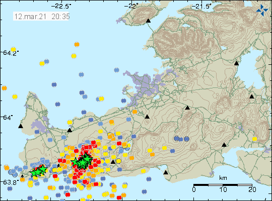
GPS data shows that inflation remains heavy and has moved some GPS stations up to 120mm over a time period of two weeks. There are no signs of this inflation stopping or slowing down.
Web cameras
Beint vefstreymi af skjálftasvæðinu – Borgarfjall (Rúv.is) If an eruption happens. This camera maybe has the best view
Beint vefstreymi af skjálftasvæðinu – Efstaleiti
Live from Iceland
Road camera 1
Road camera 2 (night vision/infrared)
Next article is going to be on Monday 15-March-2021 if an eruption doesn’t happen or something else major doesn’t happen. I am hoping to get weekend break this weekend. If that is going to be successful is currently unclear.
Donations
People remember to donate to support my work if you can. Thanks to everyone that have donated already. It helps me a lot. Thanks for the support.
Hello Jón and everyone , can you or someone help me reading this gps graphs?
http://brunnur.vedur.is/gps/reykjanes_rt.html
In some there are huge up and downs.
The red line is the difference between two gps stations?
Im sorry, im new at this.
Thank you
This are real time GPS graphs and subject to errors and can only be used in limited way. It is better to use GPS data that is updated with error corrections once a day.
Looking at the Nátthagi valley from Borgarfjall, am I seeing things or is there less water in the lake than yesterday?!
Hi, I am not able to load the image. With the colder weather today it could be that the lake is frozen, and perhaps creating an optical illusion. I am only surmising here, you may well be right, if so, Jón would be the best person to comment.
The Borgarfjall camera works for me. They have changed the viewpoint since yesterday on the Bogarfjall camera. It is now pointing more north than yesterday when it was more towards the valley and the hill directly in front of it.
And I know who that was. 😀
https://ibb.co/YDcz7bB
Haha!
Also, activity has picked up again with a bang. Mw 5.4 recently, and another 5.0 and so on.
Hello Jón and everyone. Three earthquakes very near Blue Lagoon. One of them 4.1
Probably tectonic
Picture of what the magnitude Mw5,4 earthquake did in damage in Grindavík town.
https://www.ruv.is/frett/2021/03/14/othaegilegt-og-madur-venst-thessu-seint
RUV captured the 5.4 earthquake on their Borgarfjall webcam – you can view it here
https://www.ruv.is/frett/2021/03/14/skjalftinn-nadist-a-vefmyndavel-a-borgarfjalli
I am not sure but I think I might be seeing some deformation on the ground at the Borgarfjall webcamera. This might just be the trick of the light but magma would deform the ground in obvious way before an eruption.
Comparing a screencap from earlier today, it rather looks as if the upper edge of the lake was straightened – as you say, could be a trick of the light.
Here are pictures of rocks falling into the coastline after the Mw5,4 earthquake today (14-March-2021).
https://www.mbl.is/frettir/innlent/2021/03/14/hefur_hrunid_ur_festarfjalli/
New article later this evening.
Hello Jón and everyone . It apears that the earthquakes shifted to the north of the dike intrusion,
https://en.vedur.is/earthquakes-and-volcanism/earthquakes/reykjanespeninsula/#view=map
The magma maybe encounter another path? Its possible that the eruption happen further north?
Waiting for your article to learn more about this seismic crisis.