
This is a short article about the activity in Fagradalsfjall volcano. This article is written on 11-March-2021 at 17:34 UTC.
This morning at 08:53 UTC an earthquake with magnitude of Mw4,5 took place west of Grindavík town. Second earthquake with magnitude of Mw3,2 took place at 09:03 UTC. This earthquakes are not connected to any magma movement in this location. The reason for this earthquake activity is because of the inflation from the Fagradalsfjall volcano dyke. According to new measurements the dyke in Fagradalsfjall volcano is moving around 500 meters every 24 hours. Currently the dyke has moved more south but it was moving south-west yesterday and the days before that. Today (11-March-2021) the dyke has only 2 to 3 km left until it goes under the ocean and a road called Suðurstrandarvegur (road 427). If the magma reaches the ocean and an eruption starts, it is going to be an explosive eruption while the ocean can access the main craters that are erupting. Depending on locations this can go on for weeks and is going to form new islands that might only exist for short time period until the ocean erodes them away.
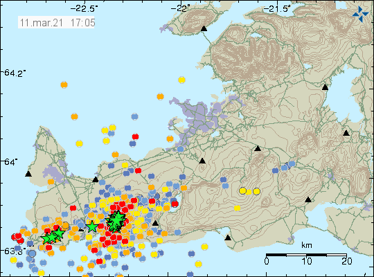
If an eruption happens before the magma dyke reaches the ocean the magma only has 2 to 3 km left until it reaches the ocean and it is now expected if that happens that the lava is going to reach the ocean in 6 to 10 hours and go over Suðurstandarvegur (road 427). Since 24-February-2021 over 34.000 earthquakes have been recorded by Icelandic Met Office in this volcano activity.
Web cameras
Beint vefstreymi af skjálftasvæðinu – Borgarfjall (Rúv.is) New!
Beint vefstreymi af skjálftasvæðinu – Efstaleiti (Rúv.is)
Road camera 1
Road camera 2 (night vision/infrared)
Live from Iceland
Hi Jon. When you say that the dyke is “moving” 500 meters a day what exactly do you mean? Is the dyke expanding in a linear fashion? or ???
The dyke is pushing it self in south direction according to measurements of Icelandic Met Office by 500 meters a day. In a about four to seven days it is going to be out in the ocean at current speed. This is also creating swarm of earthquakes at the south end of the dyke.
Expanding in the least path of resistance. Is maybe this like a sill, between layers, rather than a dyke at this point?
This is still a dyke. It has shallowest point at 1 km depth according to measurements and there is now fear that it might erupt in close to Nátthagi without any warning, between or close to Borgarfjall where the new web camera is located (link in article). The dyke is going to continue until it meets a resistance it can’t break trough and then it is going to erupt. There is nothing suggesting that inflow of magma has slowed down and it might even increase for a while once eruption has started.
Like opening a bottle of champagne!
I Hello from Portugal. I have one question. On the ruv.is cam at Borgarfjall, i see a glow, i doont know if it is a city. What is it?
This would be the lights from Grindavík town. Its the only town in this part of Reykjanes peninsula. You can see this on Google Maps
https://goo.gl/maps/phqN4maBDLHi6AeT8
What are the lighter parts that you can currently (22:40hrs) see in the left top corner of the Borgarfjall-cam? The eruption that has surfaced or is it the city light of Grindavïk that reflects in the clouds?
This is just reflected light from Grindavík town or some other human made light source. I am not sure what direction the camera is in relation to Grindavík town but there is not a lot of population in this part of Reykjanes peninsula. Currently the eruption has not yet started according to latest news.
The Borgarfjall camera might be seeing light from Reykjavík rather than Grindavík depending on where it is pointed.
Hi Jon. Really appreciate the updates. My understanding is that the camera (https://www.ruv.is/frett/2021/03/11/beint-vefstreymi-af-skjalftasvaedinu-borgarfjall) is here: https://twitter.com/krjonsdottir/status/1370100855161110534 – Nátthagi valley looking north.
Well it’s strictly north east so most likely Reykjavik as you say.
I was thinking that when I did see the static image that Rúv has on the web stream. I don’t know directions on the ground in this area so I was little confused. But there are not that many light sources in this area. Just Grindavík town and Reykjavík to the north-east as you say.
Thank you all for clarifying this.
Ok, thank you Jón.
On the webpage of the camera says that webcam is located on Borgarfjall and looks west over Nátthaga and on Langahrygg and Stóra-Hrút.
Hi there!
We see a brownish (dry) lake in the webcam image.
It’s this: https://commons.wikimedia.org/wiki/File:Iceland_road_427_Hraunsvik_Skalabot_Borgarfjall_Langihryggur_IMG_0168.JPG
here https://ja.is/kort/?x=338614&y=378046&nz=14.65&type=aerialnl
Very near to the ocean yet!
Of course, with this sort of situation one expects all sorts of twists and turns, both literally and figuratively. I think it will be very interesting to get Jón’s impressions on the results of today’s all-agency meeting. Right now, it doesn’t seem as though the magma corridor is heading for the coast.