
There has not been major change in Holuhraun eruption since last week. The eruption continues at low phase at the moment far as I know. Bad weather has prevented scientists monitoring the eruption in the past few days. There continues to be considerable activity in Bárðarbunga volcano, the volcano continues to deflate.
Earthquake activity in Bárðarbunga volcano for the past 48 hours. Green star is a magnitude 4,1 earthquake that took place at 14:18 UTC on 18-February-2015. Copyright of this image belongs to Icelandic Met Office.
New vents might open up along the dyke once current vent closes up in Holuhraun. There seems to be several weak points forming along the dyke, based on current earthquake activity (cluster of earthquake activity). There is also a risk this might happen before the eruption in Holuhraun ends. If the pressure inside the dyke is enough to start an eruption in new location before that.
The long term view of Bárðarbunga volcano
When the eruption in Holuhraun ends it is not going to mean the end of activity in Bárðarbunga volcano. Current activity is just a start of activity that is going to last for several years. According to Ármann Höskuldsson volcanologist in a interview at Rúv News yesterday. While it is not known for how long the rift episode that has now started in Bárðarbunga volcano is going to last. It is clear that this is at minimum of 5 years, common time for rift zone activity is up to ten years. There is a chance it is going to last longer than that. When it comes to Bárðarbunga volcano how long such activity is not known. There are also going to be breaks, with no activity at all between eruptions. Activity in Bárðarbunga volcano won’t be declared over until it is once again stable. Eruption activity in Bárðarbunga volcano might not end until the year 2026 at the longest.
Donations: The PayPal buttons are back up. Please remember to support my work. It is also possible to support my work buy buying stuff you need from Amazon. Thanks for the support.
Jon, Thank you for the current update. Have been thinking for awhile along the same lines that you mentioned as possible outcomes for the current eruption. However, I had not thought about an eruption in the dyke as channels block to Holuhraun. Thanks for the new information and ideas. 🙂
I can’t remember his name, bur last year a scientist said that the current eruption would last until March 2015. To me, it is looking like he may be right.
Yes, he could be either right or wrong. But why?
It is my view that he is wrong. Only for the fact that the eruption is only in part due to subduction of the volcano. What he does not add to his calculations is the fact this is also a rift zone eruption. It is not just the Bárðarbunga volcano erupting. That system got unstable due to the rift zone starting to rift like a zippier that is broken.
The subsidence of Bárðarbunga volcano might stop, but the eruption in Holuhraun might continue for a good while longer. Maybe up to a year longer. What is also important is the fact that the eruption might keep going at slow rate for many months.
The volcanologist you are thinking about is named Haraldur Sigurðsson. It is my view that he is wrong. Here is his blog about this, it is in Icelandic.
http://vulkan.blog.is/blog/vulkan/entry/1585479/
Rifting may have stretched the caldera, itself. Speculation on my part but, if correct, Bardarbunga will end up with an oval caldera rather than a round one like many of her sisters.
IngeB says:
And how would we know that the magma in the dyke has finished to solidify? (Such an important batch – minimum 5 m x 15 km x 45 km.) Eg. the magma that erupted as lava during the Krafla eruptions has still not totally cooled down, 30 years later.
The rate of solidifying of underground magma depends mostly on the amount and shape of the magma. Icelandic rift dikes are very narrow and very deep, like a vertically held sheet. Even though the magma comes 2,000 degrees hotter than the surrounding rock, it will cool and solidify surprisingly quickly.
The channel of flowing magma from Bardarbunga to Holuhraun is very different. The magma will carve and maintain a roundish tube which will stay indefinitely open as long as the 2100 degree magma keeps on coming.
There is a bad signal on SIL stations around Vatnajökull. I am monitoring it.
What do you mean by “bad”?
Interesting Jon, I’m watching Hus in particular
http://snag.gy/SxPKU.jpg
I think its mostly noise, but its not showing through the same on other stats.
Yes, Jon – what does the bad signal eventually mean? And: why are you saying the eruption is latest ending in 2026? Because the comet? That would be realy black humor 🙂
No, this eruption is going to end. We might get a short break (days to months). Then a new eruption is going to start in Bárðarbunga volcano. There is also a chance no break is going to happen and new eruption is going to start before the eruption in Holuhraun ends.
This might continue until the year 2026 with breaks. Since this is an rifting event. Not just a volcano erupting without rifting taking place.
Look at the jump ?
http://hraun.vedur.is/ja/vatnajokulsvoktun/djk1_trem.gif
Any other ideas than the earthtide for this 24 hours rhythm of the GPS?
http://hraun.vedur.is/ja/Bardarb/BARC/
Yes. 🙂
Night -> cold -> antenna iceing.
If it were tides, you would see the same behaviour in a (little over) 12h rhythm.
Hmm good idea but now (10 am Iceland) is it colder than during the night…and it was below 0 °C nearly the hole day…we should check the signal strange from the gps sender…
http://en.vedur.is/weather/observations/areas/centralhighlands/#group=61&station=5932
And for the earth-tide, it could be only one vertical main peak during a 24 hours cycle…
http://www.colorado.edu/ASEN/asen6090/SolidTides.ppt (page 3)
http://mynd1.mogt.is/mobile2/images/left/m150219113002540.jpg
Left top corner -12° … BB is not so far away and should be similar so “cold” is no reason.
Any other ideas?
Offline pic’s:
https://cementboy.files.wordpress.com/2015/02/weather1.jpg
https://cementboy.files.wordpress.com/2015/02/weather-gps1.jpg
Earthquakes and eruptions are not influenced by earth tides, see Erik Klemetti: http://www.wired.com/2012/05/on-earthquakes-eruptions-and-the-moon-eruptions-revisited/
“The Moon plays a very small role in increasing seismicity and volcanic activity on Earth – potentially increasing activity ~1% during full/new moons.”
Cementboy is correct. That 1% change won’t cause earthquakes, but it will be measurable by sensitive instruments placed on top of ice sheets.
Especially in the winter, when the full or new moon is further to the north than in the summer, earthtides are apparently measurable just after midnight. Temperature is usually lowest just before sunrise, well after midnight.
The full moon is further to the north, but the new moon is further to the south, weakening the 1% effect.
Rethinking this earth-tide thing.
The vibrations just after each midnight are related to solar solid tides. Since Iceland is so far north, these should be maximal after midnight in the winter months and just after noon in the summer months. This is because of seasonal re-orientation of the tilt of the Earth’s axis of rotation.
Since the Moon rises later each successive night, lunar tides shift forward almost an hour each night. I don’t see that in the record.
Thursday
19.02.2015 02:07:49 64.665 -17.411 2.0 km 3.3 99.0 6.2 km ENE of Bárðarbunga
Thursday
19.02.2015 01:26:10 64.667 -17.455 0.6 km 4.3 99.0 4.6 km NE of Bárðarbunga
Possibly some effect due to solar wind interference in the ionosphere impacting on the gps signals it uses from orbiting satelites? There have been spectacular auroral displays over the last few days.
Interesting to see if this continues or not
Comment refers to the apparent 24hr gps perturbation commented by cementboy et al above
There are indeed interferences on the nightside of the earth as can be seen here http://adsabs.harvard.edu/abs/2014EGUGA..16.3435V
and here http://www.ips.gov.au/Satellite/6/3
And, also right, we have had a geomagnetic active phase last 1/2 week.
You have all convinced me, not claiming the low temps for the GPS-phenomenon. Did a little google and changed my opinion.
http://lasp.colorado.edu/home/wp-content/uploads/2012/07/Tilvetz.pdf
Fig. 3-5 show haviest effect around local midnight.
Never seen this before ?
http://hraun.vedur.is/ja/vatnajokulsvoktun/djk1_trem.gif
http://hraun.vedur.is/ja/drumplot/djk.png
http://hraun.vedur.is/ja/drumplot/von.png
This was maybe a minor eruption. There is also a chance a hydrothermal system in Bárðarbunga volcano did go crazy after the earthquake swarm last night.
Interesting concept, the pulsating could be a geyser type activity of subglacial water seeping down and blowing back.
The question being how much water and the silica content of the magma in the upper chamber. If, and I am sceptical, the magma is from the same deep chamber as holuhraun, then there is a possibility the silica is higher now, if you follow Bowens reaction series (crystalline fractionalisation) and hinging on it being the same source reservoir.
I think they key here is when we see inflation.
Yeah, what’s going on? Pulsating movement?
New video of the eruption in Holuhraun. This video is from 17-February-2015. It appears that the eruption might end in next few days in current crater. New crater might start opening up soon if the pressure continues to build up in the dyke.
http://www.visir.is/sjadur-breytingarnar-a-gosinu-i-holuhrauni-haraldur-ansi-sannspar/article/2015150218772
She seems to have built a decent sized crater. How big is that now?
about the size of an aircraft carrier
It is about 100 meters wide and 800 meters long (far as I know).
Thank you. How high?
The height could be around 100 m now, but this is just guessing, as I read sometime ago that is was around 80 m then.
I stand corrected. It was more than 100 m yet at the beginning of october: http://www.visir.is/gigurinn-baugur-er-thegar-100-metra-har/article/2014141009106
Jon, I’m surprised about your 800 m crater length. So far I’ve heard 400-500 m. Which is already massive!
The 800 m is perhaps even to conservative, here the active vents within the crater are still about 400 m distance from the rim: http://en.vedur.is/earthquakes-and-volcanism/articles/nr/2947 (photo by Ármann Höskuldsson, 15 february 2015). And in the Icelandic text that goes with it http://en.vedur.is/media/jar/feltvinna-JHI_2015feb_11-12.pdf , Dr. Höskuldsson says that even between these vents there is again a distance of 350 m. So I’d think, Baugur has a length of more than 1.000 m. The width of the lava lake within the crater is 100 m acc. to the a.m. volcanologist.
New field report from Holuhraun: http://en.vedur.is/media/jar/Report-from-eruption-site_17-19-FEB.pdf
Video in this news report shows the eruption on the 17th of Feb. With some clips of how it was earlier the 12th dec and 31st of jan.
http://www.visir.is/sjadur-breytingarnar-a-gosinu-i-holuhrauni-haraldur-ansi-sannspar/article/2015150218772
ah …you got me to it… please delete 🙂
Interesting video.
Also,
http://www.mbl.is/english/nature_and_travel/2015/02/19/the_eruption_could_soon_be_over/
Subsidence seems to have completely stopped now, for at least 3 days:
http://en.vedur.is/earthquakes-and-volcanism/gps-measurements/bardarbunga/caldera
What does it mean? Nothing can be seen from Mila cameras at present, but the eruption did not stop yet as far as I know.
Inflation of Bárðarbunga volcano might have started again. As one would expect from a rifting event like the one that is taking place now.
I see a lot of GPS movements away from Bárðarbunga on this map, if they are correct, but they are too many to not show a tendency: http://en.vedur.is/earthquakes-and-volcanism/gps-measurements/bardarbunga/ (the map in the middle of the page) And that could mean inflation, fresh magma streaming in which would push the stations away from the volcano.
By a connection between inflation of the volcano and the rifting event, would you mean the production of decompression melt, Jón?
Your observations are good Inge, whilst I know Jon does not agree with me (which I respect as he is very good at this), I can only attribute the directions of gps movement to involvement of the hreppar block.
Previous papers prior to this event have attributed perpendicular rotation to the microplate, there was also much variation in estimates of its size. The most recent data I have seen points to it being around 90km across and sitting right at the top of the hotspot or theoretical plume and it can rotate in any direction (multiplanar) subject to movement of the continental plates. Since we cannot see down there this can only be based on best knowledge that fits.
This all being accentuated by the rifting caused by the dog leg of the mar as it passes through this region.
If magma intrudes I believe it will be taking advantage of passageways being opened by tectonic movement rather than forcing such movement by virtue of its pressure.
The video of the eruption at Holuhraun was amazing. The current eruption has really slowed! However, I am wondering about the current levels of SO2 in the lava that is now being erupted. I have always understood that if lava has high levels of SO2, it is coming from great depth. So, I am thinking that this event at Bardarbunga is not really ending until SO2 levels drop, and this will be a sign lava has slowed and will stop rising from depth. An example of this scenario would be the Laki eruption. I would appreciate any thoughts and comments about this theory, and how it might relate to the current situation.
I realize that this is a very simplistic view of a volcanic eruption. I am wondering if SO2 levels in an eruption can be used as a measure of length of time an eruption will take place, or possibly what stage an eruption is in.
The amount of SO2 output depends on the amount of magma erupting. With less eruption of fresh magma there is less output of SO2 in the air (thankfully).
Meanwhile, Askja is resting quietly
http://en.vedur.is/earthquakes-and-volcanism/earthquakes/myvatn/#view=map
https://www.google.com/maps/place/65%C2%B001%2744.4%22N+16%C2%B040%2730.0%22W/@65.029,-16.675,14z/data=!4m2!3m1!1s0x0:0x0!5m1!1e4?hl=en
Most of the (earthquake and GPS) action are concentrated on Bárðarbunga caldera and the length of the intrusion. http://en.vedur.is/earthquakes-and-volcanism/earthquakes/vatnajokull/ But there were still some quakes also around Askja caldera and Herðubreið resp. Herðubreiðartögl to the north of Askja (but within the same volcanic system). http://www.lmi.is/bardarbunga/
What do you think are the chances that the magma coming from Bardabunga will disrupt Askja?
Bardarbunga
IMHO it is not very probable that Askja should now come into play. The reason being that there is a barrier in between built up by the Holuhraun craters and their dykes. And magma just uses the easiest way to move – as we saw eg. at the beginning of this volcano-tectonic episode when the big dyke, the intrusion, changed direction so as to accommodate to the tectonic environment it found beforehand – and such abrupt turns by the way have been made by magma in the past. Prof. Á. Gudmundsson eg. found a very long dyke of the extinct Álftafjördur volcano in the south near Höfn which has the same bend and at exactly the same angle!
Important update of Almannavarnir on the GPS- and subsidence situation:
The rate of the subsidence in Bárðarbunga caldera had decreased substantially. But that is not the whole story. Ice is subsiding into the caldera with the effect that the GPS station does not show any changes. The estimated depression of the rock foundation of the caldera, in the light of the ice subsidence, is about 5 cm per day. The flow of magma from under Bárðarbunga is believed to be 25 – 30 m3 per second, which is about one tenth of the flow in September last year.
GPS measurements near Vatnajökull glacier show continuing slow deflation towards Bárðarbunga, indicating a flow of magma from under the volcano
Source: http://avd.is/en/wp-content/uploads/2014/09/Factsheet_Bardarbunga_20150220.pdf
25-30 cu m/sec is still substantial. If it is not erupting at Holuhraun, then it is pushing deeper into the underground dike system.
I wouldn’t think that magma is going deeper, because of its buoyancy, it would in the contrary go upwards or sideways. I think, the quakes we now see again in the dyke – it had gone more or less quiet as long as all the channels were open -, indicate that the pressure therein is rising and magma is looking for a way out, perhaps under the glacier. Could be that there has yet been a small a eruption there like Jón indicated.
Was not going to comment again ,but it has to be pointed out that from the badly translated stuff I have seen posted.There is a deep chamber where Holuhraun has erupted from and a shallow chamber under the caldera in which the magma ,long cold has now heated up,there is no direct connection between the two but the deep chamber is heating the upper chamber,so now there is a reactivated caldera in the mix.Is this interpretation correct?
“Was not going to comment again ,but…”
And yet you did. Le sigh.
Anyway, I think, it is good to have you back, JB. 🙂
I am not sure, what text you are referring to here.
But I saw another part of the lecture, which Dr. Höskuldsson held in Reykjavík some days ago (it seems, they are publishing it bit by bit), and there he mentioned an upper chamber. I think, he is talking about at least two chambers there, like you say, seemingly following the theory about the big magma reservoir, deep down (perhaps the same as Á. Gudmundsson describes as a “regional dyke”) and a shallow chamber just under the caldera.
(…) .Ármann (…) útskýrði að kvikan kæmi úr kvikuþró á miklu dýpi undir fjallinu en ekki kvikuhólfi sem sannarlega liggur undir sjálfri öskju eldfjallsins. Kvikan kemst ekki upp á yfirborðið í gegnum fjallið sjálft og leitaði því í þann farveg, sprungurnar, sem fóstrar eldstöðina norðan jökulsins í dag. http://www.visir.is/goslok-ekki-endilega-godar-frettir/article/2015702189947
My translation:
Ármann [Icelanders normally use first names, because family names don’t exist in Iceland] described that the magma came from great depth under the volcano and not from the magma chamber which probably is to be found under the caldera itself. The magma can’t go up to the surface under the volcano and because of this took this different way, the fissures which feed the crater to the north of the glacier today.
It seems the magma from depth did not have a path to the shallow depths of the caldera so created its own path to the current lava field,now it possibly does have a path at sorts and this has energised the shallow,more than likely evolved magma deposit under the caldera.This process possibly explains all the seismic activity and deformation in the caldera as all that energy infused into the cool shallow magma?Also would it explain the 10 year expectation of increased activity?
How would the seismic energy just relate to rising heat, if not (also) to a caldera subsidence? The Ferdinandina caldera event in the 1960s and the Dolomieu crater collapse (Piton de la Fournaise, 2007) both were also accompanied by 5+ quakes.
On the other hand, the 10 year expectation of heightened activity comes from the experience of the Krafla rifting event which took place from 1975-1984 and also from research on other past rifting events.
It’s not enough to explain the increase in pressure in the (most likely) af.m. big magma reservoir solely due to influx of new magma. Several mechanisms may apply including mixing processes of magma, as described in chamber and conduit models.
“The period of repose occuring between injection of new magma and any subsequent eruption suggest that the injection of a volume of new magma is not, in itself, sufficient to provoke an eruption immediately, and that some secundary effect(s) of the injection causes the critical overpressure”
Anticipating volcanic eruptions
(Joan Marti and Arnaud Folch):
https://books.google.nl/books?id=4LswmjBnlJMC&pg=PA105&lpg=PA105&dq=magma+chamber+overpressure&source=bl&ots=eUmLAuzCHo&sig=BLd5W9-YeEunZ6TTpSRNMaGmT9E&hl=nl&sa=X&ei=s0ToVOnYEouqPIHogeAI&ved=0CGwQ6AEwDQ#v=onepage&q=magma%20chamber%20overpressure&f=false
3.3 at only 0.5km in the area of a suspected cryptodome? That should raise a slight eyebrow…
@ingeB,That is probably correct,I am trying to make sense of some rather confusing interviews(very bad translation by someone who knows nothing about volcanoes?) over the last few months that have hinted between the lines at a shallow magma chamber.
The shallow flat chamber at 3km+under the caldera is suggested by a gap in earthquake activity under the caldera. Magma slush doesn’t have EQ’s. It can be seen in the 3D time sequence movies from IMO.
Extreme cold weather is going to be in Iceland tomorrow (Saturday 21-Feburary-2015). The frost is expected going down to -20C in part of north coast and down to -30C in Vatnajökull glacier area.
Sorry to be off task here, but I must make this comment. Oops! The Eastern part of the US is in shock over one of the most unbelievable winters on record. Last night at my daughter’s home in Cincinnati, Ohio (US) the temperature was -15 F or -26 C! I have never known of such a low temperature that far South. We are getting a taste of Iceland winters here! Help!
Strange, 8-10 years ago, when I arrived in Poland, strong winters with -20 to -30 C were normal. In the last years it was max -10, rather around 0 C, even winters without snow. Climate change into different directions in different places of the earth.
Baugur is still going, although visibility is at a limit on the cams. Looking forward to new videos and photos from volcanology research teams and tourists, after the no-go zone around Holuhraun was minimized. Maybe in the short Icelandic summer time, without snow it will be possible to undertake a seismic study to explore the location and shape of the magama chamber(s).
There is some concern about the Arctic maybe getting colder winters now because of climate change, as the Greenland Glacier is melting and the cold water could perhaps hold at bay the warmer ocean currents from the Caribic.
in quebec we have -20 to -30 all february this year, enjoy our winter Jon
http://www.accuweather.com/fr/ca/jonquiere/g7y/february-weather/50014
temp day by day in fev
I noticed that your Great Lakes were frozen to a greater degree than last year on February 18 . Cincinati is very close to them ?
Cincinnati weather is not influenced much by the Great Lakes. The city is in southern Ohio and most of their bad weather comes from the the west (upper Great Plains states). This year the cold has plunged straight down from the North. The origin of this cold air has been Siberia in Russia! The city of Boston has been hit the hardest, and has at this point over 90 inches of snow and bitter cold so far this year!
Something happened about 02:00 this morning
http://hraun.vedur.is/ja/drumplot/djk.png?
And a couple more later on.
http://hraun.vedur.is/ja/drumplot/grf.png
It was probably the 3.3 at Katla.
Why don’t you look here:
http://en.vedur.is/earthquakes-and-volcanism/earthquakes/myrdalsjokull/#view=table
It was a 3.3 at Godabunga, Myrdalsjökull.
Yes, there are other volcanoes at Iceland…
Landslide?
Why a landslide? Where?
You can see the spike at nearly all stations around Iceland:
http://hraun.vedur.is/ja/oroi/allarsort.html
The 3.3 could be interesting for Godabunga/Katla.
I will only say, that it’s nice that Janet posts an interesting EQ, but you have to look at more than one or two drumplot stations to find probably an answer what happened.
In most of the plots these vibrations are stretched out about a second. It doesn’t have the shape of the usual big snap followed by rapid decay.
A bigger question is how can there be a landslide under the ice cap? One possibility is that there might be a sub-glacial lake there with a cauldron right above. Is there one? Don’t know.
I think there is no subglacial-lake, but sometimes there are Jökullhaups because of small eruptions (like 2011, one day before our trip to iceland, so we have to go through the highlands because of the broken bridge on the ring road).
Here are some informations about it:
http://www.volcano.si.edu/volcano.cfm?vn=372030
Jon wrote about the latest activity in 2014:
http://icelandgeology.net/?p=4622
There are some cauldrons on Mýrdalsjökull: http://earthice.hi.is/monitoring_ice_cauldrons
The quakes look like an small intrusion to me, because they start very deep and go rather high up: from 18 km deep up to 3,9 km (under Háabunga – ie. under the caldera rim of Katla).
Goðabunga on the other hand, is a different matter, probably a cryptodome. Perhaps she felt just a bit disturbed by the rumbling of Katla.
If I look at the map, one of the quake swarms could be near or under some of the cauldrons in the east of Katla caldera. Some others are near the star, the 3,3 quake.
Some mini-batch of magma using old dykes and try to mount to the surface?
Saturday
21.02.2015 15:20:48 64.669 -17.447 2.8 km 3.7 99.0 5.0 km NE of Bárðarbunga
Saturday
21.02.2015 16:58:53 64.661 -17.569 6.9 km 3.5 99.0 3.0 km NW of Bárðarbunga
Saturday
21.02.2015 15:53:40 64.669 -17.397 0.8 km 3.1 99.0 7.0 km ENE of Bárðarbunga
Litle quake swarm in Katla caldera… http://en.vedur.is/earthquakes-and-volcanism/earthquakes/myrdalsjokull/
Was just about to say the same thing. Could be interesting.
I am going to write a article about Katla volcano later tonight. I’ve just had a busy day today.
Are these quakes not interesting they all have a longish tail after them.
Is this significant?
http://hraun.vedur.is/ja/drumplot/djk.png
Katla: A shallow magnitude 3.3 earthquake occurred under the western Katla caldera last night at 02:26. About 5 aftershocks up to magnitude 2.2 have followed. Activity has decreased quickly, so we are still far away from talking about an earthquake swarm. Such short shallow sequences with earthquakes of magnitude 3 and stronger have frequently occurred in recent years and are most likely linked to hydrothermal activity in the caldera. No changes of water levels or electric conductivity have been observed in surrounding rivers. Quelle : https://www.facebook.com/pages/Bardarbunga-Volcano-B%C3%A1r%C3%B0arbunga-Volcano/1398176740404849?fref=ts
Hydrothermal activity makes sense. That would be in the form of superheated steam erupting into a sub-glacial lake?
Looking at mila cam 2, we might have now a single vent in the crater. There is only light coming from one point.
You are right -> http://en.vedur.is/media/jar/Report-from-eruption-site_17-19-FEB.pdf
Great article! Reading about the lava field obsetvations, the current state reminds me strongly of my visit on Big Island Hawaii lava field entering the sea. Lava flowing in tunnels and the occasional break outs. The flow rate must be similar now to the Hawaiian lava field flow rate.
Very interesting to read Jon’s comments above about inflation and the idea of Bardar getting going agin at some point. I suspect the caldera at Bardar is already rising, very subtley. IMO mention ice fall from the edges of the caldera causing the decrepancy between the caldera GPS measurements and their estimation of the rock surface of the caldera falling – I really can’t see that.
It’s a fascinating period we are entering into!
I cannot see how the ice movement could compensate for any subsidence and keep the gps reading flat ,there would be abrupt changes to the level as the ice settled to compensate for any caldera floor subsidence surely?
There should be a slow flow of ice into the cauldrons. The flow into the caldera is shown clearly on the map of p. 12 of this paper: http://jardvis.hi.is/sites/jardvis.hi.is/files/Pdf_skjol/Jokull58_pdf/jokull58-bjornssonpalsson.pdf (Icelandic glaciers by H. Björnsson, etal.) And if the heat from the caldera and its melting effect is at this location in balance with the ice flow, I could imagine, we wouldn’t see a lot of changes on the GPS and it would show as a more or less horizontal line.
This of course under the condition that the subsidence of the caldera has come to a halt, because if it goes down more, it should show on the cauldron / the GPS inside. And the cauldron could deepen.
Here is my concern: that sulfurous gas perfusion through the caldera ‘plug’ may have been combining with melt at the glacier bottom to soak the plug in sulfurous acids, rotting the cold magma as happened at Mt. St. Helens with the cone. It was this rotting over time that resulted in the structural failure that allowed the ’86 eruption.
Even if general perfusion is not taking place (I have handled basalt), such spontaneous acid production seems almost certain to accompany any hypothesized hydrothermal events as have been speculated about. Such a situation could account for why there have been no jokullhaups(sp?).
It occurs to me that rotted stone would also not propagate EQ waves.
Hi, everybody!
lesson in not posting too fast:
I don’t suggest such is recent, or emergent; I do suggest it’s like any other process and may have been ongoing.
I don’t suggest large-scale subglacial melting: in the proper environment, only enough moisture would be needed as would trigger the reaction (IIRC), but over a long enough span it would be enough, yes? And I imagine magmatic heating effects at the plug/glacier interface are unknowable & largely unguessable, but increases in humidity – and fractions of degrees – may be sufficient.
I do suggest no flooding because of this: because, such rotting should make the stone more porous, allowing it to hold more water…which would unfortunately feed into the negative aspect of faster/deeper rotting.
Please pardon my ignorant speculation. I have no education but great interest over many years.
Hi, I would only write about a plug if I would see a plug. We don’t know if there is a plug. It is difficult to see your question. Too much writing and strange formulations. Can you improve that, then I would like to try to answer.
Near the surface and in open cracks, acid speeds up oxidation and the chemical break down of rocks. This can be seen as fresh gray rock beneath turned rusty brown at the surface. This could cause structural failure in the flank of a tall volcano.
You describe the SOURCE of my concern, which I mentioned DID cause such failure, but you don’t address the question. No-one’s down there between the plug and the glacial cap to make observations, so we run thought-experiments: mine is the possibility I described, so let me ask it as a more pointed question: are surface, open-air conditions THE ONLY CONDITIONS under which ‘acid-rotting’ IS POSSIBLE?
(and, if so, we know this HOW, exactly?)
I’d also love to know the scientific support for the notion of a volcanic throat-plug that can only be blown OUT with incredible violence – yet will just ‘fall into the jar’ under some version of normal conditions…and thereby spark an eruption?
(Are there ANY successful efforts at envisioning and describing a functional ring-fault in action? So far, attempts to use the Richat structure as a ‘decoder ring’ along these lines seem to lead astray, not help (JMO)).
I DO appreciate that my questions may seem (and in fact BE) amazingly stupid; helping to rule out foolishness is at least part of what questions are for, so thanks to all for taking part!
The subsidence has shown a substantial movement, another 3 hours should show corrected data, but at the moment its quite a drop.
This is quite an interesting phase. The activity in Katla and the infamous acidic cryptodome in close proximity, and the continued strain count fluctuations at Hekla and burfell. I also note a small apparently insignificant eq to the south east ocean on the precipice of the continental shelf where data gathering is difficult.
This is what I meant over past months when I said it is a far larger area that needs to be monitored. Large suboceanic eqs elsewhere on the mar are all indicative of a greater overall movement than has occurred in the period of modern instrumentation.
No drop if you look at the 3 day trend,ice cannot drop 0.5m and rebound to exactly the same level.Of course it maybe subsiding at the rim now and not in the middle.
Let me explain this JB, it is the caldera floor that is subject to these fluctuations. The ice is a mass which sits on top of it. When there are inflation/deflation cycles the ice moves with this.
This makes it all the more impressive in terms of expended energy since at its deepest point there is estimated to be 850m of ice, but an average estimated depth of 700m. That is an enormous mass to simply drop and lift. Which is why we cannot be complacent about the state of or quantity of matter within BB chambers.
I hope this makes sense to you.
That was my point,the gps sits on the ice,the ice is not lifting nor is it currently subsiding much,any inflation would be like pumping up a car tire,there would be a gradual rising line not abrupt jumps or drops only to settle back to the original average level.That has to be just instrument error.
I’d say the GPS which does not sit on a nunatak, but within the ice itself is measuring both, the drop of the caldera, but also fluctations within the ice which is subject to gravity a.o.
And because of this, it will be very good to have the heavy instrumented Coast Guard airplane back now anytime very soon! So that the scientists are better enabled to get radar measurements etc.
BTW large suboceanic quakes along the MAR have also occurred without an Icelandic rifting event taking place.
Katla has been showing some signs of activity now for some years – since 1999 at least.
But of course, bigger rifting events in Iceland can have an influence on big parts of the country. And this is monitored thoroughly of course.
The High rate gps in Iceland is far more accurate than some give it credit for. You will find the original field page from the start here – http://www.norvol.hi.is/~thora/ondvegi_final_report.pdf
The gps unit on BB coprocessors its data against other sites to achieve a greater level of accuracy. However the data must be interpreted correctly allowing for other influences – which are many.
http://en.vedur.is/about-imo/news/nr/3074
I hope this helps.
@IngeB
The ground based data stream is one source. Leeds Uni were (2014) carrying out radar observations from space which clearly showed subsidence along with magma passages. I am not sure who is in charge of that now.
Regards MAR without rifting event you are correct, stresses are created though. As I am sure you know. I dare say in a hundred years with modern data gathering techniques we might better understand how these energies are dispersed.
@JB
Sorry I missed you reference to pumping a tyre, no, nothing like this JB, air is compressible, which is why we use it in tyres for additional absorbtion.
Water is incompressible @stp. Ice (in this case extensively fractured and containing unknown quantities of water), will not behave as a compressible medium either, although it does possess the ability to compress that is subject to a vast number of factors including the temp (the higher the temp the less compressible), and the pressure. I could link you papers on this but in this situation it would be pointless as it is not a major factor, and it will not rebound as in the instance you cite.
When a tire is inflated the tire grows(air pressure) ,that is inflation,when volcano inflates it is due to an influx of new magma increasing the volume that has to be contained, as you said it does not compress so it pushes out on the containing rock,or it is due to decompression of compressed gases that expand to increase the volume of the magma?These processes would not suddenly spike unless there was an explosive release.
@jb
Your last sentence is correct.
Wow thanks,I posted my first correct sentence on this blog!
@jb
It was not my intention to insult. You asked a question which answered correctly yourself. I apologise for it seeming that way, I can assure you it was unintended.
If I may pose you the next question, what would cause such an explosion? Given you know there is magma in the upper chamber and you know from the cauldrons that there is melt water in the caldera basin. You also know there appears to be a cyclical period in these subsidence events.
No worries,it was a joke lol.If shallow magma is basalt then all that is required is sufficient magma to breach the caldera and the interaction with the water will cause an explosive eruption.If it evolved magma such as rhyolite then it is the gas content in particular H2O that will dictate an explosive eruption,the gas content ,temperature and crustal pressure would be factors, otherwise any eruption would be just effusive dome forming melting ice.
Water interaction with magma is a double edged sword. When water flashes to steam it expands 1600:1, it also causes a violent response from magma, esp evolved silica rich magma.
Jon has pointed out his suspicions of small subglacial eruptions, which is the main question mark for me. It would be explicable if the magma in the upper chamber were mg, fe, rich basalt. If it were evolved then I believe the eruption would have been more significant.
This last cycle is more significant, and more eyes than mine are paying attention to the increasing nature of these cycles. I don’t think we’re out of the woods yet.
The basalt in a small effusive eruption would just form pillow lava and rhyolite most likely a small dome.Everything would have to be at critical state for rhyolite to erupt explosively,contact with ice alone would not be enough if the gas content is low? http://all-geo.org/volcan01010/2012/12/gas-makes-subglacial-rhyolite-explode/
The gas only comes out of magma during decompression. That is also in your link. First paragraph under the pic. Whilst deep in pressurised enclosed chambers that does not happen. Water ingress is a different matter though.
There is always gas content in magma. It dissolves in magma under pressure in the same way nitrogen, co2, and oxygen do in a divers blood at great depth. These gases come out of solution in the form of bubbles as the pressure decreases.
There is a women lost up on Mýrdalsjökull glacier area. The weather is so bad they can’t search the area at the moment. This women has a location beacon that sends here location every 12 hours. I hope she is ok in this bad weather.
News about this in Icelandic, http://www.ruv.is/frett/geta-ekki-leitad-vegna-vedurs
Not good. A strange place to go given the forecast. I’ll say a prayer for her.
I thought the same, unless she didn’t check the weather beforehand.
Been on Solheimajokull glacier (as part of a guided tour) a couple times, i remember thinking that if some unexpected weather came along we’d be pretty screwed up there.
Hope they find her alive.
Jon, has she been found? Quite a risk to go up there in winter time. And alone??
New images taken yesterday show that there is only one crater now erupting in the main cater in Holuhraun. The output of magma is not high, it is in fact little. The eruption is ongoing as is, but this might end in next few days at the earliest.
The images can be seen here, https://twitter.com/HeraHilmar/status/569500487747313664
New vents might start opening up in next few days to weeks.
I take it the green rock in the top left pic of your HelraHilmar link is olivine.
I think it is moss with snow on top.
I’d like to agree Inge, but it’s a pretty sterile unfriendly zone. Equally I’d be very surprised if it were olivine at this stage. I wonder if it could be low sunlight through the gas acting on sulphur deposits.
As you say hmm
I did think it was moss at first, then thought again due to it’s proximity to the cone.
Could it be copper?
It’s sulfur crystals.
Great photo, Jon, but I have trouble to identify the location of this lava bubble. It seems to be at the end, northern end of the crater, but structures around the bubble don’t fit to the last two vents in the middle part of the crater. Any more pictures? Or the lava lake decreased in level so much, that new structures are visible which have so far been hidden in the lake.
Perhaps the first photo is a montage, the moss would not have had a chance to install itself at an erupting crater and during winter time. Also the upper layers should be the newest ones … hm ..
Oh, I have seen now where this last little crater is located. In the southern part of the crater. This is really a dramatic change of eruption to almost zero in just a few days, or a week. There is no more lava flow. The lava lake has solidified completely. What will be next? Will Bardarbunga start to rumble, or will another volcano along the rift line start an eruption. We have to wait and see.
@IngeB, 🙂 that would be a very tough type of moss growing in these conditions! In winter and on the hot flank of a new volcano that would not be possible. I guess the green-yellowish colour comes from sulfur precipitates, as it is common on new craters (have seen that at Krafla in 1988, and Hekla in 1992). It could also be fast weathering of the fresh rock in hot & moist condition.
Having walked up in this area for several days, there is very little if any moss anywhere (apart from a few centimetres width on banks of streams), so for new moss to form in winter on freshly deposited tephra seems to me extremely unlikely.
Increase in the red line ?
http://hraun.vedur.is/ja/vatnajokulsvoktun/djk1_trem.gif
Wrong line look for a sustained rise in the blue line?
The storm is calming down as forecasted. The storm affected stations hold their noise level, or are going down.
Only Grimsjall does the opposite…..
http://hraun.vedur.is/ja/vatnajokulsvoktun/grf1_trem.gif
Ok thanks for the info 🙂
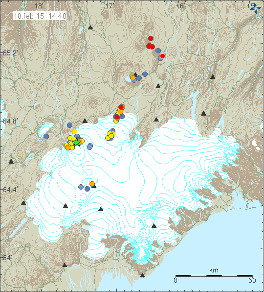
Three green stars showing this morning.
http://en.vedur.is/earthquakes-and-volcanism/earthquakes/vatnajokull/
It’s barely still going according to the Nordurflug company who does tours over it.
It looks like the subsidence gps on the glacier surface in Bárðarbunga caldera is up and running again. I think they have had a few problems with it over the last week, hence some of the very flat lines it has been showing. It is going to be interesting to see if there is any hint of any inflation over the next few days.
It’s starting to show signs that an inflation cycle is beginning, the cyclical pulses have been overidden. The reappearance of M3> at BB and more activity along the dyke are signs of pressure as Jon predicted.
The next couple of weeks will I suspect be very interesting.
The women they searched for was found safe in a cabin north of Mýrdalsjökull glacier.
As for Holuhraun, the power of the eruption is now smaller and appears to be dropping daily. I don’t know how much due to the bad weather in Iceland at the moment, and no trips to Holuhraun at the moment.
Glad it ended well!
I just love google translate: The team in south hasn’t, due to the weather, begun searching for a new wife at the tracks… (icelandic to swedish)
Yes, and say that with the all too familiar accent and you get something like this:
http://www.youtube.com/watch?v=RhRkAzaDuyg
http://www.youtube.com/watch?v=NpYEJx7PkWE
At least that had a happy ending!
Yes, a nice bit of good news.
Surely interesting documentation (if I only could understand Icelandic 🙁 ):
http://ruv.is/sarpurinn/eldgos-i-holuhrauni/22022015
No GPS again…
There is going to be a storm in Iceland from Wednesday to Saturday at least. Wind speed is expected to go up to 20 – 30m/s. It is going to be a snowstorm with a considerable snowfall.
New pictures. People might have to log-in into Facebook to see those pictures.
https://www.facebook.com/helicoptericeland/photos/pcb.10152627904425824/10152627901290824/?type=1&theater
Quake swarm near Upptyppingar and Herðubreiðartögl…
Cheers.
Failed to find this anywhere in the plots when I wanted to check up on it. link to the station or something?
sorry
*you don’t happen to have a link to the station or something?*
Jon, time for an update. The eruption more or less stopped. That is quite an important event/change of situation 😉
The eruption has stopped no shield volcano,just a thick lava field,what a surprise!
I wouldn’t be jumping with joy just yet, IMO are still keeping their options open in todays bulletin –
“ The volcanic eruption has now been going on for almost half a year. The lava flow has decreased substantially in Holuhraun and the rate of the subsidence of the Bárðarbunga caldera has also decreased substantially. Three scenarios are considered most likely:
The eruption in Holuhraun continues until the subsidence of the Bárðarbunga caldera stops. The eruption could come to an end in the next few weeks but it cannot be ruled out that a small eruption
could go on for many months.
The volcanic fissure may lengthen southwards under Dyngjujökull, resulting in a jökulhlaup and an ash producing eruption. It is also possible that eruptive fissures could develop in another location under the glacier. If such an eruption would be prolonged it could eventually produce a lava flow.
Volcanic eruption in the Bárðarbungu caldera. Such an eruption would melt large quantities of ice, leading to a major jökulhlaup, accompanied by ash fall.
Other scenarios cannot be excluded.”
Why joy? I’m sad that this once in a life time eruption came to an end 🙁
For sure I’m happy for the people in Iceland to have better air quality.
But, as we know Iceland, there will be more. We just have to wait a bit.
http://icelandreview.com/news/2015/02/24/volcanologist-end-eruption-not-necessarily-good-news
That seems to me to indicate a split among the scientists,some in the camp of Holuhraun being the main event driving the subsidence at the caldera,the other camp thatthe caldera is the driver and the current eruption just a symptom of greater events occurring within the caldera system?
There is no official announcement about the eruption ending yet. I am going to wait for that until I write about it.
Jón, could you please write something about the higher count oft the dike quakes that went together with decline of the eruption in middle oft january?
http://hraun.vedur.is/ja/Bardarb/bb_lib_mag.html
To me, it seems Baugur is blocked over the time. But the pressure in the dike increased. So the scenario oft new vents open to the south is more common now. What’s your (and others) opinion?
In my humble opinion, if the pressure was still there the eruption would still be continuing. I dont believe it is blocked, it has just calmed down. We have to remember the rising magma found the easiest path was to the north east, until it broke the surface. It all happens in cycles, and this is just another cycle, and now I think it will remain quiet for some period of time.
OK, but the dike is crackling with small quakes as we can see. What is the force behind that when magma pressure is nearly 0 at Holuhraun?
As long as there is any flow at all, heat is being transported forward. This very high heat melts its way upward in horizontal dikes and into neighboring cracks. The result is many small EQ’s fairly close to the surface but mostly still km’s down.
What drives the flow is slow subsidence, now in the western rim of BB.