
Current activity in Bárðarbunga volcano remains the same. The eruption in Holuhraun continues, at bit slower rate now than it was some ten days ago according to latest news. This is not surprising, since last eruption in Bárðarbunga volcano that was like this only lasted for around 8 months. That formed the craters named Tröllagígar (more information at the end of this article). Flow of lava out of the crater is now estimated to be around 60m³/sec. It was also noted in the news that cauldrons in the glacier on top of Bárðarbunga volcano have been getting deeper in past few weeks, this means the area and the volcano it self is getting hotter. This means that magma has risen up along the caldera rim and warmed up the crust. This is important since magma cannot warm up the crust like this unless it is shallow, less depth then 2 km and in some areas less then 1 km. One reason why Holuhraun eruption might be coming to a end is that the magma has found a new and easier path up to the surface. The magma appears to be deep sourced and that is a problem, since it is harder to impossible to monitor and speculate on deep magma chamber. Since shallower magma chambers can often be monitored by earthquake activity, there is no such thing for magma chambers on more depth then 20 km in the crust.
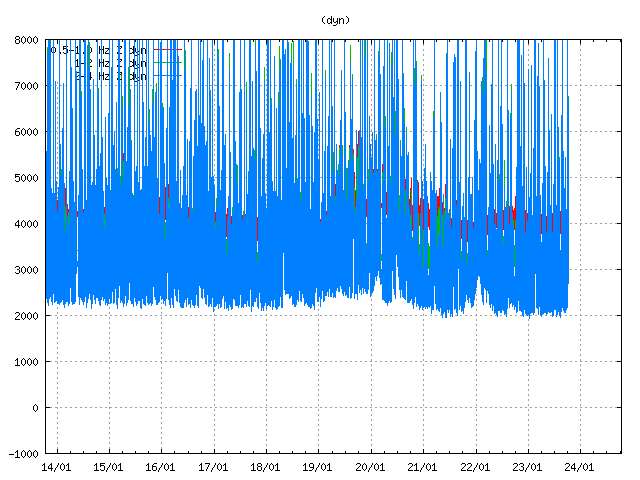
Harmonic tremor in the past few days from the eruption in Holuhraun. Drops in harmonic tremor are sign of drop in the eruption. The eruption is now fluctuating (in my view) that at times stroke activity (the little that is) is possibly stopping at times. Copyright of this image belongs to Icelandic Met Office.
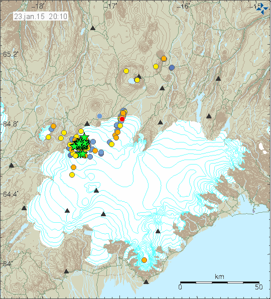
Earthquake activity in Bárðarbunga volcano for the past 48 hours. Copyright of this image belongs to Icelandic Met Office.
Earthquake activity remains around the same in Bárðarbunga volcano for the past 48 hours. There has not been a magnitude 5,0 or larger earthquake in the past 15 days according to latest news. Earthquake activity remains high in Bárðarbunga volcano. This earthquake activity has however been dropping since August-2014 when it was peaking around 12.000 earthquakes a week (around 3000 earthquakes a day).
The rifting event
When the eruption in Holuhraun ends, it is just going to mean that the Holuhraun eruption has ended. The rifting is going to continue for a long time after the eruption has ended. The models that I work with (in my head, I don’t got a supercomputer) suggest that it might migrate south along Bárðarbunga volcano fissure swarm. This is difficult to predict for sure, but there are data (cracks in the ground forming over the past few years) suggesting that a large area is going to rift. This rifting is going to start eruptions, both short and long along this area. Part of this eruption risk area is under thick glacier (Vatnajökull glacier). That is going to start glacier flood that area going to damage everything in there path.
What is also impossible to know for sure is how long this rifting is going to last. Past episodes suggest that active periods like this normally last from 5 – 10 years. Sometimes shorter and sometimes longer, depending on how long it has been since last rifting episode took place. Last rifting episode in this area might been ~100 years ago in part of the system. I don’t know this for sure, but this is what the data suggests.
Tröllagíar crater information
Veiðivötn (need.is)
Vatnajökull national Park (uef.fi, 39 page pdf document)
Old paper and chemical analyse of eruptions in 18th century in Bárðarbunga (or that area). (timarit.is, Icelandic, part in English)
Field trip to Veiðivötn – Heljargjá – Jökulheimar (earth.leeds.ac.uk, pdf file)
Icelandic News
Gosinu í Holuhrauni gæti lokið á næstu vikum (Vísir.is, Icelandic)
Dregið hefur úr virkni gossins á yfirborði (Vísir.is, Icelandic)
Mikil virkni enn í Bárðarbungu (mbl.is, Icelandic)
Donations
I am currently waiting for PayPal to finish validating my new account in accordance with EU anti-money laundry rules. I don’t know how long this process is going to take. I hope it won’t be long. While that happens, I want to point out that it is possible to support my work by buying from Amazon (select your area before you shop) or by support my work directly by bank transfer. Information on donations with bank transfer can be found on “Donations” site. Thanks for the support. 🙂
Comments
Please keep comments on topic (minor off-topic is ok if you get bored, but I recommend youtube or some game if you get bored). Please do not flame. I want to point out that nobody has clear idea what is going in Bárðarbunga volcano. Often nobody knows for sure what is going on in Bárðarbunga volcano.
Article updated at 21:36 UTC.
Is the chance of an eruption in the caldera greater now?
Tyler, It would now seem more likely!
Eathquakes alone can cause an increase in hydrothermal activity
2 earthquakes in 2000 caused
“ydrothermal activity increased substantially in a large area around the two faults. It has been estimated that the thermal power equivalent of the increased flow of hot water to the surface is around 100 MW. The great geyser, Geysir, that gives its name to all the geysers in the world, 30 km to the north of the faults, erupted again, after being more or less dormant for more than half a century. Water level changes in boreholes, observed immediately after the earthquakes, agree very well with the observed mechanisms of the earthquakes, i.e. raising water level in the areas of compression and lowering it in the dilatant areas. The hydrolic pressure change was in the order of 2-13 bars in wells sited only few hundred meters from the fault lines, in the range 0.5 to 2 bars in the next 1-2 km radially out and 0.1 to 0.5 bars as far as 100 km from the seismic faults”
http://hraun.vedur.is/ja/skyrslur/June17and21_2000/index.html
Rising magma may not be the cause of the increase around the caldera
It is magma, this is a volcano.The earthquakes release energy very quickly in a few seconds to a minute, this is not long enough to produce enough heat to melt the base of 800 metres thick ice.Only magma could produce this amount of sustained thermal energy.
It is not the energy from the quake causing the melting
Probably the fracturing allows water a path to deeper magma that it was not exposed to before the crack caused by the earthquake. Would this not result in an increase in activity at an already existing hydrothermal vent that is not 800 m thick? Because that is what is happening, there are no new vents just existing ones getting deeper.
That is a better explanation and is what I read into the paper you posted.But if as the charts you posted previously suggest the seismic energy output is reducing, then the geothermal effect on the glacier should be waning significantly? This seems not to be the case, so this has to suggest the presence of shallow magma , either melting the ice through direct geothermal heating or creating an ever more vigorous hydrothermal system.My view has been consistent that this is a heat driven event caused by a large volume of magma, deep and shallow sourced.
“GPS measurements near northern Vatnajokull glacier show continuing slow deflation towards Bardarbunga” from IMO almost every update they post
http://i59.tinypic.com/2pyuasl.png
Even the beyond the rim is sinking
There is no evidence of inflation anywhere
There is no way you can melt that much ice without steam or being noticed
There is no evidence of any rising magma, all evidence suggests just the opposite
The sink and flow out match perfectly, declining at exactly!! The same rate.
The quake pattern shows a crack starting in BB which sent magma 45km North, not upwards, there was no easy upward path.
This event (leak and sink) is declining so the only thing all of the data is pointing to is this thing ending soon.
Could there be some new event causing this to change, of course there could be but it looks more unlikely every day
There does not need to be inflation for a potential eruption.If the magma is in place, it just needs a lower pressure environment to erupt , either effusively or explosively.The subsidence of the Caldera floor caused by whatever mechanism potentially reduces it’s structural integrity leading to decompression of the magma.Perhaps the magma is sufficiently de-gassed to not have an explosive eruption , so may instead extrude as a dome?
Ian, prior to Holuhraun eruption, there was massive subsidience rifting in the region. A couple days later, the eruption appeared.
In such rifting events, things work a bit different than your normal eruption.
So, think this way. The entire crust is rifting, and as it rifts, it makes magma rise and fill the void. On a few ocasions, it erupts. And during this type of rifting episodes, history teaches us that eruptions and rifting episodes become sequencial over a period of a few years to decades. Of course, it is reasonably to think along this line. So I predict we will see more eruptions.
Ultimately over millenia, Iceland grows upwards and downwards, so any subsidience is temporary at a geological scale. Even in Holuhraun the erupted lava already made the terrain much higher than any subsidience.
On the cauldron events, these are very common in glaciated volcanoes in Iceland, and when they increase so does the risk of eruptions. Example: Katla, Grimsvotn. Sometimes eruptions remain subglacial and you will NOT see any steam, flooding water, or ash. Just harmonic tremor. So, remember there are invisible eruptions, and the IMO has confirmed that some have occurred already under the glacier, under some of these cauldrons. So tha path there is already open.
Your thinking is interesting of course. Magma in these events follows line of least resistance and that is along the rifting region, and I suspect that it is easier to erupt in non-glaciated regions than in glaciated regions due to the ice cap pressure.
Large scale rifting: This is exactly what needs to be look upon. I think the possibilities are several.
1) Further eruptions in the area
2) or further north into Askja or Herdubreid
3) slightly north of Tungnafellsjokull
4) south along Hamarinn, Thordarhyma, Veidivotn, etc
5) in quite opposite spots across the microplates. Namely I think over that spot southeast of Langjokull which seems to show increases tectonic activity
6) of course a regular eruption of Katla, Hekla, or Grimsvotn can also happen, even with more wider rifting than usual.
Hi Irpsit
It makes sense there does not need to be inflation before an eruption, but at Holuraun there was no need for inflation as magma filled the void created by the rifting, therefore no upward pressure, it was travelling along an existing path.
In my mind I think BB caldera may be next to dead and this event has removed whatever pressure there may have been below. That is a massive amount of rock to sink, more than just the caldera. look at the tinypic link above and look close, even the North face has sunk. That is a massive amount of rock above the reserve feeding Holuraun more than 10km x 8km x 10km deep, probably deeper than 10Km. The potential energy has been released and it is all over the landscape in the form of almost 2 km^3 of lava.
I am not saying there may not be eruptions around BB but they would only be small in scale. Why I say this is that there was enough energy released to push this event North by 45km in the past and now it has happened again, this is the path of least resistance now and would be in the future as well, it is the pressure relief valve under the caldera.
Regrettably, the caldera of Bárdarbunga is not “dead” at all.
There was even found magma nearer to the surface than thought before acc. to information by geophysicist and professor at University of Iceland Magnús Tumi Guðmundsson by the end of November 2014. Earthquake analysis indicated a depth of around 1-3 km instead of 5-8 km.
http://www.mbl.is/frettir/innlent/2014/11/24/kvikukerfi_bardarbungu_er_floknara/
no when the crust has ben thinned under a high volume magma cchamber like in bardarbunga something called gethormall upheating happens whiiich heats the crust bye magma and sinces the magmachamber to bardarbnga sits 3 k under the surfaces the crust is thin enough for the magma in the chamber below to fracture the caldera and heatt it to 456 celsiuse which is forming cauldrones in ice and glaciers the deeper the cauldron the hotter is the crust it has nothing to do whit hydrothermial events at all the magma is heatting the crust and is slowly filling the fractures in the caldera the more earthquakes the more fracturing the more fractures in the surfaces of the caldera the more magama rises to fill the fractures which can cause a subglacial eruption sinces the magma is rising slowly in the caldera
I think Jon explains well how it is “more likely”. The fissure eruption decreases as the overall earthquake activity decreases, though it seems to me that there has been relatively more EQ activity towards the fissure over the last couple of weeks. This whole area must be weakened by what’s already happened. Is the weakest spot still the fissure, the callers rim, somewhere between the fissure and Bardar, or somewhere else entirely, or will it slowly just stop? The story goes on – gripping isn’t it!!
It does seem to me that we are ever closer to a new twist in this tale.
Caldera rim! Phone typing 🙁
I have always supported the theory that we will be looking at a much larger area than we are concentrating on now. Jon’s idea that it will go south is interesting and there is data supporting that.
I feel it will trigger activity in wvz and nvz. My reason for that is the continued microplate movement, which is a major factor interrupting direct interaction between the continental plates in this area. It is the reason for the extension from the mar route and the next year should prove very educational as the repercussions of the current event take effect. There is another microplate in the north and at Jan mayen on the Mar.
As a hekla nut it is the wild card here, and there has been quite a lot of strain affecting this unpredictable volcano.
souh of bardarbunga sits a rhyolthic fissure to anhoter volcano thhats connected to bardarsbungas basaltic fissure system in the south west which i dont rember the name on but if the south west fissure system is being reactiveted so will Torfajökull volcano cause in 1477 when a huge eruption at bardabunga happend much larger then the eruption today Torfajökull volcano was active at same periode 1477 which meanss ther gotta be a secret fissure connection
I also think that the microplate movement and the larger scale rifting event are very important.
Re. the southwest fissures of Bárdarbunga: I think it is proven that (basaltic) dykes from Bárdarbunga volcano entered repeatedly the volcanic system of Torfajökull (mostly rhyolitic) which led to the famous mixed eruptions during the Veidivötn and Vatnaöldur episodes, and some others before the time of settlement in Iceland.
Re. the crossing of Bárðarbunga and Torfajökull volcanic systems, see eg. http://www.vedur.is/media/jar/Bardarbunga_kafli20140825.pdf (p.2) or http://www.dmg-home.de/Abstracts/Koeln2007/Goldschmidt2007%20%28E%29/program/abstracts/A1153.pdf
Thank you for the post, Jón. Your interpretation of what has been reported, and the comments by others on here, help me to understand what might be going on.
Fine update, Jon!
Congratulations for this article John, it’s great! 😀
quake swarm is gradualy growing again…
Thanks for the super update, Jon. The information you presented was very helpful in helping me understand what is now going on with Big B. Things do seem to be changing. Now I shall be waiting for the next chapters to unfold as the rifting event continues in the months ahead.
It looks like we are going to see series of eruptions in next ~20 years from this area. I base my view on past history. For instance, a eruption series started in the year 1697, that did not end at least until 1739 (due to lack of data it is impossible to be sure on when the eruptions ended exactly).
What is interesting and there a good chance this might already have started back in the year 2011 when a minor eruption took place in Hamarinn volcano (Loki-Fögrufjöll) under the glacier, or at least that was the first eruption before the main events started to take place (I am not sure).
Also from 1862 onwards, there were several eruptions in the area, for a few decades
1862-1864: Trollagigar, south of Bardarbunga
1874-1875: Askja, north of Askja, and apparently also south of Askja
1910: eruptions in Hamarinn or Thordarhyma
1903. eruption in Thordarhyma
1902- eruption north of Bardarbunga or Grimsvotn
and around more 9 eruptions of Grimsvotn in between
This is about right. See also: http://volcano.si.edu/volcano.cfm?vn=373010
History of eruptions in Iceland during the last 1000 years.
http://icelandgeology.net/?p=765
I’ve never seen a short list like this put together with such brief but noteworthy comments. Thank you, Jon, for another great update!
Morning Jon & everyone. Thanks for the update.
Jon, random question but is that possibly harmonic tremor signal on your geophones or is it merely weather related?
Please could you let me know the link where I also could have a look at the signal from Jon’s geophones.
Many thanks.
http://www.jonfr.com/webicorders/tremoren.htm
It’s the weather. A storm is expected in next 24 – 48 hours in Iceland.
Hey Jón!
Thanks for the good article.
Question on the updates in it:
I would kindly ask you, if you could mark the word/sentence that you updated later on in the text?
I get the twitter-news when a new article is up and read it most often immediately. Next day I see you updated it. But I’m not sure where. 🙂
Often this are just minor spelling corrections or word correction. I do mark it clearly when I add new information to the article.
Ok, I see!
Thanks Jón!
Magnitude mb 4.6
Region ICELAND
Date time 2015-01-24 07:25:51.6 UTC
Location 64.78 N ; 17.24 W
Depth 10 km
EMSC
Thank you Enno for the link. 🙂
First of all, many thanks for such an excellent post and also for the great and concise schedule of volcanic activities over 1100 or so years. The earthquake ar
ound 7:25 this morning has now been upgraded from 4.5 to 4.9. Given how large it looked on the drumplots I am not surprised to see this at all.
M4.9 is the strongest eq this year.
There was a 5.1 this year already, so the 2nd strongest.
Paypal has told me that I need to meet the limit of €2500 (18.609,72 DKK) before they start to check my documents that I sent them. For that reason I have added the Paypal button, since if I don’t start counting to that limit they won’t check my documentation until sometimes in the next 30 days.
This also means that once I hit this pre-set limit the account won’t be able accept donations until Paypal lifts those limits.
Is that the same as $1000 USD?
That is around $2.814,84 at today exchange rate. Regardless the document is going to be checked and confirmed (I hope) in next 30 days.
Are there any photo’s from the fly over the Big B that you can share with us Jon?
A photo taken on January 21 during a surveillance fligt of the Icelandic Coast Guard (Photo by: Morten S. Riishuus)
http://thewatchers.adorraeli.com/data/uploads/MoRi_4624.jpeg
Article: http://thewatchers.adorraeli.com/2015/01/24/very-high-values-of-so2-emissions-from-holuhraun-eruption-site-iceland/
And the original photos on the website of University of Iceland: http://earthice.hi.is/bardarbunga_holuhraun (21. January, scroll down)
Some ash fall in cam 1 now?
I think, I saw a bit of ash around Baugur’s crater rim, in one of the last videos. But really just a small portion which would be produced eg. by fire fountaining.
At the moment, I don’t see any ash on the webcams, just gas emissions as usual. The gas emissions must still be very high at the eruption site, though they are mostly now down in the inhabited areas. See also: http://icelandreview.com/news/2015/01/19/volcanic-gases-cause-health-problems
Dear everyone,
I found a link to a site called fire-earth: https://feww.wordpress.com/2010/04/20/icelands-bardarbunga-may-be-erupting/
The article is from april 2010 and gives an interested overview of potential future eruptions (Bardy is on number 4).
Kind regards,
Henk Weijerstrass
Holland
Iceland Eruptions says:
A strange contradiction with earlier news….
The latest Factsheet (http://avd.is/en/wp-content/uploads/2014/09/Factsheet_Bardarbunga_20150123.pdf) says:
“Insubstantial changes have been in the volcanic eruption in Holuhraun over the last few weeks.”
A volcanologist, flying over the erution says:
“It is clearly slowing down. We see that it had a major change in the last ten days. We have never seen before such a major change in such a short time. The walls have sunk in the crater for some ten to fifteen meters. There is much less liquid quantity of magma inside the craters themselves” volcanologist Ármann Höskuldsson says.
I read that as no contradiction, they say the same thing from two points of view. One is statistical the other is from a helicopter. I read somewhere that a northern section of Baugur’s retaining wall has collapsed, or was breached. That gap emptied the lava lake down by 10-15 meters. Otherwise, the eruption has not changed.
Now this is an interesting point. As we have seen lately, at the north end of Baugur, a small crater opened up. With the original north crater rim separating it from the lava lake. On the last videos/photos, I observed that that northern rim has collapsed and the lava lakes is now longer than before, extending to the rim of the new small crater. But I did not see any new outflow, which would support your SteveG theory of decreasing the height level of the lava lake. More pictures and videos are needed. But the original outflow to the northeast is still active.
The information about decreasing lava level within the crater is not from SteveG, but from the Icelandic volcanologist Ármann Höskuldsson.
Sorry, didn’t read this correctly, I saw now that SteveG thinks that the lava level within the crater is down because of a new breach in the crater rim.
But I also read, that the lava stream building up a crust rather fast would be a sign of reduced magma output.
And this is what geologist and professor Magnús Tumi Guðmundsson, also University of Iceland, says re. a reduced lava production and probable duration of the ongoing eruption in Holuhraun: http://icelandreview.com/news/2015/01/24/geophysicist-holuhraun-eruption-could-last-months
It’s OK. On the satellite pictures, the covered lava tubes are quite noticeable. Both lava output and activity in the dike system are closely correlated to the intensity of the EQ’s at Bardarbunga. As long as the EQ’s keep up, so will the eruption.
Craving volcanic action? Cool video showing explosive eruption of Mexico’s Volcan de Colima: http://www.washingtonpost.com/blogs/capital-weather-gang/wp/2015/01/22/two-incredible-eruptions-of-volcan-de-colima-caught-on-webcam/
Rather impressive pyroclastic flows. Hopefully, nobody was too near them.
Thank you, for sharing, Karen.
You’re welcome. Yes, I thought about that too, hoping that no one came to any harm. Is always a balance to be struck between fascination with the science of natural forces and real world consequences.
Sunday
25.01.2015 18:27:24 65.040 -16.550 11.2 km 4.1 50.5 2.6 km E of Dreki
Updated: Sunday
25.01.2015 18:27:17 64.656 -17.389 3.7 km 4.6 99.0 6.8 km ENE of Bárðarbunga
Is Dreki a new area for earthquakes ?
Not really, it is part of the Askja volcanic system and there have been quakes and quake swarms there from time to time.
See eg. Jón on quake swarms in 2011 in the Askja region: http://icelandgeology.net/?p=876
I’m wondering if it’s so windy at Askja for real…?
http://hraun.vedur.is/ja/vatnajokulsvoktun/ask1_trem.gif
Why is this the only SIL-station which is so highly affected?
Acc. to IMO it is 24-28 m/sec on average, this is really stormy.
http://www.vedur.is/vedur/spar/thattaspar/#teg=vindur
Station next to Askja (Icelandic Road Admin): http://www.vegagerdin.is/ferdaupplysingar/faerd-og-vedur/austurland/linurit/st052.html
Thx for the links, Inge!
High wind speeds keep going on there.
There was a new report on gas research at Holuhraun this evening in RÚV tv: http://ruv.is/sarpurinn/frettir/25012015-8 (from 08.50 onwards). The results of newly measurements on gas emissions there are 90 % H2O, 3-4 % CO2 and SO2 each, and minimal quantities of HCL (0,05%), HF (0,05%) and CO (0,001 %). 14 scientists from Iceland and other country were at the eruption site during this week, for the first time after a 6 week break.
In an interview, one of the scientists emphasized, that the sulfur compounds are still a matter of concern. They can change into pm (particle matter), as such be redistributed over long distances by the wind, and have a negative influence on health, environment and even climate. The quantity emitted at Holuhraun surmounts by far emissions of other comparable volcanoes like Etna, Kilauea and even of the Laki eruption series during the 18th century.
BTW: There is an error in the above: It was 0,5% each of HCl and HF.
That is quite a high H2O content and the HCL is not that low either? http://volcanoes.usgs.gov/hazards/gas/ , gas composition is similar to the convergent plate example in this article a certainly unlike the Hawaiian example?
It does not surprise me.
I felt for several times not only the intoxicating SO2 gas, but also some Cl gas. So, they have confirmed the rather high amount of chroline released.
IngeB: why do you say these amounts are higher than Laki? Dont understand. Laki released much higher levels of gas than Holuhraun per same time frame.
http://www.ipgp.fr/fr/andesitic-magma-degassing-investigated-through-h2o-vapour-melt-partitioning-of-halogens-at-soufriere
@Irpsit.
Depends on how you look at it. Seemingly, fluor levels were a lot higher during the Laki eruption, but not the SO2. These are informations by geochemicist Evgenja Ilyinskaja (working for University of Cambridge).
The interview was with television news of RÚV on January 25. http://ruv.is/sarpurinn/frettir/25012015-8 (from 8:50 on). The speaker says around 10:12: “Ekki hefur komið svo mikið af brennisteinsdíoxidi frá Skaftáreldum 1783.” Which means exactly the above, as you certainly know, Irpsit. And Evgenja says: “We höfum ekki séð svona eldgos í manna minnum.” (We never saw such an eruption as far as history goes.)
@JB
Magma mixing and andesite as a result? http://www.nature.com/nature/journal/v461/n7268/full/nature08510.html
There is the Hreppar microplate moving and turning and touching both Hekla and Bárðarbunga volcanoes. I also read somewhere, that this microplate is dipping under Hekla / the Eurasian plate, so that there would be a mini-subduction zone in the middle of Iceland. And Hekla seems a) to produce an unusual quantity of andesite in comparison to other Icelandic volcanoes, but b) also rhyolite and basalt.
Not necessarily andesite, but evolved magma and is there shallow magma reservoir degassing infiltrating the dike?
Open system degassing like in your above literature?
On some experiments with open system degassing: http://adsabs.harvard.edu/abs/2009AGUFM.V21C2006P
I thought, open system degassing would reduce the explosivity of eruptions. http://all-geo.org/volcan01010/2012/12/gas-makes-subglacial-rhyolite-explode/
Soufrière Hills, on the other hand, is a highly explosive volcano with a bad reputation re. production of pyroclastic density currents…
Reducing the chance of a potential explosive eruption is the upside of all this gas output, the downside of this is there is a lot of gas to begin with ,including the main explosive ingredient of rhyolite H2O.At one stage it was 30000 tons of SO2/day and that is less then 10% of the total gas volume, so serious levels of magma must be present, at least at depth and only a relatively small percentage of which has breached the surface?If the current SO2 was say 10000 tons/day then at 4% that would be 250000 tons/day total gas and 1250 tons of HCL that is a lot of chlorine!
Thank you, Jon for the regular updates.
Haven’t had time to analyse the eqs but there seems to be a lack of eqs between 3M to 4M. Is this due to local geology or an instrument glitch?
Could be due to the bad weather, there was a storm in Iceland which could cover up earthquakes. But I am not sure if it influences also the bigger ones. Perhaps more difficult to know where the hypocenters are.
There were over 200 people fast in a restaurant north of Holtavörðuheiði because of the snow storm ( 25-27 m/sec. as an average!). http://www.visir.is/rumlega-200-ferdalangar-vedurtepptir-i-stadarskala/article/2015150129332 One of them was the opera singer Kristján Jóhannsson who was thinking about an improvised concert to hold spirits up.
😳 typo on the email address.
The comment stuck in moderation due to the typo was a query on the apparent lack of 3M to 4M eqs (but not done a full analysis). Is this due to local geology or an instrument glitch?
Jon, feel free to remove the duplicated comment. Hope all us well with you.
I just looked at IMO table for Vatnajökull – earthquakes >= 3.0 during the last 48 hours.
There are only 3 EQs 4.0 to 4.9 out of 15 EQs >= 3.0 (20%). But this is not statistically significant (based on N=15 only).
I meant to say this is not significantly lower than the baseline of 36.3% over the first 100 day period.
Report with photos from IMO / Univ. of Iceland re. the fly-over on 21st: http://en.vedur.is/media/jar/Notes-from-surveillance-flight-to-the-eruption-site.pdf
Does anyone know what the observations of the cauldrons and BB GPS station showed?
From the Almannavarnir report on 23/1/15 (http://en.vedur.is/media/jar/Factsheet_Bardarbunga_20150123.pdf):
“Over the last few weeks the geothermal cauldrons in Bardarbunga have enlarged. “
As far as I know, there is still no connection to the BB GPS station.
But there are results from a flyover on the Icelandic version of Bárðarbunga page of University of Iceland /Earth Sciences, they are though from December 2014: http://jardvis.hi.is/bardarbunga_desember_2014
Difference between mid August and end of December was acc. to this 59 m of subsidence.
I was referring to the last paragraph of the report you mentioned regarding the flyover on 21st January.
“During the day assistance was also provided to the gas monitoring team from BGS, airborne collection of gas samples from inside the plume. Observations were also made on ice cauldrons and Bardarbunga GPS station, and the ice dam in Jökulsá up and downstream from Grimsstadir.”
I see, and found new data, again on the Icelandic page of Univ. of Iceland: http://jardvis.hi.is/bardarbunga_holuhraun
The most important informations are:
– The lava has become thicker, up to 20 m in many places and up to 40 m now near the vent.
– Whole lava quantity is now by 1,4 km3
– The subsidence is now up to 60 m within the caldera.
Thanks Inge for the great link!
@IngeB – Thanks for the link
I don’t know how many of you subscribe to the fellows Youtube channel. I think he does great work plotting the earthquakes in Bardarbunga.
https://www.youtube.com/channel/UCft1DTmR-ulbJix1SvKLL9A
Marion
Yes, he has been doing this for a long while now and he posts to VC. His models are very good and he doew focused midels by area too. Eg they highlight that the eq patterns are predominantly in established areas of bb. the nil eq areas within the caldera are thought to contain magma chambers as seismic s waves do not travel through liquid magma.
If a known eq happens at x hours and is registered at several sil stations but not others, then there is magma between the epicentre and the sil not recieving the s wave. The sheer volume of eqs in this event has made analysis in this way particularly difficult.
Looking at M3+ is insufficient, since <M3 are more likely where there is magma.
Yes, the cause of the m3+ EQ’s are ground drops and shifts of much greater magnitude. These signify the slow collapse of the mapped sections of the caldera rim.
Lateral magma movement in the dikes generally shows up as minor mag 0-2.
http://www.academia.edu/754308/Formation_of_caldera_periphery_faults_an_experimental_study
Thanks for that article JB. Their scenario for pure caldera collapse is informative. What we have at Bardarbunga is an asymmetric evacuation of a deep magma chamber. Most magma appears to be exiting at 9+ km depth towards the southeast. But the subsidence is mainly towards the north of the caldera. Don’t know why.
New article about Bárðarbunga volcano is up. 🙂
Cheers!