
The eruption in Holuhraun continues at the same phase as it has been doing this week. Far as I know there has not been any reports about changes in the news or in the reports from Icelandic Met Office. SO2 continues to be a problem in Iceland depending on wind direction. Both to people and animals.
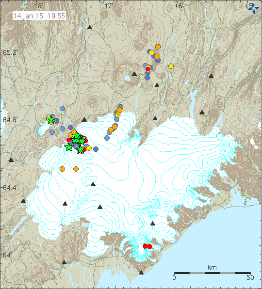
Earthquake activity in Bárðarbunga volcano for the past 48 hours. Copyright of this image belongs to Icelandic Met Office.
Strong earthquake activity continues in Bárðarbunga volcano. Strongest earthquake in the past 48 hours had the magnitude of 4,7. Many smaller earthquakes have been also taking place in Bárðarbunga volcano and there are no signs that earthquake activity is about to end. Even if it has dropped from it’s peak in September to November.
According to Channel 2 (Stöð 2) news, Bárðarbunga volcano has been preparing for an eruption since the year 1974 at least (this might have started years earlier without anyone knowing about it), possibly earlier. This means there is huge amount of magma inside the volcano and possibly in the deep root system (my view) that is ready to erupt. There is also high risk of eruption taking place under the glacier, that risk is going to increase once the eruption in Holuhraun stops. Since it is clear in my view that Holuhraun cannot erupt (at least there is a good chance of it) all the magma that is now in Bárðarbunga volcano. There is always the question if all that magma is going to erupt, the chance of that are good based on current factors. That might change without warning.
Icelandic news
Hætta gæti aukist á öflugu sprengigosi í Bárðarbungu (Vísir.is, Icelandic, images)
If the Caldera has been building up for an eruption for decades, the that has to indicate a shallow deposit of evolved magma? Surely a basalt based eruption does not need decades of build up as Holuhraun proves , a few weeks to days or ours is all that is needed, nor could it cause the huge quantity of 4 mag+ earthquakes? The fissure eruption quake swarms were smaller earthquakes.
I don’t know about the earthquakes.
But I found a paper which seems to prove a connection between an upheating volcano and rhyolite production. http://www.sciencedirect.com/science/article/pii/004019519390139B The paper is about the Taupo Volcanic System in New Zealand and in the abstract it says: “The TVZ’s crustal heat transfer of about 5650 MW is anomalously high and is a result of production of large volumes of dominantly rhyolitic magma by crustal anatexis.” So that your hypothesis seemingly is scientific after all.
And aditionnally, during the interview with the geologist Ármann Höskuldsson, linked in above by Jón, some interesting remarks came up. http://www.visir.is/haetta-gaeti-aukist-a-oflugu-sprengigosi-i-bardarbungu/article/2015150119483 (it is not yet translated into English) They discussed what would happen when the Holuhraun eruption waned, and Ármann mentioned a heightened danger of a bigger eruption in the main volcano Bárðarbunga. Ármann says that the volcano has been collecting magma now since the 1970s at least. And in the end he says: “Það er mikil kvika búin að vera á ferðinni og svona kvika er nógu heit til þess að geta brætt umhverfi sitt og búið til meiri sprengivirkari kviku, sem er bara ekki alveg nógu jákvæt.” (which means in English:” There is a lot of magma under way and such magma is hot enough to melt its surroundings and to fabricate a magma of a more explosive character, which is actually not really good.”)
Well there you go , there is a method to my perceived insanity after all.
That may seem so … 😉
I agree with you about the Holuhraun lava and about the possibility of there being evolved magma in Bb. The former has been too young for it (all) to have come from Bb. But I am not sure I understand what you have in mind about the earthquakes: the Gudmundsson et al. paper back in September argued that these were largely tectonic and that they were the cause of the movement in the caldera. This leaves open the possibility that there was a causal relationship between the tectonic rifting, the deeper earthquakes and the magma injection, and also between the cone sheets/ring dikes and the tectonic movements.
It’s all connected in my opinion, the earthquakes started with the deep magma injection, so that is the primary driver, via an evolved heating shallow magma reservoir?
Most posters here seem to be thinking that the primary driver of the activity is the subsidence, or some outside regional stress field.I think the the primary driver is the up welling of magma deep under the caldera and this in conjunction with a highly evolved upper magma deposit is causing the subsidence and the regional stress.But I have not been right so far, so my opinion is of limited worth except for the purpose of discussion.
I agree that it’s all connected. What I wonder is whether the rifting can be, and indeed *was*, caused by the magma injection. There are two questions there and it’s the first, the in-principle question, that I am not sure about. Another way of putting it: is the spreading of the MAR (which is what the tectonic rifting near BB is) caused by magma injections such as we are seeing at BB?
Also, the “via an evolved heating shallow magma reservoir” bit seems to me not to fit with the chemical analyses of the Holuhraun lava.
Holuhraun would be from the deep source magma that has bypassed the upper reaches of the Caldera in the most part, the upper magma deposit is primarily separate from the magma at Holuhraun but there maybe a casual link as it migrates along the dike.The rest of the deep sourced basalt is interacting with the shallow caldera, either through direct mixing or passive heating.That is my theory.
@Andrew , should of pointed out that the statement ,”via an evolved heating magma reservoir” was referring to thermal energy transfer not physical magma.
From the abstract of the Gudmunsson et al. article, ‘Dike emplacement at Bardarbunga, Iceland, induces unusual stress changes, caldera deformation, and earthquakes’, Bull. Volcanol. (2014), 76: 869:
“We infer that the strike of the dike changes abruptly at
a point, from about N45°E (coinciding with the trend of the
EVZ) to N15°E (coinciding with the trend of the NVZ). This
change in strike occurs at latitude 64.7°, exactly the same
latitude at which about 10 Ma dikes in East Iceland change
strike in a similar way. This suggests that the change in the
regional stress field from the southern to the northern part of
Iceland has been maintained at this latitude for 10 million
years. Analytical and numerical models indicate that the dikeinduced
stress field results in stress concentration around
faults and particularly shallow magma chambers and calderas
in its vicinity, such as Tungnafellsjökull, Kverkfjöll, and
Askja. In particular, the dike has induced high compressive,
shear, and tensile stresses at the location of the Bardarbunga
shallow chamber and (caldera) ring-fault where numerous
earthquakes occurred during the dike emplacement, many of
which have exceededM5 (the largestM5.7). The first segment
of the dike induced high tensile stresses in the nearby part of
the Bardarbunga magma chamber/ring-fault resulting in radially
outward injection of a dike from the chamber at a high
angle to the strike of the regional dike. The location of maximum
stress at Bardarbunga fluctuates along the chamber/
ring-fault boundary in harmony with dike size and/or pressure
changes and encourages ring-dike formation and associated
magma flow within the chamber. Caldera collapse and/or
eruption in some of these volcanoes is possible, most likely
in Bardarbunga, but depends largely on the future development
of the regional dike.”
A very interesting study would be a geochemical and petrological analysis of the very first lava erupted at Holuhraun. Maybe one could identify a trace or a more clear sample or some kind of mixed lava from the first contact of deeply sourced basalt with the BB magma chamber. If it’s cooking there since 40 years it certainly has changed it’s composition to a more evolved magma. Have there been taken any first samples?? Then it is quite obvious that the dike formed and the geometry of the dike only tabs now deep sourced basalt, with some of the basalt still using the original path from the very beginning (EQ only at BB) and maybe more or less having an influence on the shallow magma chamber. JB, this sounds quite good, but it seems that everything is connected to each other. The rising of the magma/plume was enabled through the tectonic pattern. Then causing additional stress up to creation of the NE dike emplacement, BB rumbling along while rifting is occuring.
The next question is, has this type of activity occurred in historic eruptions before scientific monitoring and led to eruptions outside of the Caldera without significant glacial melt? Or is this an event that has not occurred in thousands of years and would lead to loss of the glacial ice cover on the Caldera and a possible large eruption from the caldera?I have not seen any evidence of more evolved magma at Holuhraun, but the dike is probably not mixing directly with an evolved shallow magma body.Two events one feed source?
I know the Cambridge University geologists were very quickly on site when the eruption started (as they were in the area servicing their seismometers), and they certainly took samples in that first week.
My recollection is that I read reports (presumably still floating around on the internet) of early analyses which showed that the lava is not particularly evolved, at least not sufficiently to indicate that its main source was BB’s chambers.
This recollection gains some support from the Freysteinn Sigmundsson et al. Letter to Nature 1411, 15th December 2014 “Segmented lateral dyke growth in a rifting event at Ba´rðarbunga volcanic system, Iceland”
“The volume decrease beneath the caldera tracks the volume increase of the dyke for the first week of the activity. The volume decrease then decelerates to less than half the previous rate, although the dyke volume increase continues at the same rate. This suggests inflow of magma from an underlying deeper source after the first week, which is not visible in the geodetic data” (p. 3).
@JB on the relationship between tectonic and volcanic seismicity, the following is interesting:
“In essence, the dyke is captured by the plate spreading field once it is sufficiently far fromthe Ba´rðarbunga central volcano, which is located to the west of the central axis of the plate spreading model invoked” (p. 4).
Some more groups of petrologists have been working on Holuhraun samples: petrologists of university of Iceland, eg. Thor Thordarson and also from the French Université de Clermont-Ferrand http://www.univ-bpclermont.fr/article2751.html . So a lot of results will be published in the future. There were some abstracts up to now, eg. in the afore mentioned paper http://www.jfi.is/wp-content/uploads/wp/Haustr%C3%A1%C3%B0stefna-2014-%C3%81gripahefti1.pdf (on the petrology see eg. p.5) . And at the beginning of september: http://earthice.hi.is/petrology_holuhraun_lava_gudmundur_heidar_gudfinnsson_and_sigurdur_jakobsson
Data re. major, minor and trace elements in comparison for the first 50 days of the eruption are to be found pn p.18 of the a.m. paper: http://www.jfi.is/wp-content/uploads/wp/Haustr%C3%A1%C3%B0stefna-2014-%C3%81gripahefti1.pdf
Sorry, meant “on page …”
I can’t interpret the data, but to me there seems to be twice a slight change in trace element composition: after four days and back after another four days and around the 50th day. A.o. is the barium content higher after four days and in the end of the period.
If we could imagine the bb caldera without the glacier we could analyse whether its formation has been solely due to massive eruptions (we know that these have occurred from bb lava being found at the Icelandic coasts), or to subsidence cycles with periodic eruptions, in which case the size of the caldera may not be relevant to the size of any eruption.
Sadly subglacial activity that are pre instrumentation goes unrecorded.
Jon is quite right about the age of the cycle we are viewing. The current event will not be the end even if a significant eruption takes place since the causal agent is plume ‘weather’ related. Maybe someday science will be able to send instruments down, I’m sure they’d find a way if it was oil or gold down there.
There is!
So maybe we should bring the rumor into the world that there is gold and oil indeed! Just to speed things up a little…
There are more often diamonds found in the neighbourhood of volcanos (or where those have been and nowadays are eroded) than anywhere else. Thats no rumour.
But I have to admit, maybe not listened carefully enough on the last documentary about it. 🙂
Gizmo, you are right. Diamonds are found in special volcanic rocks (Kimberlites) or somewhere down the river, eroded in placer deposits. They come up from great depth in diatremes, explosive volcanic pipes, with great speed, otherwise if they would be tramaported slow, they would just turn into graphite. Sadly, Holuhraun is not deep enough and too slow 🙁
on this
I FOUND SOMETHING GREAT!
http://www.smithsonianmag.com/science-nature/diamonds-unearthed-141629226/?no-ist
A gem of an article.
Interestingly almost all the diamonds dated are old, in most cases billions of years. That would suggest that the conditions to form them are not favourable enough anymore, or they are no longer brought to the surface by the needed special kind of volcanic eruption.
http://geology.com/articles/diamonds-from-coal/
All it would take is a photo of a Geologist holding up a gold nugget and they would be selling shares in Bardarbunga Mining Corp in no time!
Thursday
15.01.2015 12:52:57 64.662 -17.455 4.6 km 4.3 99.0 4.2 km NE of Bárðarbunga
Thursday
15.01.2015 11:24:11 64.673 -17.452 8.5 km 4.0 99.0 5.1 km NE of Bárðarbunga
I have been reading the comments since the eruption started, I am not a scientist nor do I know anything about volcanism in general I’m just interested in science. I live in NY. My question is really an observation, about a year ago in the northern part of Iceland there was a swarm of earthquakes of thousands of quakes over a 3 to 4 month period and then it stopped, could that have been the trigger to move lava with BB the most vulnerable for an eruption even though it is at opposite ends of the Island?. Don’t laugh guys and ladies just wonder, go easy on me.
There have been a number of articles about swarms in the TFZ in 2013, see
http://icelandgeology.net/?p=3591
and more.
Thank you Porsche, I may not understand it fully, but I thought about that particular swarm as significant and within a few months of the start of this eruption. I don’t fully understand the relationships of all the interconnection of the volcanic system in Iceland but with the distance the connection would appear to be a stretch. It just seemed that that particular swarm to be so active at the time and just stop with no apparent corresponding activity reported anywhere else was interesting to me. A few months after it ended BB woke up, I’m sure it is all coincidental. Thank you for responding.
The magma might not being supplied into Bárðarbunga from the north of Iceland, quite the other way round. As the hot spot, ie. the mightiest provider of magma from deep within the earth, from the mantle region, delivers the magma esp. to the mid of Iceland, and very probably from there it flows within very deep seated lateral channels to the tips of the island. But perhaps there is also a special regional dyke in the TFZ region.
But on the other hand, there is a connection via the Mid-Atlantic-Ridge between all the rifting systems within and around Iceland. So that scientists – among others Magnús Tumi Guðmundsson, found out that Vatnajökull volcanic activity is mostly occuring in cycles, periods of high activity alternating with periods of low activity. And this is further connected to rifting – which is happening a.o. in the region you named, Vinny, the TFZ. And this rifting as we also saw now, caused earthquakes swarms, also very big ones. And a rifting period may continue over many years, so, yes, probably there is a connection between the two, and you saw that right.
The way I see it ,is Bardarbunga is located over a weak spot in the earth’s crust and this system has evolved as a mechanism to recycle this excess heat via a dike system and also through magma evolution, similar to calderas in other parts of the world.
The paper I was referring to (abstract): http://geology.gsapubs.org/content/26/10/943
Vinny, you are right in observing this. And Ingi just gave you the explaination why.
In Iceland about every 130 years, roughly, there is increased volcanic activity lasting a couple of decades, and during that time, there are some of the largest earthquakes in the Tjornes and South Iceland Seismis Zone, and also large volcanic activity around Vatnajokull, but also elsewhere across Iceland,
Last period was roughly around 1860 to 1900. We might be entering another of such periods after a relatively calm period last century.
What have we seen so far: two large seismic events in SISZ in 2000 and 2008, the eruption of Eyjafjalljokull and the restlessness of Katla, then the activity at Hamarinn and Tjornes and Askja, the largest eruption of Grimsvotn in 100 years (and largest since Askja eruption in 1875), and now the eruption at Holuhraun, the largest lava eruption on the world since Laki in 1783.
Much more earthquake and volcanic activity should be expected between now and 2030 or 2040, and by this I mean more than the average, and some events will certainly be large and historical, just like Holuhraun is being.
I want to thank everyone who has responded to me and have been tolerant of my ignorance on this subject. I’m getting an education from all of you and I have been an will continue to read the links although I know most of it will be over my head.
Can someone recall the eruption that buried the capital or near the capitol around the late 1960’s or in the 1970’s with large amounts of ash. Can you recall the name of the volcano involved. In reading your comments it never is referenced as a significant eruption and perhaps it didn’t last long. Perhaps I have the wrong country. I just remember the videos which were amazing.
I was not the capital (Reykjavík), but the town of Heimaey on the Westman Islands which was covered by lava and ash in an eruption 1973-4. http://volcano.si.edu/volcano.cfm?vn=372010
But in the case of Heimaey, it was mostly an effusive eruption during which lava covered big parts of the town and the big fishing harbour could just be saved in the last second by spraying tons and tons of seawater onto the advancing lava front. Today the town in blooming again with about 4.000 inhabitants.
On the other hand, in 1995, the volcano Soufrière Hills in the West Indies produced a big explosive eruption covering the capital of the island Monserrat in ash, luckily the inhabitants had evacuated in time. The town couldn’t be saved and is now in ruins, overrun again and again by the pyroclastic flows produced regularly by dome collapse. http://volcano.si.edu/volcano.cfm?vn=360050&vtab=Eruptions
I think you mean Heimaey?
It’s an island in the southwest of Iceland. But the pictures were going around the world as the Eldfell-Volcano was active in 1973.
http://volcano.oregonstate.edu/vwdocs/volc_images/europe_west_asia/heimaey/heimaey.html
Irazu covered San Jose, Costa Rica in ash in 1963. Perhaps that’s the capital you’re thinking of.
Thursday
15.01.2015 20:06:18 64.668 -17.438 8.6 km 4.1 99.0 5.2 km NE of Bárðarbunga
Here is the abstract of a description of an Icelandic caldera magma chamber which could be in some way similar to the one to expect within Bárðarbunga. http://petrology.oxfordjournals.org/content/55/9/1865.abstract It is exposed within the eastern wall of an eroded and partially submerged caldera in the East Fjords of Iceland, actually not far from Vatnajökull and about 20 km to the east of the town of Höfn. The caldera has an age of about 6 mill. years, it is the caldera of Lón and part of its eastern wall, ie. part of the former magma chamber, is called Austurhorn or Eystrahorn. Some pictures in Wikimedia: http://upload.wikimedia.org/wikipedia/commons/2/2e/Fj%C3%B6rur.JPG and http://upload.wikimedia.org/wikipedia/commons/4/4b/Eystrahorn.JPG
Friday
16.01.2015 17:38:17 64.670 -17.360 1.1 km 4.4 50.5 8.6 km ENE of Bárðarbunga
Friday
16.01.2015 18:53:44 64.665 -17.414 7.1 km 4.3 99.0 6.1 km ENE of Bárðarbunga
Friday
16.01.2015 17:43:53 64.662 -17.367 0.9 km 4.0 99.0 8.0 km ENE of Bárðarbunga
Friday
16.01.2015 17:38:19 64.667 -17.384 7.5 km 4.5 99.0 7.4 km ENE of Bárðarbunga
New article is up on Bárðarbunga volcano. Please note the change in scheduled updates about Bárðarbunga volcano.