
This is current status on Bárðarbunga volcano on 10-October-2014.
- There is no change or little in the eruption in Holuhraun far as I know. Visibility has been low today due to bad weather and snow.
- Largest earthquake today had the magnitude of 4,8 at 11:26 UTC. Second largest earthquake had the magnitude of 4,7 at 02:24 UTC. Other earthquakes have been smaller.
- Earthquake activity is increasing in Tungafellsjökull volcano. Current idea about this activity is that it is responding to tension changes in Bárðarbunga volcano. I don’t know how good this idea is. It might explain some of the earthquake activity. I am unsure if it explains all of the current earthquake in Tungafellsjökull. Currently I am just waiting to see what happens next with this volcano.
- Earthquake activity along the dyke was minimal from what I can tell. Most of it took place under the glacier and that might not be a good sign if an eruption starts in that area. Since it would start a glacier flood and later a minor volcano ash eruption.
- No further reports far as I know about current status in Bárðarbunga volcano.
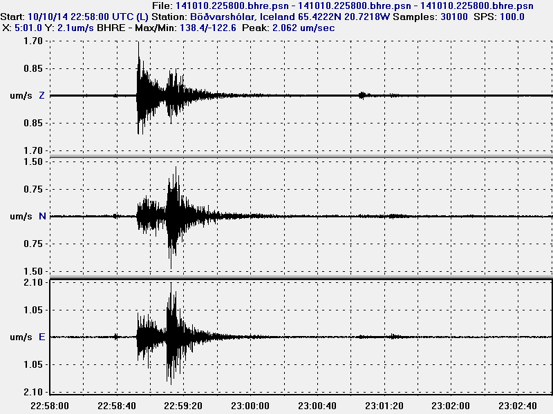
Earthquake from Tungafellsjökull volcano at 22:58:28 UTC. There is some signature different in the earthquakes and the one from Bárðarbunga volcano. The main different at the moment is that the earthquakes in Tungafellsjökull volcano appears to be more tectonic and not due to magma movement. That has however been changing since the earthquake activity changed. Latest earthquakes show less pure tectonic activity than before. It is my assessment that magma might be on the move in Tungafellsjökull volcano. There is currently nothing to suggest that an eruption is going to take place even if that is the case. This image is released under Creative Commons Licence. Please see CC Licence for more details.
Saturday 11-October-2014 update
- No change reported in the eruption according to the news today. The eruption fissure is now one 400 meter long fissure and all the craters that where in that area have merged together into one crater.
- Largest earthquake today had the magnitude of 5,0. Second largest earthquake had the magnitude of 4,7. Other earthquakes have been smaller in magnitude.
- New video of the eruption can be found here on Vísir.is. Audio and text is in Icelandic.
- The eruption might last for months according to scientists in Iceland.
- When scientists flew over Bárðarbunga volcano on Friday they noted some new cauldrons in the glacier. I suspect this has more to do with minor eruptions in the area rather then hydrothermal or hot spring activity. Such activity cannot be ruled out and possibly is taking place along the dyke. If any hydrothermal activity is taking place in Bárðarbunga volcano it means that magma has now reached depth of 1 – 2 km or less.
Sunday 12-October-2014 update
- Largest earthquakes on 12-October-2014 had the magnitude of 5,2 and the second largest earthquake had the magnitude of 4,7.
- Slightly higher earthquake activity has been detected today compared to yesterday. There has been more earthquake activity along the dyke then yesterday.
- Due to bad weather there has not been any visible observation on Míla web cameras.
- I suspect that minor eruptions are taking place under the glacier. I don’t know where they are taking place. A flight over the glacier is needed for such observation to see new or deepened cauldrons in the glacier.
- Nothing else to report far as I know.
I wish everyone a good weekend.
Article updated at 22:42 UTC.
Article updated at 00:29 UTC on 13-October-2014.
Sunday
12.10.2014 18:09:35 65.149 -16.343 8.0 km 3.2 99.0 2.8 km S of Herðubreið
Good evening all. Seismic activity has certainly picked up over the last week or so.
Is there statistical evidence for that?Does anyone have the numbers for the last 7 days compared to the average for the episode?
Try here, left hand graph. Shows six-hourly counts on a log scale, rather noisy data, but an upward trend over the past week, perhaps by a factor of 2 or 3.
http://hraun.vedur.is/ja/Bardarb/
Well, the IMO-table of total EQs is now at nearly 300 in 2 days.
http://en.vedur.is/earthquakes-and-volcanism/earthquakes/vatnajokull/#view=table
A week ago or so, I remember a total count of 153 EQs.
So the feeling of picked up activity is not wrong, I think.
Peter ,I see a big decline in the dike quakes,modest increase in caldera quakes and somewhat shallower focal depth.If you are looking for a major change in activity ,there would be a significant increase in activity and that does not seem to be the case.In my opinion this event is chugging along doing what its been doing for sometime,although a change to greater activity could be quite sudden.But I reiterate these are my thoughts and others far more informed may think otherwise.
New magnitude 4.0+ earthquake just happened.
I guess IMO will say 4.9.
Magnitude 4.3
Region ICELAND
Date time 2014-10-12 21:23:19.3 UTC
Location 64.70 N ; 16.72 W
Depth 2 km
http://m.emsc.eu/earthquake/earthquake.php?evid=403947
Magnitude mb 4.7
Region ICELAND
Date time 2014-10-12 21:23:18.1 UTC
Location 64.58 N ; 17.21 W
Depth 2 km
http://hraun.vedur.is/ja/arg/png/bardarbunga_15d.png
answer to
Geyser Soze says:
October 12, 2014 at 23:19
Definitely an increase in activity today, at least to me anyway. Strong inflation, dyke quakes up, even a M3+ NE of Askja. This could be a very interesting week coming up. Would be nice if some clearer weather would move in, but it is Fall, visibility will be an issue quite a bit now with the heat and cold mixing it up in the area.
Hey my friend why you talk in strong inflation? Thank’s!
My Gentoo Linux server is up and running. Now I just have to update it and then I will have my counter running up again (based on mrtg). 🙂
Very nice Jon!!
Good for you!
excellent Jon.
I have updated the article for Sunday-12-October-2014.
Great update Jon, do you think that the increase in activity could be caused by the amount of magma entering the system. Could it be possible that the source has melted the rocks and the channel has got bigger making it easy for magma to travel and causing more stress. Your thoughts please.
Wow, Webcam = Gorgeous tonight. Ftm, lol.
The quake activity has definitely picked up on the dike fissure and the Bardarbunga caldera, but also some quakes have appeared towards the southeast which seems new to me.
Is there more widespread rift movement underway?
With the IMO GPS system on Bardbarbunga volcano not transmitting, is there any other way to get data on the (presumably) continuing subsidence of the caldera? Jon, thank you as always for your ongoing monitoring and updates. I’m glad you got your new server up.
No, there is not. IMO will either need to take a helicopter up there to change the battery or do another fly over and take measurements.
The GPS unit was a temporary install, not expected to last this long I think, so no Solar backup.
If I understand correctly, the caldera GPS is (probably) still working just fine. The reason the data isn’t currently being transmitted to IMO is that a repeater station at Kverkfjöll has run out of fuel and not yet been resupplied.
A LIDAR flight would do it but that requires good visibility and cash. LIDAR is like RADAR except it bounces a laser off the surface instead of a radio wave.
tremors up again??
This seems possible indeed, while there’s no particular storm at the moment. Especially true in KRE (close to the fissure) http://hraun.vedur.is/ja/oroi/kre.gif (a site which is not very impacted by storms according to past tremor plots).
The mila webcam shows a big plume comming to the very left, where there used to be small plumes from the lava/water contact. Maybe there’s now more violent contact of the lava flow with deeper water, as until now the lava was most often touching shallower streams?
It seems that the fissure plume is fainter and weaker but maybe this is obscuration by the weather, still partly foggy.
http://hraun.vedur.is/ja/jardvartilkynningar/almenningstilkynning2004.html
More activity around Tungafellsjökull. Assuming it’s the thinnest region of upper crust on the SE rift above the mantle plume. Path of least resistance .
It is interesting ,that once the GPS on the glacier is no longer available,there is a relative lack of indications of major activity on instrumentation ,except the the larger earthquakes.Yet a very large event is occurring.Is this an example of a system that is transforming from a restful system requiring minimal monitoring ,evolving into a system that will require extensive monitoring onward into the future?In other words it may not have a large eruption in the near future but always leave those monitoring it uneasy that it could erupt with relatively little notice.
Here is a good example of why nothing should be assumed about nature. It’s not on Earth, but the same rule applies.
http://science.nasa.gov/science-news/science-at-nasa/2014/13oct_moonvolcano/
GPS is updating now and is 1889.2m. http://hraun.vedur.is/ja/Bardarb/BARC/
BARC is back!
Is this our GPS-hero?
http://brunnur.vedur.is/myndir/webcam/2014/10/13/webcam_mogt_kverkfjoll_20141013_1250.jpg
… and the webcam-hero too, no more snow at the webcam (for the moment) 😉
Haraldur Sigurdsson has also been commenting on the famous GPS: http://vulkan.blog.is/blog/vulkan/ (12.10.14)
In the comment section, Benni from IMO (= VÍ = Veðurstofa Íslands) says that they will together with University of Iceland (= HÍ), Almannavarnir and Icelandic Coast Guard (= LHG) try to have the devices working during the winter. But he says also, that it could be that this will not be possible during very difficult weather conditions. And that it would not be selfevident.
The region is really very isolated, 3 hours difficult jeep tracks and river crossings to the next farm.
It looks like the angle of subsidence is about the same as what has been occurring over the last month. So glad to see this station up and running again!
Do we have any idea why IMO have only verified 2 earthquakes since midnight .. I would suggest its all the more curious since the uptick in activity and from what we can see on IMO and Bearing that there is – in my humble untrained opinion (!!) – definitely what would appear to be earthquake swarm activity going on in the Bandar caldera and along the existing dike again?
If I am barking up the wrong tree please just ignore!!
We see that pretty often. My theory is they pass out from exhaustion. 🙂
They are awake again. 🙂 The greater EQs are at 99%…
http://video.nationalgeographic.com/video/news/141013-volcano-iceland-futurevolc-vin
Hope the link works to a National Geographic video of scientific study of Icelandic volcanos
Interesting read. http://skemman.is/en/item/view/1946/16072
In this 100 page document was a reference to when a growing dome gets close to the surface ,quakes become fewer and more localised.
I read the Thesis but can’t load the full document…
I just clicked open on the bar at the bottom of the page and it worked.That is a pity as it is very informative and could possibly be relevant to the current caldera event.
Perhaps to much traffic … I try it later again
Please note that I am still working on my Gentoo Linux server so updates might be a bit late. Along with articles about the activity in Katla volcano during the weekend, along with the activity deep on the Reykjanes ridge that took place during the weekend.
John this is harmonic tremors starting in your quake plot, or other thing?
It is human noise on Heklubyggð and in Böðvarshólar. No harmonic tremor seen on those geophones so far.
ok thank’s!
PLEASE TAKE AS MUCH TIME AS YOU NEED.
I’m just glad I found the right comments section to see that you are OK. I was beginning to get concerned about you.
Hallo all, is it just me or other have the same problem to connect to Jon website and vendur?
@Jon: thanks for your great work and all the things I have learnt over the past month. Think you can see my email address and pm me if you have problems to get things back to Iceland in December may I can help you with transporting things
No problems for me this afternoon…
I still do, unfortunately. Have to reload this site about 10 times and on vendur I have no changes at all
http://plaza.ufl.edu/airwess/
Jon frimann found this very intresting artical on the effects of volcanic eruptions if you go down to the SO2 bit could this cause problems for europe and uk ..thanks..
This article seems to deal with stratospheric injection of SO2. Unless we get a very explosive event, that isn’t likely to happen in this case (but note, the tropopause and therefore the start of the stratosphere is at lower altitude at high latitude in winter so it is easier to inject SO2 into the stratosphere at the latitude of Iceland in winter than in it would be for a tropical volcano) as this appears to be a very low silica content magma which rarely erupts with the explosive velocity required to inject material into the stratosphere.
Big quake! 5+
There is another 4.1 on http://geofon.gfz-potsdam.de/eqinfo/list.php
which is at IMO only 2.3 but not checked
They all looking football (Island- Holland 2:0 first half)…
Yes i know our country plays lousy these days … 🙂 Hope Iceland will win! You deserve it after all that nerve breaking volcano-earthquake-so2 from last months 😉
I’m from Germany … and we also lost the last game… 🙁
Off topic but wow that was a deep quake!
2014-10-10 22:21:10 4.8 22.34°S 179.63°E 567 Km South of Fiji Islands
I can’t see here any depth here, just more than 500 km distance from Fiji Islands in the Pacific Ocean.
Well played Iceland, three games 9 points and 8 goals scored to none conceded is nothing less than impressive. That said, it’s not going to make me bookmark this site again, well, for other reasons let’s put it that way…
Now back to my bussiness plan (and serious OnT:) which after all these years will be brought into daylight.
It is time for a big EQ at Bardarbunga! Watching the IMO site for the next event.
Jon, Please take your time in posting the next update. It sounds like an interesting one. Will wait patiently.
There was a 4+
2014-10-13 19:00:18 4.6 64.66°N 17.56°W 10 A Iceland
It’s from GFZ, normally at IMO it must be bigger, but it’s not checked.
Not seen on the Iceland gov. EQ site (?).
Finally, the 4.7 EQ at 3.1km depth has been posted on the government EQ web site! (3 cheers!)
IngeB if you click on the link provided by mafl you will see that it was at a depth 567km, not 567km from Fiji. The quake as of now is at the bottom of the first page.
Nothing out of the ordinary. http://earthquake.usgs.gov/learn/topics/seismology/determining_depth.php
http://www.earthmagazine.org/article/worlds-largest-deep-earthquake-recorded
Is that the current eruption on hekla mila cam? Thanks
That light is the moon. It´s a bit blurry. You can´t see the eruption from Hekla. It´s too far away.
Right now there is fog in the eruption area so you can´t see the eruption on Bárðarbunga 1 and 2, it´s all black. Just as soon as the fog clears, you´ll be able to see it on those two cameras.
Thanks. Your right Kolla seen it’s moved positions. Silly me.
New article about eruption in Bárðarbunga volcano is up.