
This is the current status of Bárðarbunga volcano at 21:42 UTC. This information might go outdated quickly.
- Eruption continues in Holuhraun and shows no signs of stopping. The lava field is now larger than 40 square km. I don’t have the exact number for today.
- Subsidence continues in Bárðarbunga volcano caldera. Please note that the glacier on top of the caldera moves down along with it. Cracks in the glacier have been created due the earthquake activity that is taking place. There has not been any eruption so far in the caldera. That might change one day without warning.
- Largest earthquake today took place at 05:00 UTC and had the magnitude of 5,2. Second largest earthquake today had the magnitude of 5,0 and took place at 16:35 UTC. Other earthquakes have been smaller.
- Earthquake activity continues to increase in the dyke. Suggesting that pressure is increasing in the dyke at fast phase. This means there is high risk of new eruptions both under the glacier and outside it.
- Weather is going to be bad in Iceland for the next day or so, observations are going to be difficult due that.
- Bárðarbunga volcano continues to drop around 50cm/day.
- No other reports are for today at present time.
Earthquake activity along the dyke
The earthquake activity along the dyke continues, as can be clearly seen on this image here from Icelandic Met Office. It is moving south suggesting that current eruption in Holuhraun is not big enough for the inflow of magma that is taking place from depth. This also means some pressure built up inside the magma chamber and that might lead to eruption in Bárðarbunga volcano or in its caldera. Such eruption would happen without warning.
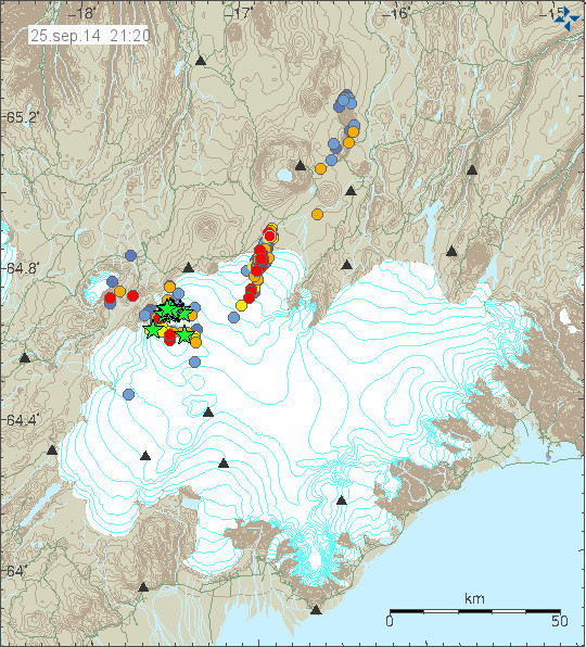
Earthquake activity moving along the dyke towards Bárðarbunga volcano as pressure increases. There is also considerable earthquake activity under the Holuhraun eruption. Copyright of this image belongs to Icelandic Met Office.
If anything major happens I am going to post update soon as I can.
Still waiting to see a green star above the dyke to show up. Jon has your estimate regarding the point of no return in Caldera subsidence still unchanged?
It is now down to 55 – 75 meters. There is a problem in my calculations that I am dealing with. Not sure what is going on. The caldera is going to stay up for as long there is magma inside the magma chamber. Once that leaves, we are going to have caldera collapse.
Jon, Does this mean the chances of getting a huge and possibly lengthy period of glacial water flooding are diminished now in favor of just an outright huge explosion from the caldera? I am worried about that, because a lengthy period of glacial water flooding would provide predictability and convince authorities that there will be large, destructive eruptions in the near future, and get them moving on Plan B (evacuation of Iceland). Naturally, that would be preferable.
Hi me again, I hope you don’t mind me trying to get the dynamics between a glacier (which I do know a thing or two about) and the completely unfamiliar territory of volcanoes? Did you incorporate the dynamics of an ice sheet into your caculations? The eruption in 2010 under the much smaller glacier allready escalated into a lot of trouble, the forces working together now are even bigger.
http://en.wikipedia.org/wiki/Glacier#Isostatic_rebound
The glacier works in two directions, it helps keeping the form and shape of the volcano intact but it also pushes down on the rock with incredible force. This is not just a volcano with a cute little icecap but it is a volcano under a sheet of ice which is as relentless and unforgiving as the volcano itself.
I am from this region: http://en.wikipedia.org/wiki/Hondsrug
Because off a very enthousiastic geology teacher and my own curiousity I got interested in the subject. I don’t know how much you know about glaciers (probably a lot since the biggest European glaciers are in Scandinavia. 😉 )
I wonder what the eruption would have been like without the glacier on top of it.
The “Scenario 3” of the Met office will involve a lot of glacier melting in the process of drawing down the caldera. That’s where it subsides enough to open up a crack to the surface and cause a prolonged interaction between lava and glacier.
I can’t imagine that even the worst case eruption scenario would require evacuation of the entire country of Iceland.
Hello, Liz. In areas of Indonesia, the Philippines, and Pacific Islands, islanders are far more familiar with very large volcanic eruptions, and DO EVACUATE entire island populations or large areas whenever they get wind of a giant eruption looming. This is because of not only lahars and pyroclastic flows, but unpredictable opening of new fissures and very hot toxic material coming out of their eruptions and spreading far and wide unpredictably. Resulting massive ejections of lava and volcanic ash will vary their direction depending on the wind’s direction, thus undoubtedly reaching every corner of its island at some unpredictable point. In Iceland’s Bardarbunga you do have the additional super-mess of glacier ice on top of the caldera having to be broken up by earthquakes, melted by the lava underneath, and moved out of the glacier through massive flooding. Iceland, while not as small as some islands, does not have modern densely populated megacities, which are harder to evacuate. In view of the fact that the pressure of lava under Bardarbunga to explode is still increasing day-by-day, common sense would dictate that to be safe, this would be a good time to start planning on evacuating the Icelander population, particularly if huge floods begin (indicating a certain and imminent eruption of the Super-Volcano). The Plan B to evacuate the population though requires some planning, such as arranging emergency convoys of ships used in transporting troops making round-trips to, say, a Norwegian drop-off location, until all the people of Iceland are onto safer ground. Even individual action, planning a stay with friends or relatives a long way away from Iceland until the eruption allows those people to return to their homes, is wise and Icelanders should be doing it! Hopefully Plan B would not be necessary, but what harm can come from creating a Plan B in the even that it will be needed?
It isn’t that easy to shut down an entire country. I’m not suggesting that worst case planning shouldn’t be done, just that it’s not feasible to evacuate a whole industrial economy, not to mention the rural agricultural communities who would have to leave livestock behind.
Bardardbunga is not a dormant volcano…. it erupted also in 1996 (through the glacier ice, but only for half an hour, but it had even then the power to see daylight….). I.m.h.o. (not being expert however) this volcano is respirating once in a while to release it’s energy, so a caldera collapse or smal outbreak would not at all surprise me. All signs point to activity on all depths below this caldera…. Even an outbreak in the western side would not surprise me. The volcano positions very much on the centre of the rim of the MAR where continents drift apart. The semi-plate (in between the 2 big plates of North Atlantic and Euro-Asian plate) might even “rotate”and “wobble”, which can explain the odd directions of the GPS (rise in some places, going west where u would expect east etc), which go against logic of simple 2 plate tectonics (NA plate goest west, Eur-plate goes east). just my 2 cents. Jon, what do you think about that?
The eruption in 1996 did come from Grímsfjall volcano. That was proved by chemical analyse of the magma.
Bárðarbunga is currently erupting in Holuhraun. The odd movements of GPS shows that magma is doing odd things in the ground. This is normal tectonic movement and it is not going to affect large area outside it. Nature moves things slowly, but it does move.
Ok, Jon, thx. So let’s hope it’s continuing going slow and easy for Iceland then! 😉
In 1996, there was an eruption in Bárdarbunga, yes.
First Gjálp erupted on 2nd October 1996. That is half way between Grimsvotn and Bárdarbunga.
And on 6th November at 1pm, just several hours after the massive glacial flood, Bárdarbunga also erupted, with a ash cloud 4km high, but only for 20min. Where, I do not know, but somewhere within the caldera, or on its edge.
Information to confirm that:
http://earthice.hi.is/gjalp_eruption_vatnajokull_309_1310_1996
Actually the whole sequence in 1996 started out with an 5+ magn. earthquake on Sept. 29 in Bárðarbunga.
http://www.geo.uu.nl/~seismain/pdf/2010_Bardarbunga_EPSL.pdf
The non-double-couple earthquake was also interpreted as indicating a caldera drop.
Though in the end, the chemical analysis proved that the magma originated from Grímsvötn, there were both volcanoes involved.
And it seems what we see now has a longer history.
Yes, the strong earthquake in Bárðarbunga is believed to have started the eruption in Gjálp (unconfirmed). It is also believed that these two volcanos somehow interact with each other and are part of a larger system, belonging to the same set of lineaments, as was or stil is Laki.
Fissure eruption at Holuhraun is pretty spectacular on Mila 2 right now, and it looks like a veritable mountain of lava is building up alongside the eruption, giving the appearance of nascent rim.
Could we be witnessing the formation of a new volcano?
If this keeps going for months, or even years, as Jon suspects it might, I don’t think it is beyond the realms of possibility, and that would be pretty darned cool……
Yes, a shield volcano will probably form at this location. That will have little or no bearing on Bardarbungas activity.
Yes, this is a sort of baby shield volcano.
It has around 0.5-0.6 km3, which is about a tenth of the volume of an average shield volcano in Iceland. If it continues at this rate, within a couple of months, it will be in fact be a good sized shield volcano.
In the region south of Askja, one of the dominant form of volcanism is precisely shield volcanoes. With at least a few of them around, like Trolladyngja or Urdárháls.
From my calculations shield volcano eruptions occur every 1000 years, in the region betweenn Bárdarbunga and Tjornes. Because there are a bit more than 10 Holocene shields in the region, hence one per 1000 years on average.
Though there have been eruptions at shield volcanoes like Þeistareykjabunga or Krafla – if one likes to see the Krafla as such, there was most of the new shield volcanoes have been built up in Iceland at the end of Ice Age (around 9.000 years ago). So no, there have not been new shield volcano formations every 1.000 years in Iceland.
See also the discussion with volcanologist Haraldur Sigurdsson re. shield volcanoes in Iceland: http://vulkan.blog.is/blog/vulkan/entry/1440799/#comments
See also:
M.J.Rossi: Morphology and mechanism of eruption of postglacial shield volcanoes in Iceland.
http://link.springer.com/article/10.1007/BF00304437#page-1
Haraldur Sigurdsson also emphasizes that shield volcanoes do not be connected to volcanic systems (in one of the a.m. comments), but A. Gudmundsson, just states that they are often on the periphery of volcanic systems. And that they would have a deep seated source.
http://www.annualreviews.org/doi/abs/10.1146/annurev.earth.28.1.107
The last would be in accordance with the ongoing eruption in Holuhraun.
On the other hand, to me it seems that the big lava rivers would speak against the building up of a real shield. Also the kind of lava -anyway as shown in the videos – ressembles more AA lava than the typical very flat pahoehoe lava of other shield volcanoes.
It will perhaps depend on the geomorphological confinement of the lava field, and a change in lava composition (which is perhaps taking place just now), if we are looking here at the formation of a shield volcano.
Also the possibility of jökulhlaups has to be taken into consideration. A big one would probably have an important influence on the formation and form of this lava field. It could eg. destroy parts of it.
@IngeB you’ve got me thinking, and Jón forgive me if this leads to more crackpot theories although it probably won’t since it goes against the prevailing ideology generating most of those: if there’s a correlation between the end of the ice age and shield volcano formation, and if (big if) we’re seeing a new shield volcano now, could it be the climate-change melting of the glacier is the cause — could we be seeing a consequence of isostatic rebound at the climate scale?
The operative question re this hypothesis being, how fast is the Vatnajökull glacier melting now relative to the Holocene, now that we’re well into the Anthropocene? I know the vast majority of the world’s glaciers are melting incredibly fast, but elevation/jet stream anomalies etc are also factors.
Ah, answered that one via google: http://onlinelibrary.wiley.com/doi/10.1029/2005JF000388/full
“Modeled ice volume is reduced by half within 100–150 years. About 2030, annual average runoff from the area that is presently covered by ice is projected to have increased by approximately 0.7 m yr−1 for Hofsjökull and by 1.4 m yr−1 for southern Vatnajökull.”
Yes, I’m aware these volcanoes are driven primarily by tectonic forces and the hot spot, but they could still be triggered by other factors. Could ice melt be one?
Oh also, the Hawaiian volcanoes do cause lava rivers, of great length, even if of different composition from what we’ve seen here so far. One scary tropical night I saw one pour into the ocean.
Perhaps the main condition for a lava lake apart from viscosity is existing topography, unfavorable in this case, so far. Can they make their own lakes I wonder, once enough lava hardens around the perimeter?
Your ideas are not strange at all, but have been mentioned by others. As research showed a overall increase in volcanic activity in Iceland directly after the last Ice Age and it is thought that the isostatic rebound could initiated an increase in melt production in the mantle, see eg. http://onlinelibrary.wiley.com/doi/10.1029/2001GC000282/full , but also Icelandic geologists like Magnús Tumi Gudmundsson and Páll Einarsson mentioned this.
Ah, I see it’s everywhere in that article, and the conclusion seems to side with the argument the melting ice had to be a factor, and that there had to be some focusing into channels and fractures for it to work. Wish I had the background to comprehend it more fully!
“[49] Changing the composition of mantle entering the melting region at the time of deglaciation has little effect on melt generation rates, so is unlikely to be the cause of the postglacial burst in volcanism or the geochemical variation.
[50] If the peak in eruptive activity is primarily caused by increased mantle melting rates and mantle melting is accelerated by ice unloading, the temporal relationship between deglaciation and the burst in eruption rates is controlled by melt extraction velocity. Since the burst finished less than 2 kyr after deglaciation, melt extraction velocities of more than 50 m yr−1 are required. Such velocities cannot be produced by simple porous flow and require melt flow to be in channels or fractures in the mantle.”
KMF, you would have to look towards Pine Island, Antarctica at the Thwaites glacier for closest comparison to Bardarbunga.
Thank you! I will look into this. 🙂
Mila cams are looking quite spectacular. Going by what I see it seems the fissure eruption is gushing lava, and if anything has picked up the pace. This is a classic Icelandic rift eruption and it shows by its power and shear volume.
Meanwhile BB seems to be inflating so I can only surmise that this enormous volcanic system is under a lot of pressure from even more fresh magma rising. We’ve not really seen anything in modern times that allows us to judge the historic events for which Iceland is famous, but if anything this eruption is showing us that the Laki event may be more than legend, as if there were any doubt.
There are two extremely large fountains visible on Mila 2,both hundreds of meters high. Keep in mind that Mila 2 is now shooting a quite sizable volcanic massif, not flat ground like when the fissure first opened. If they look large and intense, they’re giant.
Pressure has to be very high.
There is so much smoke and gas that it’s very difficult, without knowing the terrain, to know the height of the fountains, but it seems tonights action is more vigourous. You can see a very powerful fountain on the right, and from time to time, although obscured by gas and smoke another fountain appears on the left. In between these two lava fountains the entire fissure seems to pulse with waves of lava that spill over what appears to be the rim of the fissure. It’s literally gushing out, and the glowing lava lake seems a bit bigger.
I guess we’ll have to wait for the, no doubt very fatigued, Iceland geologists to tell us what they have measured. If the bright orange glow is mostly lava fountains then these are indeed Etna, or Hawaii style monster fountains. My only concern is the resolution of the cameras makes it difficult to judge – well at least for me 🙂
Average size of fountains is 40-80 meters.
I think the highest reported was 150 meters high.
It´s pretty high, but Laki was taller, and Hekla can also be taller.
I am delighted to find this map that provides specific information to location of seismic data as in location of ALL tremor stations
http://gps.vedur.is/mapSIL.php
The reason I found it is that I noticed that sizable drop during the 5.5 earthquake on September 20th at noon resonated with about 50% of the 60+ tremor graphs. I noticed the same graphs resesonated with a couple other events. I mostly focused on the red and green. Someone taught that they have to do with magma build up. After the drop of the caldera on September 20th the red signifantly went down. South East stations as a group were all effected. North West stations as a group were not.
For instance the effected stations were:
alf, asb, asm, bja, esk, fed, god, grf, grv, hua, hei, hus, hve, hud, Jon, kas, kri, kud, mid, mjo, nyl, rju, rne, san, sly, skr, snb, Sol, vst, vme, vog, con, vos.
sau is also in the area yet seems broken.
smj sort of fits with the group.
hus & vst works with the criteria yet I was not able to find them.
What interests me is that many of these are building up as indicated by looking at the red.
It’s is often better to use the Icelandic tremor site (órói). The links work better there.
http://hraun.vedur.is/ja/oroi/index.html
You’ll find hus (Húsbondi) a bit to the southwest of Grímsvötn in southern Vatnajökull, whereas vst is a bit to the northeast of Kverkfjöll area on the northeastern margin of Vatnajökull.
Anyone know why the Mila webcam sites etc. try and set up to
15 COOKIES?
SHEESH! I block them and have things set to be notified of such intrusions. Which, of course, means that I have to “OK” each notification. But I’d rather put up with all that than the cookies . . . as a matter of principle and policy.
Jon, I’ve subscribed . . . is there any other “registering” action to be done? I still have to bother with the CAPTCHA screen for every post. Sigh.
Thanks for all you do. I hope you’ve gotten the new router covered with donations.
Hi Da Xin – Subscribing is not the same as registering. You have to register in the Meta section. It is on the right side, close to the bottom, between a couple of Amazon advertisements. Once you register, Jon will approve later today.
As for Mila cams, they are free and I appreciate they have set them up for us to witness this spectacular event, so I, for one, do not mind their cookies.
THX THX MUCH.
Will track down the register button, then.
In terms of Mila’s webcams . . . CERTAINLY I greatly appreciate their providing them . . . and for free.
Nevertheless, imho, 15 cookies is far too many. Very intrusive, Absurd . . . and worse.
Consider Ghostery. Less intrusive blocking. Who knows what the hidden price of using *it* is though.
Bit offtopic > in the USA > Mammoth Lakes > also Vulcanic Activity? many quakes around 3.0 > http://earthquake.usgs.gov/earthquakes/map/
Don’t want to pull Jon’s blog Off topic, but noticed this activity myself. 340 quakes near Mammoth airport in less than 24 hours. Swarms are not unusual here and while they remain at 6km below the surface they are not a threat. If ground swelling is noted or the depth gets less and they quakes creep towards the surface then I wouldn’t want to be at the airport.
Thx now back to Iceland *off Topic Close* 🙂
This is on the edge of the Long Valley Caldera. There has been holocene activity in that region. There is some CO2 venting that has killed trees and some areas are off limits to camping due to high CO2 that can potentially suffocate someone in a tent. It is an active volcanic region though there has not been any activity recently. Last significant activity was apparently just before settlement of the area. This area has become less active as the last of the Farallon plate subducted but there is a spreading center that has subducted under the North American plate that runs from between Baja California and the Mexican mainland, up through the Salton Sea area on northward.
There has been some building over the centuries of a resurgent dome in the caldera and some peripheral activity from other magma sources (e.g. Inyo Craters). The magma from these events is very high in silicon content, if I recall, tending toward explosive events, somewhat like the Cascades activity.
Seismicity monitoring re. Long Valley Caldera
http://volcanoes.usgs.gov/volcanoes/long_valley/long_valley_monitoring_1.html
Information on the geology of the Long Valley Caldera (USGS)
http://volcanoes.usgs.gov/volcanoes/long_valley/long_valley_geo_hist_13.html
Good map here
http://www.data.scec.org/recenteqs/Maps/119-38.html
A *lot* of microquakes
Looks like the show us over for the night. Weather is closing in. That was spectacular viewing. I really hope some wonderful person has recorded a timelapse video.
I’m using a tablet so can only watch. And the alarm has just gone off, time to get up. Got a gig to go to tonight; the astonishingly wonderful Kate Bush.
I know too little to work out an idea with reference to the subsidence of the caldera. Am probably also too ashamed to show my ignorance to professionals and experts on such a list as this. So I shall go on learning and watching, thank you all for that, but unless something rips open because of sheer stress before then, I predict that the caldera will stop subsiding at about 30 – 35 m, after which Bardarbunga will take another well-deserved rest until the next time it is bothered. We’ll see what we’ll see. And please don’t blast me for this. I simply must say it somewhere. 🙂 No fear, this thought is not based on any religious, prophetic, magic, or any such reason, nor has it come to me in a dream. It is very practical, but probably immensely stupid, so it will simply be interesting to see whether it pans out and fits into the scientific picture in the end… or not.
hen
One of IMO’s three scenarios is that the eruption and subsidence stops, so it may happen.
Given BB has subsided before without full eruption, that does have to remain the null hypothesis, IMO as well, despite the violence of the earthquakes suggesting strongly otherwise.
It seems, that the 4,1EQ (03:42 UTC) caused noticeable glcier drop
… or the drop caused eq 4,1 – who knows 🙂 (eq’s depth is only 0,1km )
The eq’s in the caldera are occuring at the contact between the volcanic plug and the sides of the conduit in which the plug solidified.
These eq’s cover the full depth range of the plug right upto just below the ice (the quake you mention).
Well that’s the way I see it. Am I correct about this?
I am not sure, where the M 4,1 was located. Maybe the accuracy in depth is not so high as we think.
I agree with crosspatch (10:01) about the measurement inaccuracy.
Is it possible to see how the Volcanoes beneath Vatnafjökull looks like if the icecap was liftet of? Would the area not change a lot if the pressure and the cold from the ice dissapearet – making it alter?
I read on a map that the glacier IS retreating – but not how much and how fast this is happening – is there any data on this?
Finally – I definately dont think an evacuation of Iceland will be nessaceary – but I am aware that a big eruption might take place and might do some local enviromental and infrastructual damage – and if the winds and the other forces of nature makes it so, it also might influence aviation for some time and make the temperature drop a bit for some years.
Re glacier retreat I posted a link to a paper from 2004 above (in reply to IngeB) about model runs that suggest yes indeed, the glacier is melting and will be melting faster and faster.
stars1die – not quite time lapse but if you press ‘keyra’ the stills from the day are played in sequence (manually change the date in the address bar for different dayshttp://brunnur.vedur.is/myndir/webcam/2014/09/26/webcam_mogt_kverkfjoll.html#
Apologies, missing a few gaps, for clarity
http://brunnur.vedur.is/myndir/webcam/2014/09/26/webcam_mogt_kverkfjoll.html#
Thanks a lot for that link !
I’d forgotten about that link. So used to only having the Mila point of view 🙂 thanks for reminding me!
Along the edges of the caldera is also where resurgent activity takes place. An example being the quake swarm mentioned in an earlier comment at Mammoth Lakes. That is also on the edge of the Long Valley Caldera. If you look at this map you will see that the quakes are also on the edge of the (rather huge) caldera. That is pretty much normal.
Normally this time of year we see ablation of the glacier due to melting. As this GPS station was not positioned here before the current eruptive activity, we do not know what the normal daily ablation rate was of that glacier. We are also getting more quake activity which will act to settle the ice. As we get more into the colder season we should start seeing less melting. The nights are growing longer and colder.
I am expecting to see a reduction in the steady state drop between earthquakes and a general reduction in the amount of drop following quakes as the ice becomes more compact. In fact, we are already seeing that. We have seen two consecutive M5+ events that resulted in no drop at all. We did see some drop after an M4 event very close to the surface of the crust in the caldera.
If the drop in the glacier is only caused by settling and / or melting and not a physical drop in the caldera (as already proven by ground penetrating radar) then why is the drop only in the caldera and not the general area of the caldera? Why are there cracks in the ice only around the caldera? Why is there a giant bowl over the caldera?
Fly overs and mapping of the glacier are carried out frequently and no bowl was observed prior to the start of EQ activity.
I believe the settling being erratic can be explained by the thickness of the ice. If the caldera is dropping at a slow and continual pace, the ice will not immediately follow as it takes a long time for 1/2 a mile of ice to reform its shape. A hollow or “bridge” will form between the ice & the caldera. When a large quake strikes that causes the glacier to settle until it reaches the new position of the caldera lid. That would explain why not every quake causes settling, it’s really down to how much of a gap had formed, if any at all.
Although I respect your knowledge and opinion, AND I likewise believed in your theories concerning the glacier and ice settlement… a recent post supplied evidence of the caldera subsidence. So, I’m a convert of sorts to that line of thinking. On the other hand… the conclusions drawn from the caldera subsidence are varied, and don’t necessarily convince me of an imminent caldera roof collapse. If it works… here’s the link:
http://jardvis.hi.is/sig_bardarbungu_maelingaflug_13_september_2014
While it’s in Icelandic… the data [supposedly based upon ground penetrating radar] is rather convincing.
[link orig. provided by @Kolla September 25, 2014 at 21:30]
More data needed. The latest 5.2 (subsequent to your comment) caused a typical drop.
Sorry, the map is here I think, unless I keep screwing up the link.
Ok, I am somehow messing up the anchor tag.
I will try to post the link bare
http://earthquake.usgs.gov/earthquakes/map/#%7B%22feed%22%3A%221day_m25%22%2C%22search%22%3Anull%2C%22sort%22%3A%22newest%22%2C%22basemap%22%3A%22street%22%2C%22autoUpdate%22%3Atrue%2C%22restrictListToMap%22%3Atrue%2C%22timeZone%22%3A%22local%22%2C%22mapposition%22%3A%5B%5B37.43343148473673%2C-118.98056030273439%5D%2C%5B37.84232584933158%2C-118.35708618164064%5D%5D%2C%22overlays%22%3A%7B%22plates%22%3Atrue%7D%2C%22viewModes%22%3A%7B%22map%22%3Atrue%2C%22list%22%3Afalse%2C%22settings%22%3Afalse%2C%22help%22%3Afalse%7D%7D
Why are we going off topic? Please stick to Iceland. Thanks.
There used to be quite a bit of discussion of El Hierro on this blog, and I believe Jón was even considering moving there. I think we do make some exception for earthquake swarms.
Any More Guestimates on probabilities of glacial flood within next month within next year how about a range 20 to 40 pct one month 30 to 60 pct one yr OR ??? Jon ? Others?
With continuing eruption the pobability of glacial flood increases from month to month, it is therefore an underestimate to assume that the occurence in any particular month is independent accross different months.
Once you accept independence the probability p for the entire year is given by
p=1-(1-q)^12,
where q is the probability of occurence within the month.
For q=0.2 that would be 93% and is predicated onthe eruption continuing for the entire year.
please see my reply which got posted on down (sorry it is out of place) thanks for you idea.
As Jón says in his post, given the quakes in the dike are increasing to the south, indicating a rise in pressure in the dike, there could be a subglacial eruption any minute and a flood shortly after that.
Does anyone know if there is a chart showing the vertical displacement since the event began? All that I can see is one showing data from 12th Sept. to date.
There was no monitoring equipment in place until then. They flew up to the Caldera and placed a GPS unit on top so they could monitor the displacement accurately, rather than rely on visual observations.
Thanks.
There is no chart (because the GPS was placed there only on the 12th), but the total subsidence was measured at 23m on the 14th of September. You can fit that into the chart and see that the total subsidence would now be somewhere around 28,5 m.
Does anybody know what´s happening at Grímsfjall?
http://hraun.vedur.is/ja/oroi/grf.gif
Weather
Agreed. Stormy weather = unreliable readings caused by noise & vibration.
Doesn´t look very windy to me.
http://www.vedur.is/vedur/spar/stadaspar/midhalendid/
Big storm in the North Sea today
indeed: http://www.meteoalarm.eu/
They are warning about that.
According to IMO, about an hour ago there was a 2.6 quake at literally 0.0 km depth. Is that even possible? Or is this the ice cracking on the surface under the strain?
I asked the same question the other day, there was a whole load of 0.0 and o.1 km quakes just NW of BB but as of now no one came back with an answer. If you look on 3DBuldge you can see these strange depths showing up quite regular. Is it ice or something else.
This are surface earthquakes. This are not glacier quakes.
In my non-scientific opinion… Bárðarbunga has entered a new pre-eruptive phase, with an eruption probable in the next 72 hours. That would be Monday, September 29th. That’s based upon the shallowness and intensity of recent EQs.
[Perhaps IMO should go ahead and raise the aviation alert to Red as a precaution.]
Isnt it most likely that IF it erupts – it will do it at the slope almostly borderting the Vatnafjökullgletcher – where there is less ice to penetrate/melt?
Shallow and intense EQ´s predict eruptions – Is that what you say? If so can you explain it a bit more, please 🙂 Thanks a lot 🙂
My comments are non-scientific, and opinion only. I’m a novice observer only — with no formal education in this field.
I believe the internal pressure within the magma chamber [and the greater Bárðarbunga rift system] is generally upward and outward (i.e. greater than the downward pressure of the overlying rock and ice).
The shallowness of the EQs combined with their intensity and general location are suggestive that the magma is approaching the interface between the caldera surface and the glacier.
There was recently a magnitude 4.1 EQ @ only 100m located 3.7 km NE of Bárðarbunga. This is the approximate center of all the EQ activity around Bárðarbunga. Is it meaningful? Perhaps.
Perhaps IMO should listen to scientific opinions rather than non-scientific 🙂
I believe thats what they do 😀
Mass sudden increases of activity at Long Valley is often put down to a faulty sensor. Check back in a few hours so that the USGS guys can review these.
While your O.T. Sinabung is slowly starting to kick up to life again.
This should be in reply to Torsten’s comment of 07:53.
I don’t know how it posted at the bottom of the thread
Try registering and then signing on via the link under the meta tag on the right. The theory is if a comment fails captcha, it fails to append to the intended thread. You may need Jón’s help to register — I don’t remember myself, it was so long ago.
I wish that I understood Icelandic, great video from Sept 25th here, shows what is believed to be the interaction between magma chamber, caldera, EQs, and dike, and how an eruption might occur on the edge of the caldera: https://www.youtube.com/watch?v=qJhJtD4A9h0#t=1062 stay with the video past 18:25, brief interruption before returning to the model at 18:45.
Here is another video with same content from RUV with subtitles.
http://www.ruv.is/frett/what-is-going-on-at-bardarbunga-video
That video seems to indicate the presence of a couple of subglacial lakes in the caldera. Any truth to that?
Please keep on topic. There is plenty going on in Bárðarbunga at the moment. There is also storm going over Iceland at the moment creating a lot wind noise for a short period of times. Several storms are expected this weekend in Iceland.
Some more small quakes in the caldera now. Wonder what this means.
I am trying to better appreciate location of the various EQs around Bardar, looking at the Sept 26 frame here: http://hraun.vedur.is/ja/Bardarb/bbbeginman24h/images.html# we see the largest EQ today (the 4.1 from 03:42 seems logical according to http://en.vedur.is/earthquakes-and-volcanism/earthquakes#view=table). The first link shows the location of the EQ straight north, on the northern edge of the Caldera, though the table shows this 3.7km northeast. Also, when you plot the Lat Long on Google Maps it also shows the 4.1 EQ to the northeast https://www.google.com/maps/place/64%C2%B039'57.6%22N+17%C2%B028'40.8%22W/@64.666,-17.478,11z/data=!4m2!3m1!1s0x0:0x0. With the Caldera about 7km across, 3.7km does put the EQ on the caldera edge, just seems to me that it should be northeast edge and not north edge.
Dear Jon: Thanks a lot again for all your efforts and your work keeping us updatet and answering our questions 🙂
I have a hypothetical question (for my deeper understanding of volcanoes):
Could the calderalplug actually drop like this one does – if the icecap were not there? Would there be fumes to see – cracks – or in other words – how would it look?
I read somewhere that the plug is now like dough – but still doesnt melt in the magma below – due to its present conditions (pressure, heat etc) – but I asume it WILL melt eventually, if it actually drops down into the magmachamber. Is that correct?
Yes, the caldera would drop like this even if there was no glacier on top of it. I don’t know if the crust in the caldera is going to melt, but it might be getting soft due to all the heat.
Thanks Jon.
How great do you estimate the risk of an actual caldera-collaps?
new eq M5+ ?
I was just looking at the caldera GPS and wondering if there’d be an EQ. IMO has it at M5.2.
If this one shows 4.9, it could be over 5, i think
http://geofon.gfz-potsdam.de/eqinfo/list.php
5.2 at 4,4 km depth according to IMO
Yes, it was already there 🙂
USGS has it at 4.9 at a depth of 6.8 km.
http://earthquake.usgs.gov/earthquakes/
IMO marks it as another 5.2 in the NE side:
Friday
26.09.2014 16:49:28 64.670 -17.447 4.4 km 5.2 99.0 5.1 km NE of Bárðarbunga
It’s been mentioned before that USGS are not accurate for Iceland. The clues are in the names United States GS – Iceland MO. Who do you think has the most equipment in Iceland and is giving the most accurate readings?
It was sometimes mentioned that the system is going to be unstable due to the seismic actions there. But as a layman I am pretty astonished about the very stable form of caldera collapse. You can say that every there will be at least one M5+ earthquake and the crust falls around 50cm (mainly one drop). How can this fall be so steadily when we assume there must be an unstability of the system?
The system does seem to be unstable and it is in a current pattern of gradual progressive subsistence punctuated by period drops in response to large EQs. Do not expect every unstable system to behave like this – or for this kind of pattern to necessarily continue. At a certain point I suspect enough might be enough and there may be a sudden collapse. It is also possible activity may decline. It is clear; however, that long-term the system is destabilized and eventually there will be a collapse.
I´ve been thinking the same. How come there aren´t more variations. The 5+ quakes have become almost daily regulars and the drop curve is amazingly even. A state of stable instability.
Yes, predictable, cycling subsidence, big drops accompanying most but not all larger earthquakes, occasional uplift but not enough to stop the overall subsidence. At some point something will give or things will quiet down and stabilize. The best predictor might be to look at things the way the are now and project out. I don’t believe that the current subsidence can continue without some failure/eruption.
And since I asked about this a couple of days ago, we can add to the stable pattern folks like us noticing and asking about it. 🙂
Agree, the subsidence is pretty linear, however it seems to be a little more erratic in the last 48 hrs, also there is an increase in m5+ quakes , the recent one is the first to register a drop in the gps since the 5.2 on the 24th.
I keep looking at the rate of subsidence and it seems it is slowing, only to let go soon after!!
(i recently predicted 24-36 hrs between m5 quakes as this seemed to be the case for around 10 days…..so wrong!! never try to predict a volcano 😉
If this is “caldera collapse” it is in a most unconventional form. Caldera collapse is generally the end stage of a massive eruption where a large magma chamber has very suddenly emptied and can no longer support the weight of the mountain above it and collapses into that empty chamber.
In this case we have had no such eruption. We have a relatively (for this particular system) small fissure eruption. Analysis of the magma shows it is deeply connected to the mantle. So this is not evolved mamga that has been sitting for a long time cooling in a magma chamber.
GPS would indicate the area of the main volcano is inflating, not deflating. The best two explanations I can come up with that would account for the behavior is A: a rifting of the caldera itself causing it to widen which then allows the center to drop and B: there is an eruption ongoing under the ice in the caldera that is not yet visible on the surface due to the huge amount of accumulated water and ice. The heat from this would be melting ice from below and the water has not yet found a path out of the deep caldera so we don’t see evidence of any flood, either. An eruption outside the caldera under the glacier would cause a readily visible glacial flood, an eruption inside the caldera would possibly result in that water being contained by the caldera itself until it rises to a level where it can spill out somewhere.
Water under some 700 meters of ice is not going to flash to steam on contact with magma. There would be enough pressure to keep it liquid. It would likely rapidly convect upward and cool on contact with ice. I would expect a rather turbulent convection zone in the area of that eruption. Any steam that might try to escape would be quickly condensed back to water by the ice. The only way we would see any steam would be for a crack to form from the surface to great depth and that might be practically impossible. The only indication we would see on the surface would be the level of the ice drop. Glacial ice contains a lot of trapped air and volume reduces when melted.
We have all indications of magma being injected into the system. This is not a situation that would be conducive to conventional “caldera collapse”. Note that I am not a geologist, I am an engineer. I am applying basic principles of physics here to try to make sense of what we see. What I have said is speculation, but so is pretty much everything that has been said in trying to explain this, even among the most learned volcanologists. We just can’t see what is going on at the bottom of 700 meters of ice/water.
Some interesting things to note: Note how frequently we see a rise in the ice before we see a drop. Note how sometimes the drop in the ice comes a considerable time after a quake. Sometimes there is a drop without a quake, sometimes there is a quake without a drop, But in nearly every case, we see a significant rise in the 30 minute average immediately before a drop. I don’t mean to say that this rise immediately before the drop “means” anything in particular, I am mentioning it only to draw attention to it and to make note of it as I find it a curious thing.
Thanks Crosspatch for your insightful comment.
I’m concerned about climate effects of this eruption but so far have no clear idea of the amounts of SO2 already released and the rate at which they continue to be emitted now.
It looks like the amount of lava is quite large, more than 0.5 km3, but how does this translates into VEI or amount of SO2 and aerosols in comparison with a known large eruption, e.g. Pinatubo?
I thought perhaps Jon could give a rough estimation based on his experience/gut feel of what the prob. might be for say the next month. then again for the next year.
the monthly probabilities would not be expected to be independent by me (although your point might be approx. applicable)
I am just a math/stat type with new hobby, vs. any geological experience/knowledge of models/or rough idea based on any relevant experience. that 20% I started with is just out of the air. maybe it would go up conditionally if no event in next month, for following month. from one pt. of view. maybe it will go down substantially if activity slows down in next month. Not a simple model or equation to pinpoint or quantify, more complicated!
I believe that there are too many factors, and the earth is too complex for us to predict with much confidence. We might see some sudden increase in EQs, subsidence or movement that will signal something more likely as a warning, or the whole thing could fail suddenly.
I meant for this to be reply to: absalom hicks says:
September 26, 2014 at 18:19
Not easy to predict since this is the first time there has been so much monitoring and real-time data avaiable for a caldera collapse. I would imagine not all caldera collapses would proceed in the same way. Watching an historic event with respect to the knowledge that will be gained in volcanology.
Hi Jón, could you explain to us the change in 1Hz tremor in Kreppuhraun? Is it something going on or is it just wind?
http://hraun.vedur.is/ja/vatnajokulsvoktun/kre_trem.gif
http://hraun.vedur.is/ja/oroi/kre.gif
Jon already mentioned the storms earlier. They are affecting readings & are expected all weekend.
Looking at Bardabunga webcam 1, I asked me, if there is more steam at the right side because there is more water interacting with lava or is it because the falling temperatures?
Jon, pressure in the dyke north of the fissure continues to get lower and lower as measured by eq activity.
Why will the caldera collapse as the last of the magma leaves? it is already collapsing and the fissure is a pressure relief valve. The end game is just going to be the settlement ending prior to reinflation at some point in the future.
What say you please?
Chemical analysis of the magma suggests it comes from a deep source, not from a relatively shallow magma chamber and that it is relatively fresh magma, not magma that has sat for a few hundred years in a relatively shallow magma chamber. The magma that is currently erupting appears to be “fresh” magma recently injected into the system, from what I have read so far.
As is explained in this rather good, if popularised, BBC special, hot new magma has remelted and pushed out older magma on occasion. This may or may not have happened here, but would account for the different chemical composition found in the lava over time.
https://www.youtube.com/watch?v=blDXgde1Tpg
I have spent almost two weeks chasing up claims there are different lava analysis results to the ones that show the magma comes from a source in the upper part of the crust. If these supposed results exist where are they?
It doesn’t come from shallow magma chamber. It comes from deep source and is primitive basalt. As is stated here on University of Iceland website.
http://earthice.hi.is/bardarbunga_2014#19.09.2014
Jon, thanks for the reply. Haraldur told me personally he only knows of the analysis he has blogged about showing the magma comes from high in the crust and has not seen the data modelling mentioned in the 19th scientific board report. Haraldur continues to talk publicly that the magma comes from high in the Earths crust (the crust being around 40km thick)
There is no publically available alternative analysis anywhere to be found.
Jon, So we can be clear what i am talking about, the IMO statement of the 19th only mentions the magma source is greater than 10km. which fits with the idea of the magma coming from high in the earths crust where the crust is thought to be 40km thick in this area.
I have spent so much time on this topic that it might be best for me to fly to Iceland and interview the leading figures involved and encourage them to produce a public statement on this matter.
It is however crystal clear to me that other sources are happy with the idea of a deeper chamber rather than a more direct mantle source for the magma and i have no information on other sources at all.
This area is not so simple. While the crust is up to 40 km thick in this area due to the hotspot. We don’t know there the main magma chamber of Bárðarbunga volcano is, or how deep it is. Shallower magma chamber are now clearly empty, in the sense they are now just being fed magma from deep source at the moment. It is just running trough them.
They know this is deep source magma that has not had any or little contact with the crust since it is lacking crystals, isotopes and other element that are abundant in the crust, but are in less amount in the upper mantle or in the deep mantle. Bárðarbunga is also on top of the hotspot. It’s even closer to it than Grímsfjall volcano.
Study on the matter from older lava flows in Bárðarbunga volcano.
http://www.sciencedirect.com/science/article/pii/S0009254108002623
Jon, I am really struggling here. Are you saying that Haraldur is not a good source of up to date information or he is lying to me?
Providing me with a scientific reference for how somebody like Haraldur can know something about the Magma is not helping me to know why you do not agree with him or why you think i can safely ignore what he says.
Lest there be no confusion at what i am getting at, there is a difference between
1. talking about a deeper chamber at say 11km which is greater than 10km and
2. Talking about the magma coming more directly from the mantle
1. is the area of imo 19th of september and Haraldur. 2. Is unsupported by any publically available information
I don’t think he understands what is going on. As for my personal view is that I don’t trust him any more. At least he blocks my comments when I try to comment on his blog. I don’t know what that is all about, it has however shaped my view.
There doesn’t seems to be any study on deep magma chambers in Bárðarbunga volcano. At least none that I was able to find with Google.
What I did find where studies on primitive basalt that have erupted before in the same area, or nearby areas. They are believed to come from the hot spot it self, rather than the mantle or shallow magma chambers where they have evolved.
http://www.sciencedirect.com/science/article/pii/0012821X80900552 (Density variation amongst mid-ocean ridge basalts: Implications for magma mixing and the scarcity of primitive lavas)
http://petrology.oxfordjournals.org/content/43/2/345.short (Kistufell: Primitive Melt from the Iceland Mantle Plume)
http://www.raunvis.hi.is/~ingib/bjarnason_jokull2008.pdf (Iceland hotspot saga)
Jon, You are probably aware that IMO are not listing an eruption in the caldera as a highly likely scenario unless there is quite significantly rapid subsidence of the caldera. I really want to get to the bottom why people are saying the magma comes from the mantle. Can you recommend a person at IMO that i can get in contact with for a different point of view than that of Haraldur?
Thanks
Andrew
I know that they are not listing it as likely outcome. The problem that they are wrong about it. This is just a question of time and pressure inside the magma system of Bárðarbunga.
They know this since the magma is missing isotopes it if had spent some time evolving in the upper crust or inside a magma chamber.
Information.
http://earthice.hi.is/chemical_composition_basalt_erupted_29_august_2014_through_1797ad_holuhraun_linear_vent_system_north
http://earthice.hi.is/petrology_holuhraun_lava_gudmundur_heidar_gudfinnsson_and_sigurdur_jakobsson
Study:
http://www.sciencedirect.com/science/article/pii/S0016703709001343
I also found this tweet. But he doesn’t give any link to his information.
https://twitter.com/gislio/status/509830054021718018
There is also two or more magma chambers in Bárðarbunga. One of them is at shallow depth, above 5 km. The other is on more depth than 10 km. It is stated here.
http://www.ruv.is/frett/the-eruption-might-last-for-a-long-time
Jon, I feel like we are going around in circles.
Earlier you said: “It comes from deep source and is primitive basalt. As is stated here on University of Iceland website.
http://earthice.hi.is/bardarbunga_2014#19.09.2014”
Whereas the scientific boards report of that day which you are referring to makes no mention of primitive magma when they said:
” Chemical analysis and modelling, of the magma coming up in the Holuhraun eruption, indicates that the magma is coming up from a depth of more than 10 km.”
Subsequently you have suggested to me the IMO does not understand the situation as well as you do.
I feel obliged to ask you if you know of any credible source that agrees with you the magma is primitive? All I would like is one credible source so i can investigate the situation for myself.
For the record, old academic studies are not going to help me understand your position that the scientific board agrees with you when it appears fairly clear that in public anyway they do not.
I have spent weeks on this topic. I would like to get to the bottom of this situation.
Thanks
Andrew
This is also stated here on Icelandic Met Office website.
http://en.vedur.is/media/jar/Factsheet_Bardarbunga_20140919.pdf
Jon, it only says the magma comes from greater than 10km? If it does only say that then that magma could have been there for many many years and have become evolved.
You seem to have stuck your neck out, so to speak, by saying the source of the magma is more directly from the mantle. Also on the internet many many other people are saying the source is from the mantle. I am just hoping to find a reference or some science to justify that statement.
As i said earlier we appear to be going around in circles.
Cheers
Andrew
This was in the Icelandic news few days ago (Ármann Höskuldsson sad so in Rúv News interview). The problem is that new chemical analyse have not been released regarding the change in chemistry in the magma.
Current idea about Bárðarbunga volcano is that there is a two magma chambers below it. One at the depth of around 5 – 10 km depth, that one is now collapsing. The other one might be at 20 km depth, but it has not been proven so far due to lack of earthquakes. There are some seismic wave clues to this, but nothing more so far.
As for the data your are looking for. You might have to wait good 10 years until proper studies are done on what is happening now.
Hi Jon, I was hoping to get back to you before now about Ármann Höskuldsson comments in the Rúv News interview but I got a bit distracted setting up a volcano livestream. I appreciated your answers and the time you took replying to me. Thanks!
Also of interest to me is the increasing number of quakes in the main caldera at a depth of 1km or less.
Looking at the 180 minute graph on http://hraun.vedur.is/ja/Bardarb/BARC/ apart from a very slight slowdown in subsidence I think I also see an increase in bumpiness in the past week or so — a higher fractal dimension at that scale. You just don’t see the long relatively smooth patches of the 13th or the 16th, for instance. And the bumpiness seems stronger in the last day.
Maybe nothing. It’s way too easy to overread these graphs.
The eruption has already started under the ice, only time before we get the big bang
There is no tremor measurement that shows signs of an eruption, from what I have learned from reading here some of these should look different if there really was an eruption going on. http://hraun.vedur.is/ja/oroi/allarsort.html
What I do find worrying is the steep drop and the bigger earthquakes on the caldera drop tab: http://baering.github.io/
How do you know that?
Maybe one of the local trolls told him 🙂
Iceland, where the trolls have trolls.
From Jon: http://icelandgeology.net/?p=1319
http://icelandgeology.net/?p=3291
@Wial very funny.
What we CAN say with some certainty is that there is no eruption under the ice *outside* of the caldera. There would be ample evidence if that were the case, mainly in the form of massive runoff of water.
From what (little) I’ve read runoff from subglacial eruptions can be either delayed or so dispersed as to be unnoticeable, although of course it can also cause absolutely massive floods greater than the largest rivers in the world, as they have done in Iceland in the recent past. Formation of cauldrons, earthquakes, tremor, conductivity in the water and other indicators serve in the absence of that — so don’t base the reasoning as to whether a subglacial eruption has occurred on the presence or absence of increased flow.
I am not sure we know that with *certainty* but there is a good chance of intermittent eruptions in there. We do see bursts of tremor and tremor *is* higher than it was before the start of this event. The trouble is that the ongoing current eruption can mask smaller eruptions elsewhere unless they get pretty large.
There have been small eruptions under the glacier in past weeks. None of them have breached the surface of the glacier.
The tremor pulses are interesting, but do not appear to take place due to eruption under the glacier. The reason for them is less clear, but they do happen due to magma activity.
New article is up about Bárðarbunga volcano.