
This information is going to get outdated quickly.
- Eruption in Holuhraun continues and there are no signs about it ending any time soon.
- Lava lake has formed in one of the south crater according to the news today. The crater is not erupting at the moment.
- Earthquake activity continues along the dyke south of the Holuhraun eruption.
- Bárðarbunga continues to drop and I am estimating that the drop today is around 1 meter a day. This number has not been confirmed. Last confirmed number on the drop was that the Bárðarbunga volcano was dropping 90cm/day.
- The area around the eruption site is toxic. Due to ever changing wind in the area the risk of getting SO2, CO, CO2 and other toxic gases over one self is always present.
- There are warning in place for the SO2 pollution in Iceland at the moment. The warnings are issued based on wind direction at any given time.
- The lava continues to flow into Jökulsá á Fjöllum glacier river. This lava is going to create a dam in next few days. The lava is flowing into the river at such force it doesn’t stop and doesn’t cool down properly to stop the flow of new lava into the glacier river.
- I have been seeing harmonic tremor spikes all day today. I have traced them to Bárðarbunga volcano. I am not sure on location. It is difficult to know for sure what this means at the moment.
Earthquake activity
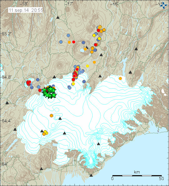
Earthquake activity today. Notice how the green stars (earthquake above magnitude 3,0) form a circle around the caldera that is about to collapse into it self. Copyright of this image belongs to Icelandic Met Office.
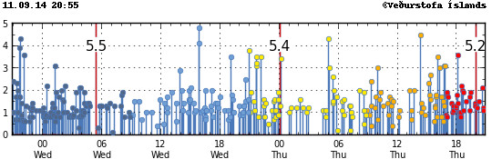
The earthquake trace of the earthquakes today. The larger earthquakes are spaced around 12 hours apart. I don’t know why that is. Copyright of this image belongs to Icelandic Met Office.
Tungnafellsjökull volcano
There has been earthquake activity today in Tungafellsjökull volcano. I don’t know what this means since I don’t have any history about eruptions in that volcano. None have been document in the past 1000 years, and none have shown up in the data for the past 8000 years at least. What I do know is that I suspect the volcano might have started to prepare for an volcano eruption in the future. At least Tungafellsjökull volcano was showing slightly higher activity in past few months than normal, but that earthquake activity did stop and everything did go back to normal until now. This might be as simple as just stress adjustment in the crust in the area. At current time I don’t think an eruption is imminent in Tungafellsjökull, but with no history to work with this volcano might surprise me and everyone else. For the moment I think it is just earthquake activity until I am disproved by the volcano or this earthquake activity just stops.
The caldera formation in Bárðarbunga volcano
The new caldera that is now forming in Bárðarbunga volcano is a large event, since Bárðarbunga volcano is a large volcano. GPS data (website here) says that here is still inflation ongoing in Bárðarbunga volcano and at the moment mostly in the dyke. What is so dangerous with this are many factors. Here is the top list of them.
- The drop in certain parts of Bárðarbunga volcano down its slopes is up to 1800 meters.
- The glacier over parts of Bárðarbunga volcano are up to 850 meters thick in the caldera. Outside the caldera the glacier is up to 600 meters thick.
- There are hydro-power dams south-west of the Bárðarbunga volcano. Glacier flood might go that way. There are also some populated areas that might be at risk depending what way the glacier flood would go.
- Populations at north of Jökulsá á Fjöllum glacier river (downstream) are at risk from large glacier flood. So are two bridges, the third one that is up on the high lands is not going to be saved.
- There is going to be a huge ash cloud once Bárðarbunga volcano collapses into a new caldera. What damage that ash cloud is going to do depends on wind direction. If we have really bad luck we might be looking at air space closure for week or two in Europe depending on wind and weather systems.
- There are other risks that I don’t about yet.
Bárðarbunga volcano caldera (the current one) is around 70 square km in size, around 10 km wide. With the depth of 850 meters and it is full of glacier as I have mentioned many times before. When this is going to hit disaster mode part of that glacier is going to melt and create massive floods. Even if the caldera collapse might happen there is still a high risk of continued eruption activity after that event. Since this might just be a start of long eruption cycle in Bárðarbunga volcano. Since it had been quiet for a long time until 16-August-2014 when this eruption cycle started in Bárðarbunga volcano. What is happening in Bárðarbunga volcano and is creating of a new caldera. The caldera is just now in its early formation stage, when the later stages start to happen I do not know since I don’t have any past data to work with. This does not happen often in Iceland I think and has never happened before since recording of earthquakes started in Iceland.
Updates
If anything major happens I am going to post updates here.
News bits
Subsidence by hundred of meters possible (Rúv.is)
The media in Iceland is now less occupied with this eruption than before. So it is harder for me to get information that way at current time.
I posted earlier about the tremor plot at SMJ which is close to our 2010 friend Eyjafjallajökull.
Would a rifting even tear through the whole of iceland, as its pulling apart through its entire length.
http://hraun.vedur.is/ja/oroi/smj.gif
That’s likely affected by the strong winds too, so don’t read too much into it.
Not being in Iceland is there a realtime webpage with windspeeds.
I’ve been looking at this:
http://en.vedur.is/weather/forecasts/elements#teg=wind
Windspeeds, forecasts
for example:
http://www.wunderground.com/weather-forecast/Iceland.html
http://www.wunderground.com/global/stations/04063.html
looks like wind to me.
Use Jon`s link ; ).
http://www.jonfr.com/webicorders/vedurheklaen.html
Thankyou
Another to add to my folder 🙂 WSW direction. Seems correct… Thanks
Its quiet…too quiet….
Yes Naomi it is way to quite maybe we are all a bit nervous.
“Everyone watches the #Bárðarbunga webcams; here’s what it looks like from the other side:”
https://twitter.com/eruptionchaser/status/510229014011977728/photo/1
Wow, that came as a surprise. I think I was expecting something along the lines of a UK speed camera! Thanks for the link, Mafl.
My kids were asking me what the camera/enclosure looked like – thanks for the link!
As its quiet, thought I would post the IMO update from today.
Earthquake activity in the caldera of Bárðarbunga remains similar to that of the last days. Epicenters are distributed along the northern and south-eastern caldera fault. Earthquake activity at the dyke tip has decreased. More than 50 events have been detected since midnight. Low frequency tremor has decreased.
GPS observations:
There are minor crustal movements around the dyke supporting the assumption that the amount of magma flowing into the dyke slightly exceeds the flow of magma erupted to the surface.
Considering the time period since the beginning of the eruption slow movements towards the Bárðarbunga caldera indicate continuing subsidence of the caldera.
A new GPS station was installed on top of Bárðarbunga yesterday to monitor the subsidence of the caldera floor.
Three scenarios are considered most likely:
Subsidence of the Bárðarbunga caldera stops and the eruption on Holuhraun declines gradually.
Large-scale subsidence of the caldera occurs, prolonging or strengthening the eruption on Holuhraun. In this situation, it is likely that the eruptive fissure would lengthen southwards under Dyngjujökull, resulting in a jökulhlaup and an ash-producing eruption. It is also possible that eruptive fissures could develop in another location under the glacier.
Large-scale subsidence of the caldera occurs, causing an eruption at the edge of the caldera. Such an eruption would melt large quantities of ice, leading to a major jökulhlaup, accompanied by ashfall.
Other scenarios cannot be excluded.
So fissure eruption ongoing indefinitely. I don’t recall it achieving a net draw on the dyke at any point.
I still can’t figure out the relationship between the dyke and the tremendous subsidence. I guess if you can you become famous and get a nice chair somewhere.
Also they state less erupting from the dyke than entering it.
I would have thought a falling caldera was adding pressure below and any magma coming up from beneath needs somewhere to go.
Less room in the Magma chamber so has to exit via the dyke would give a bigger eruption so why is it less as stated, where does the extra magma go.
We had yesterday what looked like a new fissure formed to the North West.
Something has to give! I guess only time will tell.
The dyke had volume too. The extra magma is still in it, or other fissures we don’t even know about yet.
“A new GPS station was installed on top of Bárðarbunga yesterday to monitor the subsidence of the caldera floor.”
That took some cojones.
Imagine the conversation between the wife and husband before he left. Either that, or they get some single yahoo and offer extra pay and well, we’ll throw in some Icelandic girls gone wild.
A radius of 5km and depth of 1m per day makes 3x5000x5000x1=75million cubic meters of magma per day in andy maths. How much has erupted so far ?
Plus the initial drop, not sure of the maths but was that not 20mts so far.
Sorry missed from that update Askja back to green.
I’m on vacation in Iceland now. We toured South Iceland this week and as we were leaving the area I noticed the blue haze in the NE distance. We crossed the immense lava and sand fields from previous historic eruptions and saw their consequences stretching out as far as you could see. In the news it’s all Scotland and Pistorius but when you talk to Icelanders in person, there is an undercurrent of worry. I found myself to be the most informed person on the tour because of the info I am getting from this site; everyone came to me for updates. If you can make it happen between eruptions, I heartily recommend you visit. A geological experience of a lifetime. I deeply hope the worst scenario does not happen.
I don’t know what will happen in the next days or weeks or…
But I’m very excitited, how the landscape has changed and perhaps will changing.
This year I was in Iceland for the sixth time and you will always find more interesting things – the more you understand how this all is formed.
This year I buyed a book about Iceland volcanoes, not easy to read but I’m learning…
Have a nice stay, Carla, and greetings to all Icelanders! I will come back as soon as it is possible (and I have the money).
Since more magma is entering the system than leaving it, what are the chances that the caldera collapse is actually being caused by the caldera lid being melted and weakened by the additional heat of fresh magma? Please be kind, I am a complete novice and this is my first post here and I am genuinely curious.
That is okay, the best experts on planet also seem baffled.
This did begin with fresh magma movement back in August, activity detected in bowels of Bardarbunga proper. So there is an intrusion, and Bardarbunga has been ratcheting up for a few years besides.
More heat = lid ductile weakness = disproportionate subsidence under absurdly heavy glacier has no obvious flaw.
Thank you Bardarboom, Jon and everyone else that posts here with considerable knowledge. It helps me to understand the dynamics of what is happening.
Part of me wishes Bardarbunga would blow already or go back to sleep so I can get back to my normal life 🙂
I am on a farm south of Egilsstadir and we are trying to get as much of the harvest in as possible. We are trying not to worry too when you think of all the years of work and planning that has gone into making this farm what it is. Please Bardarbunga stay calm.
I hope the best for you. And that the So2 don’t make to much for you.
I switch my thoughts every time between the interesting vulcanos and what they may bring to you…
Changing the landscape in the middle of the country is one thing, but I do not want anything bad happen to you.
Hello Lis! Coming from the Norröna in Seydisfjördur, I spent my first night in Iceland camping near a farm about 30-40 south of Egilsstadir when I was doing a bicycle trip in Iceland during the Summer 1984. Hoping to come back to Iceland next summer. I hope nothing serious will reach you!
Looking at the “old” 3D eq map here, it certainly looks like a new dike forming to the Northwest — OR — additional subsidence to the NW, no idea which, but the intuition would suggest the collapse of the caldera might be forcing magma out into other places.
http://baering.github.io/
Bárðarbunga ,Tungnafellsjökull and Hamarinn (Loki-Fögrufjöll) will blow up, you have newer seen
anything like that, and those floods, and ashes which will go to central europe (holland, france, germany) rivers there will be black
and it will last to december 2014
i would evacuate every one from there near in that iceland area
imri
Oef, we will be safe again.
Tsjernobil also missed us
Sometimes it is handy to live in a small country.
Cheers
Belgium
Ah, you have a glass ball…
surely even the slightest possibility of a cataclysm happening should be prompting action? after all, we are talking about a LARGE caldera collapse here?
it’s not about glass balls, it’s about common sense.
No one knows, if and when and in which way and how long and whats about the wind? But imri knows all this…ah yes…
I have changed the comment level depth to prevent long tail of comments. Now the depth level is three. This means there can be a top comment and two comment layers below it.
This should prevent long tail of comment going deep down. I hope everyone understand why I am doing this.
Yes! 😉
One nagging doubt: the ‘caldera collapse’ is, as I understand it, really a measured drop in the glacier surface. I haven’t seen reports that the rocky bits have been measured to be dropping. If so, then maybe the ‘collapse’ is merely some 10m of ice melting per day (since 10m of ice is about 9m of water).
Let’s go to the math:
* 10m depth by 70 sqkm area = 700,000,000 cubic meters of ice.
* 7e8 cubic meters of ice = 7e14 cc of ice = approx 6.3 e14 g of ice.
* heat of fusion for water is about 334 J/g, so melting requires 2e17 J.
* heat capacity of lava is around 0.8 J/gK, so 1000 C lava can transfer about 8e2 J/g.
* (2 e17 J) / (8e2 J/g) = 2.5e14 g of lava.
* Density of rock is 3-4 g/cc, so this is about 100,000,000 cubic meters of lava, dumping all its heat into melting the ice, every day.
Hmm — the glacier being somehow exposed to 1 cubic kilometer of lava per week doesn’t seem to be much better than an actual caldera collapse. So, whether the ice is melting or the rock is subsiding, the glacier surface dropping by 1m per day seems like bad news.
The reason it is thought it’s the caldera collapsing and not just the ice melting is because of the belting great big earthquakes that have drawn a nice neat cirlce around the caldera lid on the plots. It’s a bit of a giveaway!
Also the earthquake focal mechanisms aka “beachballs”, a visual representation of what can be surmised from the differences in how the quake looks from different angles from all the seismometers that pick it up, all indicate subsidence, as opposed to a few years ago during a swarm in the same caldera when they all showed uplift.
Besides the extensive large earthquakes in the ring fault, the flaw in this is that Bardarbunga is a deep caldera and water is both an excellent heat shield and incompressible. It can’t leave and can’t squish, so the glacier cannot progressively melt. Anything hot enough to progressively cauldron that much ice would explode rather than subside.
Out on the slopes, it is both much thinner and can leave, which is why we get cauldrons from tiny eruptions.
Can we find a link to the gps resting on top of Bardarbunga to watch live collapse?
Well nothing much to be seen on the cams, I take it the weather is bad? Seeems to me things have quietened down a lot EQ-wise etc, is this not starting to look like it’s calming down?
No, the activity continues at the same level as previous days. The reason you don’t see the small quakes so much (although picking up now) is that there have been storm winds all day and the sensors do not work well when it is windy.
The water temperature in Jökulsá á Fjöllum, Upptyppingar has increased to over 10 degrees, is lava heating the river? http://vmkerfi.vedur.is/vatn/vdv.php?p=0
Hmm, that’s interesting.
most likely…. much water/lava contact going on!
Actually, isn’t that the river that the lava is flowing in to?
I think the answer is most probably yes, as there is no other plausible reason for the temperature increase. I have seen a great photo posted on Jon’s facebook page showing the lava front pushing the river eastwards around the base of Valdada where the mila webcams are based.
If you look at the 2 week view you can see that the water temperature has been gradually increasing over the period anyway. This might be normal for this location at this time of year. But it does appear to have jumped by an unusual amount today and the usual diurnal cycle seems to have been disrupted.
In this picture you can see the lava flowing in the riverbed. Jökulsa is flowing along:
https://twitter.com/uni_iceland/status/510470624859656192
That’s the phioto I was referring to, thanks for linking it. Newbie here, I need to learn some new computer skills.
Bardarboom asked this; I am going to reply to him; I still can’t figure out the relationship between the dyke and the tremendous subsidence. I guess if you can you become famous and get a nice chair somewhere.
Think this way. The major drive behind the major event taking place is tectonics, not magma. Or perhaps some magmatic process trigger it, but the whole of it is run by tectonics.
As plates move apart quickly, there is a void, and magma tries to fill it. And the fissure unzips open you only see earthquakes at that spot. Bardarbunga caldera is also opening and by opening it sinks down. But the caldera is also the starting point, so there is a sort of rotating behavior to the west side of the opening fissure, that is the microplate of Hreppar, which is probably rotating now counterclockwise, or even jerking around, between the movements of the two tectonic plates, between a clockwise and counterclockwie movement, and this is why GPS showed weird inversions of trends in Vonarskard and Hamarinn stations, near the Bardarbunga caldera.
This is of course complicate to understand, and so I am ure that the most of Iceland is now completely different in terms of tectonic pressure, tension and relief of tension. Some regions gained a lot of pressure, while others were relieved of it.
Another example: Laki opened in 1783. Shortly after in 1784 a sequence of the largest quakes in south Iceland (Hreppar) occurred, and also a major rifting event in the Thingvellir or west volcanic region. Go back in history and you will find similar examples of large rifting in Vatnajokull joined with other big events across Iceland.
Jon, perhaps you want to comment on this. I don’t say I am correct, I might be wrong, but this is the best I can come with.
So, is Bardarbunga right bang on the boundary of the Eurasian and nirth American plate, or is it offset.
Some two years ago in here I speculated about the potential effects of tectonic release across Iceland. You see, in my humble ignorance, there is a dogleg of the fault where it has created Iceland and pushed from the original ancient straight through fault to the dogleg we see today. My point is that a river meanders for so long before the opportunity arises for is to jump back to its original course.
Could such an event be possible? I am not saying that is what is happening, I am just speculating with the aid of a nice malt.
Imagine you have a tube of toothpaste with a valve at the opening. After the valve comes a balloon with a tiny hole in it. Toothpaste is being injected into the main tube and at the same time, your hand is pressing on it from above.
Now open the valve. The toothpaste flows through the valve and your hand now begins to sink into the tube of toothpaste (caldera subsides). The balloon (dike) begins to fill with toothpaste and expands. At some point, a little of it begins to flow out of the tiny hole in the balloon (the eruptive vent) but the balloon is still expanding (dike is still filling at a greater rate than the vent is allowing escape) and your hand is still sinking into the tube (caldera still collapsing).
Crosspatch, Good explanation for us lay people. Makes it easy to understand what it happening. Thanks
That’s a great analogy, but are other scenarios also possible? Just hypothetically for instance, could the opening of the fissure due to pressure have opened it in places where there was no pressure, creating a void to be filled? Like a hand pressing on a tall door to open it a crack, and it opens all the way up even though that wasn’t where the hand was pressing? I guess a basic question I’m sure someone here can instantly answer is, do the plates pull apart, or are they pushed apart? Or some weird combination of both in which space opens, gets filled, and then fresh magma does the pushing as its trapped water expands?
Sure, anything is possible. But the subsidence in the caldera and the inflation in the dike area would indicate such a scenario. What would be especially worrisome to me would be to see one of two conditions: Either an increase in fumerole activity in the caldera area or seeing re-inflation of the caldera. The former would indicate that more water is reaching hot rock and that the steam has found a path out. This would possibly increase my concern of phreatic explosions (steam explosions) that could open the rock up more and remove more overburden. The latter would suggest injection of new magma into the caldera at a greater rate than it is being injected into the dike(s). This would increase my concern that a much more vigorous eruption is in the offing.
So far it looks more like a redistribution of magma within the system than anything else. What I still don’t have an answer for is if the smaller volcano to the northwest of the main caldera is experiencing inflation or deflation. If it is deflating, it would indicate that the magma is draining from that area back into the magma chamber and out the new dike path and there is little concern for an eruption there. If it is inflating, it raises the risk of an eruption there.
Hi Jon and everybody,ive been following all this with great interest, a little while ago I noticed that data showed the caldera was collapsing at what Jon estimated was about 1mtr a day. Further on a comment said that gps showed Big B inflating.
Could this be due to the presence of a secondary magma chamber? As a lot of the quakes although forming a ring are quite deep, might this not indicate that there is a larger deeper chamber feeding a “smaller” upper chamber from which the dyke has broken out.
If I remember rightly the dyke started out at about 5km depth, so that may be the rough position of the smaller chamber, the larger hypothetical chamber below is under increasing pressure, so causing the gps inflation.
This may account for the seemingly contradictory figures of simultaneous collapse and inflation.Just a thought and probably wildly out.
Thanks for a really informative and educational blog Jon and I hope Iceland does not get hammered.
Hi guys.
I believe, and it looks for me logic, that caldera’s subsiding is just the side effect of ice melting on the bottom of the glacier. I’m quite sure that a lake stands now on the top of the caldera. And, as everybody knows, water volume is more or less 90% of ice’s volume.
So there could exist and inflating – subsiding contemporaneous effect.
Once the dike starts to fill, it acts as a wedge. It can begin to “open up” cracks and cause quakes from this. Also, once it begins to flow out of the vent, the material at depth can become hotter (sort of like what happens when you turn on the hot water tap in your home) as newer material moves up the system. As this gets hotter, it can soften the rock and change how it responds to this pressure.
A Tungafellsjökull eruption (not saying it’s going to happen), something that’s possibly never been seen by a human before!
They are preparing:
“Grid operator @Landsnethf has prepared for possible #Bardarbunga #eruption – repair material brought to flood areas ”
https://twitter.com/gislio/status/510500468934868992/photo/1
RUV gives Information about long-waves radio in iceland:
http://www.ruv.is/langbylgja
Can anyone provide a translation of this?
They are preparing for a disaster flood and possibly something above that level.
Lava from #Holuhraun eruption flowing into riverbed of Jökulsá á Fjöllum glacial river. Credit: Univ. of Iceland
https://twitter.com/uni_iceland/status/510470624859656192/photo/1
2 hours without any earthquakes, has not seen it since August 16 …
There is a storm passing over Iceland at the moment. That is why not so many earthquakes are being detected.
Obvious, but during the last storm, there was still more EQ detected.
New article is up. 🙂
Interesting to watch the vehicle and someone at Mila-1. Come to check on things, I suppose.
Bárðarbunga’s lava is going to upwards , but because of tall ice wall it’s looking new ways to go away, so that is what you see in that Holuhraun , i know iceland language is odd, but it is old norge, i think in england it was some times familiar?=))
i don’t know how big is Holuhraun network, but it will be stopped one day, i know scientist there have calculated models, and then lava will go only up, no one knows how big is pressure there, and where will go melting water, it’s a bomb, and will affect this way and other ways to nearby creaters Tungnafellsjökull and Hamarinn (Loki-Fögrufjöll) which have newer blown up, or when in iceland there was no one, on creater near is empty, askja may blow up too, but it’s far away , i didn’t know earlier that there is that hamarinn, before Jon wrote about it, and if they will blow up, or when, most usually winds then are to central europe, and we don’t know what kind of lava is under those craters minus Bárðarbunga
so i think so, because Bárðarbunga’s eruption is so high,
and please donate to Jon
this is good site
imri
thank you
ps
i don’t know anybody in iceland and that nation is suffered too much because on few bankers