
This information is going to get outdated quickly if anything happens in Bárðarbunga volcano.
Current status in Bárðarbunga volcano at 23:03 UTC
- The eruption in Holuhraun continues at the same rate as before. There are no signs of it slowing down. I don’t know if new craters have opened up, it doesn’t look like it at the moment.
- Bad weather has prevented visibility check from the ground. There currently is storm in the area with limited visibility at the moment. Please check the wind map for more details.
- Largest earthquakes so far today where two magnitude 4,8 earthquakes that took place at 00:36 UTC and 13:27 UTC. Second largest earthquake took place at 06:39 UTC and had the magnitude of 4,6. Other earthquakes are smaller.
- It seems that earthquake activity is increasing in Bárðarbunga volcano. I don’t think that is a good sign. So far there are no signs of an eruption under the glacier, at least not a large one at the moment.
- Magma continues to flow into the dyke at the same rate as before. It also appears that the pressure inside the dyke is increasing since the eruption in Holuhraun is not keeping up with the material that is flowing into it.
- Due to bad weather I don’t have any more information on the eruption in Holuhraun.
- Bad weather is expected tomorrow in north Iceland and in the higher parts of Iceland at the same time. Snow is expected to fall in mountains and higher areas. This is going to mean poor or no visibility on Míla web cameras during this bad weather.
Information from GPS data
GPS data shows that the dyke that feeds the eruption in Holuhraun eruption is being well fed. There are no signs of any contraction taking place and it is clearly not cooling down. Earthquakes happen in the dyke when it expands since the eruption is not big enough. I don’t know why eruption has not yet broken up in a new place yet. As the times goes on the rock around the dyke gets soft from the heat, it turns into rubber type of mush that no longer breaks. This also applies to the crust above it. The depth down to the dyke is no more than 2 km, but it is expected that it is around 1 km or shallower in some areas.
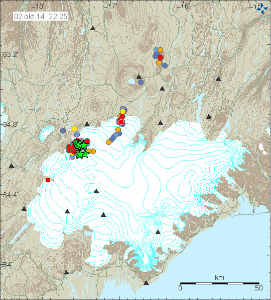
The earthquake activity in Bárðarbunga volcano today and for the last 48 hours. This is just the earthquakes that have been recorded today trough the bad weather that has been taking place. So I am expecting more earthquake to have taken place than are showing up here. Copyright of this image belongs to Icelandic Met Office.
When the earthquake data is connected to GPS data it tells the story of an dyke that is being well fed and is trying to expand into nearby crust. Creating minor earthquake activity in the process. It is erupting so it can only expand by the volume that the eruption is not erupting. I don’t know how much that is, the dyke it self is around 3 – 4 meters wide and around 10 – 15 km deep (best estimate).
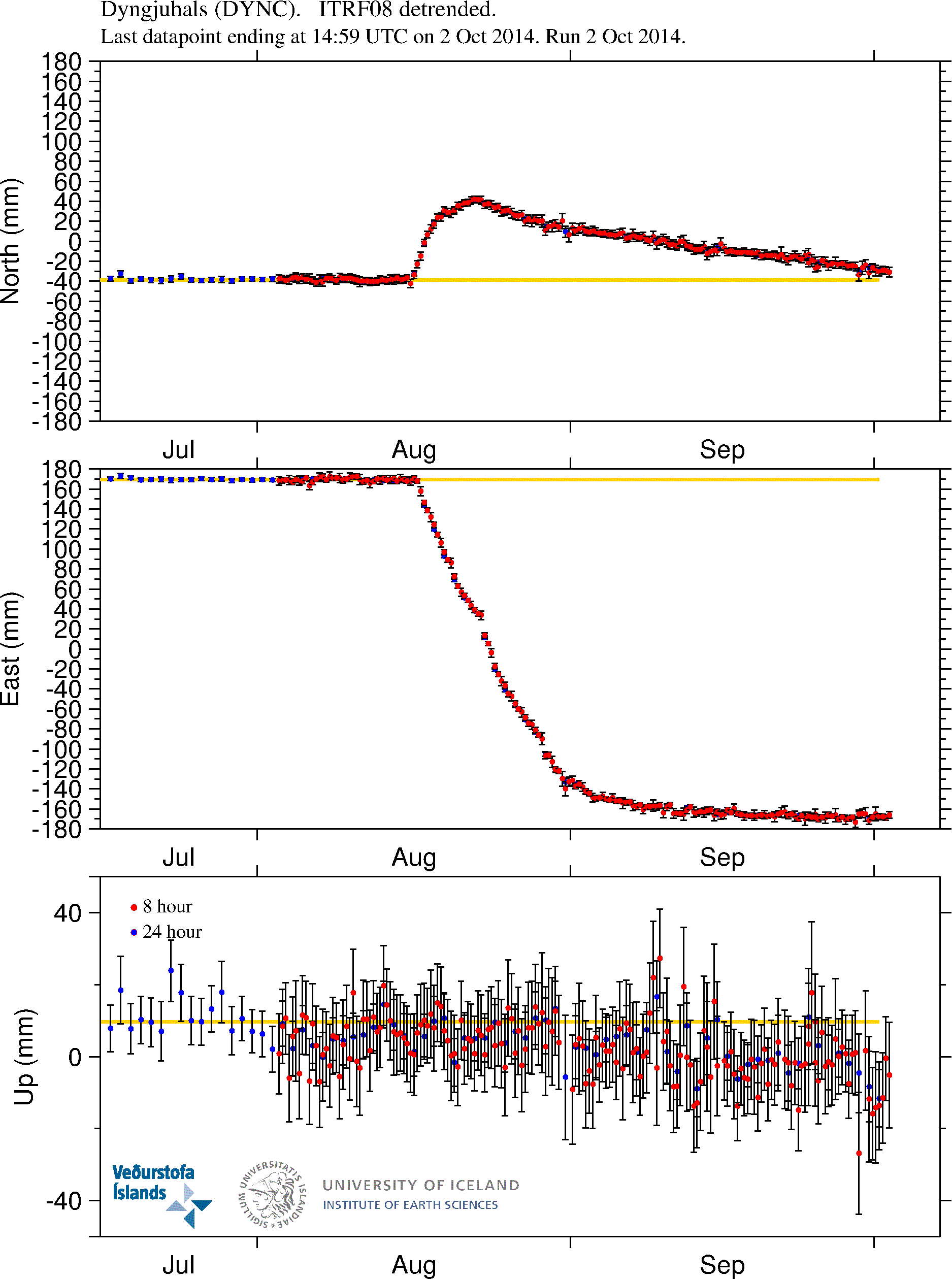
The dyke size and feeding appears clearly here. I don’t know why it is moving west now, rather than east. This might suggest that something else is going on that does not appear on the surface yet (it might never appear on the surface). Copyright of this image belongs to University of Iceland.
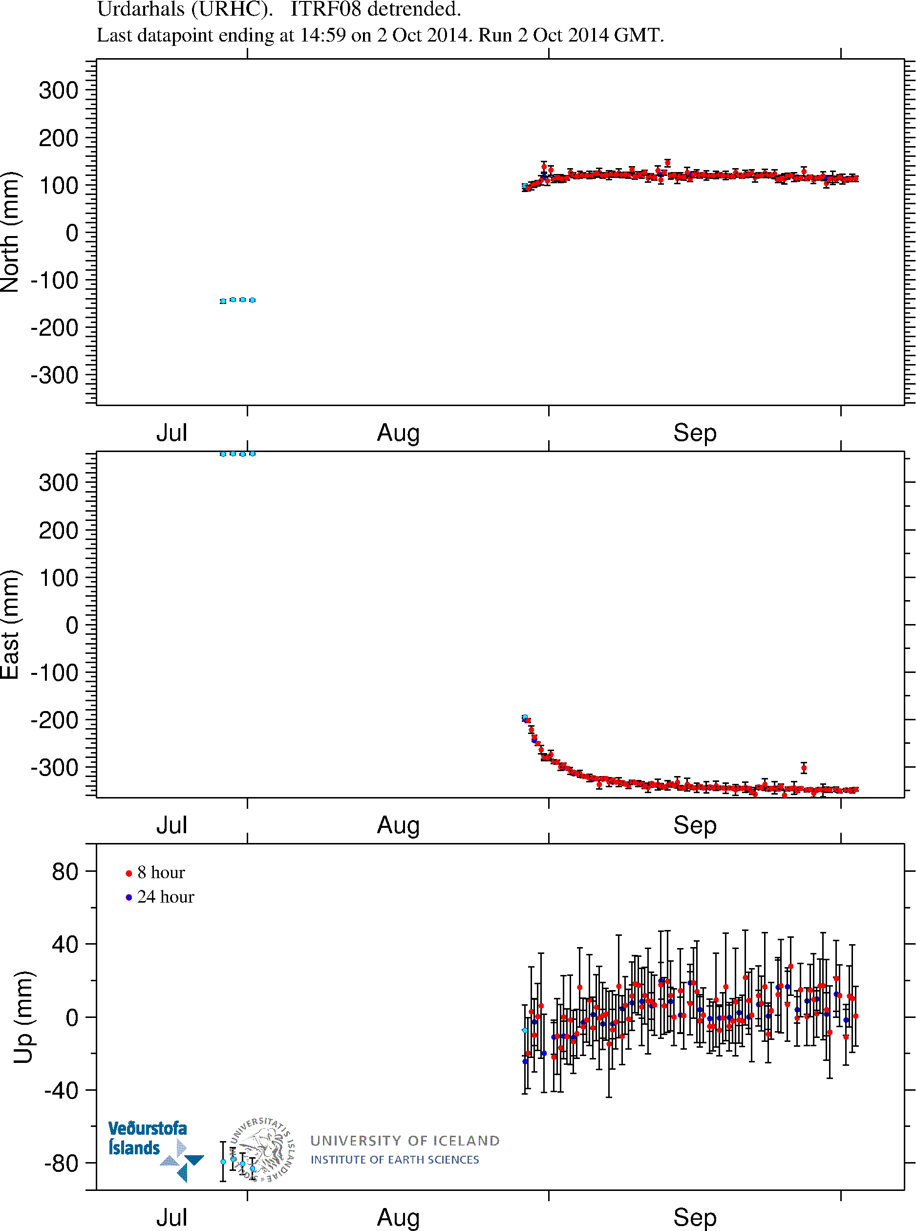
It is almost the same story on this GPS station. With the exception it is not moving to the west. It is stable where it is. This GPS station is almost on top of the dyke. So any change is going to appear quickly on it. Copyright of this image belongs to University of Iceland.
More GPS stations and information can be found here on University of Iceland website.
Break from Friday
I am going to go on a little break during this weekend from Friday. This means the following.
- Comments are going to stay a little longer in moderation queue if you are commenting for the first time, or posting many links. If your comment vanishes it means the spam filter ate it, so it is going to take me a little time to recover it. So just wait a little for it.
- If anything happens I might not be able to update this website with newest information right away. I will try to do soon as possible if I can.
- Update for the Friday (03-October-2014) might be short and come in late (or not at all). When I don’t know yet.
This has been a busy one and half month for me. I’ve been watching Bárðarbunga volcano for almost all hours of the day regardless where I am and what I am doing. After a while it starts to tire you. That is why Icelandic Met Office and University of Iceland have people on rotation during this eruption. I don’t have that option so I just have to take a short breaks and hope nothing big happens while I am resting my self for a short while.
I did learn during the Eyjafjallajökull eruption in 2010 that if I spend too much time in this I burn out and the recovery from that is long process. That is why I now have plan to prevent that during a long eruption, that covers eruptions that are longer than one month. Like is now the case in Bárðarbunga volcano.
I advice this for anyone how is going to watch this eruption for a long period of time (since it is going to last a long period of time). Spending too much time on an eruption is not good. Even a one day break is a good thing for anyone watching this eruption.
In the case there is no new article tomorrow. I wish everyone a good weekend.
Article updated at 23:42 UTC
Article updated at 23:43 UTC
“According to Iceland Review on the 22nd of September, Professor of geophysics Magnús Tumi Guðmundsson told RÚV that as long as the Bárðarbunga caldera is not sinking faster than it has done until now and the eruption in Holuhraun remains stable, the probablilty of a sub-glacial eruption will decrease. The caldera has been sinking at the same rate since then, but everything is still very uncertain, and volcanologist Ármann Höskuldsson disagrees with Guðmundsson, saying that the eruption at Holuhraun is not capable of getting rid of all the magma, so a sub-galcial eruption is getting more likely.”
http://www.bardarbungavolcano.com/Home/News/1111
Here’s an article about subglacial eruptions and ice melt discussing among other things the eruption in Gjalp, which has a comparable amount of ice on top of it, unlike Grimsvotn, where the glacier is relatively thin. Doesn’t address the immediate question, which is how to tell whether the surface of the rock in Bárðarbunga caldera is hot yet. But interesting, what parts I could take in. E.g. at a certain stage in a strong enough eruption we may see an ice piston collapse — presuming a rapid caldera collapse doesn’t obviate that entirely!
http://www.agu.org/books/gm/v140/140GM04/140GM04.pdf
The eruption looks just huge on webcam1 this morning.
on b2 though — just whoa. The dawn light is being cast as this amazing electric blue. I know we all must have huge screenshot collections by now, but it still just amazes me.
Snapshot of it
http://snag.gy/ZcMRo.jpg
The colours were rather astoundishing on Mila2 cam now, contrasting orange and yellow with the black-grey-white background.
On the other hand, this eruption still is a very poisonous one. It was worst in the southern East Fjords yesterday, from Djúpavogur to Fárskrúðsfjörður. Highest measured pollution was 2400 mikrogramm/m3 http://avd.is/is/?p=826 and http://www.austurfrett.is/frettir/2537-haekkudh-mengunargildi-a-breidhdalsvik-og-nagrenni . I just think about all the people I know in this region …
Also accelerated corrosion has been observed in the eastern part of the country, eg. of farmer’s equipment and car parts.
http://www.austurfrett.is/frettir/2518-malmur-til-sveita-rydgar-vegna-eldgossins-eitthvad-sem-vid-hofum-ekki-sed-her
The equipment shown was new 4 weeks ago.
http://i.imgur.com/dzul6rt.png
Here’s that blue color. Just something cam2 was doing to adjust to the faint dawn light.
@IngeB Wow, that corrosion is astounding. Hate to think what it’s doing in peoples’ lungs.
Nice shots! Thank you for sharing!
I’m going to stop talking about the clouds, it makes little sense after what I posted last night!
Pictures of the eruption at Holuhraun / Bardarbunga:
http://www.lukas-gawenda.de/bildergalerie/
Very nice 😀
Excellent photos Lukas. Not just of Iceland, but other parts of the world too.
Its Saturday morning. Where is our little buddy R2D2?
I thot I had not seen him on cam one other day.
The cam 1 is being moved so slowly its almost imperceptible.
Its clearing some so maybe they are closely examining the landscape.
RUV shows winter has arrived.
Vedur shows 2 warnings –
Fissure eruption in Holuhraun (north of Vatnajökull).
Today (Saturday) gas pollution is expected north and also in the northwest in the afternoon of the eruption site.
Tomorrow (Sunday) gas pollution can be expected north and northwest of the eruption site.
I was able to see Bardy either Thursday or Friday, it was very pretty!
A long line of fire across the cam!
For 2 days I have seen Iceland quakes listed on EMSCS, more than usual.
I’ve been too busy with my ebola research for a volcano this week. not good. 🙁
Shepherd,
IMO took R2D2 away and moved him to the south coast( Kirkjubæjarklausur)
have a nice weekend all vulcano fans.
Alex
Some years ago I read a paper about sideways expansion of a magma chamber under a caldera that causes uplift in the surrounding area and the centre of the caldera to sink. The theory goes that sideways pressure causes erosion of the magma walls and the formation of dykes. This has the effect of uplifting the surrounding area, but the rim of the caldera stays fairly static causing the caldera floor to by pushed down as the rim acts as a pivot. This has the effect of causing the caldera floor to eventually collapse in on its self. Since the depression seems to be regular, this would fit in with the uplift in the surrounding area. I have tried to find the article but as of yet have not found it. The only thing I have found was some experiments done in sand boxes (Overpressure experiments of Acocella and Mulugeta (2002).) that have the same sideways expansion of the magma chamber.
http://www.academia.edu/1079991/Understanding_caldera_structure_and_development_An_overview_of_analogue_models_compared_to_natural_calderas
Fig: 10 C shows the idea, however I do not know if the geometry of the area is the same. I may be well out of my league here but what are peoples thoughts
I think you are on to something,and I indicated something similar on the previous page.This is not a sinking lid ,it is a distorting lid
That has the very nice aspect of accounting for that weird steadiness of the subsidence as well as the rest of the data. I like it! (Speaking as just another interested observer of course).
Thank you this was a very interesting read. Really appreciate the insight that this paper offers to the current situation.
An EQ swarm, the largest being 5.0 about half an hour ago. And a drop.
More to the point, that 5.0 quake was reported at only 900m depth, which is very shallow. Recently the largest quakes have been at least 2km and normally around 5km depth.
Data with beachball (GFZ):
http://geofon.gfz-potsdam.de/eqinfo/event.php?id=gfz2014tleu
@IngeB thank you thank you thank you! So that’s not a pure subsidence quake, right? In those you don’t see the double couple. That’s a “normal” quake, one side of the fault slipping down. A subsidence quake would look like an egg with a white center, and an uplift quake would be an egg with a dark center.
So that means some part of the caldera is slipping down relative to the rest of it, along a fault line.
@ingeB
I’m new to that geofon site. Is there a way to get a list of just vatna quakes?
@ingeB
Nevermind … software!! http://geofon.gfz-potsdam.de/software/seiscomp/
… but unduly restrictive in its distribution. I wish science would catch up with the modern world in that regard …
Found their search page finally, not linked in the usual spot — but it’s got a lat-long search that should do nicely!
http://geofon.gfz-potsdam.de/eqinfo/form.php
Are the depths stated in relation to some datum or simply the ground surface?
To sealevel, I’ve read somewhere couple of days ago.
So that the hypocentre would be about 2,9 km below the highest points / lava domes (?) on the caldera rim.
How would they then indicate hypocentres within the subaerial part of the mountain? By – x?
That mag 5 @.9km would make it at the base of the caldera lid. That’s the area of where everyone would expect the beginning of the eruption of Bardarbunga to be.
Loss of lid and complete interaction with magma and glacier when breakthrough is complete .
Something to think about if more follow at this depth.
Indeed, but note there have already been a number of such shallow quakes with no obvious sign they change the big picture.
Looks like a new vent has opened closer to the camera.
http://tinypic.com/view.php?pic=2cgf42&s=8#.VC_7tWcrZOU
I think it is the small one to the right of Baugur (the main active crater) which just widened. The continuation of the fissure is extending into the distance to the left of Baugur, so I think it is anyway part of the same fissure and very probably one of the Baugsbörn. (seen from Mila1 cam).
Positioned to SW of Caldera, that brings Grimsfjall more into play.
According to IMO the 5.o was 4.9 km NE of BB. The usual area. Then the following 3.8 was 4.0 SSW. Is that what you are referring to?
Tyler I agree with you, vents opened there previously but not to this level of output. Two separate plumes visible.
Yes, I see the same here.
In a way, a heightened output would be good as it would take pressure out of the intrusion which otherwise would perhaps open under the outlet glacier Dyngjujökull. Very probably also, the up to now main crater Baugur was about to choke a bit, saw it coughing during the night (small explosions, to be seen eg. on the Kverkfjöll cam).
Yes Kolla, error on my part with the Mag 5 location. But yes the Mag 4 in SW corner was what I was referring to.
Maybe stupid question: Would one see Bardarbunga´s eruption on the mila cam?
The Mila 1 cam is pointed right at Bardarbunga. It´s not obvious though, but it´s the flat white area in the distance.
thanks kolla
Someone on VC mocked this up so this is what you MIGHT and I say that lightly Se if BB went up.
http://volcanocafe.files.wordpress.com/2014/09/bbboom.jpg
oh my gosh!
is ingeb some scientist?=))
@IngeB Do you have a link to the Kverkfjöll cam?
or rather, how do I browse through different dates on this camera?
http://brunnur.vedur.is/myndir/webcam/2014/10/04/webcam_mogt_kverkfjoll.html#
The list of pictures is a the right side…
Sorry, the date … change it in the link to the date you want…
http://brunnur.vedur.is/myndir/webcam/2014/
This the link to I think more cams. Scroll down to kverkfjöll-cam.
The bigger quakes are consistently in the same area in the NE/NNE.
@Kolla – you need to change the date in the address bar to view different days on the Kverfjoll can – to view different times on any particular day there’s a list to the right of the picture, or to view the day’s pics in sequence there’s a keyra button at the bottom of the list
Thank you Mafl and Michelle.
What maybe be happening if magma is close to the surface,is subglacial hydrothermal activity,maybe increased (noisy) tremor related to this activity.If the near surface magma is very viscous and currently not very eruptible,any interaction with ice/water would possibly be just heat related and not explosive?
Has there been found rhyolitic / dacitic tephra from Bárdarbunga central volcano? Or is this an analogy because the neighbouring central volcanoes like Askja have rhyolitic lava domes on their caldera rims?
Or is it because of the GPS data indicating dome formation which would be most often be of rhyolite in Icelandic central volcanoes?
And because of the assumption of an upper magma chamber, which would very probably contain evolved, ie. more viscous material, as the last explosive and bigger eruption in Bárdarbunga central volcano was a long time ago (beginning of 18th century, acc. to GVP http://www.volcano.si.edu/volcano.cfm?vn=373030 )
It is all assumption,but not necessarily an assumption without precedent.I think the way the caldera is behaving gives credence to the higher viscosity magma idea,but that is my opinion and only my opinion.
Thank you.
Think the height datum is 1500 meters above sea level, for caldera top.
They use that, and the DYN as the measurement foci
A 4.9 EQ
At it’s 2.1 km depth
That should have read: And it’s at a depth of 2.1 km. Quality 99%.
EQ swarm back in the Tjörnes fracture zone today (Saturday) yet all below 3.
Like your site a lot and appreciate the effort you put into it. I am not a geologist, but my guess is, that a new phase of the growth of Iceland may have started with the Bardarbunga event. The gap in the mid-atlantic ridge, which goes magma to reachthrough Iceland opened up about 20 cm, Bardarbunga lies right above the presumed Iceland plume or hotspot. So there space opened for new magma to fill this gap and create new earth, which I think is happening now. So far the filling goes peacefully. I guess that, as long as the now existing vents remain open and the inflowing amount of new magma stays the same there will not be a great danger. However this may change when more magma is pushed up from the earth mantle or the vents are blocked.
Where have you all gone ?
I didn’t go to the pub and stayed in tonight !
Even “Wial” and “IngeB” haven’t posted anything for a while!
They all over at VC,only the banned outcasts,such as myself remain
Sorry, was reading some long articles about Tibetan history, after feeling frustrated I’ll never be authorized to use that cool SeisComP® 3 software. 🙂
I was not at VC, just a bit of real life … 🙂
BTW: Good, that you are here, Geyser Soze, like your socratic questions. 🙂
Is there a pattern in this?
In the last 20 days there have been periodic EQ over 4 and 5. Of those 20 days the last 5 have had less intense EQ’s yet more of them. When considering 4’s and the two 5’s it seems there is an overall uptick. The common denominator is continued subsidence of the caldera at the same rate. Just an observation without education around the subject.
May Jon’s rest be rewarding.
Wish there was a “like” button here for us who are not educated in geology or ant sience-math related things 🙂 fun reading so many theories from u guys !
Like
Like
Like 🙂
I take it there’s some weather/cam trouble on mila cams bard 1 & 2, hence no viewable eruption.
Sometimes, it is just the eruption cloud obstructing the view:
http://brunnur.vedur.is/myndir/webcam/2014/10/05/webcam_mogt_kverkfjoll.html#
(eg. 06:50 during daytime, 02:30: during nighttime)
The cloud consists of water vapour (~ fog), SO2 and a lot of other gases as well as sometimes a bit of ash.
And the eruption is back on mila cams… looks different (probably just me!).
green is climbing past red again, gonna see some GPS action in the Bard.
has been the only precursor i have found
http://hraun.vedur.is/ja/oroi/hus.gif
Dear Jon, is there any geochemistry done yet on the Holuhraun lava? Would be interesting if there is visible a magma chamber fractionation or a direct mantle source. It looks on the webcams like an increase in effusion rate, brighter and bigger light at Baugur and larger lava flows. If this continues we have an extrusion size like Laki! That would have a large impact on climate. Many cheers, Stefan
IMO are showing a veritable flurry of M>3’s this morning, including one at a depth of 800 metres.
A whole bunch between 7.5 and 10 km too.
http://baering.github.io/
Around 25 quakes over 3 mag since yesterday. Activity is really picking up a lot! And more appearing in the NW area now too. New dike on the way maybe.
Beachballs! (thanks ingeB)
Using http://geofon.gfz-potsdam.de/eqinfo/form.php
got
http://i.imgur.com/XhDRU31.png which is a screenshot of their kml output in Google Earth, which should be showing beachballs from 8/13 to 10/5/2014.
In Google Earth the individual icons link to their pages on the website when clicked. Nifty!
Note that the icon representation via kml as “normal” faulting obscures the fact a lot of the beachballs are actually non-double couple solutions, which indicate subsidence or multiple faults (ring faults maybe?) You have to look at individual quake pages to get a more accurate portrayal. E.g. http://geofon.gfz-potsdam.de/eqinfo/event.php?id=gfz2014ssqd
If you use this site, go easy on their server. Apparently people abuse it and they have to block ip ranges.
Here’s the wikipedia on beachballs. I’ve read better explanations but this should be a start. http://en.wikipedia.org/wiki/Focal_mechanism
PS Jón if you see this first don’t bother to rescue my first post — forgot there’s a limit on number of links per comment.
So todays work for me: Understand the beachballs…my english is bad, the german wiki is to short and missing some pictures and to much foreign words… 🙁
@Mafl Let me try a simplistic (and quite possibly garbled) explanation.
When a big-enough earthquake happens, its signal is picked up by multiple sensor locations, sometimes as far away as different continents. The beachball (aka moment tensor or earthquake focal mechanism) is sort of a picture of how the same wave looks different to all those scattered stations. Scientists have found P (pressure) waves picked up from the same quake will be recorded with the line starting out moving up to a peak in one location, and down to a trough in another. The pattern of peaks vs troughs divides up nicely into quadrants on a map of sensor locations. Where the wave starts out moving up, that’s where moving rock is moving towards the sensor crunching together. This is portrayed as dark on the beachball. Where the starts out down the rock is moving away, stretching apart, and that’s shown as white. On the other side of the fault you get the opposite effect, so stations on that side will see down-starting waves in the same half where up-starting waves are seen on the other side of the fault. So from that they can tell the direction the fault lies in the Earth, or rather, make a 50/50 guess (due the way it splits into two dark and two light quadrants) and confirm it looking at known geography.
Now, in some single fault quakes the faults slip sideways, others one side pushes up over the other, still others one side slides down. Each different kind of quake gives a distinctly different appearance to the beachball, such that the arrangement of the light/dark panels on a beachball gives the trained eye an instant clue as to what happened. Thankfully, there are visual guides online to these different appearances and what they mean.
Not all quakes are caused by slippage at a fault line, or a single fault line. These more complicated quakes result in non-double-couple mechanisms– they don’t produce that nice pattern of quadrants, but instead a fried egg like appearance, either with a dark center or a light center. Some of these are the result of more than one fault slipping at the same time, or the fault being drastically curved (e.g. ring faults in a caldera), but usually, ones with a white center indicate volcanic subsidence, and ones with a dark center indicate uplift. Back in 1996 the BB beachballs all had dark centers, now the centers are all white.
Note too beachballs are used to sort out nuclear tests and other large explosions like meteor strikes from true earthquakes, because these events will result in a distinctly different kind of beachball yet again.
I found one video that was particularly instructive, but lost it again…wait I googled my own comment from Sep 8 🙂 https://www.youtube.com/watch?v=MomVOkyDdLo
Very nice work, wial, thank you. 🙂
Wonderful wial! Even I understood that. Thank you 🙂
It´s noticeable how the 3+ EQs have been picking up in the last 10 hours or so. It´s a different pattern than previously seen.
Another satellite picture of the lava field, from 16th September (credit: DLR).
They did an overlay of 3 actual pictures and marked the differences with colours, yellow is the beginning of the field (til Sept. 4, there is an error in the text, the author thought it began on August 13), red til Sept. 16.
http://www.dlr.de/dlr/desktopdefault.aspx/tabid-10231/336_read-11583/#/gallery/16454
High seismic activity at Grimsfjall ? The blue lines seems very thick since midnight (bit like me)
What does this mean and does it correspond with a high number of +3 EQ’s ?
After all this shaking the rock must now be permeated by inumerable cracks many of which are too small to allow for magma propagation but most of which are large enough to let water propagate.
So I am imagining a scenario whereby at the bottom of the glacier melt water is forming at extreme temperature and under enormous pressure and is finding its way into these cracks leading to increasing H2O loading far into the surrounding rock.
My question is if this is possible and if so if it could be significant for further developments.
Maybe the magma under the caldera is of a consistency similar to the surrounding rock,not like the magma seen at the fissure eruption,this moves through the rock like a very thick super heated paste?
In my desire for apocalyptic action I envision the following scenario:
Melt at the caldera bottom with subsequent migration of water into cracks in superheated state.
Development of the rock into a waterlogged sponge.
Migration of the magma into the waterlogged rock locally widens cracks leading to water depressurization (before the magma can fill in the newly created space) with ensuing local steam explosion.
This explosion forms further cracks –> positive feedback ensues.
wtaer in cracks also has the beneficial effect of accelerating heat transport to the bottom of the glacier, which iduces even more melt.
All in all there is much potential for positive feedback and that can only end in one fashion: the system must blow up.
Don’t know, if you have this link for the mogt webcams:
http://vefmyndavelar.mogt.is/
The Grímsfjall cams btw. are snowcovered at the moment, it seems.
They are back online. 🙂 thx Inge!
what’s with or Kópasker on?
I see today and earlier regular activieteid
source: http://hraun.vedur.is/ja/englishweb/eqlist.html
5-10-2014 10:51:03 66,247 -16,589 4,7 1,2 90,02 8,6 km SW of Kópasker
5-10-2014 10:47:33 66,249 -16,578 4,6 1,1 90,03 8,1 km SW of Kópasker
5-10-2014 10:41:21 66,253 -16,550 5,1 0,3 68,31 7,0 km SW of Kópasker
5-10-2014 10:39:36 66,263 -16,521 7,7 0,3 47,3 5,3 km SW of Kópasker
5-10-2014 10:07:38 66,256 -16,560 3,4 0,5 90,01 7,0 km SW of Kópasker
5-10-2014 9:46:10 66,261 -16,539 6,2 0 36,09 6,0 km SW of Kópasker
5-10-2014 9:38:03 66,255 -16,567 5,6 0,4 72,31 7,3 km SW of Kópasker
5-10-2014 9:34:49 66,238 -16,586 1,6 2 90,04 9,3 km SW of Kópasker
5-10-2014 9:15:23 66,266 -16,558 5,4 0,8 90,02 6,2 km SW of Kópasker
5-10-2014 8:59:00 66,255 -16,540 6,1 0,2 74,65 6,5 km SW of Kópasker
5-10-2014 8:08:09 66,259 -16,535 6 -0,1 44,02 6,0 km SW of Kópasker
5-10-2014 5:56:15 66,268 -16,582 7 0,7 47,41 6,9 km WSW of Kópasker
5-10-2014 0:01:24 66,253 -16,541 5,9 0 50,95 6,7 km SW of Kópasker
4-10-2014 23:30:19 66,263 -16,531 6,6 0,1 47,88 5,6 km SW of Kópasker
4-10-2014 16:20:12 66,256 -16,546 4,4 0,6 90,02 6,6 km SW of Kópasker
4-10-2014 15:44:24 66,256 -16,542 5,4 -0,3 33,81 6,5 km SW of Kópasker
4-10-2014 15:37:59 66,254 -16,554 5,5 0,3 68,35 7,0 km SW of Kópasker
4-10-2014 15:36:13 66,252 -16,538 5,9 0 38,93 6,7 km SW of Kópasker
4-10-2014 16:20:13 66,221 -16,600 1,1 0,6 90,01 11,1 km SW of Kópasker
4-10-2014 11:10:53 66,257 -16,539 6,9 -0,2 50,21 6,3 km SW of Kópasker
4-10-2014 9:41:09 66,228 -16,850 11,4 0,3 64,7 19,6 km WSW of Kópasker
4-10-2014 9:25:33 66,251 -16,542 5 -0,1 43,9 6,9 km SW of Kópasker
4-10-2014 7:29:22 66,241 -16,544 6,1 -0,1 38,73 7,9 km SSWof Kópasker
4-10-2014 7:06:07 66,250 -16,550 5,5 0,4 80,97 7,2 km SW of Kópasker
4-10-2014 5:02:34 66,254 -16,588 6,3 0,5 90,01 8,1 km SW of Kópasker
4-10-2014 2:47:50 66,239 -16,572 3,9 0,7 90,02 8,8 km SW of Kópasker
4-10-2014 0:44:43 66,239 -16,566 3,5 0,5 90,01 8,6 km SW of Kópasker
3-10-2014 18:54:19 66,290 -16,548 11,2 0,1 49,91 4,5 km WSW of Kópasker
3-10-2014 18:12:42 66,216 -16,565 0,6 -0,2 48,49 10,8 km SSW of Kópasker
Jón wrote about this here:
http://icelandgeology.net/?p=5089
Okay. thanks for your reply, but that was an explanation of 02-Oct.
This activity is now clearly grown. would this situation knower shelf truly have not changed?
If you choose theJons post from 2. oktober, under his text you see the categorie TFZ. There you can see all the older posts about the swarms back to min. 2012.
http://icelandgeology.net/?cat=44
@Andre I don´t know much about this area except that EQs are very common there. In other words, this happens on a regular basis and has for a long time.
This is what it looked like back in 2012.
http://beforeitsnews.com/alternative/2012/10/tjornes-fracture-zone-north-of-iceland-experiences-strong-earthquake-swarm-with-magnitude-5-2-quake-2483766.html
.And often more than this, for a long period, all over the TFZ area in 2012. It has been more quiet there for a couple of years. Maybe a new period with increased activity will pick up now. The Tjørnes Fracture Zone is known for a high seismic activity and big quakes.
Hi, further to my post earlier, I have managed to find some note books from a gap year from university were I was taking geology, dating back to 1968. It might be considered a bit off topic but if you read on I’m sure you will agree it has some very similar things with what is going on at BB. This is only what I think may be going on. I never finished university due to things I could not control so I am not qualified in any was and only have a deep interest in volcano’s and earthquakes from this time.
Let me explain. I was lucky enough to get 3 months field work in the Phlegrean Fields system back in 1968 with a team investigating certain anomalies found during some underwater surveys done in 1964. It was found that there seemed to be evidence that earlier caldera’s appeared to be smaller than the current caldera (however the present caldera is not that well defined.
The investigation was to try and look at a theory that during the last major collapse, the caldera had been enlarged. This was thought to have been caused by lateral intrusion of magma out through the sides of the magma chamber. I always remember what the team leader said that this caused a donut shape magma chamber that led to the eventual collapse of the system.
Let me explain. Magma was thought to have moved sideways causing uplift in the surrounding area. At that time the caldera rim was firmly anchored to the bedrock and these intrusions of magma seemed to have collected in a ring around the original caldera. This caused uplift around the caldera and subsidence inside the caldera like a giant seesaw. (The same thing is happening in certain areas at the present within the Phlegrean Fields system). Eventually the support for the caldera rim was eroded and failed causing the whole old caldera to collapse leading to the eruption that formed the present day caldera, some 5km wider than the original.
What we are seeing at BB seems to be very similar, we have uplift around it and know there is some magma intrusion out the sides of the magma chamber. There must be to fuel the uplift. If the caldera rim is still fixed then the pull effect of the rim will cause land movement towards the center, which has been reported. This would also have the effect of forcing the caldera floor to move down, which it is. I am not suggesting that the whole caldera is about to collapse, but the idea that inflation of the surrounding area due to over pressurization of BB’s magma chamber could be one of the factors that is driving the downward movement of the caldera floor. AS said earlier this is only my thoughts on what might be happening.
Would crust thickness contribute.
http://www.tobias-weisenberger.de/6Iceland/Introduction/Abb2.4.jpg
“Recent models agree that the crustal thickness varies from about 45 km under the Vatnajökull glacier to less than 20 km under the northern part oft the Northern Rift Zone and the Reykjanes Peninsula (Fig. 4; Darbeshire et al. 2000; Kaban et al. 2002).”
Dr. Tobias Weisenberger
I think the cited text is based on this one:
http://www.geotop.ca/pdf/darbyshireF/Darbyshire_et_al_EPSL_2000.pdf
Would a thicker crust make isostatic adjustment more difficult, ie. no easy compensation for downward movements? On the other hand, would not the crust beneath such a big central volcano be more flexible under the influence of weight and heat of this mountain?
I think that would fit the “distorting lid” Geyser Soze mentioned here in this blog (16:58, yesterday).
Would it also fit the cryptodome theory Geyser Soze brought forward (3 Oct, 14:59) ?
And I think I remember correctly somebody mentioned that at least some part of the magma chamber was thought not to be directly under the BB caldera, but further to the NE.
” I never finished university … and so I am not qualified”
The correlation between finishing university and beeing qualified has been steadily decreasing lately.
Lately? Heh, that has been a truism for decades now, it simply getting worse. Instead of having a degree in “Advanced Fingerpainting”, now you can get a degree in “Advanced Thumbsucking” from college.
Wow! Clive, your theory makes a great deal of sense, and I am hoping we are starting to get some clues to the mystery of BB’s ups and downs. I hope Jon, when he gets back from his holiday, will help us with his thoughts on your ideas.
The uplift of the surrounding area is not that big though, according to this
graph.
However we need not give up hope yet.
This seems to be early innings.
And there is certainly enough
supply of magma below iceland to keep going for a couple of millions of years.
Sorry, I linked to the wrong graph.
here is what I intended.
My thought is that it doesn’t have to be that big, think of a lever long arm one end and short the other. One end moves a little other end moves a lot.
This works if the pivot point is close to the caldera rim as it is in your theory.
Think of it as more of a push pull action,push on the rim and pull on the caldera floor.Then the magma being squeezed past the rim must be of a high viscosity,the lower viscosity and higher temperature basalt is the driver?Magmatic temperature is the driver of all the activity?.Just my thoughts
lt also supports the “donut” idea I mentioned numerous times on VC,much to Carl’s disgust
Now, why am I not surprised about on how things developed there for you … 😉
BTW: Could you perhaps explain the “donut” idea here also?
Well the way I envisaged it,there is wide but shallow magma chamber under the caldera floor.This is composed of a viscous evolved magma ,periods of basalt heat intrusion since caldera formation causing the evolved magma to migrate towards the rim,the chamber becomes increasingly biased towards the rim and thinner towards the centre.This central relative lack of depth allows more deep basalt related heat to infiltrate the upper chamber,until a tipping point is reached or basalt intrusion subsides.In a full scale caldera eruption the basalt intrusion makes the central chamber buoyant causing the eruption to commence which feeds of the outside of the “donut”.That wild theory is what gets me banned lol
Magnús Tumi Gudmundsson in his hazard assessment, does not mention the risk of a silic eruption ( http://en.vedur.is/media/jar/Bardarbunga_kafli20140825.pdf ). During tephra analysis of Icelandic explosive eruptions around Vatnajökull, there was mostly found basalt from Bardarbunga.
On the other hand, there exists no comprehensive analysis of all explosive eruptions in Vatnajökull during the Holozene (a lot may be under the glacier or eroded). What would speak for – anyway pockets of – felsic material, are also some other arguments:
– the last explosive eruption in Bardarbunga was at the beginning of the 18th century and just a VEI 3 (acc. to GVP), so whatever that may mean re. expelled material vs. magma that had some time to evolve in a magma reservoir up to now ;
– the magma mixing during the Gjálp eruption: andesite / icelandite found – and they will not originate from the notoriously basaltic Grímsvötn volcano;
– there was anyway found 1 silic tephra layer within the tephra layers from Vatnajökull, though its origin is unknown (could of course easily be from Kverkfjöll).
If that is what he says,I am not going to question it.These are just the musings of the interested ,nothing more nothing less.
I like the donut image a lot — but it makes me wonder, if the core of the chamber is no longer molten (not saying the donut image necessarily implies that) wouldn’t we see more earthquakes in the center of the caldera?
No you misunderstand my meaning, you still maintain the normal core, but the leaking magma forms a ring outside the caldera rim. So in effect you get 2 magma chamber’s one in the center and one forming outside the rim. How it was explained to me was the outer band or donut is made up from many fractures were the magma has been able to leak out of the main chamber. Its not a full blown magma chamber just many intrusions that start to link up outside the rim. As pressure grows these join ups become more and more frequent till you have the donut ring outside the rim. No explanation as to how this happens only that it was thought that the magma was very hot or the sidewalls of the magma chamber became ruptured over time. As I said it was a new theory that was being investigated, and as a student, we were not privy to the final results. The last I heard was that the investigations were ongoing but that was in 1970.
As to the more EQ’s in the center, if the top of the rim is being forced inwards and the bottom pulled out you would get a squeezing effect with most of the strain on the edges of the caldera floor. hence the quakes around the rim. The centre of the floor would follow the edges down, there might be some distortion but I think it would gust move with the edges.
The earthquakes are on the rim because that is where the energy from the heating of the chamber can be released via the surrounding country rock?Maybe Bardarbunga is more like a donut with a big bite out of one side?
looks like whatever that device was in the webcam view with the blinking red lights blew away in the storm last night. It’s no longer there.
It was moved a couple of days ago to a new location.
That was the radar R2D2, they transferred it to Kirkjubaejarklaustur in the south of Iceland. Winter arrived in Iceland.
On Mila_2 it seems like a second vent has opened up.
At least a second point source of gas is visible.
Somepins definitely afoot:
So far 7-10 earthquakes mg 3+ a day.
Yesterday 15 such quakes
Today already 20 such and the day is not over yet.
Seems like a new vent opened after a bunch of 3+EQs….if so, might cause a lot of pressure drop in caldera? We shall see…
And the subsidence is slowing down drastically…
I can’t see that actually. When this change in behaviour should have begun?
I think you may find that the activity maybe counter intuitive,a slowing of the subsidence does not necessarily mean the process is ending?