
This is out of sync update of the eruption in Bárðarbunga volcano. This website was dealing with technical problems when it was moved to a new server. I hope that has all been resolved now. This new server should be more responsive than the server I used to host my website on. This was sudden move between servers, but it had to be done since the traffic to this website was overpowering the server I was using and my website had already been suspended once due to this.
Bárðarbunga volcano update
The eruption continues in Holuhraun around the same rate as before. During the Christmas time there has no travels of scientists going to the eruption area. The main lava field is now around 83 km³ in size according to latest reports. This number changes frequently.
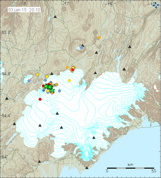
Earthquake activity in Bárðarbunga volcano for the last 48 hours. Copyright of this image belongs to the Icelandic Met Office.
Largest earthquake during the past 24 hours had the magnitude of 4,6. Number of earthquakes in that same time period was 50 according to the news. Pollution from the eruption continues to create problems in Iceland depending on wind direction. Yesterday and last nigh the pollution did go up to 900 μg/m³ in Egilstaðir and up to 2400 μg/m³ in Höfn in Hornafirði. Wind was rather strong during that time (I think) so the pollution did not stop for a long period of time or build up.
Other discoveries
Scientists have discovered that dyke activity in Bárðarbunga volcano appears to be creating new layers of crust at depth. I don’t have the details on this , I did see this in the news few days ago, but I lost the news about what this is exactly about. I hope to get more details later about this.
Donations
Since I had to move to a new host, the cost for me with this website has gone up. The cost of just running the website is now $135 a month. Any donation to help me with this cost and more are welcomed, it is also possible to support me by using Amazon advertisements that I have by buying from Amazon what you need. Thanks for the support.
Thanks Jon,
Am curious how they detect the building of new layers of crust.
I assume it has to do with recording, analyzing, measuring reverberations from normal earthquakes and/or seismic testing e.g. for oil etc???
I think this is in relation to this article:
http://www.leeds.ac.uk/news/article/3642/scientists_observe_the_earth_grow_a_new_layer_under_an_icelandic_volcano
Rifting events seem to build up new crust at the diverging plate boundaries by injecting dykes into the crust.
If the crust is thickening by intrusions, that has to be in a horizontal matter, so these intrusions are called sills. Vertical dykes are feeding the sills with magma. The sills can be many hundrets of meters thick and can have coarse grained textures towards the middle depending on cooling time.
And, I wonder what the implications of the new layers of crust upbuilding might turn out to be. . . . a decrease in vulcanism?
And would these new layers be on both sides of the rift or what?
It has to do with the mechanisms of plate tectonics and seafloor spreading (the same mechanism here as out on the Mid Atlantic Ridge, just on land), but in the case of Iceland, there is also a Hot spot at work, so the volcanism won’t be reduced.
On plate tectonics (in this case, we have diverging plate boundaries in Iceland): http://www.ucmp.berkeley.edu/geology/tecmech.html and http://science.nationalgeographic.com/science/earth/the-dynamic-earth/plate-tectonics-article/
On hot spot volcanism: http://volcano.oregonstate.edu/hot-spot-volcanism
The definition of a hot spot (in geology) from the same website, citing: A volcanic center, 60 to 120 miles (100 to 200 km) across and persistent for at least a few tens of million of years, that is thought to be the surface expression of a persistent rising plume of hot mantle material. Hot spots are not linked to arcs and may not be associated with ocean ridges.
Acc. to this, it is an exception that there is a hot spot on an ocean ridge (the Mid Atlantic Ridge). The plates have been wandering over it, 60 mill. years ago it was under Greenland and in the beginning it caused perhaps even the Siberian Traps 250 mill. years ago. http://vulkan.blog.is/blog/vulkan/entry/1561030/
I think it is a bit weak by the authors of this paper to talk about crust thickening when they actually talk about vertical dyke implacemet. The crust is then growing in width (the extra meters of the dyke thickness), and is not thickening. If they would talk about new sill implacements, then they could call it crust thickening. The piling up of lava sheets extruded at the surface can also be called crust thickening.
I think the same, Stefan. Not very well defined terminology in this article.
Saturday
03.01.2015 12:01:11 64.670 -17.494 8.3 km 4.5 99.0 3.6 km NNE of Bárðarbunga
Hello everybody,
A little while back I noticed (probably like all of you) that the announcement of the fissure eruption at Holuhraun on the homepage of Vedur.is that had been there for nearly 4 months, had dissapeared.
Does any of you know why IMO did this?
Kind regards,
Henk Weijerstrass
Holland
They did it simply because of the situation not really developing in any drastic way. The announcements are after all there to inform the public about (potential) hazard, which the eruption at Holuhraun currently is not. So keeping the banner would be to ‘cry wolf’ in a way, I guess.
There should be an article or note on this somewhere, but I cannot find it. However, it was brought to my attention on this blog when it happened.
Ah, here’s a link to go with my rambling above:
http://en.vedur.is/about-imo/news/nr/3046
Dear Z.,
Thanks for your explanation; I must have missed the announcement from IMO.
When I noticed from other comments that the eruption was still ongoing, I allready guessed that something like you told me, happened! Anyway thanks for the link to the IMO message!
By the way: what country are you from? (just out curiousity ☺)
Kind regards,
Henk Weijerstrass
Holland
Happy to help out!
I’m from Sweden.
The eruption looks lovely under the moonlight. It also shows that no major change has taken place in the eruption at the moment.
Upper GPS graph is back -> http://hraun.vedur.is/ja/Bardarb/BARC/
New satellite image of Nornahraun -> https://twitter.com/icel_eruptions/status/551665729578487808/photo/1
I can’t help noticing that many of the recent EQ’s of greater than 4.0 have been very close to the surface at 0.1km. Is there a particular interpretation which suggests itself in relation to this pattern?
I am very much looking forward to Jon’s alluded to future comments on lava layering.
Earthquake felt in Furnas (São Miguel – Azores)
04/01/2015 09:44:15 37 777 -25 358 2.0 ML Furnas (São Miguel) II / III St. Michael: Furnas
Source: CVARG
It’s a day of some activity in São Miguel, probably to the area of Furnas/Povoação/Ribeira Quente, I see the seismic station of Fogo, may have occurred more than 12 earthquakes with magnitude lower than Ml2.0. The largest earthquake of magnitude not cataloged by IPMA / CVARG was at 10:05, must have a magnitude of ~ Ml1.5.
For two days ago, an earthquake of magnitude Ml1.5 was felt in Povoação (CVARG Source). http://www.meteopt.com/forum/topico/sismos-portugal-2015.8078/#post-468126
This is the last info : 04/01/2015 20:00
S. Miguel, Furnas
CIVISA continues to record seismic activity in the area of Furnas, S. Miguel Island
The Center for Information and Surveillance Sismovulcânica the Azores (CIVISA) informs that from 00:00 hours (local time = UTC-1) on January 4 is experiencing some seismic activity above normal values, an epicentral region between 4 and 5 km W Furnas, S. Miguel Island.
Up to 20: 00h (local time = UTC-1) were recorded about 30 events, all of low magnitude, with the strongest occurred at 08:44 hours (local time = UTC-1), with magnitude 2.0 ML (Richter ). This earthquake was centered about 4 miles W of Furnas and was felt with maximum intensity II / III (Modified Mercalli Scale) in Furnas, Village municipality, São Miguel island.
Under the geological point of view, the seismicity is developed in the flank of the Furnas Volcano W, specifically, in a range of NNE-SSW where the edge of the external boiler Volcano Furnas is intersected by the approximate direction of WNW-ESE fractures the fissure Volcanic System Conger. http://www.cvarg.azores.gov.pt/Paginas/home-cvarg.aspx
All Azores activity here: http://www.cvarg.azores.gov.pt/civisa/Paginas/homeCIVISA.aspx
A bit of information on tectonics and volcanism of the Azores:
http://volcano.oregonstate.edu/vwdocs/volc_images/africa/azores/tectonics.html
Thank’s a lot Inge!
What also seems interesting is, that during the latest eruption series in this archipel, ie. 1957-58 during the surtseyan Capelinhos eruptions, there was a connected series of around 200 earthquakes over 5 on the Mercalli scale (which should be around 5 on the Richter scale also), if Wikipedia has it right. https://en.wikipedia.org/wiki/Capelinhos
[edit]
Wikipedia has it always right.
Hey Luis,
I think so far its normal activity, it happens regularly and such small quakes (M2) felt locally must therefore be shallow.
Also a M4 today in Azores in a place much more restless lately (several M3+ quakes in past weeks), but out in the sea. That sort of activity is quite worth to follow.
I hope that the new server is working correctly for everyone.
Yes, no problems so far.
Jon and IngeB: The misleading reference to crustal “thickening” appears to result from a Leeds University press officer’s cavalier interpretation of the recent paper in Nature by Sigmundsson, Hooper et al. (2014), entitled “Segmented lateral dyke growth in a rifting event at Bárðarbunga volcanic system, Iceland”:
http://www.nature.com/nature/journal/vaop/ncurrent/full/nature14111.html
As its title suggests, this paper is all about crustal extension related to the dyke.
I also thought about a slight misunderstanding by a spokesperson of the university.
Has anybody had a look at the earthquakes at Bárdarbunga today? Two of the 4+ have a depth of 0,1 km. Rockfall in a ice cavern at the bottom within the inner rim of the caldera? Or subaerial at the outer rim?
And then there is a very deep one 2,1 km SSW, which should be within the caldera .
05.01.2015 00:11:37 64.622 -17.542 14.4 km 3.3 99.0 2.1 km SSW of
Bárðarbunga
A new batch of magma intruding from the deep reservoir? Or is it perhaps tectonic as there was no other earthquake following at about the same location or a similar depth. There were just some between 10 and 12 km in the north of the volcano.
There was also a very pronounced westward movement of station HAUC today without the other stations moving. Some local uplift within the Tugnafellsjökull or Hágöngur volcanic system? http://www.vedur.is/skjalftar-og-eldgos/gps-maelingar/bardarbunga/ Or just ice on the antenna again?
Magnitude 5.1
Region ICELAND
Date time 2015-01-05 21:53:22.4 UTC
Location 64.68 N ; 17.66 W
Depth 10 km
Monday
05.01.2015 21:53:21 64.550 -17.790 1.1 km 5.0 50.5 7.1 km N of Hamarinn
Since the M3.5 in Geysir last month, I stepped up my own daily monotoring of earthquakes. Since then, everytime I feel a minor vibration at home or at work, I quickly register the time, just to see whether I catch a tiny earthquake or not. Actually I was on the hopes to catch another Geysir quake. Call me crazy yeah
Today I caught the moment of another quake. At around 21:54 I felt a very slight vibration like a passing car but without noise, register the timing, and a few mins later, realized yup, it was probably this last M5 quake at Bardarbunga.
It was the second or third Bardarbunga quake I felt here in south Iceland, but this one it had to be felt by very attentive awareness.
But no one, in their own evening tasks could ever bother with such minor almost unperceptible vibration. But it is just a reminder of how strong activity still is, there is the faraway highlands.
My friend this big quake is really near Hammarin? He is awakening? Thank’s!
Ney, dont think so. I think its Bardarbunga, otherwise they would record other smaller quakes, and lots of them, at Hamarinn.
But this is something interesting. Twice I felt an earthquake here from Bardarbunga and twice it appeared first as wrongly located at Hamarinn or further west.
IMHO I think its the EQ wave propagating somehow (in these quakes) more easily towards the west side of Iceland rather than towards the north. But I am not an expert with this.
Usually most M5+ Bardar quakes are felt clearly in Akureyri but never elsewhere in Iceland. There are quakes which seem to be an exception.
Hamarinn was awake in summer 2011. Remember that Luis?
There was a subglacial unconfirmed eruption there, at least we suspected that. Tremor was very high and a flood followed.
Since then Hamarinn is rather calm, and we really hope so, because any rifting starting there would propagate southwestwards. But that’s not happening at the moment.
Thank’s! And yes i should say re-awakening…
Eruption is quite strong and bright now (both Mila cams), and with great visibility. Perhaps fuelled by the recent M5+?
M4.9
Could the activity could be counter intuitive? Could the lesser number of quakes be due to a change in the state of the caldera shallow magma reservoir, hotter ,lower vicosity, gas content (foam)?
Which could also fit the changed picture at the GPS graph: http://hraun.vedur.is/ja/Bardarb/BARC/
But I think, there was a IMO remark that it still does not yet work correctly. I don’t know if this caveat is still valuable.
Hi Inge,
what do you mean with “changed picture”?
BTW: I believe IMOs remark is older … from the time when the upper graph doesn’t work.
Partial translation of an interview with geophysisist Páll Einarsson: http://icelandreview.com/news/2015/01/05/bardarbunga-may-impact-other-volcanoes
BTW: Torfajökull is not in the north, but in the southwest of Bárðarbunga. –
And because of this, quakes to the southwest of the volcano are not really good news… On the other hand, the quake was still within the caldera, so …
The Icelandic text and the radio interview are here: http://www.ruv.is/frett/bardarbunga-alheppilegasta-atburdarasin
Iceland has a new geyser: In a geothermal area in the north of the country, near the central volcano of Þeistareykir, people from a power company tapped unwillingly a steam hole, which resulted in a man-made geysir that expulses water columns of up to 100 m height. http://icelandreview.com/news/2015/01/02/steam-geyser-appears-geothermal-area
New article is up about Bárðarbunga volcano. It also has information about Tungafellsjökull volcano and Hamarinn volcano.