
This is a short update on Bárðarbunga volcano. Due to weather I won’t be able to do full regular updates on Bárðarbunga volcano today. Since bad weather prevented me from getting the computer table that I need to use.
Yesterday (Monday 15-December-2014) an magnitude 5,4 earthquake took place in Bárðarbunga volcano. Earthquake activity dropped in Bárðarbunga volcano following this earthquake. It has however been picking up again in the last few hours.
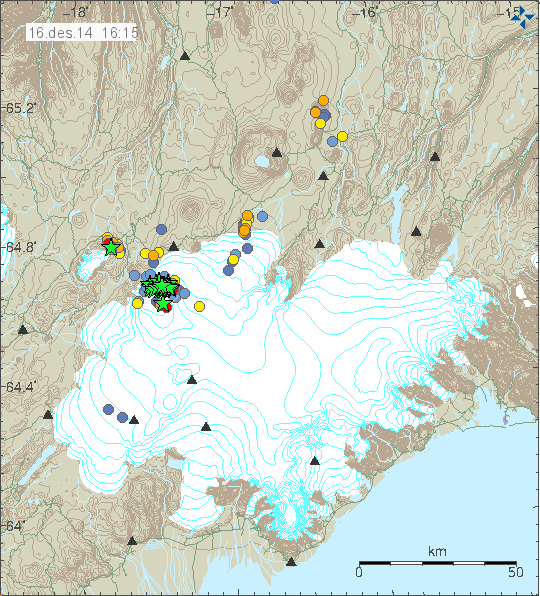
Earthquake activity in Bárðarbunga volcano and Tungafellsjökull volcano for the last 48 hours. Copyright of this image belongs to Icelandic Met Office.
Earthquake activity in Bárðarbunga volcano remains around the same. There have been fewer earthquakes detected due to bad weather happening in Iceland, since wind and ocean noise lower the detection threshold of earthquakes, making it difficult to impossible to record smaller earthquakes. Observations of Holuhraun are impossible at the moment due to bad weather. I haven’t been able to check the web-cameras since my laptop can’t handle it.
Tungafellsjökull volcano earthquake activity has been increasing for the past 48 hours. Largest earthquake in this latest earthquake swarm activity had the magnitude of 3,2. There are no signs of any other unrest in Tungafellsjökull at this moment.
Donations: Please remember to donate to support my work. Buying from Amazon also helps. Thanks for the support.
I was wondering Jon if you had any thoughts concerning the radar image on the 12th? The cauldron certainly appears more developed than before and is that evidence of surface cracking to the north-east of the caldera? I am not sure whether these are older features or they have occurred more recently following the severe barrage of quakes in this part.
Tuesday
16.12.2014 18:57:02 64.620 -17.482 1.8 km 4.4 99.0 3.1 km SE of Bárðarbunga
I forgot to add this to the article. Here are pictures of the original crater row in Holuhraun, this one erupted in the year 1797.
http://omarragnarsson.blog.is/blog/omarragnarsson/entry/1544815/
Thankyou! Great to see this.
Oh, that’s cool. Thanks for sharing!
It has happened before and not a shield volcano to be seen and maybe the seismic activity was present then as well but there was no instrumentation to record it.Unless something significant happens to the glacier,in a few months this could be old news?
There are lots of shield volcanoes north of Bárðarbunga, eg. Trölladyngja could be part of the same volcanic system, a very big shield volcano, also Urðarháls and Vaðalda, the location of the webcams.
On this satellite picture eg., you can see last mentioned shield volcano, just to the northwest of the new lavafield of Holuhraun. http://jardvis.hi.is/sites/jardvis.hi.is/files/myndir/Bardarbunga/yfirlitskort_20141217_0741.jpg
Sorry, meant to the “northeast” of Holuhraun.
So Tungnafellsjokull is keeping up the effort in this drama. I followed the quakes in Vonaskard between Bardar and Tungna for some time. I may have missed some but they seem to not “cross” between the two. There seems to often be activity on both sides of the valley at the same time but in parallel rather than in unison. I wonder what is happening under Tungna and if it is “ripe” for eruption.
Hi Chris, there is a path of minor eqs enroute to tung’s in 3d models which indicate the potential for similar pathway for magma from beneath bb as exists in theory to the holuhraun. I have long believed tung’s and/or the nw caldera wall to be eruptible given their vulnerability to multi planar movement of the hreppar plate.
I consider the consistently high tremor plots from von and dyn to uphold this possibility. The GPS on tectonic shift demonstrates the extreme stresses between the three plates and how much it has varied since the start of the current event. There are so any fractures that deep source cannot be ruled out solely by their proximity to theoretical chamber locations beneath bb. Imho
Muzzy’s latest Bardabunga quake animation:
http://volcanictremor.wordpress.com/
It seems to be coming to an end?Or it is foaming?
http://www3.open.ac.uk/media/fullstory.aspx?id=25369
Wednesday
17.12.2014 09:47:15 64.659 -17.394 4.4 km 4.3 99.0 6.7 km ENE of Bárðarbunga
Magnitude 5.0
Region ICELAND
Date time 2014-12-17 13:58:53.7 UTC
Location 64.74 N ; 17.70 W
Depth 10 km
http://m.emsc.eu/earthquake/earthquake.php?evid=413479
Wednesday
17.12.2014 13:58:49 64.667 -17.507 6.6 km 5.3 99.0 3.1 km NNE of Bárðarbunga
another webcam hero 🙂
http://mynd1.mogt.is/mobile1/images/right/m141217155002355.jpg
from here http://mynd1.mogt.is/mobile1/test.php
Since my dad and mom 3G internet is down due to the storm I won’t be able to update as I planned. What happened is that the 3G antenna was blown off by the wind. I don’t know how long it is going to take until it gets fixed, since the weather forecast for the next few days is not good. I will try and provide short updates if I can. I don’t know if I can write any updates while this happens, but I am going to try and so if I can. I am currently using my 3G connection for my Böðvarshólar geophone to connect to the internet. I am going to use this in next few days just to check in.
I am considering buying my own 4G/3G modem so I don’t have to depend on mom and dad internet connection. I am not sure if I have the money to buy it right now. Such router would cost me €128,30, $159,07 (current exchange rate), ISK 19.990. This is with 6 month contract just for the modem.
Today I had to save Böðvarshólar geophone station from watery doom, since snow had started to blow into the computer (the wind and snow got through the cracks in the window where my geophone is located), the hardware for the geophone and everything was wheat by water from the snow that had melted. That is the reason why it was offline earlier today and did not record the magnitude 5,3 earthquake earlier today. This happens once in a while, even if I do my best to prevent this type of thing from happening.
I won’t be able to post new update tomorrow due to lack of internet connection. Thanks for understanding.
Jón, I just checked some satellite ISP but it looks quiet hard to find one for Iceland…Do you or your neighbors have satellite TV?
No, they don’t. Mom and dad once where once using such connection. It didn’t work at all.
Hello Jon. I just donated 10 euros. This will help a little. Thanks for your efforts to keep all of us informed.
Gary Meyers
Thanks for the support. 🙂
From IMO, of scientific and statistical interest:
http://en.vedur.is/earthquakes-and-volcanism/articles/nr/3039
Credit to Martin Hensch 16.12.2014 for the above article
The lower right-hand plot showing decreasing frequency of 5.0+ EQs in the caldera, is consistent with my previous posting about the statistically significant
drop in the ratio of 5.0+ EQs out of total 3.0+ EQs. thanks.
Have the winds been dropping in strength very recently? The seismometers are picking up a lot of low magnitude EQs around the BB system again.
Here’s the 13,981 quakes on Muzzy’s map compliation . . .
http://files.abovetopsecret.com/files/img/gg5491c9f4.gif
from this page
http://www.abovetopsecret.com/forum/thread988594/pg59
if that first link doesn’t work.
The caldera “cookie” monster has 2 black eyes!What do these eyes mean?
It’s amost artwork.
almost.
Is it logical to assume that the pile of quakes in the ‘black eyes’ areas . . . as well as the North end of the line of dyke quakes are areas of more quake intensity?
And that the darker areas of the Northern end of the dyke correspond with the eruptive area???
Is there any reasonable extrapolation that such somewhat more intense area of quakes in the Bard caldera MIGHT indicate something there in the future?
Perhaps in the vicinity of the”black eyes”,the magma body has 2 prongs or branches that are concentrating the energy in those 2 areas?
Hi, one would expect rather a line of earthquakes along the very seismic active northern rim, along the faulting system of Barda. But these two black holes are strange. There would be needed a three-dimensional graphic to see if the black holes go deep, pointing to magma movements. I can’t think of anything else then of magma pipes representing the black holes. Maybe there is something working it’s way up slowly?
Lava seems to have found a new direction of flow. To the right hand side.
http://i.imgur.com/ZEuXObA.jpg
JB: Would be logical, to me.
I realize that there’s tons of quakes all over the area.
However, I think the compilation visualization image is showing something that is real and not just an irrelevant artifact of the process of constructing the image. imho.
And, it appears to me, that there’s been more of an accumulation of quakes in a spot to the North of the left ‘eye’ as well as to the NW of Bard, than I’d realized was true.
Almost 14,000 quakes still sounds like a LOT, to me.
Is there another region that is comparable in such numbers?
Closest I can find is the 1980 Long Valley caldera swarm? http://www.dpc.ucar.edu/earthscopeVoyager/JVV_Jr/didyouknow/lvcHazard.html
THANKS JB.
Hmmmmmmmmmmm, 30,000 quakes over 6 years vs ~14,000 quakes over about 5 months. Interesting.
I hope the Left-Coast volcanoes don’t get ideas from Iceland’s . . . and start letting her rip similarly. I think the Left-Coast volcanoes could get REALLY NASTY fast.
I experienced Mt St Helens in Spokane, WA and that was plenty hasty with darkness in the middle of the day from the ash-fall.
Thankfully, the Mountain SouthWest is not populated with a LOT of volcanoes . . . though the San Francisco Peaks at Flagstaff still have a hotspot that’s long been there. I’d just as soon the Peaks slept millenia longer.
There is a volcanic system on the borders between Colombia & Ecuador that is dwarfing even the long valley swarm..
http://www.volcano.si.edu/volcano.cfm?vn=351110
Between the 29th of September and the 11th of November this year over 132,000 quakes where detected!!!! 3200 of them on one day.
The volcanic system continued with its intense earthquake swarm after however as its yet to erupt information in English is scarce. This is not the first intense swarm to occur at this location in recent years.
Its still averaging around 20,000 quakes a week.
http://www.volcanodiscovery.com/cerro-negro-de-mayasquer/news.html
Most of those quakes have been small(but still a remarkable ke event),whereas Bardarbunga has had close to 70 magnitude >5 mag quakes and long valley had four >6 mag quakes,which is still more energy than Bardarbunga has released with its quake activity.I think the common factor is systems involving very large quantities of magma?
Of the current activity a magnatude 5.8 is largest so far recorded at The Chiles-Cerro Negro – but there has also been plenty over magnatude 4.
🙂
Another interesting case, are the repeatedly occurring earthquake swarms in a region of early quaternary intraplate volcanism: the Cheb-Eger-Vogtland area between Germany and the Czech Republic. See eg.: http://www.ipe.muni.cz/newweb/art/zednik_pazdirkova2011_studia2013.pdf (pp.5-6) and V. Schenk, etal.: Horizontal strain, 3 He / 4 He ratio and intraplate earthquake swarms. (2011)
There were about 25.000 earthquakes alone in 2011 within about 16 days.
Some other workers though, imply that the origin of the quakes may be just tectonic.
To my unexperience eye – or nose for that matter -, the gas emissions (not only He 3 and 4, but also CO2) do speak against that theory and for the volcanic one.
Nevertheless, it is perhaps interesting to say that the last eruptions in the a.m. region were about 300.000 years ago, as far as I remember.
That would be really something if one the volcanic zones in Germany did come back to eruptive life.
Sounds plausible, to me.
Should one say ‘very large magma “plumes?” ‘
i.e. at some level, doesn’t the magma cover the whole planet at that level?
If you mean the mantle, than this would be the case.
Earth grows a new layer under an Icelandic volcano
by Staff Writers
Leeds, UK (SPX) Dec 17, 2014
http://www.spacedaily.com/reports/Earth_grows_a_new_layer_under_an_Icelandic_volcano_999.html
THANKS, CB,
22,000 quakes per that article. A bit more than the 14,000 of the other article.
Interesting.
Was reminded of the 3D visualization when reading that article.
Thursday
18.12.2014 11:57:04 64.670 -17.389 6.1 km 4.5 99.0 7.4 km ENE of Bárðarbunga
Thursday
18.12.2014 12:15:13 64.673 -17.443 7.1 km 4.4 99.0 5.4 km NE of Bárðarbunga
If you try this tool, you can see all quakesof BB in 3D.
But attention! It tooks a lot of time to load and also if you start at the beginning!
http://hraun.vedur.is/ja/quakes3d/
A little description to use it:
At the right site are three pictograms for the view (landscape, satellite, and “shadows” around each EQ). Under this row you can choose the speed (take 10x!). In addition you can click pause, rewind and slowly rotate the picture. You can also rotate the picture with the mouse.
At the top of the side you find a timeline with two “controllers” (don’t know if there is a special word for it). You can push the controllers to find the dates you are interested in.
The whole thing is a little bit tricky, because it starts again from the beginning (where the first controller sits) if you operate the controller!
The datas are going until yesterday. If you bring the controllers both to the right side and then the first one back to a starting point left, you can see the last EQs.
I took some screenshots with the EQ from 1. to 10. Dec. from different angles. The blue line shows to the north.
http://abload.de/img/barda-3d-14-12-01-10-nlsh6.jpg
http://abload.de/img/barda-3d-14-12-01-10-6jsoa.jpg
http://abload.de/img/barda-3d-14-12-01-10-jcswe.jpg
http://abload.de/img/barda-3d-14-12-01-10-lasuw.jpg
http://abload.de/img/barda-3d-14-12-01-10-l8slj.jpg
Hope you like it! Take your own screenshots if you find something interesting 🙂
It takes a lot of time to let it run. Only the first week of EQ took 10 Min.!
Oh, sorry that I didn’t take the “satellite” view. I have discovered now, that the pictures are “transparent”, so you can see the EQ also from “above”…
If you discover other “tricks”, let me know 😉
Thank you, very interesting. Also in comparison to the other link with the two “eyes”.
Sheet-like dykes?
I think the quakes would be occurring well outside the zone of magma emplacement?There must be some formation anomaly causing that level of earthquake concentration in those 2 areas?My guess 2 cones or “horns” of viscous magma extrusion?
Could it be about 2-5 km long and very deep dykes?
Here is another one:
http://abload.de/img/barda-3d-14-12-01-10-2gsfz.jpg
EQ from the morning of the 15. until today 14:00
One can see the “quake-line” from Tungnafellsjökull.
Because I forgot that to much links go in the moderation, here my post again:
If you try this tool, you can see all quakesof BB in 3D.
But attention! It tooks a lot of time to load and also if you start at the beginning!
http://hraun.vedur.is/ja/quakes3d/
A little description to use it:
At the right site are three pictograms for the view (landscape, satellite, and “shadows” around each EQ). Under this row you can choose the speed (take 10x!). In addition you can click pause, rewind and slowly rotate the picture. You can also rotate the picture with the mouse. At the top of the side you find a timeline with two “controllers” (don’t know if there is a special word for it). You can push the controllers to find the dates you are interested in.
The whole thing is a little bit tricky, because it starts again from the beginning (where the first controller sits) if you operate the controller!
The datas are going until yesterday. If you bring the controllers both to the right side and then the first one back to a starting point left, you can see the last EQs.
I took some screenshots with the EQ from 1. to 10. Dec. from different angles. The blue line shows to the north.
THANKS M,
It looks to me like . . . in that 3D visualization . . . there are two columns of quakes under the North part of Bard which correspond to the ‘eyes’ in the ‘cookie monster’ in Muzzy’s black and white graphic.
Anyone else see that? Am I seeing things rightly?
My computer does not like to show the 3d animation, so I would just like to interpret Da Xin’s observation. If there are two earthquake columns corresponding to the two black eyes of Muzzy’s graphic, it most probably shows vertical magma movement and therefore resulting enhanced EQ activity. The geometry would not fit to fault style released EQ’s by shearing. So my guess would be if there would start any eruption at BB, it would be at the north rim at the locations of the black eyes (probable conduits/magma pipes).
I also think there could be vertical magma movement.
On the other hand, “pipes” are more probable in diatremes not calderas, eg. in maars or in connection with kimberlite
I got two corrupted files on my Sempron 2600+ with 1GB RAM, a non-stop rattling hd and script faults. So the ‘simulation’ shows clearly a striking corresponding between the corrupted files and the hd activity e.g. colums and eq’s. If you didn’t know any better.
Correspondence.
I am going to post update tomorrow on what is happening in Holuhraun. There is limited amount of information that I have due to lack of internet connection at the moment.
The weather forecast is not good for tomorrow so I might not update if I cannot get to my backup internet connection.
Heklubyggð geophone has now started to work again. The failure was the keyboard, it has now been fixed.
THANKS Stephan M,
That’s my assumption, too.
AT least it’s the most plausible thing, to me. Maybe I’m not considering enough factors but that seems to be the likelihood that accounts for the most data points in the evidence. imho.
Though I wonder . . .
would not magma pipes most likely appear in/between rock surfaces that had been fractured by some dynamic . . . maybe independent of the particular sort of dynamic doing the fracturing?
I realize that in some contexts, it is likely logical that magma pipes could include such pressures as to make their own path through . . . suitable geology.
However, it also SEEMS LOGICAL, to me, that most things being equal . . . and in most geologies . . . it is MORE LIKELY that magma would wind its way through fractures already there or enlarged by the magma pressures rising therein.
Is that flawed thinking, or not?
Magma will always take the path of least resistance.
From the drumplots it looks as though at least a 4.5 (possibly larger) quake happened around 8:00 this morning. I am really looking forward to Jón’s next report!
08:12:47 64.659 -17.498 6.4 km 4.8 99.0 2.5 km NE of Bárðarbunga
Good news. I have full internet connection and my main computer is up and running. This means that later today I am going to write a normal update with some extra pictures from Iceland that I have taken in past few days.
CONGRATS!
YEA! YEA! YEA!
Looking forward to the pics.
Great Jón!
How does it feel, beeing fully home again?
It is fine, I am however waiting for my own apartment and that is going to take a little time until I get one. So I’m going to go to school while I wait next August (2015).
I would have preferred to live in Denmark. That just wasn’t an option for me.
Jon,
Would you be willing to articulate a few sentences about the cultural differences or interpersonal atmosphere . . . or some such . . . between Iceland and Denmark, please?
In Denmark I was free to be more like my self. In Iceland there is less of that option, mostly in the small village that I’m going to be living in once I get an apartment there. This issue might be less of a problem if I ever manage to move to Reykjavík area.
Ahhhh.
Home is sure a warmer place when we feel the freedom to be ourselves.
Though, usually, a small town CAN have it’s warm features, too.
If there’s not too much sniping, back-stabbing and the like going on. LOL. Sigh. Humans are soooooo . . . uhhhh . . . human.
New information in the factsheet http://en.vedur.is/media/jar/Factsheet_Bardarbunga_20141219.pdf
and a nice new satelite image from the lavafield
http://en.vedur.is/media/jar/myndsafn/full/Landsat_8_20141218_2213.png
The factsheet says that the mountain itself is still sinking “.the south caldera rim has subsided between 7-8 meters”.
And the satellite image shows lots of outbreaks also at a rather great distance from the craters – there are seemingly lava tubes
Perhaps the shallow magma is migrating to the north and causing a drag down effect on the south rim,maybe this has happened before hence the pronounced buttress on the NE rim of the caldera?
Is somebody among you in need of a really special Christmas card? http://www.visir.is/nornahraun-i-liki-jolasveinahufu/article/2014141218890
🙂
New article is up on Bárðarbunga volcano.