
During the weekend activity in Bárðarbunga volcano was in the same manner as it has been for the past two months. Largest earthquakes during the weekend had the magnitude of 5,2 and 5,3. Pollution was a big problem south of the eruption in Holuhraun and new record was set for SO2 pollution in populated areas in Iceland. The pollution levels did go up to 21.000 μg/m3 when they where the highest during the weekend. A emergency was declared for Höfn in Hornafirði when the worst pollution did go over the area. Currently there is a little bit less pollution, but air quality is poor in parts of south Iceland at the moment.
Earthquake activity in Bárðarbunga volcano for the last 48 hours. Copyright of this image belongs to Icelandic Met Office.
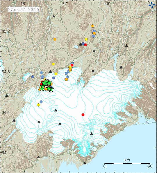
Largest earthquake on 27-October-2014 had the magnitude of 5,3 and happened in the south-east part of the caldera. Since it has been quiet in terms of earthquake activity. According to Icelandic Met Office this is normal and has happened before. Subsidence of the caldera happens without any earthquake activity most of the time. According to Icelandic Met Office and others (pdf file here), the caldera has now dropped some 40 meters. New cauldrons have been forming along the caldera rim and older ones (that I did not know about until today) have been getting deeper according to measurements from Friday (24-October-2014). The new and older cauldrons appear clearly on images that can be found here (text is in Icelandic). GPS data is showing minor inflation in the dyke that is currently erupting, suggesting that more magma is flowing into it then is erupting from it.
If any melt is happening in the caldera it is not appearing on the glacier yet. As for the water, it just goes down. Rock inside volcanoes leaks, a lot, so it is easy for the water to go into the crust. It doesn’t have to go anywhere else in small amounts that might be melting if the crust has warmed up enough to do so. Currently there are no evidence for that taking place, but with 850 meters of glacier on top of it is difficult to be sure. There are no other news about the eruption that I know of at the moment.
Donations: Please remember to donate or support my work if you buy from Amazon to due so trough the banners I have here. Thanks for the support.
Do you sense that pressure is increasing everywhere in the system?
Thanks again for the update and all your hard work doing it. So in your opinion the caldera could never be water tight as has been suggested and any melt would leak away through surrounding area. Also do you think there has been any magma intrusion around the rim and would this magma be coming from the same deep source as what is being erupted from the rift.
Volcano rock is never water proof (when it is young) and if the crust in the caldera has fractured a lot, any water is going to have good access into the rock.
Jon,
Sorry, but I’ll mention a pet issue of mine one more time then drop it.
IF you would bother the extra 10-20 seconds to put the link for the new article WITH your note about it–THEN many dozens of us would NOT have to scroll up to click to reach it.
I either lop off the part to the right of the last slash (“?p=…”, or click my bookmark of the blog address.
Assuming that there is or has been an eruption in the caldera, which is likely due to the obvious cauldrons, then possibly the effect will be like single storm clouds forming, thunderheads I mean.
They become their own micro climate, the warm air rushes up and cools then falls and yes at a very local level new air is drawn in, but for the most part you can circle the area with no ill effect until you come too close and are “sucked in” then away you go on what is I think one of the most exilerating rides you can get.
By the way I am describing sail plane flying or gliding.
The point is that although water is denser than air surely the physics are similar, so a heat source will create local depressions, if the heat increases then the effect remains local just speeds up.
Watch a pan of water boiling. Increase the pressure around the water and more heat is needed to boil it alla car cooling system, increase the heat 1600c and in a relatively short time you have an open eruption.
When you are sitting in a glider in the cloud and you can see hail stones the size of golf balls going up faster than you, you suddenly feel very small indeed!
Not likely because as long as there is still ice on top of that caldera there will be no steam. The water is not going to get much above freezing until the ice is gone but after that, all bets are off.
Just a couple of quick late evening (U.S. / CDT) thoughts.
* GPS Stuff
Back in late September, we would see GPS drops that were sharp and immediate (with respect to major quakes). We wouldn’t see drops with all quakes, but enough that, for the untrained eye, the two appear correlated.
Now, while the subsidence rate has slowed, the GPS curve looks ‘noisier’. Over time, the subsidence curve looks to be as smooth as before, but quakes do not seem to have the same immediate effect. They still look correlated to the GPS data, but with delays.
This is symptomatic of a system that has become more compliant (or ‘bouncier’ or ‘springier’) over time. One possible explanation is that there’s now a pool of water sitting on the caldera roof, under the glacier – where, before, it was more or less solid ice. The ice, being more rigid than a pool, allowed the ice pack to have a faster response to drops below. A pool acts like a buffer or filter.
Of course, much of the GPS noise is due to winter, but… still, we don’t see the same immediate drops as we did in September.
* Natural Convection
Speaking of pools of water sitting on the caldera roof, I’ve been thinking about the dynamics of a heater underneath a big block of ice. I think it’s absolutely reasonable that we have magma/lava turning ice into water into steam. The steam, in turn, condenses immediately back into water. The resulting hot water rises through the relatively cooler pool until it meets the ice pack, whereupon it cools and sinks.
Now, fluid dynamics are such that this will not be a uniform process across the whole of the caldera roof / icepack floor. Instead you’ll end up with convection cells. So, the underside of the icepack becomes pitted by the tops of these hot water plumes. If the pits are big enough, the top of the icepack sinks down and we have our cauldrons.
Which all the real volcano experts know already. So, I guess nothing new here. Still find it interesting, however, that my old fluid dynamics coursework is now coming in a little handy – providing at least the appearance of a rational explanation.
And this is exactly what I believe is happening. First of all, even solid ice loses about 9% of its volume when it melts. But glacial ice has a lot of embedded air (it is how they do atmospheric gas samples from glacial core samples to detect past CO2 content of the atmosphere, for example). So glacial ice loses more than 9% of its volume when it melts.
So yeah, I believe we have a rather typical subglacial pillow lava dome building event going on inside the caldera that is basically what these volcanoes do. Nothing at all out of the ordinary. The drop in the surface level of the ice is not, I believe, indicative of a drop in the underlying crust, it is simply a result of ice melting in the caldera from geothermal heat.
To make sense, thermal flux needs to be taken into account.
There is a difference in the behavior of a pot of water or of a block of ice depending on how much or what ratio of heat is being absorbed. Can the heat be totally absorbed? Is there convection? Is the boiling point ever reached and maintained? What is the temperature and pressure of the steam if there is any?
“This is symptomatic of a system that has become more compliant (or ‘bouncier’ or ‘springier’) over time. One possible explanation is that there’s now a pool of water sitting on the caldera roof, under the glacier – where, before, it was more or less solid ice. The ice, being more rigid than a pool, allowed the ice pack to have a faster response to drops below. A pool acts like a buffer or filter.”
Bzzz… water is incompressible, remember. The presence of water on its own is not sufficient; if you want a ‘bouncy’ effect there has to be gas involved too. Think Citroen hydropneumatic suspension, and their nitrogen-filled spheres…
Any eruptive activity is going to produce a lot of gas. Two things are going to happen during a pulse of magma erupting: 1: The newly erupted magma will take up space in the caldera. Since water does not compress, this will push the ice upward. The heat from the newly erupted magma (now lava) will cause ice to melt resulting in the level dropping again. 2: Any eruption will be accompanied by gas which will accumulate between the ice and the water until it finds an exit. This might also act to buoy the ice somewhat.
Yes, water is incompressible, but compressibility isn’t what I was thinking. Being a fluid, water carries load in a far different way than ice. So, different dynamics. You don’t need to bring gas in to explain a change in behavior, although… the presence of gas phase material would also do the trick.
Mike Ross, don’t remind me about those. Have you ever had to service those systems?
Of course you are right about not compressing water but as far as “bouncy” is concerned Pflueger may have a point, in as much that we see cauldrons on the surface so let’s assume that the ice is floating on the water, each earthquake shakes the ice, cracks form, heated water is forced into the gaps and you get a drop more ice melts, raises the level of the water and this lifts the ice cap, hence the bounce!!
As the ice is cracked whether by heat or earthquake you get a pressure drop which allows quicker melting of more ice, eventually you end up with breakthrough.
Having said all that (poorly) (I understand me), although there is 800mtrs of ice in the caldera,it is supported at the edges, so there should be less down force there than in the middle, which may point to the increased possibility of a side or flank breach.
Which could possibly lead to not only a huge flood, but if magma is lurking near the surface (of the caldera) the sudden release of pressure could have enough of a shock effect to trigger an eruption.
Maybe. Or maybe not. Laphroaig is taking effect must go peacefully to sleep and dream of toasting marshmallows in a spatter cone.
Goodnight all!!
Tried to service them? I own two CXs – one of them is one of the best CXs in existence, the thing is like new, only has 30,000 miles on it!
Actually very simple to service, once you know what you’re doing.
From EMSC
Region ICELAND
Magnitude 4.1
Date time 2014-10-28 04:54:54.4 UTC
Location 64.72 N ; 17.60 W
Depth 30 km
Distances 217 km E of Reykjavík, Iceland / pop: 113,906 / local time: 04:54:54.4 2014-10-28
110 km S of Akureyri / pop: 16,563 / local time: 04:54:00.0 2014-10-28
M 4.8 Earthquake, 120km W of Hofn, Iceland
23 minutes ago
Location: 81 miles (130 km) NNE of Vik, … Show more
Posted 4 minutes ago – U.S. Geological Survey
An earthquake with magnitude 4.8 occurred near Vik, Iceland at 04:54:52.50 UTC on Oct 28, 2014. (This event has been reviewed by a seismologist.)
Same earthquake, but this is USGS.
…at 7.7 kilometers deep (USGS)
I would be really interested in seeing atmospheric gas composition at the GPS sensor. If I were a research outfit, I would be looking to add gas sensors to that GPS unit. I have a feeling that we would see pulses of volcanic gases that correspond to pulses of changes in positions of those devices.
I would also be talking to the people who monitor the Cascade range volcanoes to deploy their “spider” devices at various points in and around the caldera.
On the “spider” monitoring devices: http://www.jpl.nasa.gov/news/news.php?release=2009-117
BTW are these “spiders” also resistant to snow storms and extremely cold temperatures? In the interior of Iceland, temperatures in the winter may go down to around -40°C.
The problem would be power. In very cold conditions the batteries would not last very long but there is some battery tech that could work fairly well at those temperatures assuming discharge of the battery will generate some heat. Military grade electronics will work down to those temperatures (I tested stuff down to -60C before and believe me, it’s hard getting components that work predictably at that temperature).
A small wind generator might help, like the ones they use for the buoys they place on Arctic ice to track drift. It really wouldn’t need a lot of power, probably less than a mobile phone.
The ring fractures are more lubricated by water and silicic acid silica gel. The EQs are deeper and from a different mechanism. Temperature gradient plug or caldera fracture and breakup hence close time occurrence and grouping.
I’d like to point out that when it is stated that the subglacial rim is 850 meters above the caldera floor, that is referring to the highest point on the caldera rim. Like any caldera, there are high points and lower points along the rim – it’s not like a perfect bowl. It looks to my eye as though the lowest breach point is only a couple hundred meters at most over the lowest part of the caldera floor.
That is very true and something I mentioned very early on. There may well be passes through the rim at much lower altitude and when the water reaches that level, we will likely see some runoff and that water is going to be, in my opinion, very toxic.
Here’s another one from EMSC
Magnitude mb 4.7
Region ICELAND
Date time 2014-10-28 06:05:02.5 UTC
Location 64.53 N ; 17.67 W
Depth 9 km
Distances 209 km E of Reykjavík, Iceland / pop: 113,906 / local time: 06:05:02.5 2014-10-28
130 km S of Akureyri / pop: 16,563 / local time: 06:05:00.0 2014-10-28
123 km W of Höfn, Iceland / pop: 1,695 / local time: 06:05:02.5 2014-10-28
Please can we stop this really unproductive and unrealistic discussion about subglacial eruptions that is clogging up the site?
For a better conceptual model of what could potentially happen if there is a subglacial eruption in the Bardarbunga caldera, the 1918 eruption of the Katla caldera under the Myrdalsjokull icecap is a good place to start:
http://earthice.hi.is/katla_eruption_1918
Many years ago, I studied the historical evidence for the impact of the glacier outburst flood from this eruption on the outlet tongue from which it emerged (the Kotlujokull), the outwash plain (the Myrdalssandur) and the coast, and interviewed one of the two chaps from Vik who is pictured standing on the iceberg.
The energy of the eruption was such that the column had NO difficulty breaking through hundreds of meters of overlying ice in the caldera and producing a substantial ashfall (see photo), as well as a jokulhlaup with a peak discharge exceeding the average flow of the Amazon.
Exactly. The table top volcanoes that formed under glaciers formed under glaciers that would have been many km deep.. A few hundred meters of cracked ice would be a small hurdle for a full eruption 🙂
Table top volcanoes (=tuyas) have reached over the ice caps, they are not wholly subglacial. So that the glaciers covering them, where not thousands of meters deep. The tuyas in Iceland, esp. in the north of the country have even be used to estimated the ice cover during the glacials, because of this speciality of their origin.
Wholly covered subglacial volcanoes are called hyaloclastic ridges or cones.
See eg. http://archive.today/20121202000905/http://www.raunvis.hi.is/~mtg/pdf/Jokull58_SPJ-MTG_subglac.pdf
To be clear for the many people here: the eruption when it starts under the ice it can have very different degrees of intensity.
Mild efusive eruptions might not be able to break the ice and then will form pillow lavas. This is the classic subglacial eruption we never see, except for the cauldrons manifested at the ice cap surface. Example is the eruption of Hamarinn in 2011 or Bardarbunga in 23rd August this year, both unconfirmed.
If eruption is a bit powerful it will break the ice and become mildy explosive, but not much. It doesn’t matter how thick the ice is. Example 1996 Gjálp eruption. And followinf that eruption, one month later, Bardarbunga caldera erupted for a couple of hours, explosively. Yes, most people do not know about this.
If eruption is very violent, it will break the ice in no time, and show up as an ash cloud, even through many hundred meters of ice. Example 2011 Grimsvotn.
And I believe we are likely seeing relatively mild pillow lava eruptions. We also have seen some small eruptions outside of the caldera that didn’t burn through the ice, either. This is more about geothermal heat than about any massive eruption.
My god, how many times have i read on here from the people who pooh pooh a big eruption, even though the iceland met office has it as two scenarios, ” it cant burn through all that ice blah blah blah”
Let’s apply some logic,nobody now living has witnessed a full scale caldera eruption,why?Calderas do not “go full on caldera eruption”very often,they stew for hundreds or thousands of years,the right combination of factors has to be present for a critical point to be reached.Now these systems can have “smaller” eruptions between great events and some of these are not that small.The scientists I assume play the odds and there are good odds of some sort of eruption,but very small odds of a massive eruption,as only 2 truly massive eruptions happened in the last 100 yrs,Novarupta and Pinatubo.
IngeB thanks for informing me they are different, I thought they where completely sub glacial 🙂
I was slightly over exaggerating with the depth, however the glaciers where deep.. Some of those over America where over 3km deep during the last ice age so I just assumed they would have been similarly deep in iceland at the time.
The build-up of tuyas is characterised by different stages. It starts out with subglacial stages producing pillow lavas and hyaloclastites (herein similar to submarine eruptions), but in the case of tuyas after some time (and perhaps some eruptions), there is an subaerial part with the production of lavas resp. subaerial tephras, see Herðubreið which even has a small pyroclastic cone on her top.
So, what happens to the CO2 released by the ice, and how much will ther be of it (per melted m3)?
Will it, presuming it remains a gas, be trapped between water and ice, or if the pressure is very high, be a liquid heavier than water?
Could be some very interesting reactions going on on top of that caldera. May be worth studying what happens if a hole is eventually blown through the glacier, potentially releasing huge amounts of CO2.
Is not the CO2 mixing up with the other gasses present in the volcano? Icelandic volcanoes actually are not famous for producing esp. high quanitities of CO2, it is more the sulfur compounds that represent a problem.
It depends on how much gas the magma contains,if for example the magma is a degassed rhyolite,it will just extrude non explosively and produce sub glacial domes.What could be happening is older magma(highly silicic?) that has been in place for centuries around the ring fault of the caldera has been heated by an influx of fresh basalt due to a rifting event,this magma is expanding and heating the ring fault,which is placing the caldera floor under extreme stress causing deformation and unlocking the ring faults?
Interesting graphic someone posted on another site,explains the area of subsidence being in the NE of the caldera. http://i.imgur.com/4oyDPs3.jpg
Very interesting. This also shows there is an open passage to the east for water to flow, if there was a sudden big scale melting.
Very interesting topographic map, thank you, JB.
I though don’t think that melt water would have such an easy passage to the east, as this is where the mass of Vatnajökull glacier is.
On the other hand, in the case of the Gjálp eruption, the water built tunnels for itselsf, run partially also over the surface of the glacier, whereas the biggest quanitity of the water was so forceful, that in the end, the tunnels below the outlet glacier Skeidarárjökull connected til the whole glacier was lifted up onto the mass of water which found its way down onto the Skeidarársandur.
See eg. Helgi Björnsson (2010): https://hal.inria.fr/file/index/docid/480676/filename/Bjornsson_resume_3_.pdf
Just for scale: This is the outlet glacier Skeiðarárjökull that went “swimming” in 1996. http://commons.wikimedia.org/wiki/File:Island_Vatnaj%C3%B6kull_07.JPG?uselang=de
In that chart ,if we were to consider the darker red areas of the caldera (rim) are mainly composed of extruded magma,then this would give us a clue to the areas of greatest historic magma extrusion?This so happens to be on the N side of the caldera and the quake pattern has been following this “horseshoe” shaped rim,with particular emphasis on that northern “spur”.Also the depressions in the area of the caldera that is currently subsiding,are those maars,caused by hydrothermal activity at a long existing hot spot on the caldera floor?
Would not the caldera have to have been without ice to produce maars? You mean hydromagmatic / hydrophreatic explosions like the one on the Japanese volcano Ontake or at White Island, NZ?
So that this would have had to be in a time when the climate was much warmer than today? I think that was last so at about 3 mill. years ago. The volcanologist Prof. Schmincke said that the life time of a big volcano would be between around 100.000 and 1 million years.
We are also talking here about the highest mountains in Iceland, and there were normally glaciers covering these mountains in this region even during the times of rather warm interglacials etc.
Alaskan maar? http://m.livescience.com/32033-biggest-maars-on-earth.html
Under a glacier?
But you can find maars in the icefree north of Iceland, they are often called Víti (hell).
On the Víti within the Krafla caldera: https://commons.wikimedia.org/wiki/V%C3%ADti_%28Krafla%29?uselang=de
The Vítí in the Askja caldera: https://commons.wikimedia.org/wiki/File:Viti_geothermal_lake_at_Askja.jpg?uselang=de
And if these look a bit underdeveloped to you, we also have a rather impressive explosion crater near the lake Mývatn: https://commons.wikimedia.org/wiki/Hverfjall This crater has a diameter of 1,8 km.
BTW: Do not maars and explosion craters have a dyke system called diatremes, very different from calderas? http://geolines.gli.cas.cz/fileadmin/volumes/volume15/G15-072.pdf
Maybe there was no ice in that area after a massive caldera forming event blasted it away >10000 years ago?There are 3 depressions on that chart,which they call calderas,so my mistake.
Some giggling going on: Google translates the cauldrons sometimes as “calderas”, really rather misleading in our case.
Alexandra Witze @alexwitze · 15 min Há 15 minutos
35,000 tons of SO2/day from #Holuhraun is an order of magnitude less than #Laki 1783 @subglacial
I wonder who was doing the accurate scientific gas measurement in 1783?
I believe that an Ice core lab in Denver collected ice cores from Greenland that clearly showed the ash layers that were erupted from Laki and they could work out many measurements based on their finds.
But since it’s not direct and comparative measurement the word “estimated” should be used,but I guess it was just twitter…
I think this is the whole text from Alex Witze:
“Gas spewing Icelandic volcano stuns scientists”
http://www.nature.com/news/gas-spewing-icelandic-volcano-stuns-scientists-1.16234?WT.mc_id=TWT_NatureNews
And at Twitter she linked this study abot Laki:
http://onlinelibrary.wiley.com/doi/10.1029/2001JD002042/full
Thanks for the links. Second article in particular looks very interesting for my particular interests 🙂 Looking forward to reading it all.
University of Iceland has published a photo of a new graben forming.
https://twitter.com/uni_iceland/status/508150598278332416/photo/1
The photo is dated 6 September.
And so it is. Thanks for pointing that out. I didn’t check the date and assumed it was a NEW tweet. Apparently it was not.
Can anyone tell me if overflights of the Bardabunga are taking place? If so, does this give any indication of the drop of the caldera?
Touristic sightseeing flights might fly near it. You wouldn’t see anything from such a flight, except for cauldrons.
@Colin
I believe this is the info you are looking for. These are the results of the last overflight on the 24th.
http://jardvis.hi.is/maelingar_siginu_i_bardarbungu_med_flugvel_isavia_tf_fms_24_oktober_2014
thanks very much.
I still well viewed last 24 hours, noting that security does not open melt water sits by the quakes paid on location up to 100 meters 100%. See today’s quake rapport
14:26.41 -17.28 64.74 0.5km 1.3
13:01.50 -17.44 64.61 0.7km 4.6
09:39.51 -17.38 64.67 0.4km 0.7
04:37.44 -17.35 64.71 0.1km 1.0
04:07.58 -17.35 64.61 0.1km 1.6
Suppose 400 meters meltwater can be in that space be? No earthquakes
New video!
http://icelandreview.com/news/2014/10/28/eruption-journey-video-roundtrip-hell-premiered
Another article mentions the SO2 pollution: http://icelandreview.com/news/2014/10/28/tourists-concerned-about-pollution-glacial-lagoon
“Icelandic Director of Health Haraldur Briem stated on ruv.is that continued exposure to SO2 has no long-term effect on human health, referencing a study of SO2 pollution carried out among inhabitants in Japan where an eruption has lasted seven years.” – Hm, in this information for Hawaai, it reads: ” The long-term health effects of vog are unknown.”
http://ltgov.hawaii.gov/emergency-information/important-information-about-vog/health-effects/
And this doctor of medecine says also that there are just some papers about short time influence on people (over some years). She intends to participate in a long time research project on this matter. http://www.visir.is/rannsoknir-a-gosinu-serstakt-taekifaeri/article/2014141019788
If this is the paper the Icelandic Director of Health was referring to? http://oem.bmj.com/content/65/10/701.short
Mafl, good video all the lava escapes from just one opening at the side of the vent, into three separate flows.
True Icelander there on the mountain in the snow wearing flip flops n shorts, I think I saw him sweating at one point
IngeB had a question about the “spider” monitors and their ability to withstand extreme temperatures. Professor WenZan Song, http://school.eecs.wsu.edu/node/629 is the person behind this, he would be the person to ask.
Question for Irpsit:
You wrote “And following that eruption, one month later, Bardarbunga caldera erupted for a couple of hours, explosively. Yes, most people do not know about this.”
How do we know this? From the seismometer graphs? And if so, which ones? Could you please point me to some links? Thank you.
Randall
It seems this eruption is unconfirmed, it is mentioned as such in GVP ‘s eruption history of Bárdarbunga. http://www.volcano.si.edu/volcano.cfm?vn=373030
And in the comprehensive paper on the Gjálp eruption, there is mentioned (p. 7 of the pdf), that there were discovered some new ice cauldrons in the southeastern part of the caldera. This could mean small subglacial eruptions – or not. https://notendur.hi.is/oi/Pdf%20reprint%20library/1996%20Gjalp%20eruption.pdf
Is this what you are referring to?
“A small eruption started in Bardarbunga around 1300 hrs on November 6th. The eruption lasted for about 20 to 30 min. According to seismograms at the Meteological office, the eruption was initiated by some intrusive activity. The intrusive activity is based on recorded eruption tremor picked up by on of the seismometers. Eruption column reached about 4 km in to the air. Relation between pressure decrease due to the flooding have been suggested as the main cause of the eruption. ”
Bottom of this page
http://earthice.hi.is/gjalp_eruption_vatnajokull_309_1310_1996
I think this is a key phrase from the paper “The local stress field of Brarbunga may be the main cause for the shape of the fissure. Either loading from the volcanic edifice or high pressure in a magma chamber at Brarbunga at the start of the eruption would favor radial fissures if the least principal stress is horizontal and tangent to concentric circles around the volcano. This local stress field would interfere with the regional field
that generally favors dyke formation along the dominant strike of roughly N40 E. The sum of the two stress fields could cause the fissure to curve towards Brarbunga, as
observed”
As we watched the quakes progress at the end of August, it was easy to see a repeating pattern from 1996, however the new component of tectonic rifting created a new fissure system which surfaced at Holuhraun, if I am understanding this correctly.
While some has posited that Bardabunga’s magma chambers are being drained, I am not so sure, the new increase in SO2 gas seems to suggest deeper magma influx. If the cauldrons continue to deepen, I think we could be in for a mild phreatic eruption as Irpsit has suggested.
I admit being a bit concerned about the vertical movement on the GPS at Bardarbunga, I believe that it is telling us something, but what? The vertical oscillation trend on this instrument has been slowly increasing.
Randall
The high SO2 levels always suggested fresh magma. A rising of level could be either more lava being erupted, a higher concentration, or both. Higher concentration would only mean that the lava is coming from a less exposed, possibly more interior source.
If there’s twice as much lava at Holuhran than the volume of the subsidence, then at least that much, and probably much more, must come from other sources.
However, if the subsidence is only related to the ice over the caldera and not to the underlying rock then this logic fails.
In either case, increasing volume and hydraulic pressure is roughly measured by the overall spread of the earthquakes in the surrounding fissures as well as by the volume and force of the eruption.
Yes, the eruption that happened in the caldera of Bardarbunga was on 6 November 1996, as shown in the link that Kolla posted.
Everyone that day was focused in the glacial flood that just started. And the flood relieving pressure at the caldera probably triggered that minor explosive eruption.
SteveG, I don’t think it’s possible that subsidence is caused by ice alone. Ice quakes could never be causing a series of M5 events. this sort of magnitude must in all likelihood be the caldera collapse, it can’t even be just a minor subglacial eruption. It’s a high amount of energy released everyday.
It could be also a very large of magma on the move, at the caldera, but less likely. If it would be this scenario, then magma coming up should maybe trigger some visible inflation, and cause geothermal heat, which could explain the ice sinking, but not the sinking syncronized right at same time with M5 quakes. Ergo it must be caldera subsidience.
It has been asked elsewhere whether the subsidence and the mag 5 quakes are connected, or physically causal.
But this is not the right question to ask because it narrows the scope to whatever is being discussed at the moment. A better way is to go back to the geological setting, to the significant fundamental motivational forces that are essentially inexhaustible, and the relative equilibrium between these that result in the current geology.
To my very limited knowledge, that would be continuous but irregular tectonic rifting, the magma plume and its off-shoots, other geologic movements, and, perhaps, tidal forces, both from the moon and the sun.
Tidal forces pump the terrain and the magma four times a day up-down and sideways. This might be the cause of the quasi-regularity of tremors and quakes. A test for this would be to look at the chart at new moons for increased activity.
Likely, both the quakes on the north rim and the subsidence are caused by deeper factors, which are in turn caused by imbalance in the fundamental factors.
Ehm .. the tidal forces are neglectable. Just a little reminder on that: http://www.wired.com/2012/05/on-earthquakes-eruptions-and-the-moon-eruptions-revisited/
That’s a gorgeous picture of the Moon. Lovely terrain.
The popular notion misses the subtleties. Gravitational interaction is strong enough to stretch the Earth considerably, and Iceland is floating on a liquid surface, so, as a whole, Iceland moves up and down with the tides.
The rocks are another ‘story’. The total tidal force on land is negligible for almost all purposes. But fractured mountain-sized blocks might be shifted a millimeter or so (according to a calculation done on the back of a paper napkin) 4 times a day. I figure that the periodicity adds up over time to small shifting.
Earth tide refers to this 1998 (obsolete) article:
http://hvo.wr.usgs.gov/volcanowatch/archive/1998/98_05_28.html
Scientists have found no correlation between [earth] tides and earthquakes. Correlations between the tides and eruptions, however, have been identified.
without a needed further reference to where they identified anything.
Then there’s this rather speculative 2007 study on shallow flank eruptions:
http://onlinelibrary.wiley.com/doi/10.1029/2006GL028190/abstract;jsessionid=FCE859EA66C241732EE886943AD34E48.f03t01
For some reason your comment got eaten by the anti-spam system. I have recovered your comment. Sorry for the delay.
Thanks, Jon ! I did want to add closure to the topic.
I messed up the HTML right at the top, though. No ending bracket?
I fixed the html code for you. 🙂
THANKS THANKS THANKS Y’ALL for the great links and solid info.
I love your post, Da Xin!
Now I can keep posting things just above yours and get automatic thanks. ;D
Sorry guys, mother earth has put one over on you all –
http://snag.gy/GZF4m.jpg
LOLOLOLOL
Cute.
Thx.
Absolutely brilliant . LOL 🙂
:LOL:
so funny! 🙂
🙂
Magnitude mb 4.7
Region ICELAND
Date time 2014-10-29 05:23:44.5 UTC
Location 63.95 N ; 19.06 W
Depth 60 km
EMSC
It seems the Mid Atlantic Ridge is quite busy,
http://earthquaketrack.com/r/northern-mid-atlantic-ridge/recent
Mila cam 2 is looking amazing this morning. Camera is shaking like crazy at times.
Perhaps some lokal storm. During weather like this, with snow showers (in Icelandic “éljagangur”), there can be a snow storm at one location and at 500 m distance from the place you have just sunshine and no wind at all.
And this explains why the cameras may be shaking and on the next vedur station, nothing is to be seen about a storm, like eg. here: http://www.vegagerdin.is/ferdaupplysingar/faerd-og-vedur/sudausturland/linurit/st189.html This was just a bit wind there.
Please say someone else is watching cam 2 this morning? would love to know if this was normal as haven’t had a decent view like this for a while.
Yes, took a look this morning and to me seemed stronger than it has done of late! Seemed in a bit of a furious mood but very beautiful to look at.
Glad it was just me who thought it looked quite Furiou . I got some lovely screen shots of the fountains i have been mesmerised for a good hour now.
I spend ages captivated by it too, especially at sunset! 🙂
Is that a helicopter on Mila2 .
I thought it was a black mark on my laptop but it only shows on the Mila2 webcam?
I would guess a stain on the glass that protects the camera.
This spot has been on cam 2 for ages.
Either dirt on the lens or dead pixels in the sensor
The fact that this unidentified flying object is there since weeks and that it does not move at all tells me that it uses a kind of technology which is not from earth. I am pretty sure that it uses alien technology. No surprise that this event attracts also scientists from abroad. From very abroad…
Sorry, no UFO from outer space in Iceland.
That et-tech would explain very well the M4-5 EQ’s and why BB refuses to erupt. It’s almost single-handedly surpressed by a self appointed guardian of the status quo.
Hi everyone, been watching this blog for a couple of months now and have found it very interesting and informative, thanks for all the facts and figures.
A quick question, don’t know if anyone will know the answer, with all the mag 5+ quakes which there has been a lot since this has started what is the most 5+ quakes that have occurred in one place in this time period are we seeing something that has never been recorded in modern history.
Thanks all
Exceptionally clear view on Mila cam 1.
Amazing how the plume from the vent and the steam from lava/river-contact are merging.
… well rather “meeting” than “merging” …
Jon, your estimate of 45 m subsidence at Bardarbunga is closing in approximately 13 days away max.
I know it’s not set in stone but from all the ongoing activity, is it still the level of drop that your estimate of point of no return remains have you reworked your figures?
Heh, I was thinking about that 45m figure also with all the hammering going on.
Hmmm, took me a while to get my perspective, I haven’t seen the Mila cams with anything visible during the daylight for a couple of weeks now. Is that still the steam plume on the left of cam1 that is flowing to the right? It has gotten rather large.
It is stream from where the lava meets the river.
btw: the M&T cams are back … clear view at this evening.
http://vefmyndavelar.mogt.is/
http://en.vedur.is/earthquakes-and-volcanism/earthquakes/vatnajokull/
Copyright of IMO
That’s the first +3 magnitude EQ outside of usual area that I can remember, correct me if wrong. Positioned between Bardarbunga and Tung.
Cause and effect if the ring faulting at Bardarbunga’s NE flank has passed a certain level of subsidence it stands to reason more larger EQ’s will show further out. This in effect is one sign that the activity of the upper crust is expanding. More EQs will confirm if true
Jon:
Have you heard if there is any evidence of lava-tubes/ pyro-ducts in the Holuhraun flow ??
Nice pictures of the “cauldrons” that have developed around the BB caldera ringfault posted by Rei yesterday:
http://www.dailykos.com/blog/Rei
Big lava fountains now in cam2!
Huge now!
Strombolian activity?If so this is counter intuitive ,going from relatively extrusion to more explosive.
has anyone any idea of the height of the lava at the moment? – looks amazing.
http://geology.com/volcanoes/types-of-volcanic-eruptions/strombolian-eruption.jpg
They are the biggest fountains I have seen as of yet. It as quiet earlier on today
It is getting going.
are those big lava fountains, or just fumes/smoke lit at sunset ??
Let’s wait until it get’s darker…
Better to not use the term “smoke”when talking about volcanoes,the experts dislike that lol.
Sorry, but that is only (red lighted) steam! It’s an optical illusion due to the beginning of darkness.
You are wrong! Huge lava fountains now+smoke.
OK, I have to clean my glasses … but look here and simply scroll with the mouse-wheel http://brunnur.vedur.is/myndir/webcam/2014/10/29/webcam_mogt_kverkfjoll.html
I bet that on one of the next pics (18:00 …) the hole area will explode!
18:30 … nothing happened … hmm
Angry Bunga this evening on the webcam…there must be huge pressure going on.
With this huge lava fountains it’s possible we are enter in a new phase? Thank’s!
see my comment above … nothing has changed!
If that should be “huge lava fountains” then there must be hugh clouds on MILA cam1 … they aren’t.
Just opened up the cams, and wow, big fountains going on today. And a little more push of the lava on the N tip of the flow. Steaming pretty good.
And now at the moment they have reduced in size some. And yes, the reflecting of light off the steam can make it look bigger, but you can see, if you watch carefully, the fountains rising up pretty high at times. It just doesn’t look like it is keeping a steady height. Probably just pulses.
While it is still light can someone look at Mila Cam1
There has been much ‘steam’ I think coming from the end of the lava flow this afternoon – more than I have seen before.
Could the lava have blocked most of the river flow now so much water is forming in a lake or pouring over the hot lava to cause so much ‘steam’??
http://www.livefromiceland.is/webcams/bardarbunga/
Here Gill. Check these cams.
http://mynd1.mogt.is/mobile1/images/right/m141029171002345.jpg
From here.
http://vefmyndavelar.mogt.is/
Thank you Brian 🙂 It is then steam in the cold air – quite spectacular to see.
You can see the source of the stream here (last pic)
http://vefmyndavelar.mogt.is/
The steam cloud is is as huge today as the plume from the vent used to be the other day. Earlier it looked like the plume and the steam were merging, but as the clouds are moving from the left to the right (e.g. to the north), all that steam comes from the lava/stream interaction. The plume goes off the cam to the right. Truely impressive steaming (maybe partly due to low temperatures?)
Check out the M&T cams for a better idea if there is any change
Thank you very much Mark, Brian and Enno – yes I have that saved to look at too now and I see the Kverkfjoll cam is clear again too. Good to see all angles for reference. Thank you for your time.
I wonder is the magma for this eruption interacting with some more evolved magma near it’s source?Hence the increasing gas levels and tendency to more energetic output?
Some good pictures of the ‘steam’ here too (and eruption) – hmmm now I am not so sure it is not just cold evening air causing it?
http://vefmyndavelar.mogt.is
This article could have relevance to this event. http://www.ibtimes.com/magma-dormant-oregon-volcano-mount-hood-peanut-butter-refrigerator-study-could-help-predict-future
Is the current activity like this? http://www.youtube.com/watch?v=Nfsbz_hleRs
I think Yasur is too small – though it produces also a lot of sulfur. This in my opinion is more comparable to Etna’s smaller strombolian eruptions, like: http://www.youtube.com/watch?v=JfA0-FvOZIc
And the change from lava lake eruption to lava fountains would mean a more gaseous magma and more pressure? Which could perhaps mean a bigger portion of felsic magma in the mix? (from: http://www.geology.sdsu.edu/how_volcanoes_work/Controls.html ) Would be interesting to know, how the gas mixture escaping the vent has changed. Would eg. less SO2 and more CO2 be connected to a higher intensity in the eruption and a higher explosivity?
Higher CO2 would be from a fresher magma source?The magma could be more viscous due to higher silica content,would that be at odds with a high amount of CO2,unless this is a fresh mix?
I thought, higher SO2 would perhaps mean more mantle material, ie. a deeper source, whereas higher CO2 (bubbles) content, could indicate a higher percentage of felsic magma?
Gasses as a whole drive eruptions. Which gases drive which sort of eruptions? Does it depend on the actual mixture? In which way?
This description of an experiment answers clearly some of my questions: http://www.dinojim.com/PDFs/Volcanic_eruption_using_a_soda_bottle.pdf
CO2 is exsolved deeper in the crust than H2O. hal.archives-ouvertes.fr/docs/00/82/81/51/PDF/CTMP-D-Rev.pdf
There is a high cloud from the fissure behind the other one:
http://abload.de/img/14-10-29-019-bardaiyuoz.jpg
Cam 2
http://abload.de/img/14-10-29-020-bardadsag5.jpg
Looks like they posted 4 new GPS sites. Don’t know there exact location, but more info around the area is good. MOFC, DYNG, RIFC, and ALFD.
http://strokkur.raunvis.hi.is/gps/#VATN
RIFC?
http://en.ja.is/kort/?x=620867&y=495523&z=5&type=aerial&q=Rifnihnj%C3%BAkur
DYNG?
http://en.ja.is/kort/?x=643310&y=520670&z=5&type=map&q=%20Dyngja
RIFC is right, but DYNG is probably around Askja somewhere.
Yes, DYNG is at Askja. See: http://gps.vedur.is/mapGPS.php