
This is the Friday update for Bárðarbunga volcano eruption.
During the past 48 hours total (when this is written) of 69 earthquakes with magnitude of larger than 3,0 have happened in Bárðarbunga volcano. Total number of earthquakes in that same time period is 286 earthquakes (when this is written). Since yesterday it appears that earthquake activity is increasing in Bárðarbunga volcano at the moment, there is minor fluctuation in activity every few hours. I do not know why that is happening.
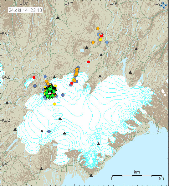
Earthquake activity in Bárðarbunga volcano. Green stars are earthquakes larger than magnitude 3,0. Copyright of this image belongs to Icelandic Met Office.
Most of the earthquake activity is taking place in North-east part of Bárðarbunga volcano caldera rim. Few to no earthquakes are happening in the centre of the caldera. Currently the caldera continues to lower around 30 – 40cm/day according to latest news from Icelandic Met Office. Far as I know the eruption in Holuhraun continues at the same rate as yesterday with no major change taking place. Some minor earthquake activity has been taking place along the dyke for the past 48 hours. Other then this I don’t have heard any other news about current status. I am currently looking into few details about what might be happening, but I am as always waiting to see what nature does next.
Added: I forgot to mention that Holuhraun lava field is now 63 square kilometres in size. It doesn’t grow in size today as fast as it used to do. It might however be adding volume rather then size at the moment, with occasional break in the lava rim allowing it to expand slowly.
Donations: Please remember to support my work by donating or by using Amazon to shop. Please just choose your region in Amazon Webstore site if I don’t have banner from you area up. Thanks for the support.
Other: Next week I move to a different schedule since current phase is not changing a lot between days. This means that updates are going to be on following days. Monday, Wednesday, Friday. Unless there is something new happening then I am going to update right away with newest information. I never know what is going to happen so I don’t keep tight schedule on updates.
Article updated at 22:51 UTC.
(Same earthquake as above but from emsc)
Magnitude mb 4.8
Region ICELAND
Date time 2014-10-27 01:05:18.5 UTC
Location 64.50 N ; 18.12 W
Depth 10 km
Distances 187 km E of Reykjavík, Iceland / pop: 113,906 / local time: 01:05:18.5 2014-10-27
132 km S of Akureyri / pop: 16,563 / local time: 01:05:00.0 2014-10-27
Da Xin is your question in regards to the natural state of the earths crust?
Factors of gravity, fluid dynamics, the exact placement of where temperatures balance between mantle and upper crust to allow solidification.
If the magma is at higher temps (current idea) and Icelands on a hot spot then current eruption is result
One curiosity to me was just the issue of Iceland having a thicker crust than . . . . ??? . . . earth’s average? . . . than the rest of the Mid Atlantic Ridge ???
AND
yet, newer lava is thought to push older lava deeper??? It just seemed to me that a thicker crust would make newer lava pushing older lava deeper . . . more difficult, less likely. Maybe that’s simply an ignorant idea on my part.
If I imagined a swamp . . . mud 12 deep vs 100’s of feet deep . . . I think I’d have a harder time pushing a bolder 100’s of feet deep vs 12 feet deep. Though I realize that if the bolder is seriously more dense than the mud, then lots of shaking would eventually get it 100’s of feet deep.
Thanks for your kind reply. Is that the question you were referring to? If not, let me know which question and I’ll try and give a better reply.
I think to your first question about the thickness of the crust in Iceland: That it is up to around 40 km thick would be explained by the presence of a hot spot. http://www.norvol.hi.is/~thora/summer2003/notes/OG_notes.pdf and http://www.geotop.ca/pdf/darbyshireF/Darbyshire_et_al_EPSL_2000.pdf As there an extreme volume of material is welling up from the mantle. Because of that it is also part of an LIP, the North Atlantic LIP. It is not as with other parts of the Mid-Atlantic Ridge “just” the rift mechanism or decompression melt.
Also there is a mechanism at work, which we have to imagine like sort of two conveyor belts placed one in front of the other and working in opposite directions. The material appears between them and with time is pushed to the sides. This explains why the oldest rocks of Iceland are the farthest from the now active rift zones, ie. the rocks in the NW and SE of the country.
If you are referring to my question about SO2 . . . I was curious whether greater SO2 would have any mechanical influences on the magma and adjacent soils vs low SO2 concentrations in the magma . . . and/or . . . greater differences in eruptive qualities, traits of the magma between that with higher concentrations vs that with lower concentrations.
Do not higher gas concentrations always have an influence on explosivity of the magma – in both directions, magma which had the possiblity to degas a lot, is perhaps more fluid, whereas magma which couldn’t degas before eruption would contain more bubbles and this would increase the probablility of a very explosive eruption? And do not gases, their quantity and their type say something about the chemical and petrological qualities of the magma?
Would be really interesting to see gas analysis from Holuhraun or the newest petrological analysis of the lava.
But also esp. gas analysis – if there are – from possible fumaroles on the caldera rim…
I don’t know if this has been posted yet. A bit more information on volcanic gases (USGS): http://volcanoes.usgs.gov/hazards/gas/index.php
As to the heightened gas content – could there be magma mixing going on somewhere under Bárðarbunga?
Either that, or the water produced by the melting caldera glacier is going somewhere. Hawaiian volcanos, just magma, no steam. Iceland, same magma but large volumes of steam.
And the generally very high gas content and degassing be due to high H2O content within the magma?
It seems that unless atmospheric conditions are the sole cause of the gas levels,that any substantial increase in gas from the eruption,without a corresponding increase in lava output,would indicate gas is coming from another source of magma?
Or just that the wind speeds have dropped. Bring back the gales!
I read somewhere that the gas output at the eruption site was elevated in comparison to before a week or so.
I am not sure if an inversion weather situation only would be able to worsen the gas situation in such a degree.
High sulfur mainly comes from depth. In an eruption, SO2 is produced in a flaming fiery reaction when hot lava comes in physical contact with atmospheric oxygen. However, most of the sulfur should still remain locked in the erupted lava in various forms. When old rocks are remelted, then the remaining sulfur is again burned to some degree. But the original deep alkali upwelling ought to expected to have the highest native proportion.
Steady high winds rapidly drive the gas out to sea. Windless conditions and temperature inversions permit the gas to accumulate to greater concentrations around the eruption.
@SteveG. Thank you, this is interesting.
So you would imply that most of the magma is now originating from the mantle and not from Bárdarbunga? And do you think there is a high alkali content in this magma at Holuhraun? This would be a bit astonishing, because only some volcanoes to the south of Vatnajökull are in Iceland conneccted with alkali basalts, ie. Eyjafjallajökull and the Westman Islands, whereas the rest of Iceland consists normally of tholeiitic basalt.
Thanks for the link. I didn’t realize that the expansion was so massively enormous in atmospheric pressures compared to deep in the crust. Logical, I just hadn’t thought about it.
More than 60 new pictures from Roon Grapenthin at fieldwork:
http://www.grapenthin.org/pictures/thumb.php?album=2014_askja_holuhraun
Great pics, thanks for sharing, really appreciate the fieldwork, who is the sponsor?
And you can follow his updates on twitter.
https://twitter.com/rngrp
Really interesting and fine pictures, thank you for sharing. 🙂
That album though says last updated 24 August – I’m a little confused.
Yes, I saw that, but the photos are clearly not from the August.
Great pics. Thanks.
Are there any new images of the extent of the lava flow into the river?
Increased geothermal heating at Bardarbunga in latest bulletin. http://avd.is/en/wp-content/uploads/2014/09/Factsheet_Bardarbunga_20141027.pdf
This is behaving like a typical resurgent caldera?
I mixed up the blogs, but have now asked on VC what would count against it. Someone will set me straight, I am sure.
VC?Do you mean volcano cafe?I have looked on there out of interest and it was mostly jokes in the comments,but they have” interesting”articles.
You mean like Yellowstone? https://en.wikipedia.org/wiki/Resurgent_dome
The cauldron formation is a bad news. It means that at that spot in the caldera magma has now reached the depth of 1 – 2 km and warmed up the nearby rock in the process. Creating this high powered hydrothermal area. I am not sure if there might have been a minor eruption at that location, that is a possibility since such activity has been seen in Bárðarbunga area for the past two months.
The glacier in this part of the caldera is I think 200 – 300 meters thick. It might be shallower at this location.
Maybe this indicates the caldera has “reactivated” and will be a more active system into the future,without necessarily a large explosive eruption,just a more active system that needs to be watched?
I don’t know if it possible to see something on this picture.
http://abload.de/img/14-10-24-barda-satqej7g.jpg
It is a cutting from this picture:
https://twitter.com/edwinbul/status/525731035934625792
Could it be the “hole” at the east side of BB?
)Mafl the subsidence is obvious in the glacier in that picture.
Assuming such is the case . . . at present rates of increased heating, do you have any experienced perspective guesses about when it might break through the glacier in an obvious visible eruption?
Da Xin this is heat related the magma,or the bulk of it would be still some way below the surface,there is not any large increase in tremor to indicate it is moving closer to the surface.Maybe this is an old magma body being heated up by basalt intrusion,so currently only causing heating of the caldera and ice melt ,with subsequent hydrothermal activity?
@Mafl: thanks for the link, I think the picture does show 3 cauldrons around the edge of the caldera; but its’s deceptive due to the viewing angle (roughly from Sout West). The cauldrons look like bumps, and the whole of Bardarbungu looks like a big hole.
@Mafl and @JB: if you can, copy the image into an image manipulating program (I use Irfanview) , and then rotate the image 180 degrees. The viewing angle is now from roughly North East. The whole mountain is a flattish bulge, with the dark area the outer wall of the caldera. The three little dents are the cauldrons. You cannot see the 40m subsidence in the 10km wide top (of course), and the rough looking area is lava flows etc. not covered by glacier.
All that is my interpretation of the image; your may differ.
Jon have you seen the pictures in this link ,the cauldron are obvious as well as the central subsidence in the glacier? http://jardvis.hi.is/maelingar_siginu_i_bardarbungu_med_flugvel_isavia_tf_fms_24_oktober_2014
Thanks Peter W.!
It’s like an optical illusion. What seems to be a “hole” is now a “hill” or “dent”. But isn’t a “cauldron” a little “valley”?
Sorry for my bad english…I don’t now the right words…hope you understand.
…and thanks JB for the links! In the picture are the two western “cauldrons” which google made to “geothermal boilers”…
The IMO statement was , “Geothermal (the stored energy of the earth) heat is increasing in Bardarbunga.”. You caught on to this Jon as you are using the term hydrothermal (the energy in the heated water) which is entirely different, and is the result of the geothermal increase. You are right to be mentioning that it is not a good sign.
In this link which JP set in here (University of Iceland), Magnús Tumi Gudmundsson says, that the cauldrons (“Kessel” in German, Mafl 🙂 ), have been there also before this event began in August. But that they have been deepening considerably. The cauldron in the southeastern part has deepened by about 20-25 m (I think that should be m), the western cauldron by around 12 m. They think the reason for that is more geothermal heatwhich they think is not surprising, because the movements at the ring faults have made it possible that water can enter the ring fault system.
Yes, Inge, i know, i was irritated by the “dent” from Peter W. … 🙂
Extreme example and probably not the best example.
@SteveG re Yellowstone
Monday
27.10.2014 13:10:04 64.673 -17.517 8.8 km 3.7 99.0 3.7 km N of Bárðarbunga
Monday
27.10.2014 13:06:15 64.683 -17.435 8.1 km 3.0 99.0 6.4 km NE of Bárðarbunga
Monday
27.10.2014 13:04:32 64.687 -17.483 9.2 km 4.0 99.0 5.6 km NNE of Bárðarbunga
THANKS, crosspatch.
Heavier I can understand. LOL.
Though . . . come to think of it . . . when I’ve tried moving a granite bolder . . . it sure felt heavier than a basalt rock of similar size with lots of bubbles in it. LOL.
I can face it that I’m just an ignorant shrink trying to understand complex geology.
amazing view on MILA cam 2 at trhe moment!
Evening all
Jon you say that magma has moved to within 1 to 2 km depth, do you think that an eruption from Bards is more than likely to start sooner rather than later considering the increase in the stronger seismic activity.
Pretty decent graphic here. Shows that any subglacial eruption INSIDE the caldera would cause the water to be trapped inside the caldera and produce no visible runoff.
https://twitter.com/hartza66/status/526784373291778048/photo/1
This very much depends on the kind of the eruption, I think.
If you have an explosive one, the water could very well be evaporised partially and the rest pressed over the rim, also the about 150- 200 m of ice over the caldera rim would melt and cause a considerable glacier run. An renowned Icelandic glaciologist, Henri Björnsson, said in an interview some time ago, that esp. the steepness of the caldera rim to the west must be a cause for concern.
And then, there is also a possibility of a breaching to the west … Which hopefully won’t come to pass …
That is an interesting question,what is the stability of the edifice like with a weakened ice cap,is the ice holding these steep sides up.?
I don’t see any way for much of an explosive eruption to occur. It’s under 800 meters of ice and water. Eruptions aren’t generally explosive at that depth. Water can not get to high enough temperature to flash to steam at that depth because it will convect upward long before it gets to high enough temperature. A good example would be the Loihi Seamount in the ocean off the coast of the island of Hawaii. It is at about the same depth and the type of magma it erupts is quite similar. It often erupts completely unnoticed. There is no surface evidence of any eruption. It is just too deep.
Subglacial eruptions of HUGE amounts of maga are rather common in the geological history of Iceland. It is how the table mountains were made. Generally they are called Tuya.
http://en.wikipedia.org/wiki/Tuya
I agree with you partially, but you’re missing one critical factor – the constraints of the caldera walls and how pressure diffuses once it’s released into a completely open space.
As you mentioned, many large eruptions never reach the surface at deep depths beneath the ocean, but aside from the depth itself, there isn’t much else similar.
When an eruption occurs under water, the pressure diffuses extremely quick beneath the water since there is almost a limitless supply of water and space for the pressure to spread out into.
For bardarbunga, despite there being a glacier above it, there is nowhere inside the caldera for that pressure to escape laterally until an eruption breaks through to the surface. So you either get an eruption that isn’t large enough to break through to the surface (which essentially would mimic a failed eruption from a dike emplacement), or you get a powerful explosive eruption that can break through to the surface. The glacier is more or less like adding a sticker to the top of the cork on a wine bottle, it may help hold the pressure in slightly more, but once that pressure does escape, there is only one easy way for it to go, and that’s straight through the top.
This is also ignoring the potential explosive component adding water to fresh magma adds.
As for the subglacial tuyas and pillow lavas, most of these occur in iceland away from the central volcanoes, don’t represent larger eruptions, and are often formed from what would be an otherwise effusive eruption. It just depends on the magnitude of a potential eruption in this case.
Comparing an eruption undersea to an eruption under a glacier at an equal depth just doesn’t make sense.
•one square km of glacial ice will weigh considerably less then a square km of sea water, it will also contain less water.
•taking into account the above, the pressure being exerted on the seabed at 800m would be much grater then that in an a caldera at 800m.
•also the dispersal of heat in a small self contained caldera would be a lot harder then at the bottom of the ocean. Another words the water would boil much faster in the caldera.
If I was to take a big pan and fill it with fresh water to 7 inches, and then fill an Olympic sized swimming pool with 7 inches of brine. If I i now take 2 identical heat source’s that burn at very high temperatures for equal amounts if time, and add them to then centre of both my water sources.. Which do you think will evaporate the quickest??
Makes perfect sense. It is under 800 meters of water, it is completely enclosed, the water can not run off. Weight of the ice will be about 90% of that of the water. 850 meters of it is quite a lot and I am guessing the bottom 200-300 meters of that has already melted so we likely have about 500 meters of ice on top of 300 meters of water right now.
That caldera is not “small”, it is 10km across. The “dispersal of heat” happens by natural convection. The water heats, rises, touches the ice above it which melts some of that ice and cools the water right back down to just above 0F.
The water will not boil, in fact it will not rise much above the freezing point, until all of the ice is gone.
The explosive water/magma interaction depends on what sort of magma is erupting,basalt or highly silicic.If it a high silica magma,then explosively is determined by the gas in the magma and the water will not influence it greatly,so if there was not enough gas for an explosive eruption,this magma will just extrude dome formations causing melt and perhaps phreatic activity.
JB, I respectfully disagree on two points.
1. There is a high likelihood that there is quite a bit of evolved magma in the central volcanic area of Bardarbunga. Most Icelandic central volcanoes have a bimodal composition, with many known rhyolitic eruptions from these volcanoes.
2. Water is a catalyst in any eruption it is present in. In a subduction arc, a very large portion of the gas trapped in the magma comes from water that was dragged down during the subduction process. When water flashes to steam, it can expand as much as 5000 times its volume.
In a non-contained environment such as the river interacting with the lava flow, this won’t result in an explosion since the water only gradually comes into contact with the hot material, and there is tons of open air for the steam to expand into before it drifts off.
In this instance, the water dropping into the magma chamber, sitting below the ice cap, or even sitting inside cracks in the plug would provide the requisite constraints to result in an extremely high pressure increase once that water flashes to steam.
In other words, regardless of the nature of the magma, the water itself is capable of providing the gas necessary to make an eruption explosive. I would encourage you to read up on Krakatoa, it’s widely regarded that the interaction of the ocean entering the magma chamber created the loudest recorded noise on earth, and the culminating caldera eruption.
Given, I’m not saying this is exactly what would happen at Bardarbunga, but water is a catalyst for any eruption, but there are a lot of other variables at play here as well.
Cbus20122 I never discounted rhyolite,in fact it is a possibility,that is why I mentioned high silicic magmas.Krakatoa initial eruption was not influenced by seawater but later as the eruption progressed.If this caldera has rhyolite that was to erupt explosively ,it would not need water to do so,would water come into play during the eruption yes certainly,
I should say external water not water already in the magma.
I missed your post here cbus, but you make another good point about the differences. 🙂
Did we ever see such an long upwards trend on the caldera ice GPS? About +0.2m/6h
how did you change your avatar?
So does increased geothermal heat in the caldera mean an increased chance of an eruption there?
I would guess yes,but does it make an explosive eruption certain,I would guess no,there could be an extrusion eruption under the ice and this has probably happened many times in the past.
If a full magmatic eruption were to occur inside the caldera, it is highly likely to have an explosive component to it.
As for what this means, it means that magma is closer to the surface, and the instability in the plug has allowed magma and water to interact closer to the surface. This will likely keep progressing as the caldera collapses further.
If things keep progressing, there is a strong likelihood of more geothermal activity, short-lived phreatic detonations (that would likely stay subglacial) and other similar activity before magma can break through the floor and glacier and cause a true eruption
The eruption is impressive now in cam2!
Iso it looking more like this? http://i.telegraph.co.uk/multimedia/archive/01580/volcano-flare_1580346i.jpg
Cementboy, I haven’t seen that much inflation from the start that wasn’t weather effected GPS readings.
This inflation has been ongoing since 14:00 hours GMT. Fissure appears more active also.
Looks like there is a sharp drop coming again.
Maybe Bardar is taking a deep breath…
Oops! Another sharp spike upwards.
GPS is rather nervous today, let’s see if it will smooth out again.
Nearly every significant drop has been preceded by a rather significant rise.
Question? Could the irregularities in the GPS subsidence actually be measuring the instability of the caldera as the quakes suggest? I have never seen so many mag 5+ quakes in one spot before. After reading a paper by Grapenthin on how they used GPS measurements of Grimsvotn to predict how high the volcano plumes would rise, I realized that the up/down movements of GPS are significant. I cannot help but wonder if the instrument readings are not just “snow” on the antenna, but indicate true vertical up and down movement of the caldera.
The signal looks very noisy at the moment. In the beginning it would only become noisy at night, but these days the nights are getting longer and the weather more unstable, so the noise becomes constant. I think it´s mostly weather related. That still doesn´t count for all the movements, like those round bumps right before it drops, they have not all been noisy.
@crosspatch
I think i understand what is your saying, however i think it still does not compare to under the ocean. As you rightly state the heated water would rise, however under the ocean this would create an up current that would drag cooler waters in from the side, this process would rapidly cool the magma, this source of cooler water is unlimited. In a self contained frozen caldera i don’t think this would happen, the water is limited and would just continue to boil until the steam would escape, with very limited cooling effect on the magma..
Also glaciers are full of crevasses & air pockets at the best of times, pressurized steam & gasses would break through these area’s of weakness first. This particular glacier has been getting pounded by earthquakes for a couple of months now, i would imagine its glacier is looking more like a slush puppy lol.
If Bard a volcano with VEI6 potenial was to go full kaput, do you honestly believe that the glacier would do more then stall it for a few hours?
The big problem with this system ,would be knowing when any large explosive eruption would occur as it could change its state quite quickly,hours as opposed to days?
Surely this is the same problem with most volcanoes.
The question i’m wondering is why the collapse of the caldera in the first place… Do we know if the magma chamber/s is currently emptying or growing in size?
If you think of a lava dome,they can erupt with very little if any warning,whereas the current fissure eruption ,seismic activity was detected and tracked for about 2 weeks as magma progressed along the dike.
Nobody knows if there is a “collapse of the caldera” or not. That is speculation based on the fact that the surface of the ice above the caldera is dropping. There can be different reasons for that, caldera collapse being only one of them. Caldera collapse like this generally does not happen until AFTER an rather extreme eruption. We have not had that in this case.
Crosspatch, you keep saying that there is no subsidence. Do you not believe your own posts. Earlier you posted a link to both LIDAR scans and DPR scan done I think last Friday. Both clearly show the the caldera floor has dropped. The same link has been posted 3 times on this post so I won’t post it again. You used the bottom image to show the bowl shape of the caldera. The 2 images above we’re the scans from north to south of the caldera walls and floor.
Jon has also said and posted links to the subsidence.
As to if the magma could breach that thickness of ice, you say that the water, personally I don’t think there would be much actual liquid water collecting due to the shaking the volcano has had, there would be by now many ways for water to leak out. Also these cauldrons could just as we’ll been caused by the little water flashing to steam.
Is subsidence reversing?
” however under the ocean this would create an up current that would drag cooler waters in from the side, this process would rapidly cool the magma, this source of cooler water is unlimited. ”
You are correct in that there is a limited supply of cold water. That limit is ice. As long as there is ice, there is plenty of cold water. The water inside the caldera will not begin to heat until the ice is gone.
Model it this way:
Imagine an upside down cone with the “point at the bottom”. Fill it with water and freeze it solid. Now imagine you have a heat source at the bottom, say a 25 watt, 1 ohm resistor connected across two car batteries connected in series. Measure the temperature just below the heat source. The temperature will rise until the ice melts then it will remain at pretty close to 0 C for as long as there is ice left in the cone. Only after all the ice is gone will the temperature of the water immediately below the heat source then begin to rise.
In my cone analogy, also note the rate of the ice melt. At first the ice will melt rapidly as there is very little surface area in contact with the water. As the ice/water interface works its way up the cone and there is more surface area of ice in contact with the water, the rate of melt measured in upward distance per unit of time will decrease (though the amount of ice that melts per unit of time remains constant).
Meant the VOLUME of ice that will melt per unit of time remains constant.
Except the caldera is 10 km across, it would never melt all the ice, only a hole over the location of the eruption.
It very likely could stop before all of the ice is melted, yes.
“You are correct in that there is a limited supply of cold water. That limit is ice. As long as there is ice, there is plenty of cold water. The water inside the caldera will not begin to heat until the ice is gone.”
But the water in the ocean is unlimited. In the Glacier the ice will melt but there will be a point at which the heat cannot melt anymore, this will most likely leave a chamber in the ice. With very small & limited intrusions of magma these chambers are going to be small, and likely to collapse and form cauldrons/ sinkholes at the surface…
However a large full scale intrusion of +1000C magma coming up under great pressure and then hitting the ice… the pressure of the magma intrusion would stress an already battered glacier, the steam from the melt would be under huge pressure and rapidly exploit the cracks within the caldera ice, the process would become self perpetuating.
Please don’t feed the subglacial troll.
If what I believe is happening in that caldera is, in fact, happening. Once that ice melts there is going to be one very large, very stinky, very polluted, very acidic lake where the caldera is now. Once the ice melts the water will begin to heat and evaporate. Once the water level gets low enough for water to flash to steam at the eruption site, we will see fountaining activity and as the water level drops even father, we will likely begin to see phreatic explosive activity. But that cant begin until the ice has been melted.
Looking at the GPS location shown at en.vendur.is looks like either a subsidence and larger than normal uplift. But interestingly, no earthquakes of note, very quiet. What are your thoughts on this current lull in activity and change in GPS, Jon?
New article is up on Bárðarbunga volcano and a short article on minor earthquake swarm on the Reykjanes ridge last night.