
This is a short update on current status in Bárðarbunga volcano and the eruption. This information is going to get outdated quickly.
Current status in Bárðarbunga volcano
- Earthquake activity remains reactively high at the moment. Strongest earthquakes today had the magnitude of 4,9, 5,0 and 5,3. Other earthquakes have been smaller.
- Dyke activity remains high and eruption remains high. See more details below.
- Risk of eruption in Bárðarbunga volcano caldera remains high.
- There is nothing suggesting that current events are about to end.
Current status of the eruption in Holuhrauni lava field
- Eruption dropped this morning, but after 12:00 UTC it increased again. There does not seem to be any change the dyke that is feeding the eruption.
- Sulphur (SO2) is being released into the atmosphere, according to measurements that is around 20,000 tonnes/day. Good map can be found here, the news in Icelandic.
- According to the news, this eruption is about 5 times larger than the eruption in Fimmvörðuhálsi in Eyjafjallajökli. One geologist told in the news that this eruption had erupted everything that Fimmvörðuháls eruption did in it’s time around 12:00 today (If my memory is correct on this).
- The lava field continues to grow. I am not sure about exact size at the moment.
- Pressure in the dyke appears to be high. This might result in more fissure eruption and there is a high risk that some of them might open up under the glacier. More is going to be known tomorrow if the dyke pressure is changing.
- Northern part of the fissure is more active than the south part. Part of the fissure has closed and is not erupting any more. That might change without warning if the eruption gains more strength.
- This eruption is might continue to for weeks or even moths.
If there is any sudden change I am going to post information soon as I can.
News bits
Close-up view of fresh Icelandic lava (Rúv.is)
Gosið ennþá nokkuð kröftugt – loftmyndir (air video, Rúv.is)
Updates
New crater opened up suddenly. It is far north on this image (to the right).
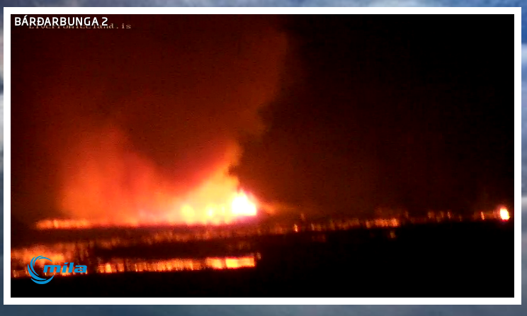
The new crater soon after it started erupting. Screen-shot of Míla web camera. Copyright of this image belongs to Míla.
- The lava field is getting close to Jökulsá á Fjöllum glacier river. Once that happens steam explosions are going to start and local ash clouds are going to be created. They won’t have any effect on anything but the local area. Once the lava field gets into the glacier river it is also going to show higher conductivity on instruments that are monitoring the glacier river downstream. Due the volcanic material getting into the glacier river.
- There is a risk of fissure opening up under the glacier without warning. Both close and at more distance from current eruption site.
Article updated at 03:39 UTC on 02-September-2014.
Article updated at 22:27 UTC on 02-September-2014.
In geology, a fissure is a fracture or crack in rock along which there is a distinct separation; fissures are often filled with mineral-bearing materials. On volcanoes, a fissure is an elongate fracture or crack at the surface from which lava erupts. Fissure eruptions typically dwindle to a central vent after a period of hours or days. Occasionally, lava will flow back into the ground by pouring into a crack or an open eruptive fissure, a process called drainback ; sometimes lava will flow back into the same fissure from which it erupted. A fissure vent, also known as a volcanic fissure or simply fissure, is a linear volcanic vent through which lava erupts, usually without any explosive activity. The vent is usually a few meters wide and may be many kilometres long. Fissure vents can cause large flood basalts and lava channels. This type of volcano is usually hard to recognize from the ground and from outer space because it has no central caldera and the surface is mostly flat. The volcano can usually be seen as a crack in the ground or on the ocean floor. Narrow fissures can be filled in with lava that hardens. As erosion removes its surroundings, the lava mass could stand above the surface as a dyke. The dykes that feed fissures reach the surface from depths of a few kilometers. Fissures are usually found in or along rifts and rift zones, such as Iceland and the East African Rift. Fissure vents are often found in shield volcanoes.At Iceland, volcanic vents are often long fissures parallel to the rift zones where lithospheric plates are diverging. Renewed eruptions generally occur from new parallel fractures offset by a few hundred to thousands of metres from the earlier fissures. This distribution of vents and voluminous eruptions of fluid basaltic lava usually build up a thick lava plateau rather than a single volcanic edifice. Laki volcanic fissure system produced the biggest eruption on earth in historical times, in the form of a flood basalt, during the Eldgjá eruption A.D. 934, which released 19.6 km³ (4.7 mi³) of lava.so basically a Fissure eruptions is what makes a Shield volcanoe, it form little to no ash as long as there is no water or ice involved. The lava they release flows in all directions from the vent. If the pressure builds in a fissure volcano, a wall of lava spews into the air. In volcanoes with less pressure, the lava bubbles to the surface and flows slowly to form new rock.Fissures can be small, wide, long,from a few metres long to km long cracks. so there is no true”fasit” to it.
Magma forms deep in the earth. Because it is lighter than the materials at the earth’s surface, it tends to rise. Underground, magma works its way through interconnected chambers toward the surface, seeking a weak spot in the earth’s crust to escape. If magma finds a central vent, it escapes to create conical volcanoes. Small central vent volcanoes spew lava high into the air where it solidifies before hitting the ground, forming a cinder cone. Larger central vent volcanoes form lava cones that are eventually blown away by a volcanic explosion, such as what occurred with Mount St. Helens.
“… so basically a Fissure eruptions, … it form little to no ash as long as there is no water or ice involved. …”
Keep in mind Laki produced copious gas haze and light component solids that circled the northern hemisphere (the ‘sand summer’ of Europe and ‘the Laki haze’ were the terms used), regardless of no significant water or ice being involved. In these Icelandic rifting situations it’s seems to be the total quantity erupted in cubic km that becomes more significant than the eruption sequence styles.
yes, but Laki, was enourmous in size,and yes it produced the haze,but it was not ashfall,it was gases and steam containing serious poisonus compounds,sulfuric acids and flourides.,On iceland it self it was a disaster,killing lifestock and people due to its poisonus gass release.if we add Water and Ice it becomes explosive and rich in ash.We can not rule out that Ice and amounts of water was involved at the Laki eruption either.When it comes to this new eruption ,there is no or little ash produced, but there is lots of gasses co2 and sulfuric asids,and steam produced as we can see on the images. And if this eruption continues or grows there is notting stopping it to become something simmilar.
Latest from Holuhraun (north of Vatnajökull).
Bárðarbunga – updated information
In this article, updated information on the Bárðarbunga seismic activity is given with daily status reports from the scientist of IMO and the University of Iceland. New material is added to the top of the article. The original information is at the end of the article. Therefore, from bottom to top, this article gives an overview of events. For additional material, check also the news list on our front page.
Visual material
Photos from fieldwork are available in another article.
Web-cameras from M&T ehf are watching the area in various directions.
Web-camera from Míla is watching Holuhraun where a small lava eruption took place. Please observe that Míla’s background photo has nothing to do with the current events.
Updated information
2nd September 2014 12:00 – from the Scientific Advisory Board
Scientists from the Icelandic Met Office and the Institute of Earth Sciences and representatives of the Civil Protection in Iceland attend the meetings of the Scientific Advisory Board of the Icelandic Civil Protection
Conclusions of the Scientific Advisory Board of the Icelandic Civil Protection:
A noticeable decrease in seismicity has occurred during the last 24 hours. The level of activity is approximately half of that during recent days. Since midnight today, around 300 earthquakes have occurred. At the same time yesterday, 01 September, around 500 earthquakes had been detected.
The rate of deformation at GPS sites closest to the dyke intrusion has decreased. Together with an overnight decrease in seismicity, this implies that magma inflow appears to match magma outflow at the eruption site.
The eruption has not created any ash-fall.A white plume of steam and gas rises from the eruption on Holuhraun, reaching an elevation of about 4.5 km above sea level. Downwind, a volcanic cloud extends from the eruption site. Yesterday afternoon a white cloud from the eruption extended 60 km to the north-north-east.
In comparison to yesterday, more sulphur dioxide has been measured in the eruption cloud.
Sandstorms on the floodplain around the eruption site have contributed fine-grained particles to the eruption cloud. This was seen as a light-brown haze earlier today near to Egilsstaðir.
The eruptive fissure is about 1.5 km in length, positioned about 4.5 km from the ice margin of Dyngjujökull.
At 14:00 UTC yesterday, the lava flow was 4.2 km2 in area. At 08:00 UTC the edge had extended 1.5 km to the east-south-east.
The eruption continues, although there appears to have been a slight decrease in activity compared to yesterday.
It remains unclear how the situation will develop. Four scenarios are still considered most likely:
The migration of magma could stop, resulting in a gradual reduction in seismic activity and no further eruptions.
The dike could reach the Earth’s surface causing another eruption, possibly on a new fissure. Lava flow and (or) explosive activity cannot be excluded.
The intrusion reaches the surface and another eruption occurs where either the fissure is partly or entirely beneath Dyngjujökull. This would most likely produce a flood in Jökulsá á Fjöllum and perhaps explosive, ash-producing activity.
An eruption in Bárðarbunga. The eruption could cause an outburst flood and possibly an explosive, ash-producing activity. In the event of a subglacial eruption, it is most likely that flooding would affect Jökulsá á Fjöllum. However it is not possible to exclude the following flood paths: Skjálfandafljót, Kaldakvísl, Skaftá and Grímsvötn.
Other scenarios cannot be excluded.
A new fissure or maybe a re-opening of a fissure in the south part of the area that is erupting has now happened. At the same time the north end of the fissure that was most active today seems to have stopped erupting. If I am seeing things correctly on the web camera. I might not be doing so. If this is correct that I am seeing, it is going to be confirmed during the day.
There are no signs of the eruption slowing down or stopping.
Thor , thank you for comment, very easy to understand. What I don’t understand are the comments about bardarbunga . Is it getting ready to erupt ? What are the signs? And why would it be something to write about in history books. I’ve tried reading things about caldara volcanos but all I get is yellowstone . Thanks in advance for answering. Shel from Pa, USA
What I mean by that is if Bårdarbunga opens up at its main crater and blews the icelid of,it might become far bigger than the Eyjafjell eruption.There is an enourmous icecap on Bårdarbunga, and that means troubble.But remember that this fissure eruption can also become something very serious,if it grows in size and strength and continues on for days, weeks and months.Just look at Laki and what that did. That was also a Fissure eruption, taking place between Myrdalsjøkull and Vatnajøkull, and was simmilar to this and it comes from the same volcanic system.
jon, what about the caldera and barda now? can u risk a % of probability now?
Seems like quake activity down some (not much), and CGPS stations seem to have stabilized at there current positions.
Captcha is clearly faulty!!
I don’t seem to have any problems with it? I’d rather a faulty captcha than a forum full of spam!
It is when you’ve typed a long post and it then won’t work, even when the numbers are clear as day. Even refreshing the captcha wouldn’t work.. ultimately I refreshed the while page and list my post in the process :@
Maybe you’re forgetting the other spam test where you have to add/subtract numbers?
If you write a long comment. Then don’t refresh since the comment section does not save your comment.
If you want to get rid of the anti-spam bot tests then you need to register. Spam bots are a massive problem for me, so I had to make it close to impossible for them to spam my website.
There are two anti-spam bot tests. Capatcha word test and also a maths test.
Even if this is in place. I still get a spam comment once in a while going trough.
Yes it is. Jon told me to register. Bingo – no slap-catchya! 🙂
looking like Kverkfol may be getting the next action, it appears to be re-filling the sys there.
i still believe it is the first caldera that will break, prob sept 4-5 on the reset…
Not sure, but looking at the Mila webcam, I have the impression that the eruption is moving southwards towards the mountain/glacier. If that is the case and if it will continue, we could see much more action than currently
Slabby Pahoehoe lava – and lots of it
September 1. 2014, at 20.14 GMT
The lava flowing from the fissure north of Vatnajokull is classified as Pahoehoe lava – a type of basaltic lava that is very common in eruptions in Iceland. The term comes from Hawaii and means smooth unbroken lava. The lava at Holuhraun is so thin however, that it forms slabs on the surface.
Considerable amount of sulphuric gas rises from the lava, making it essential for scientists in the area to have gas detectors and gas masks available.
http://www.ruv.is/frett/slabby-pahoehoe-lava-and-lots-of-it
Remains of Hurricane Cristobal cross Iceland Volcano
Sept 2, 2014 – Continuous lava eruption is under way. A few hours after the eruption, reports list the airborne ash particles are minimal.
The Aviation Color Code was raised to Code Red then lowered back to Code Orange.
video and photos
http://www.accuweather.com/en/weather-news/second-eruption-occurs-in-icel/33055466
3.1 in the area of the caldera:
Tuesday
02.09.2014 11:26:50 64.679 -17.484 6.1 km 3.1 99.0 4.7 km NNE of Bárðarbunga
It looks bigger here in several of these plots: http://hraun.vedur.is/ja/drumplot/vatnajokull.html
http://www.emsc-csem.org/Earthquake/earthquake.php?id=398077
Yup, just updated to a 4.7!
And another 4.6 in the vicinity of the caldera….
Looks like it is over for now
Fissure eruptions stop and start again after few hours. This might not be the end of it, even if there is currently a drop in activity.
it goes in pulses,. but to me it seem like its calming down a bit, but that could also be that there is something brewing for later,.
Another 4.6 ish under bardabunga
Looks like all the EQ under Bardarbunga are on the same depth (6-7) km
Any reason to explain that?
Thanks for your coverage Jon!
Harmonic tremor is dropping at the moment. This is being followed by increase in earthquake activity it seems.
what could that lead to? sugestions?
Hi Jon with seismic activity decreasing do you think pressure would build up again, what is the status on Bardarbunga and Askja,I have noticed there’s still earthquake activity around the caldera. What are the chances of this collapsing and leading to an eruption. Also I have noticed seismic activity still around Askja.
Looks like the IMO website just crashed. Can’t get access. Says the reuested URL can’t be retrieved anybody else getting this?
Never mind back up again!
Down again 🙁
In case you have not seen this incredible video from yesterday mornings lava…..
https://www.youtube.com/watch?v=o_kfZhZxpxA
Wonderful footage, but I wish people didnt think it was necessary to overlay everything with loud music. The natural background sounds would have been more evocative of the grandeur of the sights.
I know what you mean…it’s so overdramatizing (didn’t know if this word exists)…i will remember these hours in front of the webcam with little hum from my computer…
IMO website not reachable from the UK either.
I know, I’m in the UK :p
Back up ATM, notice theres a wee note about the phones being down, perhaps the two are connected.
IMO website reachable for me (I’m in Kent)
I can get the IMO site from the UK at the moment
Something I’m curious about is that all the larger earthquakes are taking place in or around the Bárðarbunga caldera, while all the outlying earthquakes are much smaller. Is this only because the volcano has much larger masses of rock and magna to displace, and the outlying areas are already full of fissures and therefore don’t require as much force to accomplish displacement? Or is it (probably) much more complex than that?
Looks like various parameters are settling down now. This just keeps the suspense going. Now what is it going to do? Stay tuned for next episode of…
I wonder if we will have something similar to Eyjafjallajökull, a fissure eruption first then the main event later?!
Many of the great historical erution was fisure eruptions like Laki. There are small fisure eruprion and small caldera eruptions and great ones. The point is to get lava to the surface to build new land.
It might, or it might not, depends on how, where and if the magma can work its way through the sediments, rock and ice, or it chooses another direction. If it starts to erupt under the icecap, we might get a large spectacle like Eyjafjell, or it might just become to small and weak to do anything else than make a lahar/gjøkulllhaup wich can be bad enough, or it can just make a flat mountain under the ice and we dont get to see anything. Volcanoes are just too unpredictable to really say what they are up to or what theyr next moves are. This time it found a way up through the dyke and created a fissure eruption, quite simmilar to fimvørdurhals eruption, even thoug this time it was actually quite larger. Now ,It can surely choose to continue to erupt at that area or the magma can choose to go in other directions or it just might calm down and retract to the deep where it came from. its just simply no way to tell, We might even get an eruption at Askja or near by areas. But at the moment it seems like it calming down a bit. But its still really high quake activity in the area so its not quite finished and it might quite fast pich up pace again.
Activity on the web cam seems to be picking up and is rather intense at some smaller areas.
Iceland: Watch Bardarbunga blast volcanic lava: http://youtu.be/Z5cDIutN_ZM
Thanks Andrew in finland ,this footage is even more evocative!
Looking at Mila camera 2 just now. It looks like the gas from current eruption is having an impact on the slow moving cloud above. The mountain in the backgroud also seems to have such cloud forming. Could it be that gas is getting through the ice sheet and although not visible is creating cloud over crater. Just an idea.
I see we have our first quake to the south-west of Bardarbunga.
there is still some action at the fissure, not so big and vigurous as yesterday, but still live and kicking.
I note large emissions of SO4. Any implications for people and livestock?
I meant SO2
Can anyone tell me what the blue, red and green colours mean on the harmonic tremors pls ?
They mean frequency of that the seismometer detects. 0.5 – 1Hz is the low band. 1 – 2Hz is the middle band and 2 – 4Hz is the high band.
I’ve read that the blue band is more indicative of earthquake activity while the red and green are more indicative of volcanic tremor — but would be glad to hear a better explanation.
The low band is more active when magma or fluid is on the move. It also goes up when glacier flood happens. I am not sure why that is.
Thank you Jon…
Some good views on mila 2 tonight
At Bardabunga cam 1 is a little white/grey spot a little bit more at the right side than the eruptions. I don’t know if this could be smoke from the ground?
Oh, why have I go to work every day (ok, ok, I need the money for the next trip to iceland 😉 )…
Jon you are great work with your input, can you tell me what the status is regarding Bardarbunga and Askja, and do you think Barda will erupt due to still having strong seismic activity around the caldera. I must admit Mila 2 is looking great now it’s dark.
EQ activity seems to be building…heading for a big quake ?
Hi just a quick question, on the mila cam 2 which way is it looking? East, west, etc
Southwest
Thanks 🙂
So the camera is located in the northeast looking towards the southwest, and the fissure runs northwest to southeast?
Yeah they’re located somewhere on a mountain named Vaðalda http://mapcarta.com/17596792
Mila 1 cam has a great orange glow !
Watching and learning from Dallas, Tx USA. Thank you all!
Custom plots of the NESDIS data.
http://shrani.si/f/3S/Cj/1OKufsgQ/11.png
http://shrani.si/f/3x/eQ/3qasziy9/22.png
waiting for a big boom…sooner or later
I am going to take the day off today (2-September-2014) and maybe 3-September-2014 if nothing major happens. It has been a busy two weeks for me following this and writing updates.
If anything happens I am going to update this article. If anything major happens I am going to write a new one.
Please note that the lava field is getting close the Jökulsá á Fjöllum glacier river. Once the lava field gets into the river it is going to create steam explosion (this happened today) that are going to create a minor ash clouds that are only going to effect the local area. I don’t know when the lava field is going to get into the river, that might be in next few hours to days. Depending on the output of the craters and the output from the craters can be different and has been different since this eruption started.
Here is an animation from the MACC forecast. The SO2 amounts are questionable, but nonetheless, the plume direction and speed and dispersion seem to be very decent, especially the direction and speed, to give you the idea.
http://shrani.si/f/o/Mv/1FWxRjMS/output5wkagp.gif
High res:
http://gifmaker.me/PlayFrameAnimation.php?folder=20140902093PdhoWRLdaX5qTRptSdzHi
Minor updates added to the article.
Enjoy your break, Jon
Really appreciate the effort you put into keeping us informed
Hey everyone, great site Jon. Found a old book on one of my trips through google with a short but detailed description of the Laki eruption.
http://books.google.co.uk/books?id=30LYvn1SIZsC&pg=PA63&lpg=PA63&dq=buland+village+iceland&source=bl&ots=kwYsQWUw8J&sig=TOlGnr-9cdmqlqR1-PgTW11TELY&hl=en&sa=X&ei=LFcGVNrPNYbD7Aa59IGwAg&ved=0CCMQ6AEwAg#v=onepage&q=buland%20village%20iceland&f=false
If you combine the description with this old map of Iceland http://myndir.islandskort.is/map/Fra_Homann_til_Jons_Eirikssonar_17/Insvlae_Islandiae_delineatio_4/839/2011-11-09-15-31-09.pdf
It really shows just how big these eruptions can be and how much they can change the landscape.
Some of the volcanic tremor plots are sky rocketing. Anything happening?
Question, what is up with this quake, not where it’s going off??? Thanks.
http://www.emsc-csem.org/Earthquake/earthquake.php?id=398152#summary
click on maps and see what I mean.
http://geofon.gfz-potsdam.de/eqinfo/event.php?id=gfz2014rfwn
5.2 QUAKE
Its not showing up on the Iceland met site. They have a 5.4 around Bard recently but that’s it.
This all is getting crazy. Volcanoes going off everywhere. I check a few sites and they all are different. IMO said, 5.5.
What’s everyone’s opinion on the status of Bard itself?
Still watching the travel date inching 3 days away. The latest HYSPLIT NOAA model has all ash in UK airspace with an explosive eruption at Bard, on the 3rd or 4th due to what looks like a Low pressure system between Iceland and the UK.
Those are some ominous earthquakes occurring at Bard tonight. How are volcanic tremors looking?
I think Big B is gonna crack off of big 6 pointer or two just before she blows. She has been having quakes that would normally be associated with an imminent eruption for sometime now.
A smaller fissure eruption could very well be on the way E to NE of Askja. Deformation has stabilized and yet quakes still persisting here. This area has seen quake activity for quite some time prior to the current event. The fracturing at depth that has gone on may have allowed magma to make it up here but with less pressure as it is at the farthest extent from main plume. Even still, eruptive activity could still happen IMHO.