
This is a short update on current status in Bárðarbunga volcano and the eruption. This information is going to get outdated quickly.
Current status in Bárðarbunga volcano
- Earthquake activity remains reactively high at the moment. Strongest earthquakes today had the magnitude of 4,9, 5,0 and 5,3. Other earthquakes have been smaller.
- Dyke activity remains high and eruption remains high. See more details below.
- Risk of eruption in Bárðarbunga volcano caldera remains high.
- There is nothing suggesting that current events are about to end.
Current status of the eruption in Holuhrauni lava field
- Eruption dropped this morning, but after 12:00 UTC it increased again. There does not seem to be any change the dyke that is feeding the eruption.
- Sulphur (SO2) is being released into the atmosphere, according to measurements that is around 20,000 tonnes/day. Good map can be found here, the news in Icelandic.
- According to the news, this eruption is about 5 times larger than the eruption in Fimmvörðuhálsi in Eyjafjallajökli. One geologist told in the news that this eruption had erupted everything that Fimmvörðuháls eruption did in it’s time around 12:00 today (If my memory is correct on this).
- The lava field continues to grow. I am not sure about exact size at the moment.
- Pressure in the dyke appears to be high. This might result in more fissure eruption and there is a high risk that some of them might open up under the glacier. More is going to be known tomorrow if the dyke pressure is changing.
- Northern part of the fissure is more active than the south part. Part of the fissure has closed and is not erupting any more. That might change without warning if the eruption gains more strength.
- This eruption is might continue to for weeks or even moths.
If there is any sudden change I am going to post information soon as I can.
News bits
Close-up view of fresh Icelandic lava (Rúv.is)
Gosið ennþá nokkuð kröftugt – loftmyndir (air video, Rúv.is)
Updates
New crater opened up suddenly. It is far north on this image (to the right).
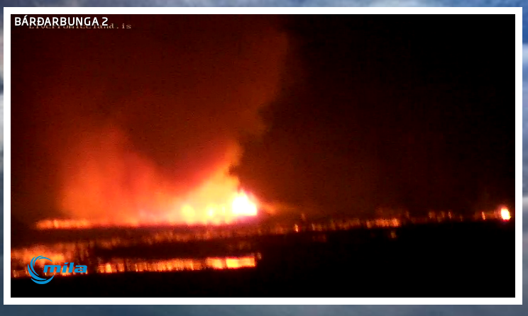
The new crater soon after it started erupting. Screen-shot of Míla web camera. Copyright of this image belongs to Míla.
- The lava field is getting close to Jökulsá á Fjöllum glacier river. Once that happens steam explosions are going to start and local ash clouds are going to be created. They won’t have any effect on anything but the local area. Once the lava field gets into the glacier river it is also going to show higher conductivity on instruments that are monitoring the glacier river downstream. Due the volcanic material getting into the glacier river.
- There is a risk of fissure opening up under the glacier without warning. Both close and at more distance from current eruption site.
Article updated at 03:39 UTC on 02-September-2014.
Article updated at 22:27 UTC on 02-September-2014.
For those of you who have access to Amazon Prime streaming video, they are carrying all seasons of the general public science program, Nova. Season 9 episode 1 is titled Doomsday Volcanoes. It was produced after the 2010 eruption of Eyjafjallajökull, and focuses on Hekla, Katla and Laki, but much of the information (though it is sensationalized, in my opinion) is pertinent to what we’ve been watching at Bárðarbunga. And the scenery is nothing short of spectacular. One thing that came up in the program is something that Jon has mentioned, the possibility that some of the volcanoes may be linked by über ground fissures. Well worth watching even if it is somewhat short on geophysics.
I dont have access to that video – but I followed ‘skull’ volcano (easier for me to spell) in 2010 and I recall the news if Katla blew it’d be bad.
I asked a couple days ago on here if KATLA might be affected by Bard but never saw a reply.
Perhaps no one knows.
I’m, that was supposed to be underground fissures. I didn’t know my keyboard could do that!
I thought you meant that there was a large amount of magma in the ground fissures, thanks for clarifying.
Jón Frímann,
you deserve a couple of days off, but will planet Earth allow you that privilege.
Lots has happened over night. Is that the largest quake I have seen in Bárðarbunga crater? and it certainly looks like the fissure has become more active?
Does anyone have the link to the youtube stream by Burre please? I can’t find it this morning.
https://www.youtube.com/watch?v=zKtGqoxV_qo
But Mila 2 looks better http://www.livefromiceland.is/webcams/bardarbunga-2/
Thanks, did have a look on MILA cams – your youtube link isn’t live either. Wondering if he’s stopped the streaming which would be a shame.
New live streaming site,
https://www.youtube.com/watch?v=eApt4bGlXYU
http://george-photoworld.blogspot.gr/2014/08/bararbunga-volcano-livestream.html and this but now stoped
Thanks Liz – well your keyboard slup ‘uber’ in fact certainly sums up the situation haha nice one! Everyone here with english as a second language – you’re extremely articulate – most of my fellow Australians don’t have english as a first language either(!) Respectfully in the hope it may help you in future, ‘captcha’ is spelt capture 🙂 i know how much scientists love and follow astrology, so thought to offer that a reputable astrologer forecast next week for B to express the loudest biggest possible exclaimation to the Sky Gods
Thats interesting!.Come on, give us your prediction!
re my comments concerning cloud formation over gas venting, still apply in todays images.
https://www.youtube.com/watch?v=zKtGqoxV_qo
I think a lot of gas maybe venting through the ice and producing lower cloud over the table mountain in the distance. Can someone confirm if that is Bárðarbunga volcano?
Still applies because you’re watching a repeat 😀
An Icelandic Tourist Board promotion film. 🙂
There’s a new stream:
https://www.youtube.com/watch?v=eApt4bGlXYU
Did Bar erupt? There is a wedge shaped “cloud” on top of the mountain in the background of the fissure.
That was not what I was suggesting.
Aerosols are well known for cloud production and I was thinking that you may be able to see if gas aerosols were coming up through the ice to form specific types of cloud where activity is taking place under the ice. Could make a good research project.
Sample paper on the subject.
http://129.82.48.46/AT620/papers/Andreae-AerosolsPrecip-ESR2008-1.pdf
So diagnosis of aerosols escaping the glacier could help with discovering subglacial eruption sites?
Could higher conductivity in Jökulsá á Fjöllum due to lava entering the river, mean that it would be more difficult for scientists to detect a subglacial eruption, as this signal would cover up another source of conductivity?
On the other hand, this would probably just be re. Dyngjujökull, not Bárdarbunga, because there a signal should also show up in other rivers like Skjálfandafljót or Kaldakvísl.
Wohoo, Dustdevils at the eruption site
http://s1.directupload.net/images/140903/95iuolxc.jpg
Someone should go there and make some really awesome photos
if only i could 🙁 with my tripod, my dslr, my filters ,at night
There is a new YouTube livestream here: https://www.youtube.com/watch?v=eApt4bGlXYU
and this from site http://george-photoworld.blogspot.gr/2014/08/bararbunga-volcano-livestream.html
‘Journey to the center of the Earth’ Earthquake at 27.6km!!!, it’s only a 1.3 so could it be an error?
from http://www.ruv.is/frett/cannot-rule-out-an-eruption-at-bardarbunga
A volcanic eruption under Vatnajökull glacier cannot be ruled out. The seismic activity in the area is still great, despite a slight reduction. The eruption at Holuhraun is still going strong and there is a risk of gas explosions if the lava reaches a nearby river.
This footage was taken by reporter Ómar Ragnarsson who flew over the eruption site at Holuhraun yesterday. Access to the eruption area is currently restricted to scientists and media personnel, with the prior approval of the Icelandic Civil Protection Agency.
Risk of gas explosions
Kristín Jónsdóttir, geophysicist at the Icelandic Met Office says that access to the site is restricted because of the risk of explosions. Lava from Holuhraun eruption is flowing towards the nearby glacial river Jökulsá á Fjöllum, Iceland’s second largest river which flows from Vatnajökull.
Kristín says that the lava is already quite close — currently about 6 kilometers from the river — and will probably reach the river eventually. When the lava meets the water, powerful steam explosions can be expected. Such explosions can release dangerous gases.
Cannot rule out an eruption beneath the glacier
The seismic activity in the area has decreased somewhat but is still significant. Around five hundred earthquakes were detected in and around Vatnajökull yesterday, three of them magnitude 4 and over.
Kristín says that if the current fissure lava is flowing from closes, there is a possiblity that the eruption might create new fissures, possibly to the north or to the south, closer to Vatnajökull glacier. Therefore, an eruption at Bárðarbunga, beneath the glacier, cannot be ruled out.
There is clearly something going on. Harmonic tremor has changed on two SIL stations around Bárðarbunga volcano. That SIL stations are Vonaskarð and Dyngjuháls. It also appears on other more distant SIL stations, but is not as clear there.
Roads have now been closed due to flood risk from an eruption under the glacier.
The southern cluster appears to have been migrating very slowly back southwards over the past 36-48 hours, wont be long before the swarms are centered under the glacier again.
I know this question was here before, sorry for that, but where on cam 1 is the volcano exactly? On the right is the plume. Is it the mountain on the right, behind the smoke?
Allwhat you see in background is the glacier, from left to right. Bardarbunga lies a little bit at the right side, perhaps from this view behind the right mountain, behind the plume.
Harmonics are rising all over iceland at the moment.
Fantastic dust devil by the way!! Gone…..
From RUV.is:
BREAKING: Pressure in the magma north of #Bardarbunga #volcano increasing. A wide and deep depression has formed in the glacier. -scientists
New short article about the eruption under the glacier is up.
Can someone tell where to find the dyn tremor graph please? It seems to have been removed from the list on vedur.
Here it is – http://hraun.vedur.is/ja/oroi/dyn.gif
And median filtered is here: http://hraun.vedur.is/ja/vatnajokulsvoktun/dyn_trem.gif
It looks very interesting, we haven’t seen such pattern since the very beginning of the activity in August.
http://hraun.vedur.is/ja/oroi/dyn.gif
Thank you both very much 🙂
here you are Nonchalent…..
http://hraun.vedur.is/ja/oroi/dyn.gif
Any explanation for the green spike today on http://hraun.vedur.is/ja/vatnajokulsvoktun/dyn_trem.gif ?
Here too (which is probably the same data) http://hraun.vedur.is/ja/oroi/dyn.gif
Happened around the time of the big 5.5 quake, but not limited to that.
D’oh, new blog post … which is probably about what explains it …