
This is a short update on current status in Bárðarbunga volcano and the eruption. This information is going to get outdated quickly.
Current status in Bárðarbunga volcano
- Earthquake activity remains reactively high at the moment. Strongest earthquakes today had the magnitude of 4,9, 5,0 and 5,3. Other earthquakes have been smaller.
- Dyke activity remains high and eruption remains high. See more details below.
- Risk of eruption in Bárðarbunga volcano caldera remains high.
- There is nothing suggesting that current events are about to end.
Current status of the eruption in Holuhrauni lava field
- Eruption dropped this morning, but after 12:00 UTC it increased again. There does not seem to be any change the dyke that is feeding the eruption.
- Sulphur (SO2) is being released into the atmosphere, according to measurements that is around 20,000 tonnes/day. Good map can be found here, the news in Icelandic.
- According to the news, this eruption is about 5 times larger than the eruption in Fimmvörðuhálsi in Eyjafjallajökli. One geologist told in the news that this eruption had erupted everything that Fimmvörðuháls eruption did in it’s time around 12:00 today (If my memory is correct on this).
- The lava field continues to grow. I am not sure about exact size at the moment.
- Pressure in the dyke appears to be high. This might result in more fissure eruption and there is a high risk that some of them might open up under the glacier. More is going to be known tomorrow if the dyke pressure is changing.
- Northern part of the fissure is more active than the south part. Part of the fissure has closed and is not erupting any more. That might change without warning if the eruption gains more strength.
- This eruption is might continue to for weeks or even moths.
If there is any sudden change I am going to post information soon as I can.
News bits
Close-up view of fresh Icelandic lava (Rúv.is)
Gosið ennþá nokkuð kröftugt – loftmyndir (air video, Rúv.is)
Updates
New crater opened up suddenly. It is far north on this image (to the right).
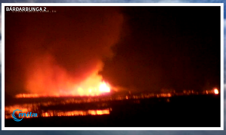
The new crater soon after it started erupting. Screen-shot of Míla web camera. Copyright of this image belongs to Míla.
- The lava field is getting close to Jökulsá á Fjöllum glacier river. Once that happens steam explosions are going to start and local ash clouds are going to be created. They won’t have any effect on anything but the local area. Once the lava field gets into the glacier river it is also going to show higher conductivity on instruments that are monitoring the glacier river downstream. Due the volcanic material getting into the glacier river.
- There is a risk of fissure opening up under the glacier without warning. Both close and at more distance from current eruption site.
Article updated at 03:39 UTC on 02-September-2014.
Article updated at 22:27 UTC on 02-September-2014.
Here is another source for SO2 outgassing:
http://www.sacs.aeronomie.be
At odds with your post is there an explaination for this current very quiet period or is it a calm before the storm moment.
Oops, sorry, it’s http://sacs.aeronomie.be“
Might Katla be affected?
No, Katla is located at Myrdalsjøkull, and is close to Eyjafjell. they are located at a totaly diffrent volcanic branch,even thoug all of the volcanoes at Iceland has the same source deep in the hotspot mantle, they are not really connected.Look at it as a large lake with rivers that comes out from that same lake,and the water move in diffrent directions,they dont affect eachother,and one river can dry out,while another is flowing very well. So No katla is not being affected byt this eruption. The volcanoes that can be affected is Grimsvøttn,Kverkfjell,Bårdarbunga it self, and not least Askja. But Askja is not directly connected to this eruption, it might get so much stirr and shaking,that her magmachamer starts to fill,she has had quite some unrest the last few years, so she is in some state of unrest allready. The magma/lava from this eruption has been moving toward Askja volcanic field. But the ground and rocks i that area is quite hard,granite rich rock and mountain. So If the magma shall intrude and break way in that area it has to has some quite resillient powers and stamina. usually magma just finds the easy way up and around obstacles it cant break through. But never say never. nature has a way of doing things it own way sometimes, and we can never rule out 100% and say that Askja wont have an eruption.She is still in yellow warning, due to the unrest and all the earthquakes in the area. Now when it comes to Katla, she lives it own life,and if something happens there its not because of this eruption, but by other factors,lets say maybe a big earthquake , that triggers magma movement into the magma chamber underneath Myrdalsjøkull,.We know that Katla sometimes have eruptions, a time after(a few years) when Eyjafjell has had eruptions and vice versa. But that is not set 100% in stone either. She goes of when she is ready to go of. So dont worry about Katla at the moment. Now its Bårdarbungas time to make a show,and so far its quite a nice one, and hopefully it stays like that and not becomming something we might write about in years in the historybooks as totaly devastating and terrible.
Is the lava that is erupting being replaced from a limited reservoir of magma, under Bárðarbunga, that will be exhausted, or is it coming from an unlimited supply of hot, light lava from underneath it? How do scientists decide whether the eruption is likely to decrease as the supply diminishes, or whether it will increase as hotter lava continues to make a clearer and bigger channel from the mantle?
Would the decrease in the reservoir in Bárðarbunga cause a significant decrease in pressure from above, causing more magma to move up? What sort of time scale does this operate on? What is the likely speed of magma moving upward, in meters per hour, do you think? Also, what do these fissures actually look like – are they cracks about a meter wide, reaching down kilometers? Wider? Narrower?
Thanks for sharing your knowledge about these things!
Does anyone know whether Mila Bárðarbunga 2 is down? There was only a blank screen for a long time, and now error messages.
Try it again…the cam is not down…yesterday a must do it several times before i got it…
Is it my eyes or is the smoke getting darker .?
The light changes very often in Iceland, when clouds drift by…sun goes down…
Just saw this tweet, interesting stuff from folk who are on the ground at Holuhraun.
Did you see this one , with sunlight:
https://twitter.com/Sim0nRedfern/status/506525896862605312/photo/1
or this one without sunlight:
https://twitter.com/fencingtobba/status/506532749638123520/photo/1
Thank you for posting the two pictures .
Bardarbunga slowly sinking
Sept 1, 2014 Pall Einarsson The strongest earthquakes have been detected along rim of the caldera in Bardarbunga, a subglacial volcano.
These strong earthquakes are the consequence of magna streaming out of the chamber beneath the caldera. The magma chamber is clearly subsiding, thus reacting to the considerable amount of magma that has been streaming out towards the dike intrusion. Analysis of these earthquakes supports this conclusion, as well as nearby GPS measurements of land deformation. We call this pressure changes in the roof of the magma chamber; in effect, the top of the volcano is sinking ever so slightly.
http://www.ruv.is/frett/bardarbunga-slowly-sinking
I tried to post this hours ago but the capcha is too unreadable -wouldnt go thru
If you register then you don’t have to deal with capcha challenge.
I thot I was registered – where is a link?
It is under “Meta”, between the two small Amazon ads. People don’t have to register to comment here, but if they are not registered they to have to take the spam bot test in order to comment.
If you’re using the mobile site, you need to go to the full desktop site. There is a link to it at the bottom of the page.
all people with variations of dyslexia have this problemObviously we are not computers
The gas released is SO2 as I remember 20.000tones a day??? How does this gas metabolise in the atmosphere?
Acid rain???
I don’t know the entire answer to that, but Laki is estimated to have produced 122 Mt of so2 in 1783-84. With the current so2-rate, we need 6100 days to reach that level. Laki caused global starvation due to dry weather in North Africa and India and a very cold summer in the northern hemisphere. The reason for this was so2 blocking the sun and causing a “year without a summer” in 1784…
…and Laki started off roughly like this, not ramping up until after a month (if I got it right). I really hope we are not getting there, but it is not entirely unlikely…
…and then we have the component of the current lava streams taking part in Askja fissures to count in as well. And also a possile caldera failure at Bardarbunga. I am definitely a bit worried…
There are less quake at the moment..?!
http://en.vedur.is/earthquakes-and-volcanism/earthquakes/vatnajokull/
Yes, that appears to be the case. I am not sure why that is. There is also drop in harmonic tremor at Vonaskarð SIL station and other SIL stations that are not picking up the eruption harmonic tremor.
Quake activity seems to be relaxing a little bit in the last couple hours. At this point means nothing unless that continues.
http://en.m.wikipedia.org/wiki/Sulfur_dioxide
i like the moon next to the eruption
Thanks!
Find the moon!
http://abload.de/img/14-09-01-004-bardafxjnn.jpg
LOL! Hey diddle diddle, the smoke rose over the moon!
I noticed the darker smoke but it might be because of the light from the setting sun!
I have followed this website for a few years and viewed this site when nothing has been happening. What I admire is the the Icelandic authorities and how they handle this event. Its almost like….yeah we have a bit of a fissure going on but it happens! They almost seem proud and so they should be because Iceland is a fascinating country. 3 scenario’s possible….it falls away, it continues at this level for however long, or it blows. Stay safe Icelandic people….we salute you !
Iceland grows and Britain shrinks.
Jon…we all follow you. But we know little about you?
All we need to is he’s the Icelandic Man Of Mystery! 🙂
Darn it, forgot to put ‘know’ in the sentence! Doh.
Hi Jon,
Thank you for your information, it is easy to understand but………….!
I would like to know that everyone is safe in Iceland, I know that the area of this eruption is a no go area. But will the gases be harmful?
Thank you x
Just now – first time today – I saw fire instead of smoke.
Its VERY HIGH! Anyone else?
it is very strong
Maybe time for another cycle its run roughly every 47-49 hours with another due tonight so may see activity pick up again soon.
Oh, I have to go to bed…but I have to stare at a webcam also…is it glowing or is it fire?
Either it’s an optical illusion or those lava fountains are high!! 🙂
I think it’s glowing, the smoke is picking up the orange from the eruption.
Just wondering and trying to comprehend everything: when experts are talking about the magma floating out of the volcano and the collapsing of the caldera, does this mean less chance of an eruption? Because pressure is decreasing? Or a higher chance because the magma has a easier way out?
Mila Bardarbung cam just zoomed in, it orange glow from the eruption.
local midnite coming up, time for some big action again….
Looks like about 50% of the time there is something big happening around midnite.
Just your typical stat fluke.
Sure wish wind direction would change. Dust and steam blocking our view. GRRR!
Oh well, at least view last night was awesome.
According to the 3d EQ map the EQs started very deep under Bardabunga. The the fissure grew at depth as basically 2 plates split. The EQs under Bardabunga remained at depth and slowly worked upwards, The fissure went off on its own. Rotating the 3d model shows little connection between Bardabunga and the fissure, they form two distinct structures. Is the fissure really connected to Bardabunga, doesnt look like it. It seams that Bardabunga has acted as a fusion point holding the 2 plates together in one point hence the pivoting twist in gps measurements around it. Is Bardabunga really sinking or just twisting and buckling ? If Barbabunga blows the fissure might rip very quickly south west. The deep and big EQs under Bardabunga are significant. I hope the rivet holds !
The eruption is clearly growing again. But the wind has come around after the remnants of the hurricane passed, not unexpected, but now the smoke is obscuring the view.
The beauty can sometimes be lost to the scientific mind.New world arriving.Our planet changes all the time and we must adapt to its changes.We are guests,not residents.We should enjoy our time and be fascinated.
It’s difficult to understand why gas release has not had any effect on either volcano. SO2 has freedom when it is simply vented into the athmosphere. But coming directly off a magma chamber under Bárðarbung,… well where is escaping? And if it has a means of escape does that mean that an eruptio will not happen?
I am puzzled by this big drop in earthquake activity. Tremors down as well, it seems all quiet when I look at the overall picture. Just like the last few weeks would not matter. And that little eruption definetly has not ejected enough material to release the pressure.
it is very intense now ooooooooooooooooooooooooooohhhhhhhhhhhh
Three new CGPS sites are added to the Bardarbunga CGPS site collection:
Fjórðungasalda (FJOC)
Gjallandi (GJAC)
Thorvaldshraun (THOC)
Each CGPS site is showing similar tension and also vertical oscillation effect from more distant locations as well. So the whole area is oscillating up and down, as it stretches on approximately east-west line. It’s not just the lid of Bardarbunga that’s moving up and down. In order to know specifically what it is doing you’d need a sensor right on top of it, and there isn’t one
We need better photos and time series surface mapping (LIDAR?) of the ice surface directly on top Bardarbunga to see what the movement really is, taking into account the ongoing distension, and not just resort to making competing preferred-theory based presumptions about the area.
I understood some of what you said, but how can there be not a vacancy by now between Bardabunga and the glacier?
There can be a, “no vacancy”, as you put it (I presume you’re using a translation service) because there doesn’t have to be a vacancy of the magma chamber. The magma can still be pouring into the system, even as the crust distends, because the volcano is in fact the crust and it will be distending too, hence the vertical oscillations in the CGPS.
distend–> inflate–> distend–> inflate–> distend–> inflate–> … that is what we are seeing in the CGPS.
The below photo from the article at noon on the 30th Aug 2014, shows ice above the volcano straining apart and separating into classic vertical doming uplift features in the ice. Those are not due to a slumping down of the top, which would show compression features and pressure ridges.
See the photo:
http://www.ruv.is/frett/gos-i-bardarbungu-talid-liklegra-en-adur
That’s extension of the ice area, and we need to know if that’s occurring over all of Bardarbunga’s top, because its consistent with magma inflation, not deflation (or ‘vacancy’) of the magma repository (as you’ve put it).
So we need more than theories and assertions here, we need precise time series measurements to obtain a definitive understanding of the situation under the ice at Bardarbunga. Probably it will require several military grade LIDAR terrain survey over the ice, combined with SLR and CGPS, to capture the actual movement trend with above and within the volcano.
[PS: I need to return to my regular activities later today, so no more volcano monitoring.]
guys is fantastic lava became a river oh god
Liking the night view of fissure eruption on Bardarbunga cam 2, still windy though!
If what you guys are saying about the twisting, oscillating of the land in this area & around Bardarbunga can’t be good in the long term can it?
One would think something has to ‘give’, big time somewhere!
hi is that a car on the far right of the cam or may new fissure . not sure
Wow look at the lava flow
it is incredible
150 meters like john said in twiter
What are you looking at? I have the Live Stream on and don’t see anything spectacular m, what are you all excited about?
where can i find the tremor measurements in Bandarbunga?
You can find them here.
http://hraun.vedur.is/ja/oroi/index.html
Text is in Icelandic.
0k thanks a lot
Unmentionalbe
Why can’t we just put a pole w laser reflectors on it, and measure from afar ?
Seems like cheaper that a seismo or gps kit, and could drop it from a copter from a few feet off the deck.
Works for the moon.
But what will you attach the pole to? The ice may be gone in 6 hours time. I think it’ll need to be a remote airborne sensor, preferably twice per day surveys, by a military grade LIDAR terrain mapping system of the ice sheet surface shape and volcano surrounds and combine it with the other geodetic data.
good night all of you here in Greece is 3:00 am ,i hope the eruption become stronger in my sleep as always.When i wake up i read again and again about the starting of the eruption both yesterday and friday haahhhaha
anyone trading this?
I am seeing more harmonic tremor on few SIL stations around Bárðarbunga. I am not sure what is going on at the moment. This looks like a start of new eruption under the glacier. I am sure details are going be clear in few hours at the most.
Got to wonder how much influence the glacier on top Bardarbunga has. The ice is a lot of added weight on top of a already collapsing caldera.
Jon, you could be right, check out this pix, looks wild. Thanks.
http://i60.tinypic.com/2rwrmsi.jpg
https://www.youtube.com/watch?v=zKtGqoxV_qo
CHECK IT OUT, WILD LOOKING.
Good pix and graphs.
http://www.volcanodiscovery.com/bardarbunga/seismic-crisis-2014/updates.html
Hello Jon and thank you for the massive effort you are putting into your work.
I’ve watched this from the start, but to me it seems that the intensity has picked up quite massively in the last couple of hours. Given the fast pace building the lava-river in the front an new fissures opening. And they’re opening to the south it seems. 3 or 4 new ones. (Shows in B2) Fly-overs today showed cracks in the ground to the south.
Given this, do you think there is a higher risk of a larger eruption under the glacier now. You say you’re seeing changes in tremor, is there fast changes in GPS-data in the area too?
From “sleepless in Norway”.
So Tremor activity is up at Bard? Oh lawd jesus. 😉
Trouble is no one can confirm under sunlight if an eruption has started and only if there are depressions under the ice (if I have read all that correctly?)