Special note: Please notice that my (personal) watching system is also going to include the mainland of Spain (mainland Spain has two volcanoes that I am aware of, along with some earthquake activity) when I change it next month, along with Canary Islands. Everything else is also going to be a subject to a special reports if the event is important enough. That is not always going to be case however. But I am going to post more details on this in the beginning of next month.
****
Little seems to have changed in the eruption of El Hierro since my last update on it. That was on 19 October, 2011. Harmonic tremor is constant, but appears to have dropped a little in the past few days. But with the fluctuation that is often increases again before it drops down again. This means that the eruption is ongoing, but is loosing power to continue at current eruption vent. This was not unexpected. This has however not slowed down inflation in El Hierro from what I can gather on GPS data on El Hierro.
As the current eruption vents close down it seems that earthquakes have started again under El Hierro. But the earthquakes have the depth from 28 km and up to around 5 km. This strongly suggests that new magma is entering under El Hierro and is again increasing the pressure inside the El Hierro magma sill (or chamber, but note that El Hierro does not have a stable magma chamber it seems). This increases earthquakes while the magma does not have any good path up to the surface. When a new path for the magma starts to form again, a large earthquake swarm is going to take place in El Hierro. It is not going to be anything bigger then already has taken place in El Hierro already. With the largest earthquakes going up to Mb5.0 in size. That is at least my opinion.

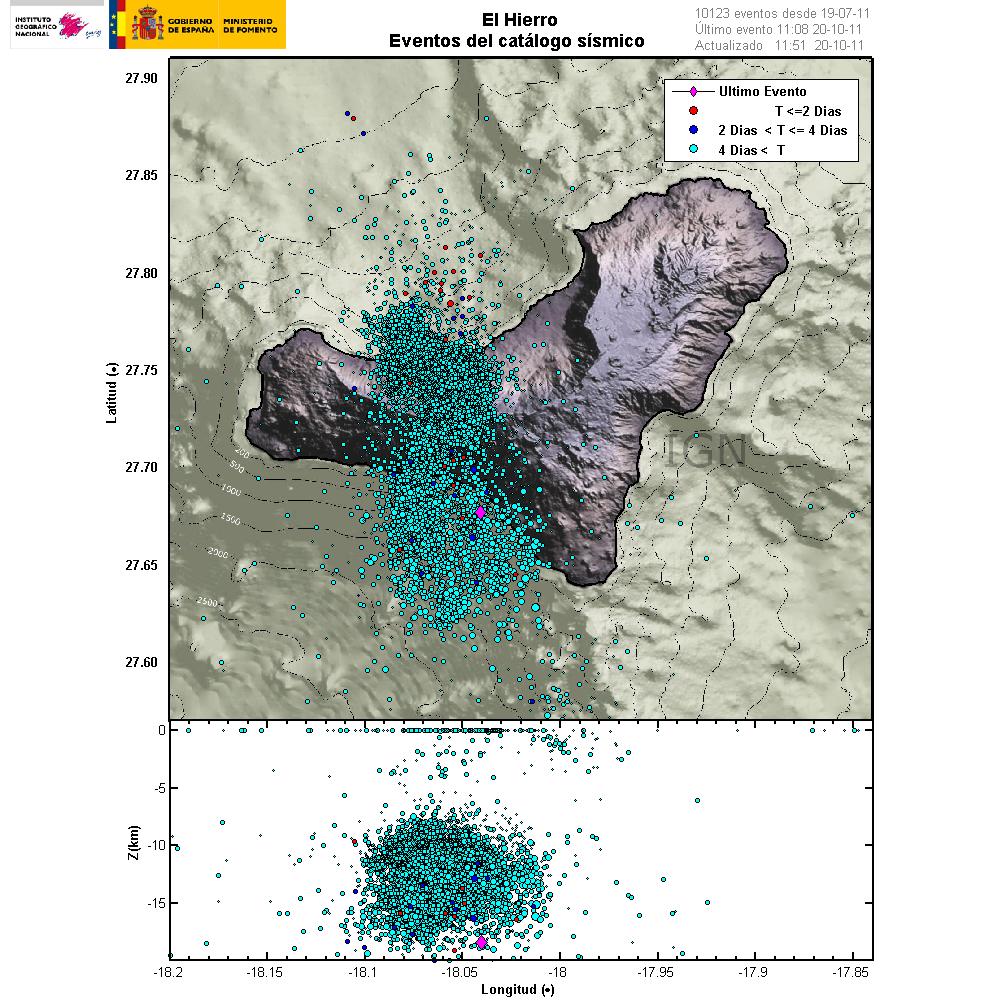
All the earthquakes that have happened in El Hierro since magma intrusions started in July 2011. This pictures clearly shows in my view the amount of magma (in terms of size, not volume) that is under El Hierro at the moment. As it is marked on the outer layers by the earthquakes. Copyright of this picture belongs to Instituto Geográfico Nacional.

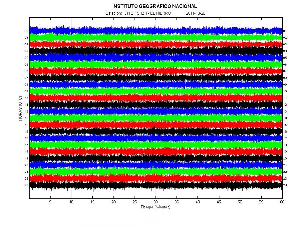
The harmonic tremor in El Hierro at midnight on 21 October, 2011. As can be seen, it fluctuates a little bit. Copyright of this picture belongs to Instituto Geográfico Nacional.
The major risk in the current eruption cycle of El Hierro is the risk that new eruption vent is going to open up nearby a human population without warning. But El Hierro has a lot of cinder cones from earlier eruption cycles. That creates the risk that a new eruption vent is going to open up on dry land without warning. But it is impossible to know when and where that might happen.
Claims that this eruption in El Hierro is going to create tsunami due to landslides are false and have no basic in fact or reality. As landslides are unlikely to happen in this eruption episode or if a eruption happens on dry land.

Ursula:
A (late) short note on the possible Spanish equivalent for “rift”.
You suggested “dorsal”, but I believe “dorsal” better applies for “ridge”.
Rift, both in Spanish and Portuguese is kept in its original English form, sometimes with an “e” at the end: rifte; but it is many times erroneously translated as “falha”, which would rather mean “fault”.
Ridges, rifts and faults zones often run parallel to each other, hence the confusion.
Thanks Renato, this is really useful. 😀
Thanks to you, Ursula.
I feel embarrassed when I think of geological names in English, not aware of their equivalents in my own language.
Even in Spanish I can do a better job, since “lusophone” volcanism and correspondent literature is so scarce (Azores being an exception).
And, probably soon, in Icelandic too… (soda, gos, hraun, eldafjallaösku) 🙂
Obs: “falha (PORT.) = “falla” (SP.)
New blog post about El Hierro eruption is up! 🙂
http://www.elhierrodigital.es/
About: reading GPS graphs correctly
I will probably make a fool of myself now but still I have to ask this. I try to understand the graphs at
http://www.01.ign.es/ign/resources/volcanologia/html/deformacion.html
including the graph of the secret station FRON-IH04.
How can you see if the station moved horizontally or vertically (or both)?
Please don’t laugh.
From these charts, I don’t think you can tell, they are only showing the change in the distance from one of the stations – the FRON.
There’s two options for this mathematically, depending on how they produce the charts:
1. either they calculate distance from FRON only in x,y (lat,long) plane and then there is no elevation info at all, it is just horizontal change that is plotted.
2. or they calculate distance from FRON in x,y,z and then elevation is in the distance implicitly, but change in elevation is not directly related to the change in the distance and you can’t just see it from the graph.
What IGN does, I am not sure, because they don’t specify it anywhere (or at least I haven’t seen it anywhere), but I think it probable that these graphs show only 1.
It is more normal (or well, we are spoilt by IMO) to show changes in each coordinate separately, i.e. in N-S direction, in E-W direction and in elevation. But that is not the case here.
Hope this helps?
Ursula, I am quite certain that the GPS gives x, y, z co-ordinates like the Icelandic. But, IGN has chosen to show it as combined motion (probably combined measure of all 3 co-ordinates). Why? Because a landslide is after all the most likely reason for a geological event that could kill people, not volcanos. At least this was the case untill recent.
Lurking have devised a way to “gleen” out the up component of the data from both the IGN GPS:es and the Nagoya GPS:es. His way to do that is so bloody ingenious that I have a problem understanding (not how he does it) but how the hell he came up with it. I could never have come up with it in a million years, and then I have worked with locationing for many years after I got my ph.d. in Physics. His mind works in a very unusual and brilliant way. It is dark arts magic we are seeing on a very high scale in his elevation plots.
Carl: I’m very proud of all “our” genius over this blog. Lurking is a Michelangelo, and you also deserve your place among the stars(surely not in one of “those” blogs).
The sad part is that my love for volcanoes stumbles upon my hatred to Maths and graphs of all sorts.
That’s the main reason why I quit Biology for Theatre, and here I am, trying to cope up with the mysteries and marvels of those GPS graphs.
Oh, but volcanos are a part of The Greatest Play of them all. The story of The Great Blue Marble that hurtles around a Golden Ball of Fire among a Field of Shimmering Stars, Nebuleae and Voids of Gravity Shimmering in all frequencies of radiation, all to a back-note of The Mighty Chord as the ultimate protagonist, The Universe, was born with a scream that ecoed across The Universal Computing Multiverses. And on that Clear Blue Ball the greatest thing exist built from the simplest rules of Creation, far simpler then the rest, but out of its simplicity comes the highest order of complexity, Intelligent Life trying to understand it’s own role in The Greatest of Plays.
And to understand a Great Play you need an actor in the cast to bring order to the Rowdy Bunch.
@Carl, Your writing style reminds me quite often about that of Douglas Adams.
Lurking got the data from Professor Takeshi Sagiya: http://www.seis.nagoya-u.ac.jp/sagiya/Sagiyas_Page/Canary.html
And I am not laughing as I managed to misinterpret these. Check directions against avcan.org.
Steaming crater in Eyjafjallajökul last sunday:
http://www.facebook.com/photo.php?fbid=2363561302589&set=a.2363538342015.125381.1657071051&type=1&theater
not available/ viewable by me
http://www.diarioelhierro.es/t26496/pag02.asp?BD=CABILDO&id_registro=140349&Id=26496&BDi=INICIO&Md=#cmt