
This is the Friday update for Bárðarbunga volcano eruption.
During the past 48 hours total (when this is written) of 69 earthquakes with magnitude of larger than 3,0 have happened in Bárðarbunga volcano. Total number of earthquakes in that same time period is 286 earthquakes (when this is written). Since yesterday it appears that earthquake activity is increasing in Bárðarbunga volcano at the moment, there is minor fluctuation in activity every few hours. I do not know why that is happening.
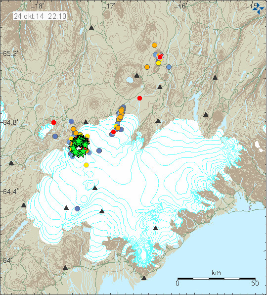
Earthquake activity in Bárðarbunga volcano. Green stars are earthquakes larger than magnitude 3,0. Copyright of this image belongs to Icelandic Met Office.
Most of the earthquake activity is taking place in North-east part of Bárðarbunga volcano caldera rim. Few to no earthquakes are happening in the centre of the caldera. Currently the caldera continues to lower around 30 – 40cm/day according to latest news from Icelandic Met Office. Far as I know the eruption in Holuhraun continues at the same rate as yesterday with no major change taking place. Some minor earthquake activity has been taking place along the dyke for the past 48 hours. Other then this I don’t have heard any other news about current status. I am currently looking into few details about what might be happening, but I am as always waiting to see what nature does next.
Added: I forgot to mention that Holuhraun lava field is now 63 square kilometres in size. It doesn’t grow in size today as fast as it used to do. It might however be adding volume rather then size at the moment, with occasional break in the lava rim allowing it to expand slowly.
Donations: Please remember to support my work by donating or by using Amazon to shop. Please just choose your region in Amazon Webstore site if I don’t have banner from you area up. Thanks for the support.
Other: Next week I move to a different schedule since current phase is not changing a lot between days. This means that updates are going to be on following days. Monday, Wednesday, Friday. Unless there is something new happening then I am going to update right away with newest information. I never know what is going to happen so I don’t keep tight schedule on updates.
Article updated at 22:51 UTC.
Both Cam1 and Cam 2 are currently very clear.
The lava now clearly only flows from the right hand side of the fissure.
The dyke is now straight and only flows to the left hand side not both.
In my opinion, in the last hour it has not looked as active as it did 2 weeks ago.
I don’t understand this: “The dyke is now straight and only flows to the left hand side not both.”
What do you mean here?
Hi IngeB (answer to 14).
Sorry I may have confused you as I could well have got my terminology wrong as I am just an interested observer.
A couple of weeks ago on cam2 the glowing lava looked to traverse both to the left hand side of the fissure and slightly to the right. This was when the fissure was looking more violent than it currently is.
2/3 Of the way to the left of the screen the looked either to zig zag a bit or was wider? If anyone could explain this to me I would be most interested. Thanks.
I see, this is perhaps also a problem of giggle etc …
The lava stream not seldom is bending. To the left of the Cam1 anyway, you would see lava meeting the river and producing more steam.
The lava / magma arrives in pulses, also the degassing is not always the same, I think that is what you mean by “more violent”. The pulsating seems to be different over the day, but also from day to day. It can be seen eg. in this video: http://www.youtube.com/watch?v=DTtL1eISdt4#t=45
Friday
24.10.2014 22:28:27 64.676 -17.493 9.3 km 3.9 99.0 4.3 km NNE of Bárðarbunga
Friday
24.10.2014 22:08:46 64.683 -17.505 10.1 km 4.0 99.0 4.8 km NNE of Bárðarbunga
Friday
24.10.2014 21:56:56 64.617 -17.505 9.9 km 4.2 99.0 2.8 km SSE of Bárðarbunga
Seems like there is an infusion of fresh magma at depth,with those quakes down around 10 km deep?
I don’t recall if this has been posted, or not. I wonder if it might shed some possible light on Iceland’s magma plumbing . . . even though we supposedly aren’t dealing with a SUPER-VOLCANO on Iceland.
.
.
Date:
September 21, 2009
Source:
Southern Methodist University
.
.
Welllll . . . my rusty html coding didn’t work out so I’ll try it without it:
.
Date:
September 21, 2009
Source:
Southern Methodist University
.
.
= = =
quote
“A rare uplift of the Earth’s crust in the Sesia Valley reveals for the first time the actual “plumbing” of a supervolcano from the surface to the source of the magma deep within the Earth, according to a new research article reporting the discovery. The uplift reveals to an unprecedented depth of 25 kilometers the tracks and trails of the magma as it moved through the Earth’s crust.
. . .
“What’s new is to see the magmatic plumbing system all the way through the Earth’s crust,” says Quick, who previously served as program coordinator for the Volcano Hazards Program of the U.S. Geological Survey. “Now we want to start to use this discovery. We want to understand the fundamental processes that influence eruptions: Where are magmas stored prior to these giant eruptions? From what depth do the eruptions emanate?”
end quote
= = =
Welllll . . . my rusty html coding didn’t work out so I’ll try it without it:
‘Rosetta Stone’ Of Supervolcanoes Discovered In Italian Alps
.
Date:
September 21, 2009
Source:
Southern Methodist University
.
http://www.sciencedaily.com/releases/2009/09/090921093600.htm
.
= = =
quote
“A rare uplift of the Earth’s crust in the Sesia Valley reveals for the first time the actual “plumbing” of a supervolcano from the surface to the source of the magma deep within the Earth, according to a new research article reporting the discovery. The uplift reveals to an unprecedented depth of 25 kilometers the tracks and trails of the magma as it moved through the Earth’s crust.
. . .
“What’s new is to see the magmatic plumbing system all the way through the Earth’s crust,” says Quick, who previously served as program coordinator for the Volcano Hazards Program of the U.S. Geological Survey. “Now we want to start to use this discovery. We want to understand the fundamental processes that influence eruptions: Where are magmas stored prior to these giant eruptions? From what depth do the eruptions emanate?”
end quote
= = =
trying to get rid of the red underline, now. LOL.
There is a help on using html codes below the comment box. There is also a link there to more information on how to use html codes in WodPress.
I can fix the codes in your comments if you want to. 🙂
Was trying to follow the instructions. . . . used to be a little good at html coding, as well. Anyway–it’s not worth your bother, imho. Just delete the first one.
Thx for your kind reply. I always appreciate hearing from you.
Large earthquake appearing on my geophones at the moment. It is from Bárðarbunga volcano. It is clearly larger than magnitude 5,0.
That sounds a bit ominous, for some reason.
It sure seems unlikely to me that all the recent upticks in 3+ magnitude quakes would result in no big deal. I’m skeptical that the ‘system’ can handle ALL THAT moving and shaking and still maintain business as usual.
Is my speculation off the wall or reasonable?
All y’all:
Muzzy has an interesting ‘video’ of Bard’s caldera ‘ridge’ and quakes happening around it here:
https://9296e9374acde5b4f42be4ab61d16a0fe4f8e937.googledrive.com/host/0B4z7bEYG56MqdTNpb0l5SnpuekU/CalderaAni3.gif
Jon, what happened with that large earthquake you caught on your geophones?
Date & time: Sat, 25 Oct 01:48:41 UTC
Magnitude: 5.0
Depth: 10.0 km
Epicenter latitude / longitude: 64.71°N / 17.49°W [Map]
Nearest volcano: Tungnafellsjökull (9 km)
Primary data source: GFZ
Je me demande bien pourquoi cet EQ de 5.0+ apparaît seulement 2.4 sur le site IMO ?
Est-ce suite à une correction humaine de la lecture automatique des appareils ?
Il en manque encore peut-être pas mal de tremblements de terre depuis minuit sur le site IMO. C’était la même chose hier, et je crois que c’est pour deux raisons: 1) les tremblements sont manuellement correctés comme vous dites; 2) c’est le week-end et IMO doit épargner de l’argent, donc éviter les heures supplémentaires quand il n’y a pas de crise spéciale. Hier, durant la journée, un tout tas de tremblements sont apparus sur les charts peu à peu.
(There are still – perhaps a lot – quakes not yet on the IMO plot since mid-night. This is the same as yesterday, and I think it is because of this: 1) The quakes are manally corrected; 2) it’s week-end and IMO has to save money, so they’ll avoid additionnal working hours as long as there is no special crisis. )
Merci de votre réponse.
Je vois d’ailleurs que maintenant, la magnitude a été portée à 5.2.
New satellite picture of Bárdarbunga and Holuhraun on Twitter.
(retweetet on @gislio/Bardarbunga, 16hrs ago).
This one:
https://twitter.com/edwinbul/status/525731035934625792
So sad it is not near enough…
You can download a 7,3 MB zip-file with a high resolution image from here:
http://earthexplorer.usgs.gov/download/options/4923/LC82170152014297LGN00/
– click on the enabled “Download” button
I hope this is not a temporary link.
Did you see something at the caldera? I’m not sure…
November’s issue of Nature Geoscience will carry a numerical modelling paper on the long-term evolution of the Icelandic “hotspot”, which is now accessible online at:
http://www.nature.com/ngeo/journal/vaop/ncurrent/full/ngeo2264.html
Unfortunately it is behind the Nature.com paywall, but Figure 2, which is visible, indicates that the Bardarbunga – Kistufell area overlies the thickest crust (>40km), and the hottest and most buoyant part of the underlying Icelandic mantle plume.
Re. the crust under Iceland: http://www.geotop.ca/pdf/darbyshireF/Darbyshire_et_al_EPSL_2000.pdf
Saturday
25.10.2014 12:10:33 64.674 -17.444 4.7 km 4.7 99.0 5.5 km NE of Bárðarbunga
Does anybody else get the feeling this could really end with something of an anti-climax? Obviously this is from and eruption point of view.
I have this feeling that things are slowly just going to die down now.
yesterday we had the highest number of ü3 quake in 48 hours since the start of the event! the outbreak of the column has hardly gone back in recent weeks. it looks even afterwards from the new magma enforcement. think it is still far from closure!
We cannot but try to do our best to make this main event a huge commercial success.
I think this would have to be on another blog! 😉
Yes this episode could fade out,but the system is probably going to to be more active going forward then it has in the more recent past.
tremor seems to be climbing rapidly:
http://hraun.vedur.is/ja/oroi/skr.gif
Don’t know if this has anything to do with it, but there is another storm in Iceland, esp. in the southeastern part. http://www.vedur.is/vedur/spar/thattaspar/#teg=vindur
A good site to view high definition satalite images
https://earthdata.nasa.gov/labs/worldview/
I am wondering about the cooling effect of bb’s SO2 on mean temperature above 80 degree latitude. Any thoughts ?
Local warming of the stratosphere in the northern hemisphere regions could alter weather patterns, most likely increasing higher pressure over the arctic regions where high levels of SO2 are present.
I’m not sure how high up and how much of it is there but the SO2 has exceeded 8000m according to satalite data – so some is now in the arctic stratosphere.
In winter there A: Won’t be much impact because there is no sunlight to block at that latitude and B: the SO2 in the troposphere is quickly removed by rain and snow. At high latitude in winter SO2 might have a WARMING impact rather than cooling. There is some research that shows tropospheric SO2 could increase cloud formation. More clouds in the winter in the polar region would prevent radiation into space possibly keeping temperatures slightly warmer.
Fair point there, yes there is very little sunlight in the arctic during the winter, however high SO2 levels are being recorded all over the northern hemisphere 50 degrees north and have been doing so since the early weeks of this eruption. I was up until a week ago monitoring it, however the website is currently not loading on my phone so I haven’t been able to check.
It should also be remembered that the beginnings of stratosphere in the northern latitudes is much lower then the tropics, around 8000 meters. During the winter months it can drop a little lower. Also weather conditions can allow for the pollutants such as SO2 to rise higher into the atmosphere.
I’m not saying it will or it will not have an effect, but it is a relatively unstudied area. I’m sure the scientist are currently studying this event now, but it could be a few years before data & research conclusions are released.
Warming in the arctic atmosphere during the winter often leads to higher pressure. This in turn can alter the polar vortex resulting unusually extreme conditions in the mid latitudes.
There should be explosive eruptions before the SO2 would arrive at heights of 8.000 m and above.
At the moment, the gas is not much higher than 2.000 – 3.000 m as I remember from a report about one of the overflights.
You will note that the emissions from Iceland are still considerably below the emissions from Nyiragongo in any given week. That volcano dumps a huge amount of SO2 into the troposphere. What is the problem would be a stratospheric injection and that won’t happen without a very explosive eruption. But again, tropospheric SO2 washes out quickly. Once the emissions stops, the atmospheric SO2 begins to immediately and rapidly decline.
There is a pattern I think here where the swarms seem to alternate between tung & Herðubreið whilst barda remains active at all time. I say this now as activity toward tung is picking up whilst Herðubreið is petering out. I will be watching the next 72 hours with great interest.
According to mbl.is the lava field is now expanding more to the east. Satellite image can be found here.
http://www.mbl.is/frettir/innlent/2014/10/25/hraunstraumurinn_til_austurs/
The interviewed scientist (Thor Thordarsson) thinks btw. that the eruption in Holuhraun could still continue for a rather long timespan. It could just stop, if the lava producction were under 3 m3/sec. But at the moment the eruption is still producing between 50 and 100 m3/sec. – Which means nevertheless much less production in comparison to the beginning, when it was around 1.000 m3/sec.
IngeB…
The SO2 does not require and explosive eruption to reach altitude, it can do so easily through atmospheric conditions.. besides the column itself has reached heights of 5000 meters at times.
Unfortunatly the NOAA satalite data website i have used for the 5000 meter levels is down. However here are the 8000m levels from NASA…
http://so2.gsfc.nasa.gov/pix/daily/1014/iceland_1014z.html
thats from just a few days ago, as you can see there appears to be a fair bit floating around at 8km
http://so2.gsfc.nasa.gov/pix/daily/ixxxza/loopall_omps.php?yr=14&mo=10&dy=14&bn=iceland
Anyone else see a rising pattern on http://hraun.vedur.is/ja/vatnajokulsvoktun/von1_trem.gif
in recent hours?
Maybe the storm?
There does not seem much deviation from recent activity on that chart and recent activity is non eruptive.
Red line had dropped a bit from mid day 23rd to mid day 24th, but is now back up to where it was.
Blue and green hint at a rise over tha past 6 hours or so.
Spikes seem to occur whenever there is earthquake noise on the drumplots in any six or more minutes out of eleven consecutive minutes.
So2 at ant level will dry the air by increasing precipitation. Although high level aerosols are effective at reflecting sunlight, dry air at low levels will allow surface temperatures to plummet. This has happened here in switzerland over the last nights. Warm day, unually cold at night, low humidity. As a greenhouse gas water is present in percent, co2 measured in parts per million.
SO2 at the right altitude blocks solar radiation from reaching the ground. SO2 absorbs this radiation and warms the surrounding atmosphere, the warming of the surrounding atmosphere can result in more moisture hence the increased clouds. However high levels of SO2 in the stratosphere normally bring dryer weather, i’m assuming this is in part because of the lower temperatures below and higher temperatures above.
Any level
A question for Jon.
Why is it i still have to enter a CAPTCHA even though I subscribed? I entered my email address and then followed the link it sent to me.
Crosspatch..
regarding Nyiragongo, this volcano is located within the tropics, any SO2 would need to travel to twice the altitude to escape the troposphere then that from a volcano in Iceland or Alaska.
@ian did you remember to log in?
oops.
It appears i signed up for the mailing list rather then registering lol. All sorted now 🙂
You have to register to get rid of the captcha tests. You also have to remember to log-in to the blog site. WordPress is going to log you out after two weeks in automatic manner when the cookie it set expires.
okay, thanks Jon 🙂
Laki caused a severe winter in the uk. But what do i know? Ive just got in from the pub!
So far this eruption is nothing like Laki. Laki had over 100 vents, this has one. The scale of the emissions per day is nowhere near the same. That is not to say that all of this can’t change tomorrow, because it is, but as of right now there is no comparison between the to eruptions in term of scale of emissions per day.
Meant “because it can”, not “because it is”.
It is possible to do a comparison, so far this eruption is about 10 times smaller than Laki, although the difference is big, it is not huge. Holuhraun has been a very big eruption so far.
Saturday
25.10.2014 19:50:41 64.674 -17.482 3.4 km 4.1 99.0 4.3 km NNE of Bárðarbunga
New research from UC Davis and Aarhus University in Denmark shows that high mantle temperatures miles beneath the Earth’s surface are essential for generating such large amounts of magma. In fact, the scientists found that the Bárðarbunga volcano lies directly above the hottest portion of the North Atlantic mantle plume.
http://www.nature.com/ngeo/journal/vaop/ncurrent/full/ngeo2264.html
H/T http://wattsupwiththat.com/2014/10/25/study-icelands-bardarbunga-volcano-sits-on-a-massive-magma-hot-spot/
Interesting name. Italian prog rock fan?
Not even close. Abiogenesis or biopoiesis is the natural process of life arising from non-living matter such as simple organic compounds. Probably more likely than alternative theories of creation. However, if Bárðarbunga is getting its lava directly from a hot plume rather than just a magma chamber, then as postulated, “From time to time the Earth’s mantle belches out huge quantities of magma on a scale unlike anything witnessed in historic times,” Lesher said. “These events provide unique windows into the internal working of our planet.”
Such fiery events have produced large igneous provinces throughout Earth’s history. They are often attributed to upwelling of hot, deeply sourced mantle material, or “mantle plumes.”
We could be in for a long volcanic event. Read the article.
This twitter robot posts earthquakes automatic on twitter. The text is in Icelandic.
https://twitter.com/jardskjalftar
And actually, on average, I think we are matching Laki here.
The Caveat is that Laki started much stronger, then faded to a weaker eruption for a very long time. This one may still be young, and fade as well, which would lower it’s “average”. Hence comparing average daily outputs now isn’t appropriate.
Anyway, it’s not just about volume of SO2 output anyway. As has been said, Laki had explosive eruptions at times, which resulted in stratospheric injection, which then spreads over a greater area and lingers longer. Time ofyear has an affect as well. If climate effects are due to reflecting solar radiation, would it not matter that right now, there’s very little solar radiation to reflect to begin with where high levels of SO2 are present?
Laki came in *pulses*; one part of the crater row would erupt, very violently for a certain amount of time, then shut down, and another part erupted… this happened several times over the course of several months.
Holuhraun has never come anywhere close to the rate of any of the phases of the Laki events – but it does seem set for a long steady continuous eruption, thus far anyway.
We might be in for something similar, if Holuhraun shuts down, something might start up elsewhere in the fissue rift, but hopefully not under the ice cap.
To me, it seems most likely that scenario #1 is going to play out, Bardarbunga settles down, and the fissure eruption gradually subsides. Also interesting, is that hints of this event were given in the earthquake swarms back in the 1996 Jökulhlaup, the dike fissures from Bardarbunga went towards Grímsvötn instead. I suspect that major rifting diverted the branching, making a sudden turn at 25 deg NNE into what we see today, and it is fortunate that the lava came up in an ice free plain.
Future events most likely will involve more lava flows into the Holuhraun area.
Mike is right. Holuhraun is nowhere near Laki.
Please look at the facts, Patrick.
Lava field is many times smaller. Laki was 60km long, 60km width in a few spots. Holuhraun is 20km long, 4km wide.
Lenght of vents is many times smaller. Laki was a semi-continuous fissure 30km long. Holuhraun was 1km at most.
SO2 emissions have been significantly lower. Laki just killed people and sheep. Thick haze covered Iceland and Europe. Holuhraun makes you couch, and just ocasisonally. Words of a local.
Haze from Holuhraun occurs in Iceland but only at times, and never got as thick as reported for Laki. Laki was a complete disaster. Holuhraun is at times an annoyance, but only has killed a few birds locally, nothing else.
Laki volume was 15-20km3 on 6 months (average 3km3 per month). Holuhraun has been about 1.5km3 in 2 months (average 0.75km3 per month).
These are the facts.
Holuhraun is the largest eruption in Iceland since Laki, but it’s not the same scale, that’s for sure. It is about 5 to 20 times smaller.
Ok, you can say it’s something like 10 times smaller. That’s a more correct statement.
But it is still a very BIG eruption.
The lava field of Holuhraun is WAY larger than many other lava fields in Iceland. But, there are many lava fields in Iceland with same size as Holuhraun, and nearly everywhere on the island. And Laki is a WAY larger lava field in Iceland, which is on its own WAY smaller than the epic Thjorsáhraun lava field.
Things in Iceland can be like this, just to be a bit poetic:
small around o.01 km3, this is Fimmvorduhals
medium around 0.1km3, this is Eyjafjallajokull or Krafla
big around 1km3, this is average Katla or big Hekla lavas
very big 1-5km3, this is Holuhraun, some Reykjanes floods, several small shield volcanoes
massive 10-20km3 this is Laki, Edlgjá, many shield eruptions
epic 20km3 or more, this is Thjorsáhraun, maybe some of the largest Icelandic shields
beyond epic 100km3, not existing in Iceland, think Siberian traps
I feel very small when I write this, and remember the scale of these lava fields. Every time I go see them, even with being the 100th time I am there, I still get impressed by their vast size.
Holuhraun does impress me a lot! 20km lenght is huge! It is just a sheer impressive vasteness.
But it does look small compared to Laki. Which runs 60km in a couple directions. As wide as the eye can see, and beyond that.
And Thjorsáhraun makes my mind just go berserk. Simply I can’t look at its end on the horizon. Even from the top of a mountain. Runs along 150km lenght or more. I must drive for hours from one edge to the other, and you drive good road.
I wonder if we are doing ourselves a disservice by constantly referring back to Laki. It seems like we might be acting like Generals who consistently fall foul of assuming that the next war will be the same as the old one.
It seems that we are not going to have a Laki style event at this stage (thank God) so there is already an element of redundancy in any comparison.
But more than that, the event is hardly over, an probably won’t be for several months, so any comparison between an finished event like Laki and an unfinished event like Bardabunga, at this stage isn’t very useful. We could be like Generals comparing the First and Second world wars in March 1940, or Generals comparing the the World War 2 and the Cold War, on October 16 1962. And in both cases it would have turned out that they were not comparing like with like, and the results of all three events were so dramatically different as to barely support comparison.
Until the event is over, and BB either erupts, or the activity slows to the point where we can all draw a big sigh of relief, we won’t be in a position to properly compare events.
Peter,
We already have a Laki *style* event; that’s been pretty clear from the start. This is a regional event, a rifting fissure, driven primarily by tectonics – the regional stress field, exactly like Laki.
What we do NOT have is a Laki *scale* event; the dyke is narrower , the rifting is on a smaller scale, and only a small part of the dyke has made it to the surface. Yet, anyway!
BTW Irpsit: It is not possible to look at Thjorárhraun from end to end , a) because there are some mountains between its supposed origin (which in itself is not really certain where it would be), b) it is (probably, see above) about 200 km long, c) esp. because it is covered by other lavas and tephra layers for a big part of this length. http://en.wikipedia.org/wiki/%C3%9Ej%C3%B3rs%C3%A1_Lava
Sorry, meant Þjórsárhraun, also called Thjorsa lava or Þjórsá Lava, the biggest known lava field in Iceland.
Do you think when looking at the way volcanic eruptions can affect the climate we should look at other factors too. For example in the cold winter of 1783/84 I believe the North Atlantic Oscillation was in its negative stage, which makes the west colder. There was also an El Nino underway which further complicates weather patterns. In fact, I have read that some scientists think that Laki should not be blamed for the cold weather at all as we were already in a ‘Mini Ice Age. I do not really know enough to have a definite opinion but wondered what others on the site thought.
Thor Thordarson etal. on the climatic impact of the Laki eruption: http://climate.envsci.rutgers.edu/pdf/Schmidt2012JD018414.pdf
They also say that there are still a lot of questions open or not really well answered.
And it has to be emphasized that this event at the moment is really just about a 10% part of what the Laki eruption was.
Yes Inge, Let’s not compare with Laki. Let’s just say it’s Laki sort of game, but a minor version.
Let’s just reinforce the wording like “a regional rifting event”
They only happen every 120 years or so.
But sometimes a couple of these events come separated by a few years.
And I think the climate impact of Laki was a combination of factors, just like Tambora iu 1816.
Very low solar activity, mini ice age (probably also driven by established climate patterns and oceanic currents), the volcanic eruption itself
Krakatoa was an interesting example. A very large eruption and there was climate impact but not as dramatic as Tambora, since the climate was already warming.
So if a very large event would occur now, it would have an impact but not so dramatic because we are still in a warm period.
Just see this: no large volcanic eruption, rather very low solar activity, but oceanic currents and CO2 forcing make the warm period continue. Solar activity has been steady decreasing since the 1950s and it’s for the first time since Tambora at very low levels, but not yet at the same bottom level.
And let’s be clear, it is not just CO2. We have a lot of other human interfeering factors. Incredible widespread deforestation affects the control of atmospheric balance and even albedo, destruction of ozone layer, and many other polluted greenhouse gases, some MUCH more powerful than methane CH4. And of course also other manmade aerossols that reduce global temperature like SO2 and others.
Examples: Carbon tetrafluoride, Perfluorotributylamine, Trifluoromethane, Sulfur Hexafluoride, Hexafluoroethane
Most people just talk as if it would be just a question of solar activity versus CO2. And sometimes CH4 is added to the question. No, there are many other factors.
Are you aware there has been no warming for 17 years?
Interesting, except you brought the Lysenkoism into it. Anthropogenic Climate Change (renamed from Anthropogenic Global Warming after the inconvenient truth that we are in a cooling phase from shifts in various multi decade weather patterns (that had previously been warming), the sun’s output was dropping and cloud formation was increasing) has always ignored data that didn’t fit its conclusions. Little facts like GHG levels *postdate* temperature highs in the geological data. By centuries….
thanks folks, really interesting info
A 5.1 recently.
5.4 on Geofon, Potsdam; we’ll see after the manual updates.
Now it is at IMO with 5.3 at 0,8 km.
Irpsit, you say you feel small than seeing the lava fields. I am in awe just reading about them – as in the way you speak about them too. It is the first time I have ‘followed’ a volcano and read up as much as I have.
What a wonderful miCraculous world we live in.
The biggest lava fields of the Laki eruption are called Eldhraun und located between Mýrdalsjökull (Katla) and Lómagnúpur. You can see them on a webcam also called “Eldhraun” by the Icelandic Road Administration (Vegagerdin) near road 240: http://vegasja.vegagerdin.is/vefmyndavelar/?xmin=488641&ymax=514920&xmax=765811&ymin=318000
There are also lots of photos on the net, eg. on Wikimedia: https://commons.wikimedia.org/wiki/Category:Eldhraun
Thank you.
than? Where did that come from? A troll maybe. A When troll in hiding.
Lets hope its not BB just clearing his throat! I wouldnt like to be in the way when he finaly spits it out!
Ref the 5.3 EQ earlier…is this unusual being that it happened ESE of Bunga? Usually all the big quakes are in the NE area?
Combine the unusual location with the silence following.
No +2M events anymore since this event, tremor went down.
Is something blocked in the exit of the main chamber?
GPS measurements do not show any difference yet, but this again shows we still needto learn to read these fast responce measurements of subsidience.
At the moment, I think, we can’t take too much into account the earthquakes indicated on the usual IMO plots. We saw this also during the last days, there is not a lot of personnel there at the moment (weekend), so checking takes more time. I think they always start with the smallest quakes (volcanic ones?), then continue with the biggest ones (caldera subsidence) and the quakes of medium magnitude come last, because I imagine they are not so important. There’ll most probably a lot more quakes appearing one by one in the course of the next hours on the IMO plots like during the last days.
So it’s better to wait a bit til we try an interpretation. 🙂
It must be above the intrusion. More magma leaving the caldera and entering the fissure?
http://en.vedur.is/earthquakes-and-volcanism/articles/nr/2949
IngeB
I base my questions on the automatic detection and the drumplots
On the strange peak we had some days ago: could this have been a measurement falsification due the high solar activity?
Mike: I have long want to ask you one question. We both agree, and there seems no doubt, that this is a regional event, driven by tectonics, where rifting occurs along a great lenght, which is the first since Askja 1875 and possibly second after Laki.
But I have long asked myself this question:
– In Iceland we see evidence (in dead zone especially) for very long dikes and fissure eruptions. Between 20 and 50km long. Dikes are up to 100km. Not only in dead zone but in other spots ocasionally. In the west volcanic zone, fissures can be up to 10km long, but rarely konger than that. Why there are so prominent in the dead zone, it bugs my mind.
– Second question is in those regions where very long eruptible fissures do not occur, very large shield eruptions occurs. For example, south of Langjokull or north of Bardarbunga and further north of Askja too. Fissures are minor, usually not longer than 5km, but massive shield volcanoes occur abundantly. Why?
Dikes are still very long, driven by the same regional tectonic historical events. For instances ver long dikes seem to have sprung from Askja northwards into some shields, or from Hengill northwards into Skjaldbreidur shield. Often the rifting goes right up to the surface but only erupts at a single vent at the terminus of the dike.
Same for Bardarbunga (Trolladyngja) and by the way Holuhraun.
I get so often this question in my mind everytime I hike and drive by these regions, either of long fissures or large shields, but never both at same time. There are certainly differences in the tectonics driving them. But I don’t know why.
Why? Why only a single vent? Why dike only erupts at tip? Often forming a shield volcano. This is the case in Holuhraun and around.
And while in dead zone, it unzips all the extension. Why? And there are no shields. This is the case of Laki.
What are the differences in tectonics driving a dike to erupt in long fissure style, or in shield nearly one single vent style?
I know it’s Mike you want to answer, but if I might observe from the fault map –
http://upload.wikimedia.org/wikipedia/commons/9/90/Volcanic_system_of_Iceland-Map-en.svg
If, before Iceland formed, the mrt were a relatively straight line then the stresses would be fairly equal, but as the plume (theory I know) intensified and pushed magma to the surface, the magma did not pan out evenly, it intensified to the SE of the mrt as it was then.
As it pushed up and created new land it predominated the SE push and the fault ‘kinked’ and went with it, giving us the fault we have today. Because it is knked and not straight, the situation that now occurs when the normal mrt either side of Iceland starts activity, is that the fault wants to react to mrt stresses but the fact that it kinks makes it impossible for that to happen so some area get pulled, or pushed, or slide against each other creating these different results.
Just my simplistic idea of it.
@Irpsit. I am not Mike Ross neither, but I think these questions are interesting.
I think it has to do with the rift jump. The MAR is reacting in Iceland to the Northamerican Plate moving (a bit) more west than the Eurasian Plate is moving in eastern direction. And to hold its position over the hot spot, it has to jump to the east. It has done this often before, last about 7 mill years BP.
And this is the reason IMHO why the volcanic systems in Reykjanes are rather short, arranged en echelon and at an about 30% angle to the rift itself, whereas in the presently upbuilding part of the rift, ie. the Eastern Volcanic Zone (EVZ), they are more or less aligned acc. to the rift and there is not so much pull to the east, so they can be longer. This could then be the reason why the Bárdarbunga system is the longest one in the whole of Iceland and the Askja system more or less also of the same length.
Also the EVZ is the youngest of the volcanic zones of Iceland, perhaps this explains also its tendency to fissure volcanism and not to such sort of locally concentrated one as is usual for shield volcanoes. Which btw. are not always just built up from single vent eruptions, see eg. Kilauea (with the caldera and Puo’O and the Eastern Rift Zone) or the (parasitic) cone rows on the flanks of the shield volcano Skjaldbreidur near Thingvellir.
@Scots John, I actually don’t understand one abbreviation you used. What is “mrt”? Could you explain please?
Scott and Inge,
I don’t mind your answers. In fact I would also like to hear Jon replying on this one too.
You both gave me very self-explaining answers. I read your reply Inge first, and I visualized very clearly the interaction between the MAR faulting (with the NorthAmerican plate moving more west than the movement east of the European plate) and the “fixed” plume.
Inge: Thus, I might assume we might see not only a track of the hotspot from Snaefellsnes until Bardarbunga, but also another shorter and older track coming from the eastern ou southeast direction inside the European plate.
If I can hypothesize one such track I would say Oraefajokull to Bardarbunga?
Of course I know that many researchers have spectaculed instead that that might be the next jump of the MAR trying to catch up eastwards. But then, as the European plate also moves (a bit) east relative to the plume, we shoud see a older track further east or SE, from Bardarbunga, which is the current hotspot fixed position.
Still I don’t yet understand clearly why north of Bardarbunga shield or single vent volcanism becomes dominant, while southwest it is more long fissures. Because wouldn’t the rifting north of Bardarbunga be just as young as the volcanism southwest of it?
But I think your explanation Inge, is quite spot on.
You see the tendency of Reykjanes to try to move quickly east as it transitionates to SISZ and then the dead zone.
One more interesting thing. Another mystery:
At around Dyngjjokull latitude, all the dikes shift in orientation from SW-NE to S-N, all at same latitude, includign the present one, but also many Pleistocene dikes exposed in the east fjords, millions of years old. Quite interesting no?
On the NVZ (Northern Volcanic Zone): http://www.ldeo.columbia.edu/users/menke/b96/newdraft/
It built up about 6-7 mill years ago when the older Húnaflói-Skagi northern rift zone went extinct.
@Irpsit,
“Still I don’t yet understand clearly why north of Bardarbunga shield or single vent volcanism becomes dominant, while southwest it is more long fissures. Because wouldn’t the rifting north of Bardarbunga be just as young as the volcanism southwest of it?”
Could it have to do with the strong local stress field of Askja? In other simple words: Boom = ho.
I don’t think, it is possible to say that shield volcanoes are dominant north of Askja. There are a lot of faults and fissures, like eg. in the systems of Krafla and Askja. But there are also a number of shield volcanoes there and you won’t find any south nor southwest nor southeast of Vatnajökull. On the other hand, some scientists say, that the tuyas would be the subglacial counterparts of shield volcanoes and there could some be buried under Vatnajökull glacier.
The Icelandic shield volcanoes are dating from interglacials (Ice Age) or from the epoch of increased volcanism at the end of Ice Age (about 9.000 years ago). I think they are sign of an increased magma production (decompression melt).
When the rift jumped from Snaefellsnes to the east, 7 mill. years ago, it did only activate the WVZ (Western Volcanic Zone), as I read somewhere, the Eastern Volcanic Zone was activated only about 3 mill. years later. So that this would really be the youngest and less evolved part of the now active rift in Iceland.
Brilliant post, Irpsit. My take is that the fissures and dikes are the strings and the volcanoes are the brass.
Nice view on both MILA cams!
Is there any understanding of why there is such drop in activity following the M5,3? The are hardly any quakes taking place, I see like 4 in the last 2,5 hours none of them larger than M1,3, tremors on the stations near the fissure are all down to levels I have not seen for quite some while.
I guess the most likely explanation would be that the M5,3 has opened a new path for magma to move up. I dont think that it has blocked something, as in that case we would see an increase in seismicity due to pressure building up. But the seismicity and tremors are down, which logically should mean that pressure is signifficantly lower, so magma can rise without any major resistance now. As soon as the next resistance in the path of the magma will be reached, we should see pressure build up which will manifest with more tremors and quakes.
Would be great to hear opinions on this from the users in the know.
They are now measuring up to 21.000 μg/m3 of SO2 in Höfn in Hornafirði. The range is 9000 – 21.000 μg/m3 of SO2 at the moment.
Jon, What does that amount of SO2 tell you and/or other experts about current operations of the system?
This article gives properties of SO2, perceptibility, effects on health, and lists recommended exposure limits from many different countries’ regulations. Concentrations are given both in ppm and in microgams per cubic metre.
And here’s the link!
http://www.ivhhn.org/index.php?option=com_content&view=article&id=82
These levels are very unhealthy, and even dangerous. They cause serious respiratory symptons within a few mins of exposure is everyone.
I would say, because they are just short of accutely toxic in humans, these levels might just start to kill sheep and other small mammals if exposed for a sufficiently long time outdoors at those levels.
21000 ug/m3 is really too much. It prompts evacuation by international standards. It’s crises levels.
I was exposed to 2500 ug/m3 one day here in the south and it could not only feel the SO2 and Cl smell, but together with many people we complained of slight chess disconfort. ´
So I can’t imagine what it is to be 10 times more!
Is this gas problem getting aggravated by the onset of the colder weather?Is there any mention of the concentrations of some of the other gases?
Cold weather agravates yes.
Inversion can arise, and traps/sinks pollution downwards. Not good.
Cold weather also linked to north winds, bringing pollution to south Iceland where most population lives.
But eruption became gassier apparently a week ago. Not sure now.
No info on other gases. But when pollution haze goes very thick, you know that all volcanic gases are high, not only SO2, but also Cl, HF, etc..
This levels of SO2 are deadly, or can cause blindness or other damages to people health if they are exposed to it for a long time.
Pictures from the town of Höfn (around 2.000 inhabitants) with and without gas pollution: http://ruv.is/frett/%E2%80%9Eloftid-er-thungt%E2%80%9C-segir-ibui-a-hofn
There are also given tips about how to reduce the influence of the gas within the houses.
At the time of the interview (around 19:00, I think), they measured still about 18.500 mikrogramm/m3. This is really very unhealthy.
I understand about gas and health. That wasn’t really my question.
I’m wondering what the implications for the GEOLOGY of the volcanic system are, that it’s putting out so much of that gas. Are there such implications? There must be?
Do those levels of that gas have implications, e.g.–groping, guessing–
1. for type of lava erupting?
2. speed of lava erupting?
3. depths of lava erupting from?
4. viscosity of lava erupting?
5. vulnerability to pyroclastic effects if such lava gets in contact with water compared to lava with greatly lower concentrations of such gas?
6. lubricating capacities at various depths of magma with such a high concentration of that gas vs those with low concentrations of it?
7. Greater or lesser likelihood of violent eruptions with or without such high concentrations of such gasses?
Sorry I wasn’t clear enough before. I hope the above are clearer questions.
Thx in advance for any thoughtful answers to the above.
Here are answers to Da Xin questions.
1: This is basalt magma. See here for details.
http://www.teara.govt.nz/en/interactive/8686/types-of-magma
2: Hot lava flows faster then colder lava. Due to heat loss being quick lava flows slow down quickly as the lava stream gets further away from its source.
3: More gas means that the magma has not had time to get rid of its gas inside a magma chamber. This also means its source is deep within the mantle.
4: See answer #1.
5: When this type of lava gets into contact with water or glacier it explodes. Creating ash cloud in the process. This was seen in Grímsfjall volcano eruption in 2011. It was the same type of magma, it just got into contact with glacier and that resulted in 10 – 30 km high ash cloud for few days.
6: None. Far as I understand the physics behind magma and interactions with the crust.
7: Gas in magma does not change the like-hood of an eruption. There are other factors at work here. Violent eruption only happens (most of the time) when magma gets into contact with water or glacier.
In the case of Bárðarbunga volcano the eruption is Basalt with high gas content due the source that magma coming from a great depth (more than 100 km).
@Jon,
“When this type of lava gets into contact with water or glacier it explodes. Creating ash cloud in the process. This was seen in Grímsfjall volcano eruption in 2011. It was the same type of magma, it just got into contact with glacier and that resulted in 10 – 30 km high ash cloud for few days.”
Maybe a point of discussion:
You often see groundwater filled crater lakes. Magma-water interaction makes an eruption explosive. To possibly avoid that in case of imminence you could drain the lake. There are pumps with a capacity of up to 2000 l/s.
It makes it even more likely that the magma will erupt in the crater due to released pressure.
With all the subsidence on the NE flank. This mornings Mag 5 has equalised the Caldera for today. Ring faulting on NE, leaves the questions of it either being structurally weaker or the pressure from glacier is the most here. Very difficult to tell for sure.
The dyke has certainly chopped the foundations from this section of caldera so it stands to reason that there is a void between magma and chamber walls.
Infrared camera flyover at night would be good footage to watch. It would show more clearly were the hot spots are if any away from the lava field and fissure.
The level of SO2 is terrifying. Being a parent myself and knowing how sensitive children’s lungs are, is it enough at these levels to just put the heating on to push the SO2 out of the homes?
With the higher gas levels and the earthquakes occurring deeper,around 10km,perhaps this an indication of large intrusion of basalt in the caldera chamber?Could some of the gas be coming from the caldera itself through the glacier as the fissure has not increased in lava output and if anything has reduced in production ?
JB I think this is what might be going on. I did mention something the other night that it looked like the volcano was breathing. It could have been held under vast pressure deep within the system, or in any melt water under the glacier which could be actually saturated with gas. when any pressure is released the gas will escape just like opening a fizzy drinks bottle, or in diving IE the cause of a bend.
I think it could be coming out of any ground or glacier faults within the caldera .
Actually I was thinking of off gassing occurring around the the ring fault of the caldera,escaping through the ground,particulary CO2.Not sure what effect passing through water or ice would have on SO2,would a good proportion be scrubbed out ?
As you say JB it could be around the rim as this is where all the action is.. It would be interesting if they could some how take some measurements near the rim.
The SO2 measurements are getting very high.
On Mila one- Far left of the screen, there appears to be new intermittent activity- It is steadily getting more active though.
I am not seeing it at the moment. If confirmed this might be a new vent or a new fissure opening up. It often starts with intermittent activity.
Holuhraun eruption is going strong on the MILA 1 cam, but I can’t see anything else at the moment.
SIL station VOT shows a strange uptick in the higher Hz http://hraun.vedur.is/ja/oroi/vot.gif , though there is no storm at all in the region (more a calm) http://www.vegagerdin.is/ferdaupplysingar/faerd-og-vedur/sudausturland/sudaust1.html .
Water moving underneath?
Gígjukvísl, the river on the Skeiðarársandur, which in 1996 transported most of the water of the Gjálp eruption jökulhlaup, looks a bit interesting on a 2 month run:
http://vmkerfi.vedur.is/vatn/vdv.php?p=0&station_id=218&page_id=384&direct=1
(IMO Vatnafar / resp. Hydrology -> permit -> chose the river on the left-hand ledge)
Water height has been going down continuously from 147 cm to about 0 now. It is normal that the water diminishes in winter (melt water from the glacier), but to 0?
The conductivity of the river on the other hand, had a spike from around 80 up to 176 just some days ago (on the 19th), it was without any obvious changes for most of the time these 2 months, but has become very unregular these last days.
This is a river taking up waters from Grímsvötn – and from the direction of SIL station VOT btw.
Would be interesting to see conductivity of rivers near Höfn re. water height and gas content at the moment.
Heightened conductivity means heightened mineral content, means (somewhere) heightened geothermal / magmatic activity in the glaciers the rivers come from.
BTW: The IMO specialists says on the Icelandic IMO vatnafar (hydrology) page, that there has been a bit heightened conductivity in Múlakvísl, a river coming down from Katla some days ago, it went up from 130 to 230 micro-Siemens. This was probably geothermal waters coming from one of Katla’s cauldrons. (“Rafleiðni í Múlakvísl jókst 12. – 14. október, um 100 míkró-Seimens, frá upphaflegum ~130 míkró-Seimens. Hin stöðuga aukning í rafleiðni bendir til að lítið magn hlaupvatns hafi lekið undan einum katlanna á vatnasvæði Kötlujökuls. “)
@ Inge re: water gauge height. The height is relative to some arbitrary level in the gauge. If you look closely, you’ll see that it is actually at about minus 27cm now; but that is the height, not the flow rate.
Look at a one year period, and you’ll see heights down to -54cm last december.
As to the conductivity spikes, I would guess instrument noise, in view of all those negative spikes.
Thank you, Peter W.
It just looked like a bit strange to me.
But good to know what these negative figures mean, in the future. 🙂
But there are still the questions about the high conductivity spike on the 19th – not a very high one, but though – and the up on the VOT tremor plot. It is only to be seen on this plot, not on the others around like GRF, should it just be a local weather phenomenon?
I think that’s just breakouts at the edge of the lava flow, or possibly a poor view of the lava river on top of it.
Yep.
Yes, you can see it here:
http://www.brisske.de/Fotos/Public/index.php?AlbumDir=/Fotos/Public/2014-10-26_BB
1. pic from today
2. pic from tonight
3. pic mix from both
I think it has been reported a couple of times that there are a few vents, not just one, but only one is erupting lava at the moment. The others have been erupting gas. As the weather gets colder, these will be more obvious. So you can see intermittent plumes from the other vents from time to time and that is consistent with what has been reported over the past several weeks.
How odd. It’s almost as though the pressure, whilst isn’t being released, is transferring to another position closer to the lava field. Pressure always distributes to the weakest places. I think it’s safe to say 200+ meters of ice sure isn’t a weak barrier.
Oh well. She may just be turning a little.
There are about 200 meters of ice outside the caldera rim. The amount inside the rim is over 800 meters (the caldera is very deep).
Large earthquake coming on my geophones at the moment. I don’t have size estimate, but it is larger than magnitude 4,5.
THX JON,
So . . . basalt . . . low viscosity . . . yet, unusual in that it has a high gas content that was unable to escape the lava lower down in its origins???
And, you’re unaware of any geological, physics aspects of the higher gas content in this basalt lava which would influence, modify its normal physical properties or physical impacts on the environment?
Thanks. That’s what I was curious about.
A follow-up question . . . I ASSUME (hazardous as that is) that the high gas content MIGHT have effects on water coming in significant contact with it? . . . at least for fish and other life downstream???
Or is the gas escaping the lava so fast on the plain of the lava flow that the influences on the water would be minimal???
What effects might there be on water at the hydro plants? Any extra corrosive effects on plumbing, spill gates etc.?
The following question is more a medical sort of question . . . let’s assume that there’s rain or snow precipitating down through the gas cloud . . . I realize that breathing the stuff is dreadfully destructive . . . so let’s assume someone has a gas mask of high quality and effectiveness . . . how destructive would the rain water through the gas cloud be on the skin for whatever duration of time?
Thanks again for your and others thoughtful answers to such questions. Much appreciated.
I think most of the gas escapes the lava in the crater it self (the cloud). The lava field it self does not appear to contain a lot of gas far as I know.
Ahhhh. Good. I think.
Workers dealing with the cams and other instruments would better be able to doge a more centralized gas cloud . . . I’d think.
Thanks.
I read in Icelandic media that around 10% of the gases only are escaping the lava field, the rest is from the craters.
But as this is a long volcanica system (around 190 km) and a rifting event, there could also be other sources…
… “volcanic system” …
To be more technical. The reason why this basalt is higher in gas content is that this might be recycled crust being erupted. I don’t know if this my idea check out in terms of facts, but that might be one of the reason for this. I am not sure on this, since I don’t know of any studies into this so far, at least I have not read them yet.
Crust in Iceland gets recycled as it is pushed down into the mantle as new crust is formed above it. It is a slow process that takes millions of years. This remelts are different then what happens at subduction zones far as I understand.
Here is a link that explains things quite well. http://www.geology.sdsu.edu/how_volcanoes_work/Controls.html
doge = dodge . . . sigh.
Date & time: Mon, 27 Oct 01:05:31 UTC
Magnitude: 4.4
Depth: 10.0 km
Epicenter latitude / longitude: 64.36°N / 15.14°W [Map]
Nearest volcano: Esjufjöll (77 km)
Primary data source: GFZ
What is the mechanism that pushes Iceland’s crust deeper into the mantle given that this is not a subduction zone? I’m confuzzzed. (confused)
New lava of top of older lavas. You can see picture of it here. Text is in Icelandic.
http://www.visindavefur.is/svar.php?id=49397
THANKS, Jon,
The Google translation was readable.
However, in my ignorant layman* state . . . I’m still a bit puzzled.
1. Is there any other explanation for what they are observing?
2. How come the much MORE MASSIVE Rocky Mountains don’t push down etc. MORE than newer lava pushing older lava down in Iceland?
3. IIRC, mystifyingly, TO ME, the crust is ?thicker? under Iceland? It seems to me . . . thicker crust would be MORE RESISTANT to pressure from newer lava pushing older lava very far.
*though I did edit the professional English papers of one of Asia’s top geologists.
Mostly . . . I’m skeptical that the best science has very much very well figured out. LOL.
Depends on the sort of rock. Granite, for example, is very light compared to basalt. So granite will “float” on top of it. Basalt is dense and heavy and will sink down into the crust.
I hate to be a party pooper, but I really hope so!
Correct me if I am wrong, but a worst case scenario for this event is something on the order of the 1783 eruption Skaftáreldar. Right? We don’t want that!!!
I’ll take slowly dieing down.