
The eruption in Holuhraun continues at the same phase as it has been doing last week. Current flow of lava from the crater is around 60 – 80 m³/sec according to the news on Stöð 2 (Channel 2). The lava field is in many areas nothing but a shell, below it is the 1000C hot lava, when the pressure is high enough below this shell it breaks up trough the crust (see video in the news from Stöð 2). The main crater is around 500 meter long and is around 80 meters high, among the largest craters in Iceland at the moment. New pictures suggest that a new crater has opened up at north end of the main crater (I don’t have the location 100% confirmed), latest pictures that I have seen suggest that at the moment no lava flow is coming from it at the moment. That might change without warning. The whole crater is erupting, not just one spot within it. Currently the lava field is around ~84 km² in size. The eruption in Holuhraun has now been going on for 4,5 month.
The lava has now started to flow over 88 year old lava named Þorvaldshraun, that lava erupted from Askja volcano during the years 1926 – 1930 (I don’t have exact eruption period). A new lake is expected to form next to Holuhraun when the flow from nearby glacier rivers increases, since the lava flow has almost blocked the glacier rivers that flow there. Where once was a landscape of sand, now there is fresh landscape of lava, since lava has replaced a sand desert that once existed at this location. There are no signs that this eruption is about to end any time soon.
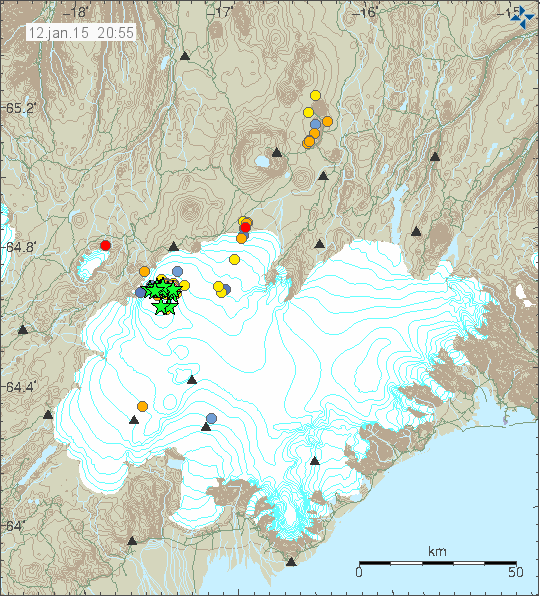
Latest earthquakes in Bárðarbunga volcano for the past 48 hours. Copyright of this image belongs to Icelandic Met Office.
Earthquake activity has been increasing in the past 24 hours. I’m not sure why that is happening, but several magnitude 4,0 and stronger earthquakes have been taking place since midnight. That also seems to be the general earthquake activity in Bárðarbunga volcano at the moment. Earthquake activity along the dyke is also increasing, I am not sure what that means at the moment.
Air quality
SO2 pollution is a big problem in Iceland due to the eruption. Yesterday the SO2 pollution in a valley called Jökuldal, with pollution values going up to 7800 μg/m³. This pollution goes where the wind is blowing at any given time. Still weathers are the worst since that allows for SO2 to build up in the atmosphere and in location that are low in the landscape.
Icelandic News
Einn fegursti gígur Íslands er að myndast í eldgosinu (Vísir.is, Icelandic, video)
Dimmt af mengun á Jökuldal (Rúv.is, Icelandic)
Article updated at 23:08 UTC.
Article updated at 23:42 UTC.
Article updated at 20:16 UTC on 13-January-2015.
Article updated at 20:19 UTC on 13-January-2015.
Thanks for the update, Jón.
I’ve noticed that the tremor has spiked at around the same time as the deep earthquakes that have occurred during the last couple of days. Would I be right to think that this means that magma is on the move, and if so, that this could account for some of the increased earthquake activity?
For those who want to see the video clip, it’s ca. 8 minutes into the news, here: http://www.visir.is/section/MEDIA99/&fileid=SRC2248B633-E802-4E03-A693-B9EFCBBEA280
Almost certainly an injection of deep source magma entering the system I suspect.
There is still GPS shift showing at hauc over the past three days.
Hauc is a bit of a distance from the eq activity, isn’t it? And there’s a lot of uncertainty about it, too. From my position of almost total ignorance, given that the big, deep eqs are under the N-E quadrant of the caldera, wouldn’t we expect GPS drift to be showing closer in to BB?
Hauc is a distance to us, but in geological terms not far at all. If it is moving, then so is a fault. Collectively there has been so much movement in the monitored area of the current event. This will have repercussions elsewhere, it’s just a question when?
The question of the moment IMHO is what is happening deep below bb. The GPS shift we all watch is measured on the surface, it does not account for multi planar movements that are wholly subterranean in any other manner than denoting positional data on the surface, which in itself may be reactive to other influences. We all know the hreppar plate moves in this way, but the forces it exerts also act in Newtonian manner on that which surrounds it.
There are so any ifs, buts, and maybes. The holuhraun has not closed off due to deposition of crystalline structure, which means the feed temp is very high. I wrongly thought this would have been more evident by now.
Irpsit has long held the view that holuhraun will ultimately become a shield volcano. This is now a distinct possibility, but if it is the there has to be some rethinking about its source, since a chamber depletion at bb is looking much less likely. I have never agreed that this was chamber fed.
I maintain that we will be looking at a such larger area in the future, and the valley between bb and tungsnafellsjokul will become an area of activity.
This is like Stefan Mueller said somewhere, a crossing of a transform zone and a rift zone with a turning microplate involved. So this is also at the moment a rather large and complicated setting with many factors playing a role. Also as this is a rifting event in Iceland, other parts of the rift will become / are being involved. The scientists have up to now measured movements over a distance of about 100 km from north to south and over Barðarbunga. http://www.vedur.is/skjalftar-og-eldgos/gps-maelingar/bardarbunga/
And this text by Magnús Tumi Guðmundsson etal. is showing very clearly the connections between rifting events in Iceland and volcanic activity in Vatnajökull region: http://geology.gsapubs.org/content/26/10/943
I agree with much of what you say, esp about the complexity of the system and the source of the magma that is erupting at Holuhraun.
It’s just that I’d have thought that the relative lack of movement at GPS stations nearer to where the magma seems to be being injected and the degree of uncertainty around Hauc would cast some doubt on just how significant in the overall scheme of things its movements over the last few days.
Also, given (1) the low overall displacement at Hauc since events began in August relative to other nearby displacements (see the second diagram shown on Inge’s Vedur link) and (2) the fact that current eq patterns are generally similar to those that we’ve been seeing since the onset of events, I’m not seeing a strong argument for putting a lot of weight on what’s currently going on at Hauc.
It certainly does look as though Tungnafellsjokull is livening up, and there’s a history of this over the last few years. I walked from Nyidalur to the south coast via Vonaskard and Langisjor 18 months ago. Had I know about the fissures, sink holes, etc. that had recently appeared near the hut, I’d have gone out to have a look at them.
Oops – just spotted that Jón’s first link is to the news item.
Dear Jón,
Last week you said that in a few days the lavafield would become larger than the largest lake in Iceland.
Do you have any news on that?
Kind regards,
Henk Weijerstrass
Holland
10 biggest lakes of Iceland (in german, but I think you can translate) https://www.extremeiceland.is/de/ueber-island/die-10-groessten-seen-islands
Lavafield is now > 84km2 ->https://twitter.com/uni_iceland
It has the size of Þingvallavatn lake. That lake is around ~84 km² in size.
Amazing video footage on that news magazine! A 400-500 m long lava lake! Never seen anything like that. It slowly feels like a very deep magma source has been tabbed looking at the high lava temperature, extrusion rates and duration of the eruption. From the volcanological point of view this will go on for quite a while and will provide an immense new look at this kind of eruption style, and some new studies and papers for the academic world.
It really is the land of ice and fire at the moment! Did I see a yellowish sulphur deposit around the crater rim in the video?
My opinion, too, Andrew!
Ian posted some pics in Jons previous article’s comments.
This is one of them:
https://fbcdn-sphotos-h-a.akamaihd.net/hphotos-ak-xap1/t31.0-8/1524225_886052198081479_5426148391783066432_o.jpg?efg=eyJpIjoidCJ9
The picture shows it quite nicely (I think).
Hi Gizmo,
the “Lower Saxony Gang” plans a meeting. 🙂 If you are interested: icevolc(at)gmx.de
Whater is rising very fast in Jökulsá á Fjöllum. I think a Jökulhlaup is happening… http://www.ijsland-enzo.nl/ijsland/actueel_waterstanden.asp?id=V102
WOW! Huge fall now! http://vmkerfi.vedur.is/vatn/vdv_gmap.php
See the discussion on the previous post at 20.00 onwards on the 11th January, especially Jon’s comment.
The 30 day plot for J a F at Grimsstadir implies that there is nothing particularly unusual about what is going on at present. And if it were a jokulhlaup, then there’d be other signs of a dramatic increase in activity at Bardarbunga, wouldn’t there?
http://vmkerfi.vedur.is/vatn/vdv_gmap.php
Thank’s! I didn’t see it!
What do you think why this happens?
http://en.wikipedia.org/wiki/Cryoseism
Hi Andrew,
my question was thought for Luis … we have answered at the same time :-).
Tuesday
13.01.2015 13:17:29 64.793 -17.819 3.7 km 3.1 99.0 14.0 km ENE of Nýidalur
EQ swarm at Tungnafellsjökull right about now. Also an increase in activity at the dike intrusion
http://mobile.nytimes.com/2015/01/06/science/predicting-what-a-volcano-may-or-may-not-do-is-as-tricky-as-it-is-crucial-as-iceland-well-knows.html?_r=1&referrer=
THANKS, JB,
Have long thought about those hydro-electric dams to the West.
I suppose it would be economically more than difficult to do . . . however . . .
What about the effectiveness of diking up the river some significant distance upstream from the dammed lakes . . . forcing the rivers involved through a series of dammed switchbacks . . . say 5-7 such switch-back ‘dams.’
Were the water would go first, say, around the West end of such a dam, then the next dam, it would go around the East end, then the West end, then the East end etc.
Such that, one would hope . . . a massive flood from a big eruption would be somewhat effectively slowed a significant amount.
Earthen dams of such construction would be far less expensive than concrete and probably for this purpose about as effective.
Certainly the expense would be huge . . . And given only probabilities, I have no idea how worth it such doings might be.
I just shudder at the thought of so many thousands of people being without electricity in the midst of other traumas of a big eruption.
THOSE difficulties would be FAR MORE expensive . . . after the fact.
I’ve also wondered . . . from this considerable distance as an observer . . . it appears to me that TO SOME DEGREE and in SOME ways, Icelandic folks can come together above average–compared to other regions of the Western world. That is, they can work for a common goal with more energy and cooperation than average. Is that true?
IF TRUE, it seems to me they would be wise to begin to INSURE durable food stockpiles to prevent the sort of starvation that occurred in earlier centuries, from a huge deadly eruption.
It just seems to me that a huge eruption in this era is all but certain. And who knows the results. Nevertheless, LOCAL & NATIONAL COMMUNITY BASED stockpiling of some basic food stuffs seems more than wise, to me.
Blaming officials and each other AFTER THE FACT, would NOT fill any mouths.
. . . Just my 2 cents. ($0.02USD)
BTW, I uninstalled the CHROME browser yesterday. It complicated too many things for me recently. However, I miss the Google translate. So, to all those hereon who translate key sentences into English–THANKS TONS.
May you all have an overcoming and satisfying week.
Tuesday
13.01.2015 15:05:29 64.611 -17.421 9.2 km 4.4 99.0 6.0 km ESE of Bárðarbunga
Tuesday
13.01.2015 15:00:43 64.611 -17.428 8.1 km 4.6 99.0 5.8 km SE of Bárðarbunga
nice quake swarm now…
Tuesday
13.01.2015 17:51:58 64.659 -17.406 9.9 km 4.6 99.0 6.1 km ENE of Bárðarbunga
Tuesday
13.01.2015 17:41:49 64.672 -17.402 8.9 km 4.2 99.0 6.9 km ENE of Bárðarbunga
Tuesday
13.01.2015 16:22:12 64.626 -17.578 10.0 km 4.2 99.0 2.9 km SW of Bárðarbunga
Washington Post article.
http://www.washingtonpost.com/news/morning-mix/wp/2015/01/12/iceland-lava-field-may-now-be-the-biggest-in-200-years/?utm_content=buffer757ca&utm_medium=social&utm_source=twitter.com&utm_campaign=buffer
NASA.
http://earthobservatory.nasa.gov/NaturalHazards/view.php?id=85031&src=twitter-nh
I think a M5.1-M5.5 is about to come, in the next 24 hours. The patterns seems to be the same as before.
But today it seems to give strenght to the hypothesis indicated a couple of days ago when someone (maybe it was Jon) said that a new influx of magma was coming under Bardarbunga. We just see increased activity in the rifting zone, and also near Tungnafellsjokull.
When such M5 occurs I will be feeling it, unless I am sleeping. Will keep aware this evening.
Tuesday
13.01.2015 20:25:04 64.672 -17.455 7.5 km 4.3 99.0 5.0 km NE of Bárðarbunga
” Iceland’s ongoing Holuhraun eruption has radiated the most heat for an event.”
http://earthobservatory.nasa.gov/blogs/earthmatters/2015/01/09/the-hottest-volcano-of-them-all/
As I said , very much a heat driven event.
Wednesday
14.01.2015 06:19:15 64.668 -17.459 8.9 km 4.3 99.0 4.5 km NE of Bárðarbunga
Wednesday
14.01.2015 12:32:15 64.498 -17.492 2.5 km 3.5 99.0 14.7 km NW of Grímsfjall
New article about Bárðarbunga volcano is up. 🙂