
The eruption in Holuhraun continued last weekend as it has been doing for the past two months. No change happened. Due to bad weather this weekend it was difficult to monitor what was happening in Holuhraun. The eruption continues at full force from what I can see on Míla web cameras, when I was viewing it earlier today I noted that lava strokes where going up 20 – 50 meters high up. The main crater has build up around 90 meter high wall around the main eruption, blocking all view to it. I don’t know how stable this wall it, so collapses might happen in it at times without warning.
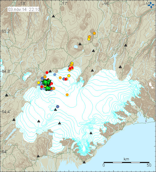
Earthquake activity for the past 48 hours in Bárðarbunga volcano. Copyright of this image belongs to Icelandic Met Office.
Largest earthquake during the weekend had the magnitude of 5,4. Other earthquakes where smaller, but there was a lot of earthquakes that had magnitude larger than 3,0. This high volume of strong earthquakes continues in Bárðarbunga volcano, so far more than 61 earthquake have been larger then magnitude 5,0, more then 228 earthquakes with magnitude 4 – 5 have happened since this started and more than 434 earthquakes have happened in Bárðarbunga volcano since August. The amount of magma that has erupted in Holuhrauni lava field is now 1,0 km³ (or more). The new lava now covers 70 square kilometre area according to last measurements that I know of. The eruption in Holuhraun is still fourteen times smaller than Laki eruption that happened 1783 – 1784. Far as I know there is currently nothing more to report.
Icelandic News
Stærsta gos síðan í Skaftáreldum (Rúv.is, Icelandic)
Donations: Please remember to support my work with donations or by shop with Amazon links that I have up here. If I don’t have a banner up from your area of the world please check this site that I have for other regions. I only support North America and Europe for Amazon store, since I get most of my traffic from those areas.
Article updated at 00:37 UTC on 04-November-2014.
Thx for the update Jon 🙂
Are there any new infrared or radar images of the extent of the lava flow . . . particularly at the interface with the river’s various streams?
@Jón, thank you for the update. 🙂
@Da Xin,
here are some radar pictures from Holuhraun from 29. October.
http://www.lhg.is/frettirogutgafa/frettir/nr/2899
Thanks much.
It looks like the lava flow is doing what I expected . . . squeezing the river’s various streams against the South-Eastern bank more and more. Is that the falls tourists love to visit in the lower right quadrant? Hmmmmm
The waterfall near the eruption sites, is not well known and in a so remote region that only few tourists have the chance to see it.
The really famous waterfalls in the same river (Jökulsá á Fjöllum) are to be found about 200 km to the north (the waterfalls Selfoss and esp. Dettifoss https://commons.wikimedia.org/wiki/File:Island1984_081.jpg ), far from the eruption site and downriver.
Dettifoss btw. is situated within a very impressive canyon, the Jökulsárgljúfur which is also part of a national park (the canyon, near Dettifoss: https://commons.wikimedia.org/wiki/File:Jokulsa_a_Fjollum_02.jpg ).
Da Xin, I found a link on the computer today that had a breakdown of the event up to yesterday. There seemed to be some recent photos of what you asked about. I am not on the computer at the moment, but tomorrow I will see if I can find it again and post it, if no one else has answered you.
Thanks for the updates Jon, we’ll informative as usual. Keep up the good work.
That would be WONDERFUL. THX THX BIG.
That’s an abiding interest of mine, for some reason. I guess I like to watch the dynamic of the flowing lava intersecting the flowing water . . . and the resulting consequences.
I hate the autocorrect on this phone. That should read well informative.
Yes, autocorrect can be very annoying, I know all about that.
BTW: I like the stories about your volcano-loving grandson. 🙂
Not a story, he has always had an interest in rocks from an early age. First it was just that they were to collect, then later he got a collection from a friend who had the monthly about rocks that came out in the UK. He has a collection of nearly 150 rocks of different types and is getting good at naming them. His biggest piece is. Limb of black lava from Vesuvius I got him last year. And when he says he wants to be a vulcanologist I believe him. He spends hours with me when he can looking at this eruption and asking questions. Sometimes I think he has an old head on young shoulders.
Auto correct again Lump of black lava.
I’m guessing he already has one but get him a geologist’s hammer. It was my prized possession as a child.
A UV lamp is a good thing to get a budding geologist as well.
I have collected rocks all my life since I was about 12. I am now 60 and still at it. I live in SW England
@Clive. Sorry, I really didn’t mean that I wouldn’t believe what you tell us. 🙁
I think this was a language problem…
It is very fine, that your gandson is so enthusiastic about volcanoes. 🙂
Gas pollution again in the south of Iceland now. Levels up to 1000ug/m3 at least. Haze thicker than during the day, visibility only 10km, smells dirty air, still not that bad for breathing for a while. But levels might get eventually pretty high this night…
@Clive . . .
any son who will spend hours with his dad doing anything . . .
is a GREAT testimony about both of them. CONGRATS.
You do realise you can switch off auto-correct on your phones?!
Does anybody have an idea about all of the unverified small earthquakes that show up at exactly 1.1km? Is this some sort of technical fault/feature or is that a particularly interesting depth?
(The Captcha seems to be in Klingon, hard to believe they came up with something harder to understand than my handwriting….)
1.1 km is indeed a default depth. Pay it no attention.
From IMO (not manually checked yet)
Tuesday 04.11.2014
05:32:26 64.610 -17.420 1.1 km mag 3.6 6.1 km ESE of Bárðarbunga
QQ could the activity currently taking place at BB start to awake other volcanoes / fault lines in it’s neighborhood and if so which ones could start to grumble into being awoken..
I seem to have lost the real time drum plots … They stopped updating yesterday at 11am. Can anyone help with a link please ?
http://brunnur.vedur.is/myndir/vala.png
Jón’s plot: http://www.jonfr.com/webicorders/hkbz.gif
Nice. Thanks for that.
You can write a mail to IMO … my be they didn’t know that the updates stopped -> http://en.vedur.is/about-imo/contact/
Any Comments On Increased Geothermal Heat In B. Volcano?
Thank you 🙂
I wonder how it is that the caldera drops and then comes back up.
it is quite flexible and I hope someone can explain me that.
Thanks in advance.
The column of rock more than 1km above ground level is held up by magma pressure. As a result of tectonic plate rifting the magma chamber has split to deeper levels allowing magma to be pushed down by the column of rock. The opposing force is hotter less dense magma rising and pushing up. Whichever force is stronger moves the plug up or down. Currently, on average the downward force is the stronger. There is probably tubulence in the hot/cold magma mixing perhaps event coriolis effects and material composition variations all changing the upward pressure, the downward pressure only reducing slowly with the reduction in height and melting away at the base.
sounds like there are no frictional forces? Several kilometers of rock and 700 m of ice moved up and down within minutes due to coriolis force based mixture effects. Wow!
Think of it as a pancake. Hopla, there it goes up. Pfffff, there it subsides like a pudding. Until you throw it up in the air to turn it upside down. It’s all that simple.
i guess it behaves more like a soufflé
http://www.monambelles.de/wp-content/uploads/2011/05/Feta-Souffl%C3%A9-620×465.jpg
Quite lots of volcanic gas across Iceland today.
Woke up in morning and air was dirty, heavy and smelling a bit like car exaust. The SO2.
Haze was thick greyish everywhere. No sun visible.
Then pollution started to soften a bit and started to snow. Now smells something different and even funnier. Fresh ozone/bleech-like smell. Really it looks like someone just ozoned the entire region.
Ahh and I can’t find the pH strips at home! I wanted to test this wet snow to see how it measured! Acidic snow with bleech smell, yeah afternoon after a smoky exaust SO2 morning!
Values up to 5000 ug/m3 in north coast. Up to 2000 ug/m3 in south coast. But probably higher levels where I live further inland.
I think it’s not going to be nice when all the accumulating acidic snow, laced with chroline, fluoride and other elements, melts suddently in early spring. Especially in areas near the volcano and where snows a lot, like northeast of Iceland.
I agree. This does not look good. Wonder if science has some ways to counteract the effect?
you can see it on the MILA BB cams too … and also here -> http://vefmyndavelar.mogt.is/ (last cams)
It is very simple and I’m not surprised that you dont know that the direction of movement will not be determined by “frictional forces”. There is no frictional force if there is no movement (f=ma where a is 0). If you meant material restance to sheer stress, then the rocks have falted and broken long ago. Given the huge forces involved the resistence to movement is comparitively small and decreasing.
For simplicity I would like to cite Wikipedia. I received my PhD in Physics quite a while ago, but a few things I still remember 😉
http://en.wikipedia.org/wiki/Friction
Static friction
Static friction is friction between two or more solid objects that are not moving relative to each other. For example, static friction can prevent an object from sliding down a sloped surface. The coefficient of static friction, typically denoted as μs, is usually higher than the coefficient of kinetic friction.
The static friction force must be overcome by an applied force before an object can move. The maximum possible friction force between two surfaces before sliding begins is the product of the coefficient of static friction and the normal force: F_{max} = \mu_s F_{n}\,. When there is no sliding occurring, the friction force can have any value from zero up to F_{max}\,. Any force smaller than F_{max}\, attempting to slide one surface over the other is opposed by a frictional force of equal magnitude and opposite direction. Any force larger than F_{max}\, overcomes the force of static friction and causes sliding to occur. The instant sliding occurs, static friction is no longer applicable—the friction between the two surfaces is then called kinetic friction.
An example of static friction is the force that prevents a car wheel from slipping as it rolls on the ground. Even though the wheel is in motion, the patch of the tire in contact with the ground is stationary relative to the ground, so it is static rather than kinetic friction.
The maximum value of static friction, when motion is impending, is sometimes referred to as limiting friction,[17] although this term is not used universally.[1] It is also known as traction.
For simplicity I would like to recommend Wikipedia. I received my PhD in Physics quite a while ago, but a few things I still remember 😉
http://en.wikipedia.org/wiki/Friction
The relevant part is under “Static friction”
“Static friction is friction between two or more solid objects that are not moving relative to each other. For example, static friction can prevent an object from sliding down a sloped surface. The coefficient of static friction, typically denoted as μs, is usually higher than the coefficient of kinetic friction.”
Its not static its moving. Any resistance caused by intermolecular van der Waals forces or even material physical micro and macro irregularities has already been overcome. You should have noticed this. This isn’t nuclear or astrophysics, just the basics, mechanics, hydraulics, thermodynamics and a splash of chemistry. Now I’ve had enough of our Amygdalas and I’m going to put mine in a box.
There is no frictional force if there is no movement (f=ma where a is 0)
Once again I took a photo of Reykjanes peninsula from my balcony in Seltjarnarnes – far left is Mt Keilir. Taken through the SO2 mist and some crepuscular rays. Very eerie light:
http://i.imgur.com/4omuwQW.jpg
Nice photo.
Irpsit, weather charts for Friday 14th Nov (although 10 days out) are showing High pressure system close to Iceland. If the vent is still producing an SO2 plume, there will be little air circulation to clear the poisonous gases away.
It’s something to watch closely. Air and gas from the vent will rise but it’s also going to be similar to standing behind running vehicles on a still cold day. Suffocating.
If weather system occurs then risk to health increase even more than current high levels.Stay safe everyone.
For the first time in my life, I´m wishing it was windy. Normally the Icelandic winds are persistent and annoying, but who could have foreseen this situation would occur. So let´s hope for a bunch of stormy weather patterns.
Kolla, that’s my worries for all of you, the long range models, anomalies are showing little or no winds around Iceland and Greenland for Winter. Hope there wrong.
Long range weather models are not very reliable. In Iceland, you have a lot of storms during every winter, often more than one per week. So let’s hope this will develop according to this pattern – or better still, the eruption will just stop.
http://www.volcanodiscovery.com/bardarbunga/seismic-crisis-2014/updates.html
Update Mon 27 Oct 15:49
According to the latest information from IMO, geothermal heat is increasing in Bardarbunga volcano, which could indicate that an eruption at this location is becoming more likely.
any comments on this?
That’s from 27 Oct, and is not precise enough to know more than what they said.
As a guess, it could be the location of a minor eruption in the caldera under the ice. That might have melted the ice at that spot into a pocket of water. A cauldron in the top of the ice right over the spot should be visible.
thanks. I think “not precise” is the bottom line in that posting.
How about this diagram?Ignore the Yellowstone aspect and just note the general mechanism.
http://pubs.usgs.gov/fs/fs100-03/images/caldera.jpg
More money for the organziations that have to handle the eruption:
” It is stated in a press release that the government has agreed to provide 329 million (ISK!) to key organizations for costs in August and September.
It was agreed to set aside 358 million to the end if the state of the volcano remains unchanged. The total amount of 687 million.
…
IMO gets 59 million, partly due to a significant increase in employment and the presence of workers in both monitoring measure but also the presence of a volcanic land.”
(google translation, IngeB will do it better 🙂 )
http://www.ruv.is/frett/allt-ad-687-milljonir-vegna-eldsumbrota
The last should read:
And so IMO gets 59 mill. ISK, a.o. because of the real increase in work and the presence of workers with both monitoring measurements and being at the eruption sites. –
(Þá fær Veðurstofa Íslands 59 milljónir króna, meðal annars vegna verulega aukinnar vinnu og viðveru starfsmanna bæði við vöktun mæla en einnig viðveru á gosslóðum.)
BTW: This is a bit strangely worded, also in Icelandic.
Two big double quakes!
Three big quakes
Tuesday
04.11.2014 17:14:52 64.685 -17.505 7.3 km 4.1 99.0 5.1 km NNE of Bárðarbunga
Another big one!
Melodramatic computer at
http://brunnur.vedur.is/myndir/vala.png
“scream: Fatal IO error: client killed”
there goes our only working drum roll
Last time, Mr. Client was brought back to life after some ours. 🙂 He will make it!
We still have Jón’s drumplot! It’s the last we have now….
http://www.jonfr.com/webicorders/hkbz.gif
Ok and it´s lively too. More EQs for the collection.
And kudos to Jon! It illustrates the value of independent monitoring.
Tuesday
04.11.2014 20:50:57 64.676 -17.459 8.9 km 4.3 99.0 5.2 km NE of Bárðarbunga
Tuesday
04.11.2014 20:45:27 64.668 -17.514 4.9 km 4.8 99.0 3.1 km NNE of Bárðarbunga
The number of smaller EQs seems to have gone up. Does that mean magma is on the move?
This might be new magma coming up from depth. The flow does not have to be constant if there is blockage at depth that might have gotten loose or changed. The path the magma is taking up to the surface might also have changed.
Would make sense. The increased magma pressure is also registered by the slightly lower rate of subsidence (now about 1 m for 3 days of the chart).
How do you monitor the frequency, or relative frequency/percentage
of smaller EQs vs. larger ones? I am interested in this. What time frame?
e.g., percentage of 2.0’s to 3.0’s out of total number of 3.0+’s ? weekly?
and for monitoring large ones … percentage of 4.0+ out of total 2.0+?
does this sound reasonable? or what do you suggest. (to monitor more
objectively, I am interested in this type of analysis/approach)
what would be good source of EQ data in this format as much as possible?
thanks
I had typo. meant to say 2.0’s to 3.0’s out of total number of 2.0+’s?
Either that or the wind has died down, or both. Frustrating.
The wind has died down, but activity has also been increasing in the last few hours. You can find IMO wind map here.
http://en.vedur.is/weather/forecasts/elements/#type=wind
Magma can reach the surface from some depth in a matter of hours,this event has been ongoing for 2 months with over 60 magnitude 5+ earthquakes.If magma was moving to the surface with this activity it would have done so by now ,this is all related to changes in the magma chamber of the caldera,other calderas around the world have earthquake swarms due changes in the magma at depth.
It was actually easier for the magma to find a path through 40 km of rock than migrate in any significant amount via 10km of rock to the surface of the caldera.Now why is that?It cannot be the rock of the “plug”,it could be a layer of old magma between the mantle sourced basalt and the surface,this takes the infusion of heat from the basalt and transfers this energy via the ring fault as quakes.
Since rock is a great insulator that retains heat for a long time, heat cannot easily move through it. Whereas, as you said, very hot highly fluid magma can widen and flow through any cracks with ease, taking the heat with it.
Then the question becomes where are the cracks in the brittle basaltic rock? Most would be under the rift zones, neatly aligned NE-SW.
I don’t know how the upper part of Bardarbunga has resisted so well between the tug of the Eurasian and the North American plates. But it, and the glacier, seems to be like a lid on a boiling pot.
What do you think?
Heat cannot move through rock?Magma is molten rock?The earth’s surface warms in the sun?People cook using hot rocks?
Yesterday, I sent a message via the Institute of Earth Sciences website, to ask how the profiles of the caldera were produced. (see http://jardvis.hi.is/maelingar_siginu_i_bardarbungu_med_flugvel_isavia_tf_fms_24_oktober_2014 )
Today I received the following reply:-
[Subject: Radar used for profiling ice surface at Bardarbunga]
“Hello Peter
“The method used for radar profiling at Bárðarbunga is described in the attached paper. It is a system that combines a ground clearance radar and kinematic GPS (actually, now an Omnistar submeter GPS is used). It mappes the glacer surface.
“best wishes, Magnus
“—————————————————————
“Magnus T. Gudmundsson,
“Professor of Geophysics
“Institute of Earth Sciences, University of Iceland
“Sturlugata 7, 101 Reykjavik
The attached paper was:
Geothermal activity in the subglacial Katla caldera, Iceland, 1999–2005, studied with radar altimetry
Authors: Guđmundsson, Magnús T.; Höganadóttir, Pórdís; Kristinsson, Arnór Bergur; Guđbjörnsson, Snaebjörn
Source: Annals of Glaciology, Volume 45, Number 1, October 2007, pp. 66-72(7)
Publisher: International Glaciological Society
This link, if it works, gets to the Abstract
http://www.ingentaconnect.com/content/igsoc/agl/2007/00000045/00000001/art00009;jsessionid=afhrlgntbb7o0.alexandra
I thought you guys might be interested.
Please note that profiles across the caldera are flown twice a year.
That twice a year profiling flight (mentioned in the abstract of the paper) was for Katla caldera; I don’t know if they still continue. The same method is used at Bardarbunga, with at least 6 flights since 2014-09-05.
@ Peter W
Well ok, if you say so, Prof. Gudmundsson doesn’t mention the frequency, nor if the glights were succesful.
And it still only profiles the ice surface. I don’t know if any GPR radar is used on these flights. If possible, to profile the ground (caldera) subsidence, you have to calibrate your flight height in combination with GPS and/or laser.
In Canada GPR attached to a heli is used to measure the ice and snow thickness.
http://www2.mar.dfo-mpo.gc.ca/science/ocean/seaice/Publications/lalumiere12.pdf
This paper shows use of Ground Penetrating Radar on Katla: http://www.jokulljournal.is/50-59/J55p155-162.pdf
Just some interesting images. I think this is a sat. image of the caldera (30 Oct), could someone confirm it? I can see large cauldrons and the monitoring equipment in the lower left.
https://astereds.cr.usgs.gov/show_data_browse_fullsize.php?id=14385&mode=2&desc=Bardarbunga;%20Iceland&type=VNIR&date=10/30/2014%2012:55:31
I think this one is the eruption site, if I’m not correct please let me know.
https://astereds.cr.usgs.gov/show_data_browse_fullsize.php?id=14384&mode=2&desc=Bardarbunga;%20Iceland&type=VNIR&date=10/30/2014%2012:55:31
The last one is the eruption site, yes. It is easily to be identified, because it shows the Askja caldera lake Öskjuvatn to the north, and the big snd long reservoir Hálslón to the east.
Cauldera drop graph on 3dBulge shows 3 and 1/2 metre drop over the last couple of hours. Both traces. Never seen anything like it before. Can someone please tell me if, once again, I am jumping to conclusions?
This is the web address. http://baering.github.io/
Does anyone have the link to the similar 3D image but which was more vertical? For some reason, that one is my preference. It’s easier for me to visualize the topography WITH that 3D version. It’s very similar–just more vertical
It doesn’t look that way on the IMO site. The 3 day is showing an uptick, whereas the running graph does still show the steep drop you describe. I suspect it’s just doing it’s up and down thing, á la Kansas.
I’ve posted this IMO reply to questions on drop data before, hope this helps –
The gray fluctuating data in the background is the processed real time 1Hz
data which is subject to number of uncertainties.
The answer is probably both. Part of the fluctuations are noise part of them
are real. I have not analyzed the data in way that enables me to distinguish
this though.
There are probably some fluctuations on the surface of the glacier associated
with earthquakes, the fact that the Ice is flowing towards the center, waves
propagating through the glacier and etc. These signals can have pretty wide
frequency spectrum depending on the source of the waves and it’s path.
However only part of the fluctuations you see on the graph are real movements.
There can be orbital errors, multipath effects, satellite geometry and possibly
some atmospheric variations and more.
The blue line is a 180 min median, and for all practical purposes this gives
the steady state movements and the offsets that we want to follow.
The red line is a 30 min median and might hint on real variations on the ice
surface, although they would need proper analyses for a meaningful
interpretation.
The grey line in the background is, as you say more or less noise, at least
until the data is properly analyzed, although I suspect that within it lie
interesting signals.
If you want imagery http://vorklift.com/volcano/gps_bardarbunga/
For 3 and 4D eq data over eruption period visit dfm’s pages here –
https://www.youtube.com/user/dfmorvan/videos
Todays interesting development (which is uncorrected) is here on the strain gauges –
http://hraun.vedur.is/ja/strain/1sec/index.html
Wednesday
05.11.2014 03:23:59 64.680 -17.430 1.1 km 4.3 50.5 6.4 km NE of Bárðarbunga
Wow…just watching Mila 2 before going to work and the screen was shaking for about a minute. Have I just witnessed a big quake at 6.25am?
wind
Yup, Heinz 57
Sadly yes, just wind. Mila 2 has quite a high level of zoom so it doesn’t take much to get the image to shake. And up on that mountain, there’s a lot of strong gusty wind even when it’s relatively calm lower down.
Porsche928. Normally airborne radioechosounding systems penetrate the ice, and image not only the ice surface but the ice-bedrock interface and any internal radar reflectors such as the water-ice interface created by the presence of bodies of meltwater such as subglacial lakes. This has been a standard technique in glaciology for more than 40 years, although GPS navigation will have improved its accuracy, and is how lakes under Antarctic Ice Sheet like Lake Vostok and Lake Ellsworth were discovered and mapped:
https://www.google.com/search?site=imghp&tbm=isch&source=hp&biw=1280&bih=752&q=radar+Lake+Ellsworth&oq=radar+Lake+Ellsworth&gs_l=img.12…19525.32050.0.34060.20.19.0.1.1.0.377.3477.0j6j7j2.15.0….0…1c.1.58.img..9.11.2221.zbsytpC27_E#facrc=_&imgrc=NApxs4Eo7VwozM%253A%3BPWGhbGumirh8EM%3Bhttp%253A%252F%252Fwww.scitizen.com%252FcacheDirectory%252FHTMLcontributions%252Fimg%252FSnapshot%2525202008-01-21%25252011-57-17.jpg%3Bhttp%253A%252F%252Fscitizen.com%252Fclimate-change%252Fthe-exploration-of-subglacial-lake-ellsworth-in-west-antarctica_a-13-1408.html%3B475%3B276
I should be very surprised if the instrumentation used in recent overflights of Bardarbunga was unable to detect the subsidence of the caldera floor or any substantial pockets of subglacial meltwater.
Yes, as far as mapping is concerned as referred to earlier on. For mapping a difference in elevation of the bedrock you have to have at least two fligh-overs with calibrated flight height. I don’t know if that is even worth the trouble.
Fire twister in Holuhraun lava field.
https://www.facebook.com/video.php?v=981236845224113
Like a Firework! Thanks for the link 🙂
Big quake will be updated! Wednesday
05.11.2014 14:01:26 64.620 -17.440 1.1 km 4.1 50.5 4.7 km ESE of Bárðarbunga
Update
Wednesday
05.11.2014 14:01:26 64.620 -17.387 8.7 km 4.8 99.0 7.1 km ESE of Bárðarbunga
eruption started at the Glacier ?????? or just strange clouds ?
Which cam are you looking at?
nr 1 at mila, but its probably just the “light” effect, but it just looks so alike a ash cloud ! and in the area of BB or DYN. above and to the right from the ongoing eruption
Clouds.
Rather clear view on mila cam 2.
yes probably, but it is out of sight for cam2 since it is way above it ! Cam2 is so focused to the eruption that it cuts out the top of the glacier.
OK, Maybe it’s just me, but I definitely saw some lava shooting up in front of the main rift on Mila cam 2. Took a screen shot, but am clueless on embedding. (16:20 BST)
You see the lava splashing over the edge of the crater and it’s also the point where the lavaflow begins.
yes, I can see it too – will better be able to make out what it is when it is darker.
If an eruption had started at/under the glacier and there was enough visibility to be seen from the cams, you would not be questioning whether or not it had started. It will be obvious. If you’re not sure, then that means no.
to the left of (and above) the ongoing eruption course, sorry for that.
I think there are steamclouds from the “lava-river-meeting” that goe up in the air. But you can’t see the glacier because of deep hanging clouds.
Picture from another webcam:
http://mynd1.mogt.is/mobile1/images/right/m141105162019309.jpg
Yes, the steam clouds from lava/river-contact appear white in front of the black lava, but when they sometimes get higher above the lava, they appear grey in front of the snow and can be mistaken as plumes from a non-existing “new eruption”. Actually, however, there is not much steam visible.
well i was certainly not talking about those, i was talking about the dark grey very large clouds in the upper right corner of the cam1 area, it was much larger then any spits from the lava/river confrontaition, but it must have been differences in lightning and wether, but it was right above the glacier and very large, at one time very mushroom like so it became very interesting, you can still see it sometimes in the far right corner but the visabilty to the galcier is vanishing (in the top of the screen) of cam 1. The lava meets the river in the bottom corner to the left, so it can not be mistaken by that, and is in a tiny scale compaired to what i was talking about.
Jonni, i think i have seen this cloud also, but that was also only a cloud…
it’s very tricky to see something at these cams…perhaps if it was fine weather with blue sky…but not under these conditions…
I also have seen the type of ‘eruption’ cloud Jonni has been describing. Large and black above BB and then makes and ‘anvil’ shape as it reaches higher up in the atmosphere. It is frightening to see and I wait for reports of an eruption….
But I found it was weather clouds which we can see many kms away on the Cam 1 and there are some tonight (on weather radar) to the west of Iceland. I am sure it is those now. These clouds are not the type we see with the steam or eruption plume (although those are quite scary enough I think)
Yes, that are steam clouds in front … here are more pics from that cam and time
http://mynd1.mogt.is/mobile1/images/right/m141105145018103.jpg
http://mynd1.mogt.is/mobile1/images/right/m141105150018323.jpg
http://mynd1.mogt.is/mobile1/images/right/m141105151019266.jpg
http://mynd1.mogt.is/mobile1/images/right/m141105152019142.jpg
http://mynd1.mogt.is/mobile1/images/right/m141105153018351.jpg
http://mynd1.mogt.is/mobile1/images/right/m141105154018337.jpg
http://mynd1.mogt.is/mobile1/images/right/m141105155019365.jpg
These is more noise on the infra sound channel ICE3. Does anybody know what that means? Wind or some other activity?
http://brunnur.vedur.is/myndir/vala.png
Screen plots are on again! http://brunnur.vedur.is/myndir/vala.png
Jon
in terms of: so far more than 61 earthquake have been larger then magnitude 5,0, more then 228 earthquakes with magnitude 4 – 5 have happened since this started and more than 434 earthquakes have happened in Bárðarbunga volcano since August.
what defines “earthquakes?” > what magnitude? in the count of 434. thanks.
I think the 434 are between 3.0 and 3.9.
See this chart:
http://en.vedur.is/media/jar/event_numbers_31102014_1900.pdf
Thanks. What is best source of weekly summary data for same category counts?
Perhaps you can use these list. But you have to count yourself 🙂
Weekly List:
http://hraun.vedur.is/ja/viku/2014/vika_45/listi
48 hours List:
http://hraun.vedur.is/ja/englishweb/eqlist.html
Is there another eruption left to the main one ?
Watching webcam 2 .
There seems to be a lot more steam rising aswell.
I am sure I have seen flames in the midst of all the black smoke/steam .
Could this be smaller eruptions along the line of lava?
I think it’s very unlikely that one could see “flames”: the camera is heavily zoomed in from a distance of at least 20kms from the eruption site. To get a sense of the scale, the crater rim is a good 50m above the lava flow.
Unless its my eyes I am sure you can see patches of orange sometimes at the bottom of the line of what looks like black smoke.
Can’t get anything on the cameras now, but are you sure it isn’t the lava flow?