
This is a short update on what is going on in Reykjanes peninsula. This article is written at 16:29 UTC.
Volcanoes in this article
Fagradalsfjall
Reykjanes
Krýsuvík
- Fagradalsfjall volcano has not erupted since Pleistocene. When last eruption took place is not listed or not known. This the first magma movement in Fagradalsfjall volcano in 11700 years.
- Eruption risk is now in Reykjanes volcano*.
- *This might also be a different volcano known as Svartsengi (no Global Volcanism Profile). There is no agreements between maps on this detail for now. Reykjanes volcano might only extend into Reykjanestá and then is mostly under ocean and might not extend into Reykjanes peninsula as sometimes is shown on maps.
- Krýsuvík volcano has quieted down a little in the last 24 hours. Eruption risk is lower for now in that volcano.
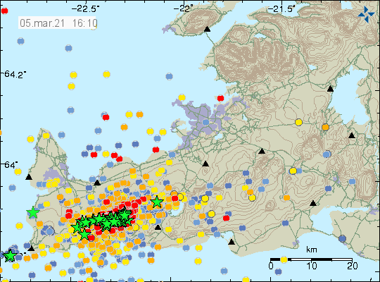
- Largest number of earthquakes detected in one day was over 3000 earthquakes.
- In the last 24 hours 12 earthquakes with magnitude above Mw3,0 have happened. Most of them are felt in nearby populated areas.
- No harmonic tremor has been detected since it ended during the night on 4-March-2021.
- During the last 48 hours over 3300 earthquakes have been recorded by Icelandic Met Office.
- New! Magma is now estimated to be at 5 to 6 km depth but might be as shallow as 2 km depth.
Maps of possible eruption areas has been made by Earth science department of University of Iceland and can be found here. University of Iceland Earth science department also made a lava flow prediction can that map can be found here. Both maps are updated daily on Facebook.
Web cameras
Beint vefstreymi af skjálftasvæðinu – Vogastapi (Rúv.is)
Keilir í beinni (mbl.is)
Óróasvæðið í beinni útsendingu (Vísir.is)
Live from Iceland
Keilir og skjálftasvæðið (YouTube)
Added at 21:12 UTC
Road camera 1
Road camera 2 (night vision/infrared)
Cameras and links might go offline without warning.
Donations
It is possible to support my work with donations. It helps me in current financial situation that has remained rather bad. You should only donate if you can. Other ways to support my website is to let people know about it if they are interested in earthquakes, volcanoes and geology in Iceland. Thanks for the support. 🙂
Article updated at 16:53 UTC.
Article updated at 21:13 UTC.
It is unfortunate that the Facebook pages you have mentioned are not public pages. If you are not a Facebook member you cannot see them.
Because of copyright of University of Iceland I can’t post them here since I don’t have permission to do so. That is why I can only link to them where University of Iceland posts those maps.
Some news in Iceland have permit to use the map images and I can try in the future to link to those also along with the Facebook links. I can’t always do this because sometimes the news doesn’t write a news article about the maps.
This news here is in Icelandic and has the lava field map if an eruption happens with local names of affected areas.
https://www.mbl.is/frettir/innlent/2021/03/05/eldgos_yrdi_liklegast_vid_fagradalsfjall/
All are fascinating every day something else happens
It is rather surprising (unless something has happened to veður updating) that everything has been beautifully quiet since 20:17 this evening.
It seems the site was frozen or just not updating for a time, but it now has and there was activity in the couple of hours after 20:17.
I’ll be busy most of the Saturday (6-March-2021) so I won’t be able to post update until after 18:00 or at the latest around 22:00 Iceland Time.
Still keeping a weather-eye on Katla (except the geologic/volcanic “eye” version..).
Tremor seemed to be back between 22 and 23 UTC , 6th March.