
This article is going to be updated as activity continues in Katla volcano today on 29-July-2017. If an eruption starts (big one) a new article is going to be written for that event.
Overview of the activity during the night and today
It seems that during the night a minor eruption took place (this is just my view). This based on harmonic tremor pulse that appeared in Katla volcano after midnight, the source of the activity seems to be north-west part of the caldera. Possibly where a magnitude 3,0 earthquake had taken place at 00:48 UTC. Harmonic tremor remains unstable and above background levels, at the moment however it seems that current harmonic tremor when this is written is due to glacier flood pushing it self from under the glacier. The water that is moving under the glacier is few hours away from (at best) from appearing in glacier rivers that come from Katla volcano.
The earthquake activity in Katla volcano during the last 48 hours. Copyright of this image belongs to Icelandic Met Office.

Harmonic tremor in Austmannsbunga in Katla volcano at 12:09 UTC. It clearly shows the minor eruption and ongoing harmonic tremor pulse. Copyright of this image belongs to Icelandic Met Office.
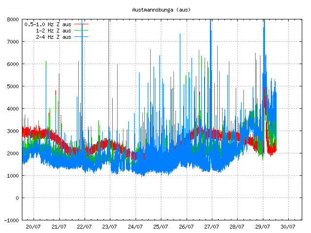
Harmonic tremor in Austmannsbunga in Katla volcano at 13:04 UTC. This image shows ongoing activity in the tremor. This is mostly high frequency tremor and that is interesting. What that is not known. Copyright of this image belongs to Icelandic Met Office.
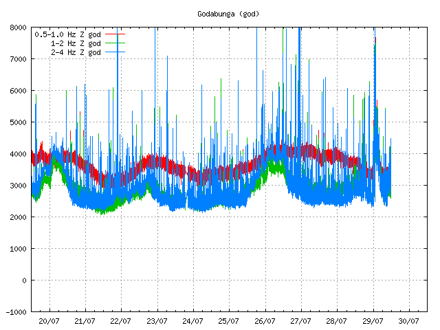
Harmonic tremor in Goðabunga at 12:09 UTC. It clearly shows the night minor eruption and ongoing harmonic tremor. The harmonic tremor is however a lot less visible now on Goðabunga. Copyright of this image belongs to Icelandic Met Office.
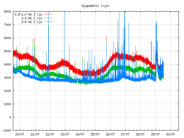
Harmonic tremor as it appears on Rjúpnafell (SIL station). This station is at more distance from the source of the harmonic tremor pulse and shows a weaker signal as a result. The night minor eruption is also clear on this SIL station but current harmonic tremor is less visible, it does appear but at much lower level. Copyright of this image belongs to Icelandic Met Office.
Katla volcano has been moved to yellow alert. It is now possible to watch the glacier flood live from here (Rúv.is). Currently the glacier flood is getting smaller, but that might only be a temporarily thing if more water is on its way from Mýrdalsjökull glacier. There has also been a drop in conductivity for now in Múlavísk glacier river.
Announcement in English on Rúv
People advised to stay away from Múlakvísl (Rúv.is)
This article is going to be updated as needed today.
Are those dark spots cauldrons Jon?
http://www.ruv.is/frett/rennsli-enn-ad-aukast-i-mulakvisl
No. This are old volcano ash deposits that have become exposed as the fresh snow melts away. Most glaciers in Iceland have old volcano ash deposits on them.
I’ll copy-paste the relevant last part of my comment from earlier article, since here is where the discussion is happening currently:
These sudden shiftings towards south-west in the AUST GPS stations, are they anything to take into consideration? Or is the data yet to be corrected?
http://brunnur.vedur.is/gps/eldfjoll/katla/AUST-plate-90d.png
http://brunnur.vedur.is/gps/eldfjoll/katla/AUST-plate-year.png
And thanks to Jón for your patience, continuous updates and helpful/informative comments.
This change in November-2016 is interesting. It clearly shows that magma pushed into the volcano close to Austmannsbunga area.
Ah! And what about the 2 most recent readings? Unless this is data that needs some some sort of correction, there was a displacement of 3-4 cm to the south and 2 cm west in the last two days.
Comment contributor “sf” really had luck with timing his/her trip to Iceland. Volcanic drama and summer weather! How are you doing over there, mate?
Absolutely! He or she catched a real good time to move there 🙂
We are loving it. Currently working our way round the ring road anti clockwise. About half way round now.
With all that pressure just a subglacial explosion?
I’m not convinced that this activity will necessarily lead to an eruption anytime soon. There is earthquake activity (just like last year) and some glacial melt (like we had before). But that’s part of the long, long process leading to an eruption. For sure, Katla could blow today, but it could also take a few years. We just have to see what she has in store for us.
I’m not convinced that the current activity will necessarily mean that an eruption is imminent. Sure, there is earthquake activity (like last year) and there is some glacial melt (like before). I consider it part of the long, long process that will eventually lead to an eruption. That could be today, but it could also take a few more years. We will have to wait in see what Katla has in store for us.
And now the million dollar question is this the calm before the storm or is she going to tease us for a while yet?
Whilst Katla’s behaviour is extremely interesting, for those who would like to see lava flowing, Piton de la Fournaise on the Island of Reunion has been in eruption for 15 days now. You can see it here.
http://www.ipgp.fr/fr/ovpf/actualites-ovpf
Activity in Katla volcano seems to have gone back to background levels. How long that is going to hold I don’t know.
Jon Iceland seems to have gone very quite this evening
The weather is no good at the moment in parts of Iceland and that reduces the chance of detecting small earthquakes properly. This sudden quiet sometimes happens in Iceland. I don’t know why that is.
Never thought sure even the camera at Katla was shocking with the wind. Thanks Jon
It rains here in Kerlingarfjöll heavily since 16:30 hrs this afternoon.
Temperature outside the tent has dropped to 4,8 degrees C.
So I’m also experiencing this country of fire and rain…
In case this hasn’t already been posted, Katla is on FB:
https://m.facebook.com/KatlaVolcano/
There is now some type of 3G or 4G noise device interfering with my geophone at Heklubyggð (the summerhouse is being rented out by its owner). The odd behaviour my geophone is seeing is radio noise on top of strong wind in the area of Heklubyggð.
The low in water level at Múlakvísl, Léreftshöfuð was reached at 16.00 and we see a low at Múlakvísl, Mýrdalssandur approaching .. maybe around 22:00-23:00 ? So, that means that the increase we could see at Múlakvísl, Léreftshöfuð from 16:00-20:00 will probably occur at 22:00-02:00 (meaning 02:00 UTC of tomorrow)? so, it might be interesting to see conductivity reading at Mýrdalssandur after 23:00 UTC to see if the water level increase is due to surface meltwater or any sub-glacial melting, maybe?
The yesterday (29-July-2017) glacier flood is over it seems. That does not rule a new glacier flood from Mýrdalsjökull glacier happening right after this one.
If the water starts to increase again, it is a new glacier flood.
Bárðarbunga volcano just had a series of earthquakes. This looks like the earthquake activity that has become the normal activity after the 2014 – 2015 eruption. I will write about it when I awake up. It also takes Icelandic Met Office a little time to analyse and get correct magnitudes of this earthquakes that just happened.
It looks like the ground around Mýrdalsjökull has moved toward Katla since the start of the tremor. Austmannsbunga has moved 40mm south west and Solheimaheidi has moved 10mm northeast. The ground doesnt appear to have lifted though.
http://brunnur.vedur.is/gps/katla.html
Could it be that Katla is releasing just enough pressure with those small eruptions to go back to rest for another year or so?
The tremor plot shows some rising again… http://hraun.vedur.is/ja/oroi/aus.gif
Seems to be inside the weather noise floor on this SIL station.
Even the red spikes? Thank’s!
The red line is not phased by weather. Ocean wave can influence it. The red spikes you are seeing appears to be some type of ultra-low period earthquakes. They are so small locating them is not possible and I suspect this events are being ignored by Icelandic Met Office.
What they mean I don’t have a clear idea yet. I suspect this might mean problem but it is difficult to know for sure.
I allways thought that the red low freq spikes was related with magma pulses or movement and the blue biger freq linked to weather or big whater movements like the glacier floods. Thank’s!
If that line moves as it did yesterday it is moving because magma is on the move.
Even that being the case, the background noise effect on it comes from the ocean tremor (when the wave hits the land, it makes it vibrate a little). That only appears on the lowest frequency on stations closest to the coast line. That type of noise is quite strong in south-Iceland coast line due to the deep Atlantic ocean wave hitting the south coast of Iceland.
I get the feeling that current quiet period is just a quiet period before the real eruption starts. Sometimes volcanoes do this, it is not know why it happen. It just does happen.
Articles about the quiet before an eruption.
https://carnegiescience.edu/news/volcanoes-get-quiet-they-erupt
I don’t know if this applies to volcanoes like Katla, might well be. That study however focused on volcanoes that erupt Intermediate (andesitic) and Felsic (rhyolitic) types of magma.
Magma types, https://en.wikipedia.org/wiki/Magma & http://www.tulane.edu/~sanelson/Natural_Disasters/volcan&magma.htm
(Source: Wikipedia)
Increased gas pressure will make water levels rise and suddenly drop right before an eruption, and thermal focusing (increased local heat flow) can reduce or dry out aquifers. Maybe this could be the cyclic nature of water levels observed at Múlakvísl, Léreftshöfuð; V414 ? (over a span of 1 week?)
Also, AUST GPS reading indicates a lateral shift in reference to both EU and NA plates. Maybe the magma is flowing into the caldera and causing a radial/outward movement where it’s weakest?
That is actual movement of the Austmannsbunga. The reference frame is used to count for plate movements that are always happening. They correct that movement against detected movement to get correct inflation numbers (I think, I’m no expert on GPS calculations).
There might be ice on the GPS antenna after the storm that’s been going on for few days now.
I have updated the eruption history article about eruptions in Iceland for the last ~1200 years.
http://icelandgeology.net/?p=765
Jon from so much activitie to so much silence not even a minor tremor in Katla!
Please note that if your comment vanishes and is not “held for moderation” it means it got eaten by the spam filter. It can take me few hours or a day to get comments out of there since I don’t check for it regularly if I’m not notified about it.
I will recover all comments from the spam filter box if they are not real spam (I don’t get a lot of spam at the moment).
The earthquake at Snæfellsnes is real. It just isn’t at Snæfellsnes. I’m not sure where this earthquake signal might be coming from. I also recorded it Heklubyggð geophone station, but not in Denmark (that rules out large earthquake far outside Iceland).
From the IMO map now it appears to be around Ljosufjoll.