
This information is going to go outdated quickly.
This is the current information about the eruption in Bárðarbunga volcano.
Please note: Since I cannot go to the area that is erupting my self (it is closed and I also live in Denmark at the moment). I have to relay on what is being told in the news and released by Icelandic Met Office along with other data. This means that I spend most of the day collecting data and working out what is going on (my view in most cases). This means that in most cases I write post late in the day when daily observation is done.
Current status of the eruption in Bárðarbunga volcano
- New fissure did open around 2 – 3 km south of the eruption fissure that started erupting 31-August-2014.
- Comments on this website did notice the eruption around 04:00 UTC on 05-September-2014. At the same time there was an minor increase in harmonic tremor on SIL stations close to the eruption.
- The new eruption fissure is around 1 – 2 km long. It might get longer as time passes.
- The new eruption was first reported by the press around 06:00 – 08:00 on Rúv.
- New cauldron has formed some 6 km in Dyngjujökull glacier. The glacier in the that area is 300 to 350 meters thick. Last report was that this cauldron was getting deeper during the day.
- Higher conductivity has been reported in Jökulsá á fjöllum glacier river. That is currently continuing on that last check I did on Icelandic Met Office website.
- Smell of rotten eggs is now coming from Jökulsá á fjöllum. Normally there is no such smell of that glacier river.
- Inflation in the dyke continues, not on the same speed as before, but it is ongoing.
- The rift valley appears to continue expand were he is visible.
- The air around the eruption site is toxic due to release of SO2, CO, CO2, fluorine gases and other dangerous gases.
- The water vapour cloud goes up to 4,5 km according to latest measurements.
- The SO2 goes the way of the wind direction at any given time.
- The lava field has just 1 km to Jökulsá á fjöllum glacier river. Once the lava enters the river it might start to build a dam and the lava is going to explode and steam a lot in the process.
- Largest earthquake since midnight was magnitude 5,3 that took place at 01:19 UTC. It took place in Bárðarbunga volcano caldera rim. As other large earthquakes since this events started.
- Largest earthquake in the dyke area took place at 14:31 UTC and had the magnitude of 3,2. It was under the glacier were most earthquake activity is now taking place.
- Volcano eruption with ash cloud is now expected to take place. When and exactly where it is going to take place is not known at current time. I don’t think it going to have effects on international flight. But the local effects might be big if wind is in the direction of populated areas of Iceland.
GPS inflation
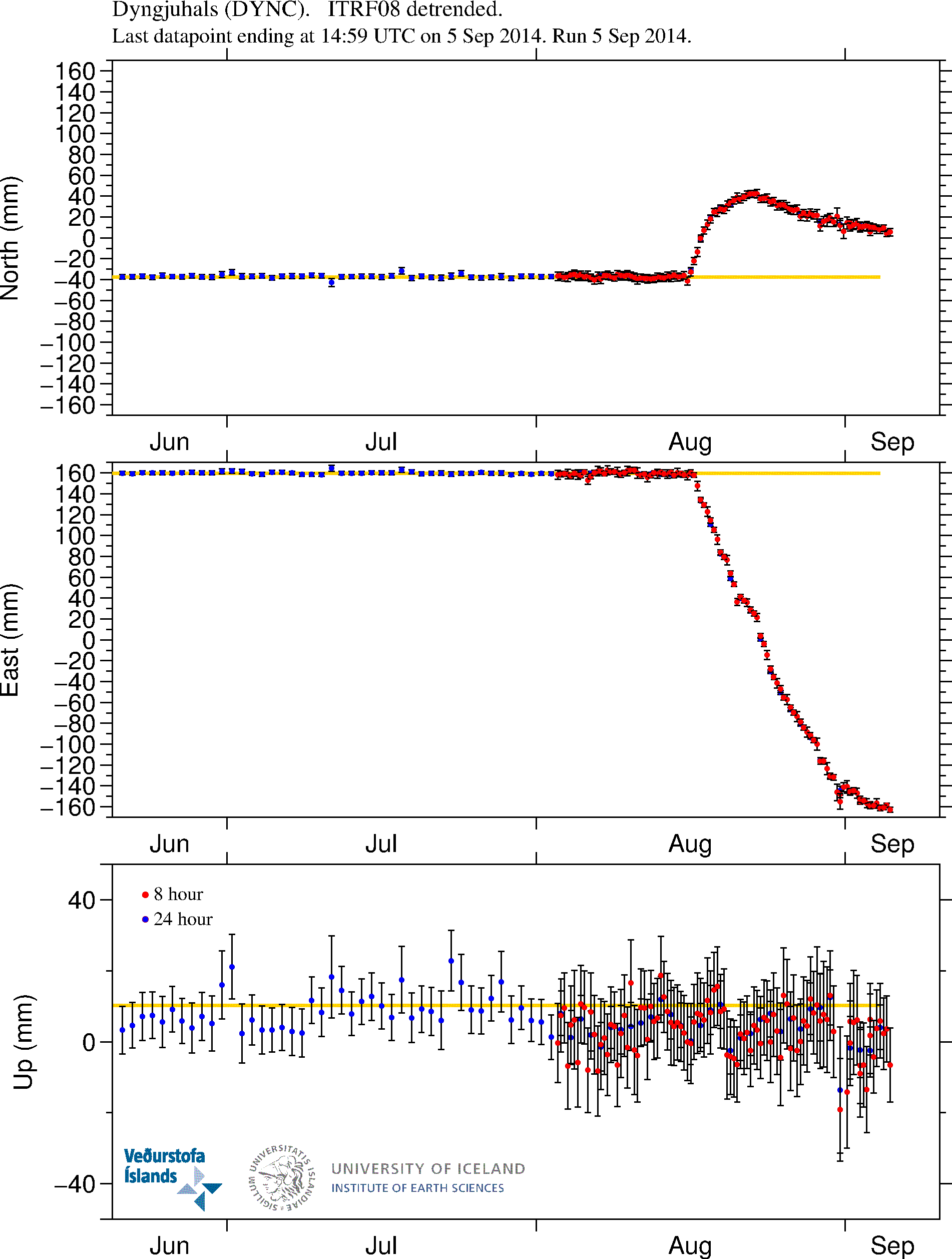
GPS measurements of the inflation that is currently taking place in the dyke. More GPS data can be found here. Copyright of this image belongs to University of Iceland.
Magma continues to flow into the dyke. It is at slower rates than before, but it still flowing into the dyke at rates that current eruption is not powerful enough to equal or drop the pressure inside the dyke. This is going to result in more eruptions as we have already started to see. When and where they are going to take place is something that is not known.
The eruption area is closed to the public
Due to risk of dangerous gases and flood the eruption area is closed to the public. Anyone that is found within the closed zone is going to get heavy fine. Going to this area is also extremely risky sine the area that is now eruption is extremely unstable with the risk of new eruption opening up without warning in the fault area and even outside it (if there is a weakness in the crust the magma is going to go that way). Police in Iceland have already spotted and fined two cars that were trying to enter the closed off area. This area of Iceland is also out in the middle of nowhere. The town is up to 10 hours away in a car (due to bad roads). Weather is also extremely unpredictable and can change without warning. So if you are thinking about going on car or foot. Don’t go!
The good news is that it is still allowed to fly over the area. So get one of those tours. I don’t know what they cost, but I know they take place if weather allows.
News bits
Arrested near the Holuhraun eruption (Rúv.is)
See the lava creeping forward at Holuhraun (Rúv.is, video)
The powers at play beneath the surface (Rúv.is, video)
More news in English can be found here (Rúv.is).
Updates for 06-September-2014
- As noted by many here there is now news report on how much Bárðarbunga volcano has lowered since 16-August-2014. Bárðarbunga volcano has lowered some 15 meters according to latest measurements. This does not reduces the risk of eruption in Bárðarbunga caldera, in fact, this might increase it by a large margin. Such large drop in a mountain has not happened in Iceland since Askja 1875 when that volcano dropped some 300 meters in one of the largest eruption in the 19th century. According to the news on Rúv the caldera crust is in fact floating the magma that is keeping it up. Part of that magma is now erupting just north of Dyngjökull glacier.
- Magnitude 5,0 earthquake took place in Bárðarbunga volcano at 05:40 UTC. It was in the NE Bárðarbunga in the caldera rim.
- The risk of large eruption in Bárðarbunga volcano has increased due the current activity and drop of the caldera (as explained above). When such eruption would take place is impossible to know at this time.
- The lava field is now just 900 meters from Jökulsá á Fjöllum glacier river. It is going to get into contact with the main stream sometimes in the next 24 hour period.
- The activity in the new eruption fissure has decreased a little over the past 24 hours. It is now only erupting in one or two craters at the moment.
- There is high risk of new fissures opening in the rift valley without warning. Both outside the glacier and below it. If an eruption takes place under the glacier there is going to be sudden glacier flood that is going to hit without warning.
- Possible minor eruption might have happened under Dyngjökull glacier in last few days. As there have been cauldron formations in it. One of the cauldron is some 6 km from the glacier edge. The deepest cauldron is 35 meter deep according to radar measurements.
- A new cauldron was also found some 10 km from the edge of Dyngjujökull glacier. This suggest that minor eruption took place there in past few days.
- Blue mist has been seen today in east Iceland. It is not clear what is happening, but there are clues that this blue mist is connected to the eruption. Sensors to measure this blue mist have been sent to east Iceland. This blue mist can also be seen on satellites that Icelandic Met Office uses for weather measurements.
News bits for 06-September-2014
Rannsaka bláa móðu á Austurlandi (Rúv.is, picture of the blue mist, Icelandic)
Eldstöðvarnar í Holuhrauni – Myndband (Rúv.is, Icelandic, video)
Updates for 07-September-2014
- Earthquake with the magnitude of 5,4 took place at 07:07 UTC. This earthquake took place in the caldera rim as other earthquakes in Bárðarbunga volcano.
- The flow of magma is currently 100 to 200 m³ every second.
- The new fissure has stopped erupting according to latest news.
- There is a high risk of new fissure opening up in the erupting area without warning.
- The lava field has reached Jökulsá á Fjöllum glacier river. This is going to increase conductivity in the river as the lava goes more into the glacier river. There is a lot of steam cloud being created following this. It is not clear when the lava field is going to dam the glacier river.
- There are now only 2 – 3 craters erupting in the main erupting fissure. The power of the eruption remains the same.
- Earthquake activity continues south of current eruption. Most of the earthquake activity now is taking place in the glacier, where minor eruptions have been taking place in past few days.
- There is no sign of this activity is about to end.
- Bárðarbunga volcano caldera continues to sink. There is a lack of earthquakes in the caldera it self. That suggest the heat below the crust is high enough to make the crust soft and that prevents earthquakes from happening. More on this tomorrow (Monday).
News bits on 07-September-2014
100 – 200 rúmmetrar úr jörðu á sekúndu (Rúv.is, video, Icelandic)
Svona hefur Bárðarbunga sigið (Rúv.is, picture of the lowering of Bárðarbunga caldera, Icelandic)
Article updated at 14:04 UTC on 06-September-2014.
Article updated at 14:11 UTC on 06-September-2014.
Article updated at 18:16 UTC on 06-September-2014.
Article updated at 18:18 UTC on 06-September-2014.
Article updated at 18:29 UTC on 06-September-2014.
Article updated at 19:43 UTC on 06-September-2014.
Article updated at 14:52 UTC on 07-September-2014.
IMO confirms a 5’7 eQ at 7:08am today at BDB caldera rim and a 5’4 last night too…many 5s in there during past days… this together with the 14m cauderon in the icecap it is significant enough that highest pressure is now happening in the BDB chamber and additionally the fault is growing in length and fountains higher every day setting new event records…enjoy the observation!!!!! Observe the happenings! Eat hamburgers!
Where did you get this info?
Links? There has only been one EQ above 5 in the past 24 hrs and that was the 5.4 this morning. And the caldera drop is recorded as 15M not 14M?
I saw that 5.7 number too somewhere but assumed it was a result of the varying estimates that were coming out before IMO verified it as 5.4. It was first published as 5.6 for instance.
Does anyone know what gas is causing the blue mist or fog seen on some of the webcams today? Benjamin Franklin, during the Laki eruption, mentioned a blue haze over Europe when he visited France. Could this be similar? Sulfur? Floride? CO2? Just plain smoke and steam? Just curious to see in the webcams..
Scientific Advisory Board of the Civil Protection, meeting 7. September
September 7, 2014 12:51 pm Bardarbunga / Holuhraun No Comments
Scientists from the Icelandic Met Office and the Institute of Earth Sciences and representatives of the Civil Protection in Iceland attend the meetings of the Scientific Advisory Board of the Icelandic Civil Protection.
Conclusions of the Scientific Advisory Board of the Icelandic Civil Protection:
The eruptive activity at Holuhraun has not decreased. Magma flow is between 100 and 200 m3/s. The lava advances by about 1 km/day and its area yesterday afternoon was around 16 km2.
o The eruption sites are the same as before. The eruptive intensity on the southern fissure that opened on Friday is much less than on the northern fissure that has been active since the beginning of the eruption.
o The lava tongue now extends 11 km to the north and has reached the western main branch of Jökulsá á Fjöllum river. However, no explosive activity due to the lava and river water interaction has been observed, but steam rises from the lava.
o A white eruption cloud rises 3 – 4 km and is directed to the north and northeast.
Seismicity in the area is similar to yesterday. Around 140 earthquakes have been recorded since midnight. At 03:30 this morning, a magnitude 4.6 earthquake occurred at the rim of the Bárðarbunga caldera. Shortly after 07:00, a magnitude 5.4 earthquake occurred on the rim, one of the largest recorded since the start of the present activity.
The amount of magma flow into the dyke seems to be similar to the magma erupting from the fissures. GPS stations outside the glacier record insignificant crustal movements.
Four scenarios are still likely:
o The migration of magma could stop, resulting in a gradual reduction in seismic activity and no further eruptions.
o The dyke could reach the Earth’s surface at different locations outside the glacier. Lava flow and/or explosive activity cannot be excluded.
o The intrusion again reaches the surface under the glacier and possibly leads to a significant eruption. This would most likely produce a flood in Jökulsá á Fjöllum and perhaps explosive, ash-producing activity.
o An eruption in Bárðarbunga. The eruption could cause an outburst flood and possibly an explosive, ash-producing activity. In the event of a subglacial eruption, it is most likely that flooding would affect Jökulsá á Fjöllum. However it is not possible to exclude the following flood paths: Skjálfandafljót, Kaldakvísl, Skaftá and Grímsvötn.
Other scenarios cannot be excluded.
From the Icelandic Met Office:
The Aviation Colour Code for Bárðarbunga remains at ‘orange’ and the code for Askja at ‘yellow’.
Please provide link to source next time.
Updated information
7th September 2014 08:00 – from geoscientist on duty
Earthquake activity continues in Bárðarbunga, in the northern part of the dike intrusion and in Herðubreiðartögl. Total of 70 earthquakes have been detected since midnight, the largest M5,7 at 07:08 in the Bárðarbunga caldera. The lava has reached Jökulsá á Fjöllum. Steaming occurs.
Please provide link to source next time around.
I can see where the confusion over the EQ size has occured. IMO report the same quake twice at 2 different intensities. The reported 5.7 is incorrect, it was verified at 5.4
Is that a new fissure opening nearer to cam 2?
no, i think that is just steam from the lava field..
This where the lava meets the river.
I think I’m seeing a line of dust-devils/tornados that initially looked like it could be a line of a new vent. But the smoke/dust looks very tightly column-like and moves!
The line is where the lava stream flows. You can only see him at night. Last night it was really bright between the lavafield.
I’ve also noticed occasional puffs of white within the lava field, back from the edge. Could those be bombs from the main eruption hitting — or what? Water vapor escaping from below?
How far does ejecta fly from this eruption I wonder?
Jon their has been no more information of the subsidence at Bardarbunga, do you know if it has stopped or has the aircraft not flown over it today.
I did not hear anything about it in the news so far.
That is generally SO2 that causes a bluish color.
BLUE
Maybe its sulphuric gas
I found this. Perhaps its helpful.
Ethiopia’s blue volcano burns deadly sulphuric gas
The volcano’s lava is the usual orange-red – the blue comes from flames produced when escaping sulphuric gases burn.
http://www.newscientist.com/article/mg22229700.100-ethiopias-blue-volcano-burns-deadly-sulphuric-gas.html#.VAxmHMJdUdU
The blue glow is actually the light from the combustion of sulfuric gases
http://news.nationalgeographic.com/news/2014/01/140130-kawah-ijen-blue-flame-volcanoes-sulfur-indonesia-pictures
I hear some weird terms nowadays. You get Sulphuric acid (H2SO4), you get Sulphur Dioxide (SO2), you do not get sulphuric ‘gas’, you can get vapour from the acid but not gas.
What happens in volcanoes is the Sulphur Dioxide mixes with the water vapour in clouds and becomes Sulphurous Acid (H2SO3), which is acid rain.
It is not stable and is regarded as an intermediate compound known to exists in a gaseous state.
I have updated the article with latest news.
Jon, it sounds like it might get very interesting in and around Bardarbunga.
It is going to get interesting first at the current eruption site. There is also risk of glacier flood from the Dyngjökull glacier at present time. Since a new eruption might just open up under it without warning.
Dust tornado just happened
http://hpics.li/42eb88e
That is a neat pic!
Reminds me of when the Spirit rover watched dust devils from a mountain top on Mars.
Cool, just saw an airplane on Mila-2.
Lava meets river:
https://twitter.com/RUVfrettir/status/508662642861703168/photo/1
Aha! Thanks, Mafl. A steamy encounter by the look of things. 🙂
Excellent picture Mafl of lava water interactions.
Timelapse from webcampictures last night (for those who missed it… 🙂 )
http://islandfankochbuch.blogspot.de/2014/09/aktuelle-situation-am-bararbunga-stand.html
Thank you. Interesting to watch – for the patience-challenged who cant stare all day long. haha
Is the second fissure site to the south still active? There is no news about it and it seems dissapeared from the webcams. Anybody knows?
No, it seems to have subsided for the moment.
i see smoke in front of the cam 1 … someone now where its coming from?
I don’t exactly know what you mean, but on cam 1 just to the right of the radar dome at the base of the dark cloud you can see very clearly how water vapour is developing, looks rather close to the camera as it is clearly visible and seems as if warm air is rising up and then condensating.
Watch Cam 1 strange cloud formations potential tornado forming ??
It certainly makes very interesting watching, Veronica. Looks like rain is sweeping through now.
looks like a lot of the pics tweeting lately are coming from this facebook page
https://www.facebook.com/earthice.UI?_fb_noscript=1
veronica, i see what you mean about the cloud formation, small grey clouds are froming just below the cloud base and rising to join the main cloud.
Perhaps it doing it because of the convective heat from the lava field! Just a guess.
It does remind me of forming tornados I’ve witnessed in Wisconsin USA.
And that even looks like a tornadic wall cloud now … but I refuse to believe it. A quick check of google didn’t get me far because I found myself too amazed by the video in this article about the kind of volcano dust devils we’ve already seen to resist coming back and posting it: http://www.slate.com/blogs/bad_astronomy/2014/02/07/volcano_twisters_ash_devils_spawned_from_sinabung.html
Very dramatic weather. Does the river boil in a large way?
there was a wallcloud an hour ago, with a thin just visable tornado, looks to me wasn’t caused by the lava stream, anyone has pics?
In the newspiece Jon added on the subsidence in the caldera it seems like they relate the 15m drop to some 2011 radar measurements. Dont they compare the current measurements with radar data obtained during their first flights 3 weeks ago when the activity started? If not, there could have been a wealth of our processes leading to a 15m drop in the last 3 years. Just two years with less precipitation and you get your 15m…
Localy in the caldera. Dont think so.
Even if its not the precip, there could have been thousand of other things leading to such a drop within 3! years. The thickness of a glacier is not fixed in time… or am I mistaking?
I think we have to trust the Icelanders.
http://www.ruv.is/files/myndir/bardarbunga_laekkukn_thversnid.jpg
Jon, will the current combination of increased water vapour and SO2 emissions have much impact on the acidity of rainfall in the local/wider area?
That is not known at the moment, but there are concerns for people health at present time.
Of course. I’m keeping your fellow countrymen and women in my thoughts, and wish them well. Those who are further afield also.
Hi. I’m student in climatology and will specialize in meteorology next year at the university of Reading in Uk, hoping to become a weather forecaster in a couple of years 😉
These cloud formations beneath the cloud’s floor are just condensation. The condensation level (that is the level where the water vapor – contained in the lowest levels of the atmosphere – is condensed in liquid water clouds) is lowering because of the high surface temperature and the high humidity in the area around the lava flow. The higer is the temperature, the more the air parcel is able to contain heavy humidity, the lower is the condensation level.
Nice answer. Thanks.
Nice one Lombeau, case closed.
(dare i say it was knida on the right track?) 🙂
Make that: dare i say i was kinda on the right track!
Double rainbow over the eruption
https://twitter.com/birtalif/status/508669817583595520/photo/1
Is it not a lot of lava flow now from the eruption???
On a lighter note, and I know this has been remarked elsewhere, I keep expecting to see C3P0 standing next to that doppler truck, watching the storm.
Ha! 🙂
Nice. As a bit of fun, why don’t we dream up a name for doppler truck?
Mine might be “Frimanaut” !!!!
……sorry that should be “Frimannaut”
To me it looks like an Anðroiþ 🙂
Thats R2D2
The eruption on camera 2 looking good tonight.
Yes. More lava and closed calderas open again i think.
Is someone maintaining the mila webcams? (They need their lenses cleaned from time to time i presume). And just a noob question: are they solar powered or battery driven? (I do’nt imagine a wall plug up there on that hill).
Steam on Bardar cam 1 just rose up & turned to (& joined) cloud… no joke!
Some commentary on the composition of the gasses from fissures
twitter @Mike Burton_volc
https://www.youtube.com/watch?v=aFVdCDUdjqw&feature=youtu.be
A Brunderbuggy even 🙂
Fab views on the webcams especially Cam2. That big fountain to the left is really throwing the lava out!
Yes … after a week or so watching i almost feel i’m camping there 😉
http://media-cache-ec0.pinimg.com/originals/64/ff/59/64ff590cfba0024a2ecfb13dd244e650.jpg
Don’t think you’ll be needing that campfire TvS, i think it’s quite warm enough there now! 🙂
Have the lava fountains changed in height does anybody know?
Hi Wurzeldave, I’ve also been following the UK Weatherworld climate & science chat forum and in today’s comments (489 and 490) there’s mention of estimates suggesting 250 m (800 ft). The source of these estimates isn’t specified, however.
http://volcanocafe.wordpress.com/2014/09/06/changes-in-bardarbunga-caldera/comment-page-7/#comment-149119
Please don’t just post links. In the future I am going to delete such comments. No questions asked.
Aha! Many thanks, Flatlander. 🙂
Has their been any information on. The cauldron near or under the glacier, has it got any bigger or deeper.
Not today. It is weekend and I don’t think any major observations are done during the weekend unless needed (they are saving money).
anyone see the dragon in mila cam one,. I have a pic of it but hey cant seem to share that,. looks great,.
Sept 7 about 5 pm edt
It’d be nice if this html image works if not – here is pic link
http://i59.tinypic.com/x5b1nn.jpg
https://fbcdn-sphotos-a-a.akamaihd.net/hphotos-ak-xaf1/v/t1.0-9/10609454_10154553372450532_5884952830490225963_n.jpg?oh=a193ff9f577b05f99e3e172c7164b5ae&oe=548A6D3E&__gda__=1418141066_09ec405114c34a619d691b1e09fbe60d
can you see the dragon in the volcano,. cool huh?
Indeed, cool but a red hot dragon sure enough! I’m scared now man!
lol , who knew right,.
Hells fury unleashed, hmmm………..
Please don’t just post links. In the future I am going to just delete those types of comments. No question asked.
sorry about that,. its just that i dont know how to share pictures on here ,.
Just post the link with some text about it. Too many pictures in the comment are going to slow down the load time for people on this website and that is not a good thing.
Same goes for youtube videos and other video based objects.
ok, thats a deal 🙂
Yes and she’s a magnificent beast, she should be called the Holuhraun Dragon spirit.
now that was actually a cool name 🙂
Here’s an article that came across twitter just now, from 1998 about past changes to the caldera. My volcanology is not adequate to interpret it (I’ve only recently first heard of the “beachballs” aka “earthquake focal mechanisms” shown in the first image) but the gist apparently is B’s caldera has had similar unrest in the fairly recent past (if not quite so severe, and uplift, not collapse) without a subsequent eruption from the caldera itself.
http://www.ldeo.columbia.edu/~ekstrom/Projects/EQS/Iceland/
I’m still trying to understand beachballs (important for really grasping what’s happening in the B caldera). This video is the most helpful for a beginner like me I’ve found so far. https://www.youtube.com/watch?v=MomVOkyDdLo
Probably way too off topic but I bet the beachball for this one was pretty entertaining to interpret, seeing as how they’re also used to differentiate between nuclear tests and earthquakes.
http://www.rawstory.com/rs/2014/09/07/meteor-strikes-near-nicaraguas-capital-leaving-39-foot-crater/
(thankfully and somewhat miraculously, no one was injured)
That recent 3.7 in the caldera is only .1k deep. There’s a lot more ice on top of it than rock. Those depth determinations must be tricky, too, with all that ice on top and the elevated caldera rim, and the actual elevation of the surface changing in real time!
3.7 at 0.1km depth…That depth would suggest an ice quake maybe?
No, it is 100 meters down in the crust. This is too big event to being an ice-quake. Normally ice-quake have just magnitude of 0,0 – 1,5 at most.
I did wonder how large ice quakes could realistically be!
Interesting development, though I can’t see any increase in tremor…Will wait and see what this means 🙂
Thank you Jon for a great website and for the clear insight and comments. Just letting you know that they are being enjoyed all the way from New Zealand. I have been enjoying the coverage since this event began and even noticed a couple of mentions of our own Taupo super volcano although we here just call it Lake Taupo which seems less threatening. Our thoughts are with those residing on Iceland and hope that this event does not lead to major disruption or loss.
umm, has the activity picked up again at Askja?
what do you think about that Jon?
http://i58.tinypic.com/33mo3gp.jpg
Any ideas on what that light is?
river backing up
Lunar reflection?